16 Nielsen & Nielsen: Nearshore sediments in non-tidal environment Fig. 1. Map showing <strong>the</strong> location <strong>of</strong> <strong>the</strong> study area in <strong>the</strong> central part <strong>of</strong> <strong>the</strong> bay Køge Bugt. <strong>the</strong> oldest one reaches a height <strong>of</strong> 1.6 m and <strong>the</strong> youngest 1.9 m. The morphological border between <strong>the</strong> marine foreland and <strong>the</strong> beach (fig. 3) shows in <strong>the</strong> permanent vegetation, here mainly Elymus arenaria, at a level <strong>of</strong> about 1.3 m DNN (Danish Ordnance Datum), corresponding to <strong>the</strong> average <strong>of</strong> <strong>the</strong> highest water-levels. Fig. 2. Cross pr<strong>of</strong>ile <strong>of</strong> Jersie Strand, Køge Bugt. The pr<strong>of</strong>ile shows <strong>the</strong> main elements <strong>of</strong> <strong>the</strong> coastal zone: <strong>the</strong> lagoon, <strong>the</strong> <strong>of</strong>fshore bar, and <strong>the</strong> nearshore terrace with <strong>the</strong> investigated section inserted. Zone 1: —5 to +130 cm DNN, width c. <strong>15</strong> m, gradient: 5°. Zone 2: —<strong>15</strong> to —5 cm DNN, width c. 50 m, gradient: 1°. Zone 3: -80 to -<strong>15</strong> cm DNN, width c. 25 m, gradient: 2°. JERSIE STRAND. KØGE BUGT The dynamics and <strong>the</strong> morphology <strong>of</strong> <strong>the</strong> inshore zone have been investigated among o<strong>the</strong>rs by Schou (19<strong>45</strong>), King & Williams (1949), King (1959, 1972), Hayes & Broothroyd (1969), Hayes (1972), and Davis & Fox (1972). In <strong>the</strong>se papers <strong>the</strong>re seems to be some uncertainty as to terminology for <strong>the</strong> easily moved bar type on <strong>the</strong> nearshore — called <strong>the</strong> (migrating) nearshore bar by <strong>the</strong> present authors. The terms ridges and runnels are used by Davis & Fox (1972) for a tideless environment (Lake Michigan); to some degree, <strong>the</strong>y are thus departing from earlier authors' use <strong>of</strong> this term, such as King & Williams (1949) who define ridges and runnels as bar systems on very broad foreshores in typical tidal environments. Unfortunately, King & Williams, on <strong>the</strong> o<strong>the</strong>r hand, a<strong>pp</strong>ly <strong>the</strong> term swash bars for <strong>the</strong> migrating bars produced in a model basin and which correspond in shape to Davis & Fox's ridges and runnels; however, <strong>the</strong>se artificial bars differ essentially from <strong>the</strong> accumulation <strong>of</strong> sediments occurring on <strong>the</strong> foreshore in consequence <strong>of</strong> <strong>the</strong> swash/backwash dynamics during swells. The names <strong>of</strong> <strong>the</strong> different coastal zones treated in this work and <strong>the</strong>ir location on <strong>the</strong> coastal pr<strong>of</strong>ile a<strong>pp</strong>ear from <strong>the</strong> term diagram below (fig. 4). It might be reasonable, however, first to comment on <strong>the</strong> diagram terms as to <strong>the</strong> subdivisions <strong>of</strong> <strong>the</strong> inshore zone, namely breaker zone, shoreface, and nearshore terrace, each covering a specific relief <strong>of</strong> <strong>the</strong> sea bottom where different form elements are produced at rising and falling water-levels. If, for example, we imagine <strong>the</strong> water-level drops considerably in <strong>the</strong> investigated area because <strong>of</strong> a temporary wind set-up in <strong>the</strong> Baltic, <strong>the</strong> water surface might cut <strong>the</strong> nearshore zone at <strong>the</strong> outer nearshore bar shown on <strong>the</strong> diagram. The foreshore dynamic would move seaward with a subsequent building up <strong>of</strong> one or more swash bars on <strong>the</strong> stoss side <strong>of</strong> <strong>the</strong> outer nearshore bar. As <strong>the</strong> swash zone on tideless coasts is identical with <strong>the</strong> foreshore, <strong>the</strong> total CROSS SECTION OF THE BARRIER SEPT. 14th. 1971 2 1 DNN -1 -2 -LAGOON »J« •BARRIER- metre 50 -1 1 100 -»!« INSHORE : RESEARCH SECTION -ZONE 2- Z0NE1 -1 1 1 1 1 1— —i v 200 — i — i — i — i — i — i — 300 metres JN/NN
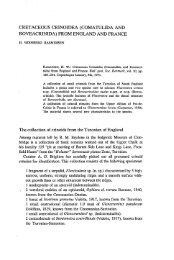
<strong>Bulletin</strong> <strong>of</strong> <strong>the</strong> <strong>Geological</strong> <strong>Society</strong> <strong>of</strong> <strong>Denmark</strong>, vol. <strong>27</strong> 1978 17 •Hi i » V! V HP : -%_ .* fc WM F/g. 3. Part <strong>of</strong> aerial photograph <strong>of</strong> Jersie Strand from 21/4 1971. The pr<strong>of</strong>ile line from fig. 2 is inserted and shows <strong>the</strong> nor<strong>the</strong>rn border <strong>of</strong> <strong>the</strong> study area. 1. breakpoint bar; 2. nearshore bar; 3. beach and 4. swells. (Air photo: LLO). 2 D.g.F. <strong>27</strong>