Lower Baraboo River - Wisconsin Department of Natural Resources
Lower Baraboo River - Wisconsin Department of Natural Resources
Lower Baraboo River - Wisconsin Department of Natural Resources

Create successful ePaper yourself
Turn your PDF publications into a flip-book with our unique Google optimized e-Paper software.
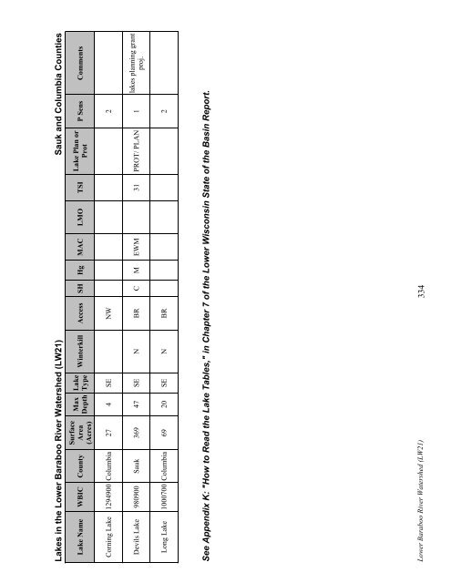
Lakes in the <strong>Lower</strong> <strong>Baraboo</strong> <strong>River</strong> Watershed (LW21) Sauk and Columbia Counties<br />
Lake Name WBIC County<br />
Surface<br />
Area<br />
(Acres)<br />
Max<br />
Depth<br />
Lake<br />
Type<br />
Winterkill Access SH Hg MAC LMO TSI<br />
Lake Plan or<br />
Prot<br />
P Sens Comments<br />
Corning Lake 1294900 Columbia 27 4 SE NW 2<br />
Devils Lake 980900 Sauk 369 47 SE N BR C M EWM 31 PROT/ PLAN 1<br />
lakes planning grant<br />
proj.<br />
Long Lake 1000700 Columbia 69 20 SE N BR 2<br />
See Appendix K: "How to Read the Lake Tables," in Chapter 7 <strong>of</strong> the <strong>Lower</strong> <strong>Wisconsin</strong> State <strong>of</strong> the Basin Report.<br />
<strong>Lower</strong> <strong>Baraboo</strong> <strong>River</strong> Watershed (LW21) 334
![Nature program winter schedule [PDF] - Wisconsin DNR](https://img.yumpu.com/22471254/1/190x245/nature-program-winter-schedule-pdf-wisconsin-dnr.jpg?quality=85)
![City of Middleton [PDF] - Wisconsin Department of Natural Resources](https://img.yumpu.com/22300392/1/190x245/city-of-middleton-pdf-wisconsin-department-of-natural-resources.jpg?quality=85)
![Wetland Conservation Activities [PDF] - Wisconsin Department of ...](https://img.yumpu.com/21975633/1/190x245/wetland-conservation-activities-pdf-wisconsin-department-of-.jpg?quality=85)
![Baraboo River Region[PDF] - Wisconsin Department of Natural ...](https://img.yumpu.com/21975619/1/190x245/baraboo-river-regionpdf-wisconsin-department-of-natural-.jpg?quality=85)