Handbook of Surveillance Technologies (3rd Ed) - The Real Faces of ...
Handbook of Surveillance Technologies (3rd Ed) - The Real Faces of ...
Handbook of Surveillance Technologies (3rd Ed) - The Real Faces of ...

Create successful ePaper yourself
Turn your PDF publications into a flip-book with our unique Google optimized e-Paper software.
Chapter 1 - Introduction & Overview<br />
Governments are Making Greater Use <strong>of</strong> Commercial Images, in addition to government<br />
sources, to monitor other nations. Left: Satellite images <strong>of</strong> the islands <strong>of</strong> Japan, 9<br />
May 1998. Right: Egypt, Saudi Arabia, and the Middle East, 3 April 1998. [News photos<br />
©1998 OrbImage, now GeoEye as per licensing instructions.]<br />
3.c. Commercial, Agricultural, and Government Applications<br />
<strong>The</strong>re are tens <strong>of</strong> thousands <strong>of</strong> legal surveillance applications. Examples include ATM<br />
security, public safety monitoring in tunnels and transportation systems, and environmental<br />
monitoring to preserve artifacts and artworks in museums and educational institutions.<br />
Insurance adjustors, property value and damage assessors, marketing and promotional pr<strong>of</strong>essionals,<br />
contractors, city planners, investigative journalists, weather forecasters, architectural<br />
planners, livestock and food inspectors, surveyors, fishers, crop yield assessors, forestry and<br />
fire-fighting personnel all use various forms <strong>of</strong> surveillance in their work.<br />
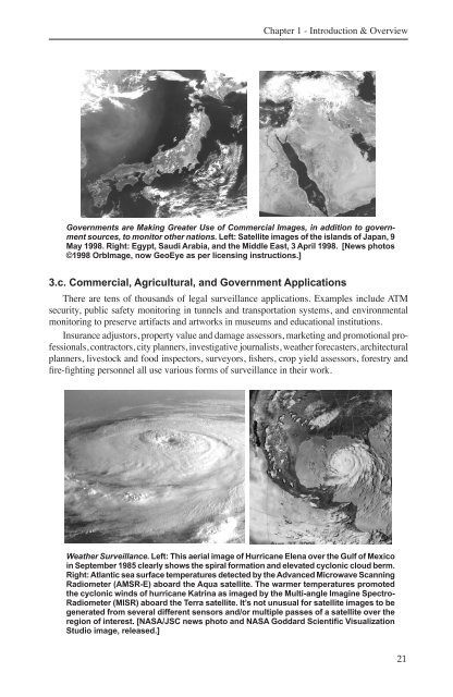
Weather <strong>Surveillance</strong>. Left: This aerial image <strong>of</strong> Hurricane Elena over the Gulf <strong>of</strong> Mexico<br />
in September 1985 clearly shows the spiral formation and elevated cyclonic cloud berm.<br />
Right: Atlantic sea surface temperatures detected by the Advanced Microwave Scanning<br />
Radiometer (AMSR-E) aboard the Aqua satellite. <strong>The</strong> warmer temperatures promoted<br />
the cyclonic winds <strong>of</strong> hurricane Katrina as imaged by the Multi-angle Imagine Spectro-<br />
Radiometer (MISR) aboard the Terra satellite. It’s not unusual for satellite images to be<br />
generated from several different sensors and/or multiple passes <strong>of</strong> a satellite over the<br />
region <strong>of</strong> interest. [NASA/JSC news photo and NASA Goddard Scientific Visualization<br />
Studio image, released.]<br />
21