Slope stability along active and passive continental margins ... - E-LIB
Slope stability along active and passive continental margins ... - E-LIB
Slope stability along active and passive continental margins ... - E-LIB

Create successful ePaper yourself
Turn your PDF publications into a flip-book with our unique Google optimized e-Paper software.
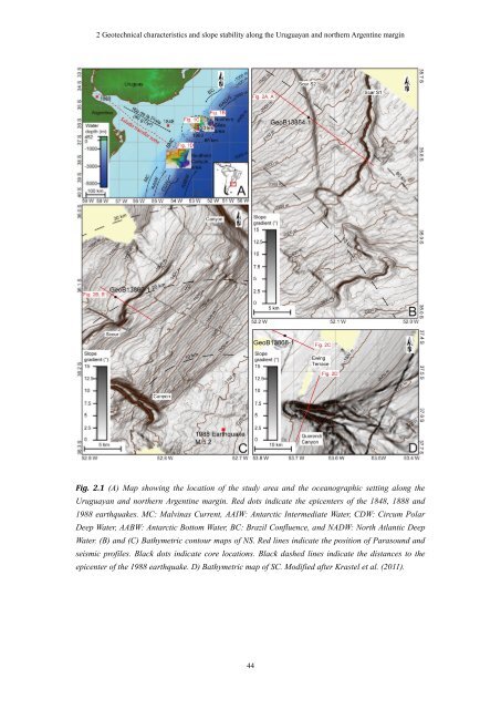
2 Geotechnical characteristics <strong>and</strong> slope <strong>stability</strong> <strong>along</strong> the Uruguayan <strong>and</strong> northern Argentine margin<br />
Fig. 2.1 (A) Map showing the location of the study area <strong>and</strong> the oceanographic setting <strong>along</strong> the<br />
Uruguayan <strong>and</strong> northern Argentine margin. Red dots indicate the epicenters of the 1848, 1888 <strong>and</strong><br />
1988 earthquakes. MC: Malvinas Current, AAIW: Antarctic Intermediate Water, CDW: Circum Polar<br />
Deep Water, AABW: Antarctic Bottom Water, BC: Brazil Confluence, <strong>and</strong> NADW: North Atlantic Deep<br />
Water. (B) <strong>and</strong> (C) Bathymetric contour maps of NS. Red lines indicate the position of Parasound <strong>and</strong><br />
seismic profiles. Black dots indicate core locations. Black dashed lines indicate the distances to the<br />
epicenter of the 1988 earthquake. D) Bathymetric map of SC. Modified after Krastel et al. (2011).<br />
44