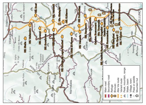
Rif. Biella Rif. Vallandro Rif. Lorenzi Rif. Bosi Rif. Soraforca Rif. Dibona Rif. Vandelli Rif. Croda da Lago-Palmieri Biv. Slataper Rif. S.Marco Rif. Città di Fiume Rif. Venezia Rif. Dolomites Rif. Remauro Biv. Cas. Campestrin Main road Secondary road Refuge Bivouac Alta Via route Variant route Peak, mountain, range Water, basin Village, town Pass or saddle Mountain hut Casèra Bosconero Biv. Tovanella Rif. Casèra Sora el Sass-Angelini Casèra Busnìch Rif. Sommariva Rif. Bianchet Biv. Sperti Rif. 7°Alpini Rif. Pian de Fontana e Biv. Dal Mas Biv. Màrmol-Bocco
which runs almost always through the wood near the right bank of the torrent. Beautiful view over the Croda Marcòra. After a comfortable, rewarding walk of about 5km, you reach the Ponte Geralba, 997m, near San Floreano. Go up the opposite side and after another 2km, you come to San Vito di Cadore, 1011m, where Day Three ends. 7 hours from the Rifugio Vandelli. Particular view of the Antelao from the Cristallo area The Rifugio Tondi, privately owned, offers basic hotel services with typical local cooking. 8 beds, mains electricity, hot water and shower. Tel: 0436 5775 From the Rifugio Tondi, continue west until you come to a fork in a hollow near the top of a ski lift. Here you take to the left (south-west) path 214, which, with a wide curve, takes you right back to the southeast into the Val Orita. When you reach the valley, go down towards the bottom until you are just under a narrow where the path turns decisively right (west) and leads you over a steep and very panoramic mountainside on the mountains of the Val Bòite (Antelao, Pelmo, Croda da Lago, Tofàne). You now enter the wood and descend until you meet a little road which leads to Zuèl, c.1170m, a ward of Cortina d’Ampezzo, where you can get the bus to San Vito di Cadore. From Zuèl, if you decide to continue on foot, you should head fro the ward of Socòl along the road of the Olympic ski-jump, then down to the Bòite torrent, beyond which you go onto the road marked n.426 San Vito di Cadore is an important summer and winter holiday resort, in a superb position, with wonderful views. Close to Cortina d’Ampezzo, and an excellent base for walks and hikes to the Pelmo, Antelao, Sorapìss and Marmaròle. Lovely alpine lake nestling in the greenery. Worth a visit are: the Chiesa Parrocchiale (Parish Church), dating from 1764, Chiesetta (little church) della Madonna della Difesa (1512 – 1516) and the Museo delle Tradizioni Populari (Folk Traditions Museum). Tennis, mountain bike, skating. Bank ; chemist; all types of shops; one to four-star hotels; guesthouses. For accommodation in private houses, contact the Tourist Office in Via Nazionale, 9. Tel: 0436 9119. Variant 3 From the Rifugio Vandelli to San Vito di Cadore along the Percorso alpinistico attrezzato (Equipped mountaineering route) “Francesco Berti”. This is a mountaineering itinerary with stretches which are very exposed and partially equipped; it is therefore suitable only for expert hikers with appropriate equipment. It is a little shorter than the original day’s route, but considerably harder. The first part of the descent down the erosion channel is particularly tricky. From the Rifugio Vandelli, go round the shores of the lake, following path n.215 south-west and then go up towards the Tonde de Sorapìss. About 300 metres before the impassable Forcella (or Valico) sóra la Cengia del Banco, which lies between the Punta Negra and the Fopa di Matìa, the path, now marked n.242, goes left and enters into a rocky erosion channel which leads onto the Cengia del Banco itself. This ledge, always very exposed and with the risk of falling 30 HIGH MOUNTAIN PATHS FROM VILLABASSA-NIEDERDORF TO LONGARONE THE DOLOMITES “ALTA VIA” N.3 OR “DEI CAMOSCI” 31