FG lecture 1.pdf - University of Sulaimani
FG lecture 1.pdf - University of Sulaimani
FG lecture 1.pdf - University of Sulaimani

You also want an ePaper? Increase the reach of your titles
YUMPU automatically turns print PDFs into web optimized ePapers that Google loves.
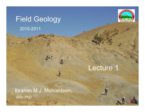
Field Geology<br />
2010-2011<br />
Lecture 1<br />
Ibrahim M.J. Mohialdeen,<br />
MSc,PhD
* Subject: Introduction and Instruments<br />
* <strong>lecture</strong>r’s name: Ibrahim M.J. Mohialdeen<br />
* Contacts: Tel: 0770 142 6262, Email: ibrahim.jaza@univsul.net<br />
* Subject objective:<br />
This <strong>lecture</strong> is an introduction to the course <strong>of</strong> Field Geology. The main<br />
safety processes will be discussed. The main instruments including<br />
compasses are discussed. The last part will be focused on the GPS and<br />
how to be used by geologists in the field.<br />
* Scientific content <strong>of</strong> the subject:<br />
Introduction<br />
Safety<br />
Compasses<br />
Equipment and Instruments<br />
GPS<br />
* Subject references:<br />
<br />
- Compton, R.R., 1962, Manual <strong>of</strong> Filed Geology, John Wiley and Sons, New York, 378p.<br />
- Lahee, F.H., 1961, Field Geology,6 th ed., McGraw-Hill Book Company, New York, 926p.<br />
Field Geology 2010-2011
UNIVERSITY OF SULAIMANI<br />
COLLEGE OF SCIENCE<br />
DEPT. OF GEOLOGY<br />
2010-2011<br />
Field Geology<br />
3 rd Year Geology<br />
( One semester )<br />
Ibrahim M.J.Mohialdeen, M Sc, Ph D<br />
E-mail: ibrahim.jaza@univsul.net<br />
Hall No. : 10 Date: Monday Time: 8:30-10:30<br />
Field Geology 2010-2011
Two hours/week<br />
An outline <strong>of</strong> the course (Theory):<br />
• Introduction<br />
Outline and approach, Safety in the field, Filed maps, Field notebooks, Field clothing<br />
• Instruments and equipment<br />
Hammers and chisels, Compasses and clinometers, Handlenses, Tapes, Map cases,<br />
Protractors, Pencils and erasers, Acid bottles<br />
• Geological maps and base maps<br />
Types <strong>of</strong> geological map, Topographic base maps, Geographic coordinates and<br />
metric grids, Position finding on maps, Global positioning systems (GPS)<br />
• Methods <strong>of</strong> geological mapping<br />
Traversing, Following contacts, Mapping in poorly exposed regions, Drilling,<br />
Geophysical aids to mapping, Photogeology<br />
• Field measurements and techniques<br />
Measuring strike and dip, Plotting strike and dip, Recording strike and dip,<br />
Measuring linear features, Specimen collecting, Field photography, Map symbols<br />
• Rocks, fossils and ores<br />
Field work with sedimentary rocks, Field work with igneous rocks,<br />
Field work with metamorphic rocks, Fossils, Economic geology<br />
• Cross-sections and three-dimensional illustration<br />
Cross-sections, Columnar sections, Three-dimensional illustration<br />
• Geological reports<br />
Preparation, Layout, Introduction, Main body <strong>of</strong> the report, Conclusions, References<br />
Field Geology 2010-2011
An outline <strong>of</strong> the course (Practice):<br />
For detailed <strong>of</strong> the practical work see the website: shadan.hamakhan@univsul.net<br />
3hours/week<br />
• 1- Field instruments; compass, clinometers, hand level, GPS<br />
• 2-Base maps; topographic map, scales, geographic<br />
coordinates, position finding on maps<br />
• 3-Traversing; close traverse, road traverse, stream traverse,<br />
following contacts<br />
• 4-Field measurements; measuring, plotting and recording<br />
strike and dip, measuring linear features<br />
• 5-Sample collecting; rocks, fossils and ores<br />
• 6-Drawing sections; cross-sections, columnar sections,<br />
models<br />
• 7-Writing geological reports and presentation<br />
• Note: The course contains many field trips for applying<br />
all <strong>lecture</strong>s.
Marks<br />
Theory :<br />
Quizzes<br />
Written Exams<br />
5marks<br />
5marks<br />
Practice:<br />
Reports:<br />
Final Exams:<br />
Final Exam:<br />
5marks<br />
10marks<br />
25marks<br />
Field Geology 2010-2011
Welcome to the Field work..
Lecture 1:<br />
Introduction<br />
• Outline and approach<br />
This course is arranged in order to give you the necessary<br />
information about going to the field and how to do mapping. It<br />
describes the instruments and equipment he/she will need in<br />
the field. Methods <strong>of</strong> finding himself on his maps are also<br />
described. Measurement methods, drawing cross-sections and<br />
the preparation <strong>of</strong> other diagrams for geological features are<br />
explained. Sample collecting and description <strong>of</strong> rocks will be<br />
discussed in detail. The last chapter will discuss on the writing<br />
the report and how to do presentation <strong>of</strong> data and results.<br />
The approach throughout is practical. The main object is to tell<br />
the student what to do in the field to collect the evidence from<br />
which to draw his conclusions. The detailed program <strong>of</strong> the<br />
course is given in the attached sheet.<br />
Field Geology 2010-2011
Safety in the field:<br />
• -Geological fieldwork is not without hazards. A brief list <strong>of</strong> do's<br />
and don't s for the field is given:<br />
1-Do not run down the hills.<br />
2-Do not climb rock faces unless it is essential to do so.<br />
3-Do not enter old mine workings or cave systems except by<br />
arrangement, and always in company.<br />
4- Always work in pairs or in close association in rugged<br />
mountains. Wear easily seen clothing.<br />
5-Never use one hammer as a chisel and hit it with another.<br />
6- Do not hammer close to other people.<br />
• -All geologists should take a course in first aid and keep a first<br />
aid kit and manual in camp with<br />
them.<br />
• -Distress signals<br />
• -Exposure<br />
• -Lightening<br />
• -Students in the field.
• Filed maps and Field notebooks:<br />
• Field maps and notebooks are valuable documents<br />
which constitute part <strong>of</strong> the record <strong>of</strong> the field<br />
evidence on which the interpretation <strong>of</strong> geology<br />
depends. Keeping both <strong>of</strong> them clean and clear is<br />
important and necessary.<br />
• Field clothing:<br />
(Temperate/cold climates)<br />
Anorak or cagoule, waterpro<strong>of</strong> jacket, sweaters,<br />
socks, boots, woolly hat, gloves shirts, trousers<br />
(Warm climates)<br />
Long-sleeved shirts, short-sleeved shirts, loose<br />
'jeans', jungle hat, sunglasses<br />
Field Geology 2010-2011
Instruments and equipment<br />
• Hammers and chisels:<br />
• Any geologist going into the field needs at<br />
least one hammer with which to break<br />
rock. Sometimes a cold chisel is needed to<br />
break out a specific piece <strong>of</strong> rock or fossil.<br />
Some geologists carry their hammers in a<br />
"frog" or hammer holster, as this leaves<br />
their hands free for climbing, writing and<br />
plotting.<br />
Field Geology 2010-2011
Hammers and chisels<br />
Field Geology 2010-2011
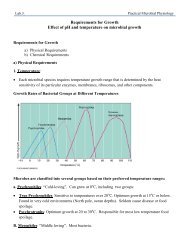
Compasses and clinometers:<br />
• The ideal compass should be designed.<br />
• Brunton type: it is American type (Fig.1)<br />
• Silva: Swedish compass.<br />
• Both types are reasonably priced, welldamped<br />
needle compasses.<br />
• Compass description:<br />
• All parts <strong>of</strong> the Brunton compass are<br />
explained on the figure.<br />
Field Geology 2010-2011
Brunton Compass<br />
Field Geology 2010-2011
Types <strong>of</strong> Compasses<br />
Field Geology 2010-2011
Types <strong>of</strong> Compasses<br />
Field Geology 2010-2011
Silva Compass<br />
Field Geology 2010-2011
• Handlenses: A magnification <strong>of</strong> from 7 to 10 times is probably the<br />
most useful.<br />
• Tapes: You can use a 3m tape to measure everything from grain<br />
size, to bed thickness, and even as scale for close-up photographs<br />
<strong>of</strong> rock surfaces and fossils in place. A geologist also occasionally<br />
needs a 10m or 30m "linen" tape for small surveys.<br />
• Map cases: a map case is obviously essential where work may<br />
have to be done in rain or in mist; but even in warmer climes,<br />
protection from both the sun and sweaty hands is still needed. The<br />
best are probably home made ( Fig. 2 )<br />
• Protractors: Carry at least one small protractor (10 cm diameter)<br />
and one <strong>of</strong> 15-20cm .<br />
• Pencils and erasers: At least three lead pencils are needed in the<br />
normal course <strong>of</strong> mapping; a hard pencil (4H or 6H) for plotting<br />
bearings; a s<strong>of</strong>ter pencil (2H or 4H) for plotting strikes and writing<br />
notes on the map; and a further pencil (2H) for writing in your<br />
notebook.<br />
Field Geology 2010-2011
Field Geology 2010-2011
• Acid bottles: Always carry an acid bottle in your<br />
rucksack. It should contain a small quantity (5ml) <strong>of</strong>10%<br />
hydrochloric acid.<br />
• Global positioning system (GPS):<br />
• Students should at least know what GPS ( Fig.3). GPS<br />
uses compact hand-held instruments which lock on to<br />
US satellites to locate you on the ground to within 10m.<br />
Functions vary between makes: some give latitude and<br />
longitude, others grid references, some both. Most show<br />
your route, speed and bearing, and bleep when you<br />
reach designated "way points". Altitude is also given. As<br />
GPS needs line-<strong>of</strong>- sight to satellites, it does not work in<br />
forests or steep valleys, and it performs poorly in cold<br />
weather.<br />
Field Geology 2010-2011
Global positioning system<br />
Field Geology 2010-2011
Pressure altimeter<br />
• Digital barometric pressure sensor for altitude measurement in consumer electronic applications<br />
• A pressure altimeter (also called barometric altimeter) is the altimeter found in mostaircraftIn it, ananeroid<br />
barometermeasures theatmospheric pressurefrom astatic portoutside the aircraft. Air pressure decreases with<br />
an increase <strong>of</strong> altitude—approximately 100millibarsper 800metersor oneinch <strong>of</strong> mercuryper 1000feetnearsea<br />
level<br />
• The altimeter is calibrated to show the pressure directly as an altitude abovemean sea levelin accordance with a<br />
mathematical model defined by theInternational Standard AtmosphereISA). Older aircraft used a simpleaneroid<br />
barometerwhere the needle made less than one revolution around the face from zero to full scale. Modern aircraft<br />
use a "sensitive altimeter" which has a primary needle that makes multiple revolutions, and one or more secondary<br />
needles that show the number <strong>of</strong> revolutions, similar to aclock faceIn other words, each needle points to a<br />
different digit <strong>of</strong> the current altitude measurement<br />
• Diagram showing the internal components <strong>of</strong> the sensitive aircraft altimeter<br />
• On a sensitive altimeter, the sea level reference pressure can be adjusted by a setting knob. The reference<br />
pressure, in inches <strong>of</strong> mercury inCanadaand theUSand millibars (orhectopascalselsewhere, is displayed in the<br />
KollsmanWindowvisible at the right side <strong>of</strong> the aircraft altimeter shown here. This is necessary, since sea level<br />
reference atmospheric pressure varies with temperature and the movement <strong>of</strong>pressure systemsin the<br />
atmosphere<br />
• Inaviationterminology, the regional or local air pressure at mean sea level (MSL) is called theQNHor "altimeter<br />
setting", and the pressure which will calibrate the altimeter to show the height above ground at a givenairfieldis<br />
called theQFE<strong>of</strong> the field. An altimeter cannot, however, be adjusted for variations in air temperature. Differences<br />
in temperature from the ISA model will, therefore, cause errors in indicated altitude<br />
• Kollsman-type barometric aircraft altimeter as used in North America displaying analtitude<strong>of</strong> 80 feet<br />
• The calibration formula for an altimeter, up to 36,090 feet (11,000 m), can be written as<br />
• wherehis the indicated altitude in feetPis the static pressure andPrefis the reference pressure (use same units<br />
• for both). This is derived from thebarometric formulausing the scale height for thetroposphere<br />
Field Geology 2010-2011
The most kissed girl in the world<br />
“Ganseliesel”