Seismoacoustic Study of the Shallow Gas Transport and ... - E-LIB
Seismoacoustic Study of the Shallow Gas Transport and ... - E-LIB
Seismoacoustic Study of the Shallow Gas Transport and ... - E-LIB

You also want an ePaper? Increase the reach of your titles
YUMPU automatically turns print PDFs into web optimized ePapers that Google loves.
Chapter 3<br />
3.5. Interpretation <strong>and</strong> Discussion<br />
3.5.1. Chronostratigraphy<br />
Although for our study area published information on deep penetration drill sites is<br />
rare, age estimates for seismic units can be derived from some published seismic studies<br />
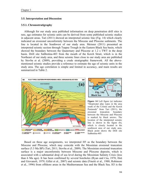
in adjacent areas. Tari (2011) showed an interpreted seismic line (Fig. 14) which clearly<br />
indicated an erosional unconformity between <strong>the</strong> Miocene <strong>and</strong> Pliocene sediments. The<br />
line is located in <strong>the</strong> Southwest <strong>of</strong> our study area. Meisner (2011) presented an<br />
interpreted seismic section through Tuapse Trough in <strong>the</strong> Eastern Black Sea basin, which<br />
showed <strong>the</strong> boundary between <strong>the</strong> Quaternary <strong>and</strong> Pliocene at 1.2 s TWT in <strong>the</strong> deep<br />
basin. Drill site Subbotina-403 from <strong>the</strong> mouth <strong>of</strong> <strong>the</strong> Kerch Strait, which is in <strong>the</strong><br />
Nor<strong>the</strong>ast <strong>of</strong> our study area, <strong>and</strong> three seismic lines close to our study area are published<br />
by Stovba et al. (2009), providing a crude stratigraphic framework. All <strong>the</strong> abovementioned<br />
seismic studies provide a reference to estimate <strong>the</strong> age <strong>of</strong> seismic units in <strong>the</strong><br />
study area. The age correlation is simple <strong>and</strong> limited in accuracy, <strong>and</strong> main results are<br />
summarized in Table 2.<br />
Figure 14 Left figure (a) indicates<br />
“Deepwater play types in <strong>the</strong> area<br />
south <strong>of</strong> <strong>the</strong> Crimea <strong>and</strong> <strong>the</strong> Kerch<br />
Peninsula” from Tari (2011), <strong>the</strong><br />
erosional truncation boundary<br />
between <strong>the</strong> Miocene <strong>and</strong> Pliocene<br />
is marked by black arrows. The<br />
location <strong>of</strong> <strong>the</strong> interpreted seismic<br />
line is shown in <strong>the</strong> figure (b),<br />
which is closely located in <strong>the</strong><br />
southwest area <strong>of</strong> our study area.<br />
Black point shows <strong>the</strong> Drill site<br />
Subbotina-403<br />
Based on <strong>the</strong>se age assignments, we interpreted H5 as <strong>the</strong> boundary between <strong>the</strong><br />
Miocene <strong>and</strong> Pliocene, which may coincide with <strong>the</strong> Messinian erosional truncation<br />
surface (5.3 Ma BP) (Tari, 2011; Stovba et al., 2009). The Messinian erosional truncation<br />
surface is a major unconformity between Miocene <strong>and</strong> Pliocene deposits, which is<br />
associated with a substantial drop <strong>of</strong> sea level during <strong>the</strong> Messinian Salinity Crisis (less<br />
than 6 Ma ago). It has been confirmed by several boreholes (Ryan <strong>and</strong> Cita, 1978; Hsü<br />
<strong>and</strong> Giovanoli, 1979; Gillet et al., 2007) <strong>and</strong> seismic data (Finetti et al., 1988; Robinson<br />
et al., 1996) from <strong>of</strong>fshore areas in <strong>the</strong> Mediterranean Sea <strong>and</strong> <strong>the</strong> Black Sea. H3 is <strong>the</strong><br />
84