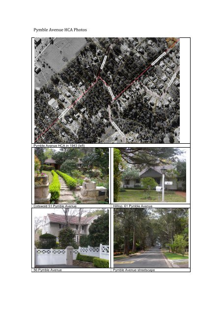
Pymble Avenue HCA Photos Pymble Avenue HCA in 1943 (left) Cotswold 51 Pymble Avenue Hilltop, 61 Pymble Avenue 56 Pymble Avenue Pymble Avenue streetscape
<strong>Ku</strong>-<strong>ring</strong>-<strong>gai</strong> <strong>Heritage</strong> <strong>Conservation</strong> <strong>Areas</strong> <strong>North</strong> <strong>Inventory</strong> <strong>Sheet</strong> Item No Item Name Item Type Group Collection Category Key Historical Periods Primary Address Local Govt. area HCA 23 WARRAWEE HERITAGE CONSERVATIONA AREA <strong>Heritage</strong> <strong>Conservation</strong> Area Urban Area Townscape 1890-1910s; Inter-war 1920s-1930s; 1940s-1960s Refer to map <strong>Ku</strong>-<strong>ring</strong>-<strong>gai</strong> Boundaries <strong>North</strong>: Across Warrawee Avenue along the northern boundary of properties at Nos 16 and 19 Warrawee Avenue and 33A Bangalla Street, along the north boundary of Gillespie Field, and across Young Street along the north boundary of 11 Young Street; East: following the eastern boundaries of properties at 1A-11 Young Street, encompassing propeties at 19 and 17 Bangalla Street, and then following Cherry Street down to No. 23-25 Cherry St; South: the south boundaries of properties at 23 -25 Cherry Street, 36-42A Hastings Road, encompassing properties at 65 and 67 Brentwood Avenue, and then following the northern side of the railway line; west: encompassing 44 & 37A Bangalla St, then following western boundaries of properties at Nos. 12-16 Warrawee Avenue National Historic Themes State Historic Theme 1 State Historic Theme 2 State Historic Theme 3 State Historic Theme 4 Building settlements towns and cities Towns, suburbs and villages Persons Domestic Life Summary Statement of Significance Warrawee <strong>Heritage</strong> <strong>Conservation</strong> Area is of aesthetic significance for its remarkable concentration of architecturally distinguished houses set within fine landscaped garden settings on large sites, many of the houses designed by notable architects including Eleanor Cullis-Hill, John Horbury Hunt, H. Joseland, Joseland & Gillings, Maurice B. Halligan, John Sulman, Hugh Venables Vernon, Waterhouse & Lake, and Wilson, Neave & Berry. Fine gardens blend with regenerated native trees and the undulating topography to create an aesthetically fine residential landscape. Warrawee <strong>Heritage</strong> <strong>Conservation</strong> Area is of historical significance as an exclusively residential area, which retains evidence of its early settlement, subdivision and continuing development, in its main road pattern created in the 1890s, and evidence of later subdivision of earlier estates such as the Pibrac Estate subdivision of 1920, which created Pibrac Avenue. A notable feature of the area’s layout, which is of historical significance, is the early creation of battleaxe allotments from the 1917 subdivision of the Warrawee Garden Estate. The area is also of historical significance for its collection of early houses associated with prominent historical figures including Pibrac, the home of Frederick Eccleston Du Faur (1832 -1915); Roseburn and Kooyong designed for two of the Gillespie brothers, proprietors of Anchor Flour Mills and prominent benefactors of Knox Grammar School, and Audley, designed for Preston L. Gowing of Gowings department stores. Warrawee was a prime timber-getting location from circa 1815, dominated by the holdings of timber contractor Thomas Hyndes to the east and west of Lane Cove Road (now the Pacific Highway). Hyndes’ land included vast stands of cedar, mahogany, turpentine, ironbark and blue gum. Hyndes had formally leased the 2000 acres (809ha) to the east of Lane Cove Road by 1822 and in 1840 the land was re-leased to John Terry Hughes, a prominent merchant and brewer, to whom a deed of KU-RING-GAI HERITAGE CONSERVATION AREAS NORTH INVENTORY