Recalculating RTK Tides.fm - Hypack
Recalculating RTK Tides.fm - Hypack
Recalculating RTK Tides.fm - Hypack

Create successful ePaper yourself
Turn your PDF publications into a flip-book with our unique Google optimized e-Paper software.
<strong>Recalculating</strong> <strong>RTK</strong> <strong>Tides</strong><br />
By Mike Kalmbach<br />
Both the single beam (SBMAX) and multibeam (MBMAX) editors have been modified to<br />
recalculate <strong>RTK</strong> tides from raw GPS information. Although the updates are ready now, they<br />
did not make the HYPACK® 2009 release.<br />
Recalculation should be very useful to HYPACK® users. In the past, if the <strong>RTK</strong> tide setup for<br />
survey was incorrect, there was little anyone could do to fix it. Many will attest to this. And<br />
although John Lindberg’s hair isn’t graying, I think there are little pulled out patches<br />
attributable to <strong>RTK</strong> tide issues that are now easily solved with recalculation.<br />
PRELIMINARIES<br />
There is one thing to do in HYPACK® hardware configuration before survey, and two things<br />
to do before running the editor:<br />
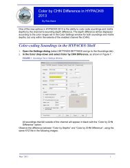
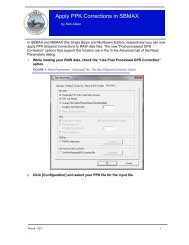
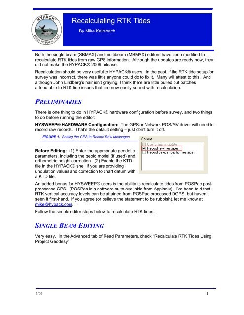
HYSWEEP® HARDWARE Configuration: The GPS or Network POS/MV driver will need to<br />
record raw records. That’s the default setting – just don’t turn it off.<br />
FIGURE 1. Setting the GPS to Record Raw Messages<br />
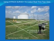
Before Editing: (1) Enter the appropriate geodetic<br />
parameters, including the geoid model (if used) and<br />
orthometric height correction. (2) Enable the KTD<br />
file in the HYPACK® shell if you are providing<br />
undulation values and correction to chart datum with<br />
a KTD file.<br />
An added bonus for HYSWEEP® users is the ability to recalculate tides from POSPac postprocessed<br />
GPS. (POSPac is a software suite available from Applanix). I’ve been told that<br />
<strong>RTK</strong> vertical accuracy levels can be attained from POSPac processed DGPS, but haven’t<br />
seen it first-hand. If you agree (or believe the statement to be rubbish), let me know at<br />
mike@hypack.com.<br />
Follow the simple editor steps below to recalculate <strong>RTK</strong> tides.<br />
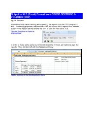
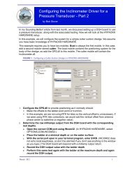
SINGLE BEAM EDITING<br />
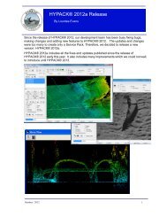
Very easy. In the Advanced tab of Read Parameters, check “Recalculate <strong>RTK</strong> <strong>Tides</strong> Using<br />
Project Geodesy”.<br />
3/09 1
FIGURE 2. <strong>Recalculating</strong> <strong>RTK</strong> <strong>Tides</strong> in the SINGLE BEAM EDITOR<br />
MULTIBEAM EDITING<br />
Although you edit HYSWEEP® HSX<br />
or HS2 files for multibeam, detailed<br />
GPS information is saved in<br />
HYPACK® RAW files. So to<br />
recalculate <strong>RTK</strong> tides, you will need<br />
RAW files. That’s usually not a<br />
problem, as the RAW files are<br />
recorded to the same folder containing<br />
the HSX files. If you copy an entire<br />
project, the RAW files come along.<br />
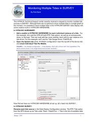
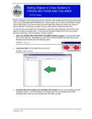
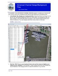
In the Raw Data phase of editing (edit<br />
phase 1):<br />
1. Select TOOLS- HYPACK RAW<br />
FILE ADJUSTMENTS.<br />
2. Choose the <strong>RTK</strong> <strong>Tides</strong> tab, then<br />
check on “Recalculate <strong>RTK</strong> <strong>Tides</strong><br />
Using Project Geodesy”.<br />
3. Select the device and optionally modify GPS antenna offsets.<br />
4. Click [Adjust] to recalculate tides.<br />
2
Another bonus! You may now load positions from the RAW file if that will improve the<br />
quality of your survey. Use the Positions tab.<br />
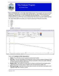
MULTIBEAM / POSPAC<br />
When using POSPac, the HYPACK®<br />
RAW files are not required for<br />
detailed GPS information. The<br />
POSPac .OUT file contains all the<br />
GPS anyone could ever use.<br />
Along with position, boat motion and<br />
heading refinements always made<br />
using POSPac adjustments, you can<br />
optionally select “Recalculate <strong>RTK</strong><br />
<strong>Tides</strong> Using Project Geodesy” to<br />
replace tides based on POSPac<br />
ellipsoidal elevations.<br />
3/09 3