Moisture Flux Convergence - Storm Prediction Center - NOAA
Moisture Flux Convergence - Storm Prediction Center - NOAA
Moisture Flux Convergence - Storm Prediction Center - NOAA

You also want an ePaper? Increase the reach of your titles
YUMPU automatically turns print PDFs into web optimized ePapers that Google loves.
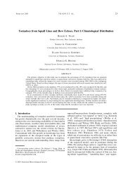
Fig. 1 Surface objective analysis valid at 1800 UTC on<br />
4 May 2003. Sea-level pressure (thick solid lines every<br />
2 mb), specific humidity (thin solid lines every 2 g kg -1 ).<br />
Shaded regions represent (a) the moisture advection<br />
term in MFC expression (10 -4 g kg -1 s -1 ), (b) the<br />
convergence term in MFC expression (10 -4 g kg -1 s -1 ),<br />
(c) the total moisture flux convergence (10 -4 g kg -1 s -1 ),<br />
and (d) the convergence of the total wind (10 -5 s -1 ). Lightto-dark<br />
(dark-to-light) shadings represent positive<br />
(negative) values. Pennant, barb, and half-barb<br />
represent wind speeds of 25, 5, and 2.5 m s −1 ,<br />
respectively.<br />
dryline and warm front. An attendant strong 500-hPa<br />
short-wave trough was moving eastward from Colorado<br />
and New Mexico into the central plains states at this<br />
time (not shown). The upper-level forcing combined<br />
with low-level moisture and instability resulted in the<br />
development of isolated supercells beginning around<br />
1815 UTC near the warm front in northeastern Kansas.<br />
Initiation of additional supercellular storms then<br />
occurred between 1900–2100 UTC, southward from the<br />
warm front along the convergence axis from<br />
southeastern Kansas into north-central Texas, just east<br />
of the dryline.<br />
Negative moisture advection (–2 to –6x10 -4 g kg -1 s -1 ) is<br />
observed west of the progressive dryline, but positive<br />
areas of moisture advection of the same magnitude<br />
occur in only very small areas near the warm front in<br />
eastern Kansas and along the cold front in west-central<br />
Kansas (Fig. 1a). The convergence term (Fig. 1b) is<br />
most coherent near the surface low, along the warm<br />
front, and along the cold front in western Kansas and<br />
eastern Colorado. The convergence term is also large<br />
along the dryline (Fig. 1b). The convergence term is<br />
relatively effective in highlighting the boundaries of<br />
interest, with small-scale features (or noise from the<br />
RUC first guess) dominating elsewhere across the<br />
analysis domain. The surface MFC largely reflects the<br />
convergence term, with the exception of the strong<br />
negative area west of the dryline (cf. Figs. 1c and 1b).<br />
The scaling arguments suggest that surface MFC<br />
can serve as an effective tool to detect mesoscale<br />
boundaries. However, surface convergence can serve<br />
the same purpose since it largely determines the<br />
surface MFC field. Forecasters may wish to compare<br />
MFC with convergence in convective situations to see<br />
these similarities.<br />
5. CONCEPTUALIZED VARIATIONS OF CI

![NSWW_ROC_Overview.ppt [Read-Only] - Storm Prediction Center ...](https://img.yumpu.com/26478320/1/190x146/nsww-roc-overviewppt-read-only-storm-prediction-center-.jpg?quality=85)


![NEW_PRODUCTS_imy.ppt [Read-Only] - Storm Prediction Center ...](https://img.yumpu.com/26478296/1/190x146/new-products-imyppt-read-only-storm-prediction-center-.jpg?quality=85)