Book 2 | Planning and Management - WSUD
Book 2 | Planning and Management - WSUD
Book 2 | Planning and Management - WSUD

Create successful ePaper yourself
Turn your PDF publications into a flip-book with our unique Google optimized e-Paper software.
flood retarding<br />
Flow rate<br />
Water Sensitive Urban Design<br />
3. Developed, with<br />
flood retarding<br />
1. Natural<br />
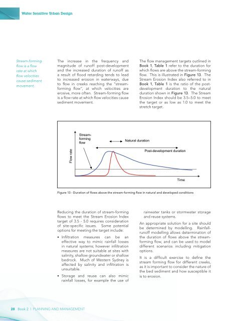
Stream-forming<br />
flow is a flow<br />
rate at which<br />
flow velocities<br />
cause sediment<br />
movement.<br />
The increase in the frequency <strong>and</strong><br />
magnitude of runoff post-development<br />
<strong>and</strong> the increased duration of runoff as<br />
a result of flood retarding tends to lead<br />
to increased erosion in waterways, due<br />
to flow in creeks reaching the “streamforming<br />
flow”, at which velocities are<br />
erosive, more often. Stream-forming flow<br />
is a flow rate at which flow velocities cause<br />
sediment movement.<br />
The flow management targets outlined in<br />
<strong>Book</strong> 1, Table 1 refer to the duration for<br />
which flows are above Time the stream-forming<br />
flow. This is illustrated in Figure 13. The<br />
Stream Erosion Index also referred to in<br />
<strong>Book</strong> 1, Table 1 is the ratio of the postdevelopment<br />
duration to the natural<br />
duration shown in Figure 13. The Stream<br />
Erosion Index should be 3.5–5.0 to meet<br />
the target or as low as 1.0 to meet the<br />
stretch target.<br />
Streamforming<br />
flow<br />
Natural duration<br />
Flow rate<br />
Post-development duration<br />
Time<br />
Figure 13 - Duration of flows above the stream-forming flow in natural <strong>and</strong> developed conditions<br />
Reducing the duration of stream-forming<br />
flows to meet the Stream Erosion Index<br />
target of 3.5 - 5.0 requires consideration<br />
of site-specific issues. Some potential<br />
options for meeting the target include:<br />
••<br />
Infiltration measures can be an<br />
effective way to mimic rainfall losses<br />
in natural systems; however infiltration<br />
measures are not suitable at sites with<br />
salinity, shallow groundwater or shallow<br />
bedrock. Much of Western Sydney is<br />
affected by salinity <strong>and</strong> infiltration is<br />
unsuitable.<br />
••<br />
Storage <strong>and</strong> reuse can also mimic<br />
rainfall losses, for example the use of<br />
rainwater tanks or stormwater storage<br />
<strong>and</strong> reuse systems.<br />
An appropriate solution for a site should<br />
be determined by modelling. Rainfallrunoff<br />
modelling allows determination of<br />
the duration of flows above the streamforming<br />
flow, <strong>and</strong> can be used to model<br />
different scenarios including mitigation<br />
options.<br />
It is a difficult exercise to define the<br />
stream forming flow for different creeks,<br />
as it is important to consider the nature of<br />
the bed sediment <strong>and</strong> how susceptible it<br />
is to erosion.<br />
28 <strong>Book</strong> 2 | planning <strong>and</strong> management