

Ore Bin / Oregon Geology magazine / journal - Oregon Department ...
Ore Bin / Oregon Geology magazine / journal - Oregon Department ...
Ore Bin / Oregon Geology magazine / journal - Oregon Department ...

Create successful ePaper yourself
Turn your PDF publications into a flip-book with our unique Google optimized e-Paper software.
Figure 23. Sheet-j100d deposits in the<br />
dark sands of Ihe Deschules Formarion display<br />
low-angle cross-bedding and marrixsupported<br />
pehhle conglomemles.<br />
They develop when a high discharge of water carries<br />
a sedimem load imennediate between a debris<br />
flow and normal SlTeam flow. Such a<br />
"hypercOl1centrated flood flow" would contain between<br />
40 and 80 weight percent as sediment and<br />
the remainder as fluid (water). Such flows would<br />
be turbulent. and grain·on-grain suppon would be<br />
imponant for the transponation and continued suspension<br />
of panicles. llIese flows are more fluid<br />
than debris flows or lahars. They are abundant<br />
in the Deschutes Formation.]<br />
[Two priocipal types of sedimems result from<br />
hypercoocentrated flood flows. The first is a clastsupponed,<br />
roonnally graded conglomer-dte (Figure<br />
24). These rocks may grade upward into horizontal<br />
bedding. llIe second. in lower velocity flows. is<br />
a thinly bedded. coarse sandstone that displays<br />
a wide range orclast si1.e (poor sorting) and usually<br />
grades continuously inlO the beds below and<br />
above.)<br />
[Debris-flow deposits]<br />
[Unsoned. usually very coarse-grained. matrix-supponed<br />
deposits that were transponed at<br />
high rocl:/water ratios are tenned "debris flows"<br />
(Figure 25). This term encompasses fluvial.<br />
mudflow-type deposits as well as flows more<br />
closely linked to volcanism (lahars).<br />
Some of these units within the Deschutes FormaTion.<br />
such as The Tetherow debris flow. are spectacular.<br />
containing clasts more than 6 ft (1.8 m)<br />
in diameter. Many grade laterally into finer grained<br />
rocks. Debris·flow deposiTS are increasingly rare<br />
toward the east in The DeSChutes Formation.)<br />
Figure 25. Dehris·f1ow deposit.<br />
Deschllte.~ Formation. near Stee/head Falls.<br />
PLIOCENE VOLCANISM IN THE<br />
DESCHUTES BASIN<br />
What stopped this deposition and returned<br />
the Deschutes to its canyon-cutting glory was.<br />
literally, the downfall of the Cascades. For<br />
reasons not fully understood, about 4 m.y.<br />
ago, the volcanoes of <strong>Ore</strong>gon began to subside<br />
into a downfaulted struCture called the<br />
High Cascade graben (Figure 26). Eruptive<br />
activity remained vigorous, although perhaps<br />
not as explosive as before. However, because<br />
the rising east wall of the graben fonned<br />
a barrier to eastward transport of volcanic<br />
debris, products of the late Pliocene eruptions<br />
were trapped in the graben and never reached<br />
the Deschutes drainage.<br />
Because little of the river"s energy was<br />
needed to carry debris erupted from these<br />
sinking volcanoes, the Deschutes could now<br />
go to work. downcuning and exposing its<br />
history.<br />
Several volcanic centers to the southeast-most<br />
notably Grass Bune near Prineville-erupted<br />
diktylaxitic basalts that<br />
flowed mostly westward into the Deschutes<br />
Basin. Basalts from these low shield volcanoes<br />
fonn the rimrock at Tendxmne and<br />
Plio- Pleistocene/<br />
basalts<br />
much of the high, rock-strewn plateau between<br />
Redmond, Terrebonne. Powell Bune,<br />
and Prineville. The age of these flows is 3.4<br />
m.y. (Smith, 1 986a). Pleistocene basalts also<br />
cover much of the area between Redmond<br />
and Prineville.<br />
East of the High Cascade graben, relatively<br />
small quantities of basalts were<br />
erupted, fonning low shield volcanoes orcinder<br />
cones. Squawback Ridge and Link<br />
Squaw Back, east of Green Ridge. are 2.9-<br />
m.y.-old shield volcanoes built by these eruptions.<br />
Two million years ago, the Deschutes<br />
Riverdrained northward along achannel similar<br />
in location to the canyons we see today.<br />
The course of the old river cut through a<br />
semiarid plain, incising a canyon through the<br />
volcanic layer cake. By 2 m.y. ago, the canyons<br />
were nearly as deep as we see them<br />
today.<br />
PLEISTOCENE INTRA CANYON<br />
BASALTS<br />
Intracanyon basalt flows from NeWberry<br />
volcano and the rising Cascades flowed<br />
through and filled the Deschutes, Metolius,<br />
and Crooked Riverchannels from 1.6 million<br />
to less than 700,000 years ago.<br />
The most voluminous of these intracanyon<br />
flows, dated at about 1.2 m.y.,<br />
came from the vicinity of Newberry volcano<br />
and followed the Crooked River canyon from<br />
O'Neil northward to the present location of<br />
Round Bune Dam (Smith, 1 986a). At least<br />
15 of these intracanyon flows were erupted<br />
in rapid succession. They fonn the distinctive<br />
intracanyon bench that extends along the<br />
Crooked Riverfrom the approximate location<br />
of Smith Rock State Park northward through<br />
Cove Palisades State Park (Figure 27). These<br />
basalts also fonn "The Island," a stark., flat-<br />
Pleistocene - Recent volcano<br />
DESCHUTES<br />
t<br />
volcanic<br />
dominated<br />
FORMATION<br />
I<br />
sediment<br />
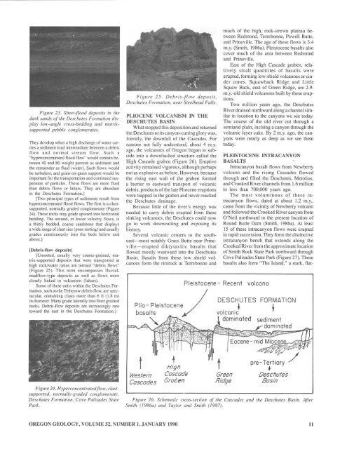
Figure 24. HyperCOIICemratedj7ow. clast·<br />
suppoJ"/ed. normally·graded conglomemte.<br />
Deschutes Formarion. COI'e Palisades Stare<br />
Park.<br />
t<br />
Western<br />
Cascades<br />
t<br />
HIgh<br />
Cascade<br />
Graben<br />
Green<br />
RIdge<br />
pre-Tertiary /<br />
~<br />
Deschutes<br />
Bosin<br />
Figllre 26. Schematic ao.n-seclion of Ihe Cascades and the Deschlltes Basill. Afler<br />
Smith (/986a) alld Tay/or and Smith (1987).<br />
OREGON GEOLOGY, VOLUME 52, NUMBER I,JANUARY 1990<br />
II


