

D'Aguilar Range parks guide - Department of National Parks ...
D'Aguilar Range parks guide - Department of National Parks ...
D'Aguilar Range parks guide - Department of National Parks ...

You also want an ePaper? Increase the reach of your titles
YUMPU automatically turns print PDFs into web optimized ePapers that Google loves.
Courtesy <strong>of</strong> Jason Flesser<br />
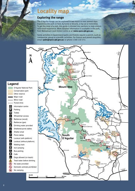
Locality map<br />
Exploring the range<br />
The D’Aguilar <strong>Range</strong> can be explored in two hours or over several days.<br />
Experience the park on foot, by horse or bicycle, or by car or motorbike.<br />
To get the most <strong>of</strong> a visit, this <strong>guide</strong> is divided into sections to help visitors<br />
tailor their experience. More detailed information is available in the park,<br />
from Walkabout Creek Visitor Centre or at .<br />
Some activities in Queensland <strong>parks</strong> and forests require a permit, such as<br />
commercial, group or scientific activities. For licence and permit enquiries,<br />
email or phone 1300 130 372.<br />
To Nanango<br />
D’AGUILAR<br />
N<br />
Esk<br />
Kilcoy<br />
Lake<br />
Somerset<br />
Neurum<br />
Archer<br />
campground<br />
Rasmussen<br />
Road<br />
22<br />
Road<br />
Delaney Creek<br />
20 Broadwater<br />
D’Aguilar<br />
Road<br />
Woodford<br />
Mount<br />
HIGHWAY<br />
To<br />
Nambour<br />
BRUCE<br />
Legend<br />
D’Aguilar <strong>National</strong> Park<br />
Conservation park<br />
Other reserve<br />
Major road<br />
Minor road<br />
Forest drive<br />
Information centre<br />
Parking<br />
Toilets<br />
Wheelchair access<br />
Barbecue (wood)<br />
Barbecue (gas)<br />
Drinking water provided<br />
Sheltered picnic tables<br />
Shelter shed<br />
Picnic tables<br />
Lookout (with platform)<br />
Lookout (without platform)<br />
Walking track<br />
4x4 camping<br />
Bus parking<br />
Cafe<br />
Dogs allowed (on leash)<br />
Treat water before drinking<br />
No water provided<br />
Domestic animals prohibited<br />
No camping<br />
To Esk<br />
Kilcoy<br />
Road<br />
Somerset<br />
Wivenhoe<br />
To Esk<br />
Somerset<br />
Lake<br />
Wivenhoe<br />
Falls lookout<br />
and Bulls Falls<br />
Somerset<br />
lookout<br />
Road<br />
BRISBANE VALLEY HIGHWAY<br />
White and<br />
Red Cedar<br />
Fernvale<br />
To Toowoomba<br />
Scale<br />
0 5 10 15 20 km<br />
17<br />
Mount Mee<br />
12<br />
Rocky Hole<br />
19 Neurum Creek<br />
21 campground<br />
18<br />
The Gantry<br />
16<br />
Sellin<br />
Road<br />
Northbrook<br />
Laceys<br />
11<br />
Wivenhoe<br />
outlook<br />
South<br />
D’Aguilar<br />
Parkway<br />
Maiala<br />
10<br />
Mount Glorious<br />
Westridge<br />
outlook 9<br />
Manorina<br />
8<br />
Mount<br />
Nebo<br />
Lake<br />
Manchester<br />
13<br />
WARREGO<br />
Mee<br />
Road<br />
Mount Mee<br />
Mount<br />
Mount<br />
Lake<br />
Manchester<br />
Lake Manchester<br />
Kholo<br />
Mount Brisbane Road<br />
Creek<br />
Road<br />
HIGHWAY<br />
Mee<br />
Road<br />
Crosby<br />
Road<br />
Road<br />
Boombana 7 6<br />
Mount<br />
Mount<br />
Glorious<br />
Dayboro<br />
Jollys<br />
Lookout<br />
Mount<br />
Samson<br />
Nebo<br />
Winn<br />
Road<br />
McAfees lookout<br />
Bunyaville<br />
Samford Conservation<br />
Samford<br />
Conservation Park<br />
Park<br />
15<br />
14<br />
Road<br />
Camp<br />
Mountain<br />
5<br />
lookout<br />
Road<br />
Gold<br />
Creek<br />
Reservoir<br />
Road<br />
Clear<br />
Mountain<br />
Conservation Park<br />
4<br />
Caboolture<br />
Road<br />
Lake<br />
Samsonvale<br />
Road<br />
Samford<br />
HIGHWAY<br />
Old Northern<br />
Bellbird<br />
Grove<br />
3<br />
Walkabout Creek<br />
2<br />
Enoggera<br />
Reservoir<br />
Moggill<br />
Conservation Park<br />
Moggill<br />
Road<br />
Gap Creek<br />
Road<br />
Dayboro<br />
Samsonvale<br />
Road<br />
Mt Coot-tha<br />
1<br />
WESTERN<br />
Road<br />
Waterworks<br />
FREEWAY<br />
Petrie<br />
Gympie Road<br />
Road<br />
Road<br />
To Brisbane<br />
To<br />
Brisbane<br />
To Brisbane<br />
2


