

D'Aguilar Range parks guide - Department of National Parks ...
D'Aguilar Range parks guide - Department of National Parks ...
D'Aguilar Range parks guide - Department of National Parks ...

Create successful ePaper yourself
Turn your PDF publications into a flip-book with our unique Google optimized e-Paper software.
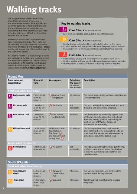
Walking tracks<br />
The D’Aguilar <strong>Range</strong> <strong>of</strong>fers a wide variety<br />
<strong>of</strong> walking tracks suitable for beginner<br />
and experienced walkers. Walking tracks are<br />
classified according to Australian Standards<br />
and are only suitable for pedestrian use.<br />
Please note that while each track is classified<br />
according to its most difficult section, other<br />
sections may be easier.<br />
Walkers can also access a number <strong>of</strong> forest<br />
trails throughout the range. These trails may<br />
be shared by horse and mountain bike riders,<br />
four-wheel-drivers and/or motorcyclists—please<br />
see the trail map section <strong>of</strong> this <strong>guide</strong> (pages 6<br />
and 7) for more details.<br />
Mt Coot-tha Forest has a diverse range <strong>of</strong> tracks<br />
and trails, picnic facilities and seasonal creeks<br />
and waterfalls to explore. For information on<br />
walking tracks in Mt Coot-tha Forest, please<br />
refer to the track map on the Brisbane City<br />
Council website .<br />
Key to walking tracks<br />
Class 2 track Australian Standards<br />
• Easy level, well-graded track, suitable for all fitness levels.<br />
Class 3 track Australian Standards<br />
• Gently sloping, well-defined track with slight inclines or few steps.<br />
• Caution needed on loose gravel surfaces and exposed natural lookouts.<br />
• Reasonable level <strong>of</strong> fitness and ankle-supporting footwear required.<br />
Class 4 track Australian Standards<br />
• Distinct track, usually with steep exposed inclines or many steps.<br />
• Caution needed on loose gravel surfaces and exposed natural outlooks.<br />
• Moderate level <strong>of</strong> fitness and ankle-supporting footwear required.<br />
Mount Mee<br />
Track name and<br />
classification<br />
Distance/<br />
Time<br />
Short walks (less than 1 hour)<br />
Lophostemon walk<br />
750 m circuit,<br />
allow 20<br />
minutes<br />
Access point<br />
21<br />
Neurum Creek<br />
campground<br />
Drive from<br />
The Gantry<br />
(90 minutes<br />
from Brisbane)<br />
Description<br />
15 minutes This circuit begins at the northern end <strong>of</strong> Neurum<br />
Creek campground.<br />
Piccabeen walk<br />
1 km circuit,<br />
allow 20–30<br />
minutes<br />
16<br />
The Gantry<br />
Not<br />
applicable<br />
This short walk is along a boardwalk and track<br />
through a lush piccabeen palm grove.<br />
Falls lookout track<br />
1 km return,<br />
allow 20–30<br />
minutes<br />
18<br />
Falls lookout<br />
and Bulls Falls<br />
5 minutes Falls lookout can be reached by a gravel road<br />
<strong>of</strong>f Neurum Creek Road and has a short walk<br />
down to a viewing platform overlooking the<br />
northern side <strong>of</strong> D’Aguilar <strong>Range</strong> and<br />
picturesque Neurum Valley.<br />
Mill rainforest walk<br />
1.4 km circuit,<br />
allow 40–50<br />
minutes<br />
Off Neurum Creek<br />
Road between<br />
The Gantry 16<br />
and Neurum Creek<br />
campground 21<br />
10 minutes This subtropical rainforest track provides<br />
great opportunities for birdwatching so bring<br />
binoculars. The track entrance is accessed by<br />
a short unsealed, formed gravel road.<br />
Longer walks (2–4 hours)<br />
Somerset trail<br />
13 km circuit,<br />
allow 4 hours<br />
16<br />
The Gantry<br />
Not<br />
applicable<br />
This track passes through scribbly gum forests,<br />
rainforest and dry open forest. Take in views<br />
to the west overlooking Somerset Dam and<br />
Lake Wivenhoe.<br />
South D’Aguilar<br />
Short walks (less than 2 hours)<br />
Tree discovery<br />
circuit<br />
650 m circuit,<br />
allow 15<br />
minutes<br />
15<br />
Bunyaville<br />
Conservation<br />
Park<br />
20 minutes This walking track starts and finishes at the<br />
northern end <strong>of</strong> the day-use area.<br />
8<br />
Atrax circuit<br />
750 m return,<br />
allow 15–20<br />
minutes<br />
8<br />
Manorina 30 minutes Walk through tall forest featuring cabbage<br />
tree palms.


