

D'Aguilar Range parks guide - Department of National Parks ...
D'Aguilar Range parks guide - Department of National Parks ...
D'Aguilar Range parks guide - Department of National Parks ...

You also want an ePaper? Increase the reach of your titles
YUMPU automatically turns print PDFs into web optimized ePapers that Google loves.
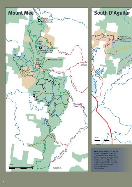
Lovedays Road<br />
Top Road<br />
Mount Mee<br />
Rasmussen Road<br />
22<br />
!<br />
20<br />
Archer<br />
campground<br />
Broadwater<br />
South D’Aguilar<br />
Lovedays Road<br />
L Traverse<br />
12 Red Cedar<br />
Centipede<br />
19<br />
!<br />
Rocky<br />
Hole<br />
Road<br />
12 White Cedar<br />
Mount Mee forest drive<br />
Neurum Creek Road<br />
21<br />
Neurum Creek<br />
campground<br />
Settlement Road<br />
Western escarpment forest drive<br />
17<br />
!<br />
Somerset<br />
lookout<br />
Falls<br />
lookout<br />
and<br />
Bulls Falls<br />
18<br />
!<br />
16<br />
!<br />
!<br />
Mill rainforest walk<br />
The Gantry<br />
Sellin Road<br />
To Mount Mee<br />
and <strong>D'Aguilar</strong><br />
Wivenhoe–Somerset Road<br />
Peggs Road<br />
The Hanger<br />
Mt Mee Road<br />
A Break<br />
Chambers Road<br />
Diana's Bath<br />
car park<br />
Diana's Bath Road<br />
Byron Creek Road<br />
Centre Road<br />
drive<br />
Mt Brisbane Road<br />
Jacky Creek Road<br />
Jacky<br />
Creek<br />
<strong>Range</strong> Road forest<br />
Butchershop Creek Road<br />
May Creek Road<br />
Scale<br />
0<br />
2 4 km<br />
Scale<br />
0<br />
2 4 km<br />
<strong>Range</strong> Road forest drive<br />
Wirth Road<br />
Laceys Creek Road<br />
Map adjoins top <strong>of</strong><br />
South <strong>D'Aguilar</strong> map<br />
Note: Many trails lead to private<br />
property. Get permission from<br />
landholders before accessing<br />
private property. Many gates are<br />
locked and cannot be opened.<br />
It is the responsibility <strong>of</strong> riders<br />
and walkers to determine<br />
appropriate access<br />
requirements.<br />
6


