Phoenix Park Conservation Management Plan Appendices
Phoenix Park Conservation Management Plan Appendices
Phoenix Park Conservation Management Plan Appendices

Create successful ePaper yourself
Turn your PDF publications into a flip-book with our unique Google optimized e-Paper software.
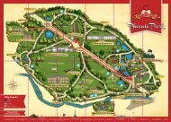
The <strong>Phoenix</strong> <strong>Park</strong> including the Deer <strong>Park</strong>, Recreational Areas and Monuments<br />
Area Name Current use and facilities Historical name and use Description<br />
Khyber Road valley A link between Islandbridge Gate and<br />
Chesterfield Avenue currently closed to traffic<br />
part way along. Vehicles use the adjacent<br />
open areas for informal parking and to allow<br />
access to the sports fields to east and west.<br />
This former meltwater valley provides a sweeping alignment and gentle gradients for the drive known as Khyber Rd. which climbs from Islandbridge<br />
Gate in the south by the River Liffey and Acres Road in the north. The small valley cuts down below the plateau of the <strong>Park</strong> to create a landscape<br />
which is separated from the outside by the landform and 19th century plantations. The bold rounded blocks of trees are placed so that they provide<br />
narrow vistas up the sides of the valley on alternating sides. Closure of this road to through traffic has created an attractive naturalistic landscape setting<br />
for pedestrians and cyclists with a stream running in close proximity to the road. The route appears well, but is not intensively used.<br />
Military Road Provides routes to the playing fields and<br />
pavilions but not to through traffic.<br />
Also called the Corkscrew Road and Serpentine<br />
Road.<br />
This area of naturalistic landscape dominated by the Military Road is formed on steeply sloping river terraces on the north side of the Liffey Valley.<br />
The land is predominantly for amenity with low intensity use and low levels of maintenance. The Military Road which had received a lot of through<br />
traffic has been closed. The Military Road is one of the more picturesque routes through the <strong>Park</strong> providing an important sequence of views out to<br />
the River Liffey and south and east to the city and to the Wicklow Mountains.<br />
Fifteen Acres (west) Large area primarly used by the herd of Fallow<br />
Deer and also used for informal activities<br />
such as walking and running. It also facilitates<br />
the flying of model aircraft.<br />
The Fifteen Acres was used extensively for<br />
military use and training in the 19th century.<br />
The eastern portion of this area once contained<br />
gun batteries and military targets.<br />
This vast, generally flat, open area of mown grassland is characterised by the mature plantations that line its fringes. The space is so large that any<br />
activity in the area seems dwarfed. Early indications are that this area may contain a number of unexplored archaeological sites.<br />
Papal Cross Paved areas and monument erected for the<br />
Papal visit in 1979.<br />
This area was historically a part of the Fifteen<br />
Acres.<br />
This modern intervention in the <strong>Park</strong> is a monument designed as a setting for a visit to Ireland in September 1979 by Pope John Paul II. The Cross<br />
formed the focal point for an open air mass attended by over 1 million people.<br />
Chapelizod Slopes (part Military Road/ St<br />
Mary’s Rd/lower part of Glen Rd)<br />
<strong>Plan</strong>tations and grassland with informal use. Camp Ground with some land given over to<br />
gravel pits and quarries. Areas immediately<br />
east of the Chapelizod Gate are shown in<br />
the 1830 map of Decimus Burton as being a<br />
formally arranged garden (Kings Garden).<br />
Relatively steeply sloping, grassed south facing slopes dropping from the elevated plateau of the <strong>Park</strong> down the river terraces to the <strong>Park</strong> wall. The<br />
lower ground contains the perimeter plantations as well as the Chapelizod Gate and entry drives. The Military Road crosses the space on a straight<br />
alignment directly towards the front of the former Royal Hibernian Military School.<br />
Glen Road Predominantly steep planted slopes through<br />
which the Military Road passes. The upper<br />
slopes blend into the Fifteen Acres.<br />
Not named, but some land given over to<br />
gravel pits .<br />
Steeply sloping grassed south west facing slopes dropping from the elevated plateau of the <strong>Park</strong> down to the <strong>Park</strong> wall. The lower ground contains<br />
the perimeter plantations. The Glen Road traverses the mid-slope through a landscape dominated by mature deciduous trees and overlooked by the<br />
Knockmary Lodge and Knockmary Cemetery Mound which also forms a prominent feature of the area sited at the top of the slope<br />
Oldtown Wood area A substantial area of plantations and grassy<br />
glades among trees. Some picnic benches<br />
provided beside Furze Road.<br />
Oldtown Wood was once a large rectangular<br />
block of woodland with roundels of trees<br />
and crossed by a number of radiating rides.<br />
These have mostly been lost.<br />
A large area of mature deciduous plantations, open grassland and scattered small trees which are remnants of the former Oldtown Wood with some<br />
later planting. There is an experimental plot fenced to exclude deer in the south west corner of this area. Two of the radiating avenues, and a roundel,<br />
laid out in Oldtown Wood are still expressed in plantations to the south of Furze Road. The area appears to be well used for informal activity with<br />
some picnic benches provided alongside Furze Road.<br />
Knockmaroon Gate area A gate Lodge with two imposing vehicular<br />
and pedestrian entrances. Densely wooded<br />
slopes with drives providing access from<br />
the gate to Furry Glen and the remainder of<br />
the <strong>Park</strong>.<br />
Traditionally a <strong>Park</strong> entrance with gate<br />
Lodge. Also cartographic evidence of an<br />
‘Ice House’ and gravel pits in this area. Also<br />
Bakers Well adjacent to a small stream which<br />
feeds into the Glen Pond is to be found in<br />
this area.<br />
Sloping grassed and wooded south facing slopes dropping from the elevated land to the north and west to Knockmaroon Gate. <strong>Plan</strong>tations occupy<br />
much of the area. Some external features along Knockmaroon Hill are visible from higher ground. This is an area of steep slope and dense plantations.<br />
Lower Glen Road (Lower Furry Glen) Informal recreation along footpaths through<br />
the trees.<br />
Formerly contained Coyles Quarry which<br />
supplied large quantities of stone for <strong>Park</strong><br />
buildings in the 19th century now filled in.<br />
The name ‘Furry’ is thought to derive from<br />
the word ‘Furze’ bush (also known as gorse<br />
or ’ whin’ because of the large number grown<br />
on the embankments). Another name is the<br />
Fairy Glen, a name derived from the large<br />
number of Hawthorn trees in the area.<br />
Densely wooded valley with steeply sloping sides. The steep valley contains a stream which facilitates the overflow of the Furry Glen Lake and exits<br />
beneath the <strong>Park</strong> walls to the River Liffey.<br />
108<br />
THE PHOENIX PARK CONSERVATION MANAGEMENT PLAN