evacuate! - Ministry of Civil Defence and Emergency Management
evacuate! - Ministry of Civil Defence and Emergency Management
evacuate! - Ministry of Civil Defence and Emergency Management

You also want an ePaper? Increase the reach of your titles
YUMPU automatically turns print PDFs into web optimized ePapers that Google loves.
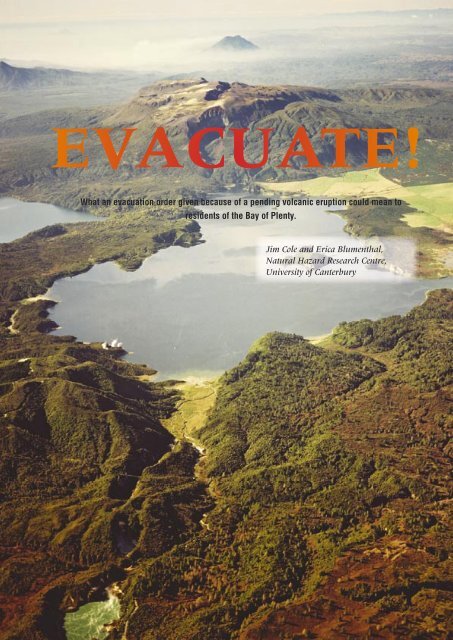
EVACUATE!<br />
What an evacuation order given because <strong>of</strong> a pending volcanic eruption could mean to<br />
residents <strong>of</strong> the Bay <strong>of</strong> Plenty.<br />
Jim Cole <strong>and</strong> Erica Blumenthal,<br />
Natural Hazard Research Centre,<br />
University <strong>of</strong> Canterbury<br />
46<br />
TEPHRA<br />
June 2004
In about 1315AD Tarawera volcano erupted with enormous<br />
force, depositing rhyolitic ash over much <strong>of</strong> the northern<br />
part <strong>of</strong> the North Isl<strong>and</strong>. This was the Kaharoa eruption.<br />
Columns <strong>of</strong> ash may have continued for days or weeks, <strong>and</strong><br />
these were followed by slow extrusion <strong>of</strong> lava domes, with<br />
intermittent ash eruptions, which may have continued for<br />
four years (Nairn et al., 2001). If such an event occurred<br />
today it would cause major disruption to the surrounding<br />
area, as indicated in Table 1. Evacuation <strong>of</strong> some areas will<br />
be inevitable.<br />
The distribution <strong>of</strong> ash will largely depend on<br />
the wind direction at the time <strong>of</strong> the eruption, <strong>and</strong> in an<br />
eruption <strong>of</strong> this magnitude wind direction will change<br />
several times. In the 1315 Kaharoa eruption, ash first<br />
travelled southeastwards, <strong>and</strong> then northwestwards,<br />
covering an area from Northl<strong>and</strong> to Mahia Peninsula<br />
with a layer <strong>of</strong> ash, with the greatest thickness occurring<br />
between Tauranga <strong>and</strong> Murupara (Fig 1). The dominant<br />
high level wind direction is from the west, therefore<br />
areas to the east <strong>of</strong> the volcano are more likely to be<br />
covered with ash, even small amounts <strong>of</strong> which will<br />
cause severe disruption to all forms <strong>of</strong> transportation<br />
(Table 2).<br />
EVACUATION ZONES<br />
The next eruption <strong>of</strong> this type in the Bay <strong>of</strong><br />
Plenty will most probably be from Tarawera or from<br />
Haroharo volcano to the north. When this happens,<br />
Thickness<br />
<strong>of</strong> ash<br />
0-2mm<br />
2-20mm<br />
Effects on roads<br />
Road markings obscured, traction reduced (wet <strong>and</strong><br />
dry ash), visibility reduced as dry ash is remobilised<br />
by traffic <strong>and</strong> wind. Steep hills difficult for 2WD<br />
vehicles to climb.<br />
Moderate hills become difficult for 2WD vehicles<br />
to climb, steep hills impossible. Drifts cause larger<br />
humps in road. Once dampened <strong>and</strong> compacted it<br />
becomes firmer, easier to drive on.<br />
Fig 1. Proximal distribution <strong>of</strong> Kaharoa ashfall deposits; isopach<br />
values in cms (from Johnston et al. 2002)<br />
the highest risk is within a 10km zone around the vent<br />
area, <strong>and</strong> this becomes a Primary Evacuation Zone (Fig<br />
2), including the Rotorua Lakes district (bordering Lakes<br />
Rotokakahi, Tikitapu, Okareka, Tarawera <strong>and</strong> Okataina).<br />
Residents <strong>of</strong> this area would have to be <strong>evacuate</strong>d prior<br />
to commencement <strong>of</strong> the eruption.<br />
Residents on the north shore <strong>of</strong> Lake Tarawera<br />
(along Spencer Road) would be the most vulnerable<br />
to any eruption from Tarawera (Fig 3). This area is<br />
likely to be completely devastated in a Kaharoa-type<br />
eruption from Tarawera or Haroharo, particularly from<br />
ballistic ejecta <strong>and</strong> thick near-vent ashfalls. Therefore,<br />
it is imperative that this area <strong>evacuate</strong>s pre-eruption.<br />
An added problem is the single evacuation route into<br />
<strong>and</strong> out <strong>of</strong> the area. Spencer Road ends at the edge <strong>of</strong><br />
20-100mm<br />
100-<br />
300mm<br />
Slight inclines may be impassable to 2WD vehicles,<br />
4WD vehicles need differential or hub locks to climb<br />
moderate hills. Larger drifts (eg 300mm) may hinder<br />
or stop 2WD vehicles on flat roads.<br />
Uneven surfaces in the ash stop any 2WD vehicles,<br />
compacted damp ash on flat surfaces is still able to<br />
be driven on. 4WD utility type vehicles (not cars) may<br />
be able to slowly progress on the flat. Drifts may need<br />
to be cleared. Moderate inclines difficult, but may be<br />
possible for experienced 4WD drivers. Steep inclines<br />
generally impassable. Ruts easily formed on hills.<br />
>300mm<br />
Compacted ash may be driven on by 4WD vehicles,<br />
s<strong>of</strong>ter patches may easily bog vehicles. Gradual<br />
inclines possible on compacted ash, but after a few<br />
vehicles, ruts in the ash will form, hindering uphill<br />
progress for further vehicles.<br />
Table 2. Ashfall effects on road transportation (from Barnard, 2003)<br />
Fig 2. Evacuation Zones: Zone 1 = 10km radius (primary) zone;<br />
Zone 2 = 40km radius (secondary) zone; Zone 3 = 100km radius<br />
(potentially 'unsafe') zone.<br />
A view looking northeast along the vents <strong>of</strong> the 1886 AD eruption, from Frying Pan Lake in the foreground<br />
to Mt. Tarawera <strong>and</strong> in the background, the cone <strong>of</strong> Mt Edgecumbe. Photo: GNS Lloyd Homer.<br />
47<br />
TEPHRA<br />
June 2004
Fig 3. Lake Tarawera area evacuation route. Spencer Road west to<br />
Tarawera Road to Rotorua.<br />
Fig 5. Kawerau Evacuation Routes. Two possible evacuation routes:<br />
NE via SH30; or south via the main road or the forestry road.<br />
Lake Tarawera <strong>and</strong> is a long narrow road that extends<br />
for ~17 km, from Tarawera Road to Rotorua, making<br />
large-scale evacuation on this road hazardous. There is<br />
also the likelihood <strong>of</strong> l<strong>and</strong>slips occurring on the road,<br />
associated with pre-eruption seismicity, severing the link<br />
to Rotorua. The construction <strong>of</strong> a loop road extending<br />
northwest from Spencer Road to Millar Road, Lake<br />
Okareka, should be considered. This would be <strong>of</strong> benefit<br />
to the local residents at any time, but particularly so<br />
if an eruption is imminent. The use <strong>of</strong> a loop road as<br />
a mitigation measure was implemented by <strong>of</strong>ficials at<br />
Mammoth Mountain (Long Valley, California, USA)<br />
during an eruption scare (Mader & Blair, 1987).<br />
The next level <strong>of</strong> risk will be inside a zone <strong>of</strong><br />
40 kms radius from the erupting volcano (Fig.2). This<br />
is the Secondary Evacuation Zone <strong>and</strong> would include<br />
the urban areas <strong>of</strong> Rotorua, Kawerau <strong>and</strong> Murupara.<br />
Effects on these towns will depend very much on the<br />
wind direction, but such variability puts all in potential<br />
danger. The larger population means that any decision<br />
to <strong>evacuate</strong> becomes a major operation <strong>and</strong> requires<br />
careful planning.<br />
Fig 4. Rotorua Evacuation Routes. Rotorua has two options: south by<br />
SH 30 or SH 5 to Taupo; or west by SH 5 to Hamilton.<br />
URBAN AREAS<br />
Rotorua is situated 25 km west-northwest <strong>of</strong><br />
Tarawera volcano (Fig 4). The population <strong>of</strong> Rotorua<br />
district is 64,473 (Census 2001), <strong>and</strong> a compulsory<br />
evacuation notice may be given if the eruption is large<br />
enough or wind direction is from the east. Because <strong>of</strong><br />
the larger population however, it would be advisable<br />
that voluntary evacuation is encouraged earlier, to<br />
decrease the number <strong>of</strong> potential evacuees where the<br />
compulsory order is given. The importance <strong>of</strong> the timing<br />
<strong>of</strong> any evacuation order is critical: too soon, <strong>and</strong> people<br />
will start to return, believing the emergency is over; too<br />
late, <strong>and</strong> many evacuees will try to <strong>evacuate</strong> at once,<br />
causing panic.<br />
Kawerau is situated 20 km northeast <strong>of</strong> Tarawera<br />
volcano (Fig 5), with a population <strong>of</strong> 6,975 (Census<br />
2001). Kawerau has three main road exits from its<br />
township. It must be remembered that Rotorua <strong>and</strong><br />
Te Teko could also have been ordered to <strong>evacuate</strong> at<br />
this time. This puts pressure on some roads <strong>and</strong> other<br />
evacuation routes.<br />
Population statistics <strong>of</strong> the potential evacuation<br />
areas are presented in Table 3. The percentage <strong>of</strong><br />
residents who actually <strong>evacuate</strong> is hard to estimate.<br />
A figure <strong>of</strong> 50-70% <strong>of</strong> the population, is presented by<br />
Auckl<strong>and</strong> Regional Council (1996) as the “anticipated<br />
maximum credible [evacuee] number” in the event<br />
<strong>of</strong> an eruption from the Auckl<strong>and</strong> volcanic field. This<br />
percentage is supported by Dow <strong>and</strong> Cutter (2002)<br />
who found there was an evacuation rate <strong>of</strong> 65% during<br />
Hurricane Floyd in the USA. Therefore, in Table 3, an<br />
estimated 60% <strong>of</strong> the affected Bay <strong>of</strong> Plenty region<br />
population is taken as a potential figure for numbers <strong>of</strong><br />
evacuees.<br />
Plans for evacuation movement, ie. major<br />
evacuation routes <strong>and</strong> destinations, must be in place<br />
48<br />
TEPHRA<br />
June 2004
ASHFALL IMPACT SCENARIO<br />
300mm (30cm) thickness<br />
All <strong>of</strong> the effects described above, with additional impacts such as:<br />
• Heavy kill <strong>of</strong> aquatic life in rivers <strong>and</strong> lakes.<br />
• Major collapse <strong>of</strong> ro<strong>of</strong>s due to ash loadings.<br />
• Loading <strong>and</strong> breakage <strong>of</strong> power <strong>and</strong> telephone lines.<br />
• Roads unusable until cleared.<br />
Associated Effects<br />
Ashfall has the potential to create additional problems for emergency services <strong>and</strong> other agencies. Some <strong>of</strong> these are:<br />
• Heavy dem<strong>and</strong>s for public information.<br />
• Difficulty <strong>of</strong> movement under ashfall conditions.<br />
• Need for protection <strong>and</strong> ‘ash-pro<strong>of</strong>ing’ <strong>of</strong> emergency service personnel, vehicles, plant, <strong>and</strong> communications<br />
systems.<br />
• Blanketing <strong>of</strong> road <strong>and</strong> street signage, numbers, road markings, hydrants, etc.<br />
• Possible lengthy duration <strong>of</strong> impacts.<br />
• Physical disposal.<br />
• Unfamiliar operational environment.<br />
• Uncertainty over future course <strong>of</strong> events.<br />
Table 1. Effects <strong>of</strong> ashfall (after Tauranga/WBOP District Councils, 2002)<br />
49<br />
TEPHRA<br />
June 2004
Location Population If Only 60% Evacuate<br />
Rotorua District 64,473 ~ 39,000<br />
Kawerau District 6,975 ~ 4,000<br />
Te Teko 630 ~ 400<br />
Te Puke 6,774 ~ 4,000<br />
Murupara 1,959 ~ 1,200<br />
Whakatane District 32,814 ~ 20,000<br />
Tauranga District 90,906 ~ 55,000<br />
Total 204,531 ~125,000<br />
Table 3. Populations <strong>and</strong> possible numbers <strong>of</strong> evacuees in the Bay<br />
<strong>of</strong> Plenty region (Census, 2001)<br />
well before any evacuation is necessary. Plans for<br />
hospitals, schools <strong>and</strong> nursing homes should already<br />
have been implemented by each authority, but<br />
individual facilities <strong>and</strong> institutions also need to have<br />
an evacuation plan. To achieve this, communication<br />
links must be established early in the pre-eruption stage.<br />
Locations <strong>of</strong> evacuation shelters should be confirmed<br />
<strong>and</strong> made accessible <strong>and</strong> known to agencies <strong>and</strong> the<br />
public. Vehicle protection, ash clearance, bulk ash<br />
disposal, contractor resources <strong>and</strong> arrangements, <strong>and</strong><br />
availability <strong>of</strong> fuel are also important. Lists <strong>of</strong> special<br />
equipment <strong>and</strong> supplies should be compiled, including<br />
tow trucks, <strong>and</strong> taxi/private bus companies. Plans<br />
for potential receiving cities need to be updated; the<br />
availability <strong>of</strong> fuel <strong>and</strong> suitable accommodation will<br />
need to be monitored prior to an event.<br />
EVACUATION ROUTE INFORMATION:<br />
The evacuation movement can be either preeruption<br />
or during-eruption. The primary method <strong>of</strong><br />
evacuation movement in this area has to be by road,<br />
although there is a rail link to Kawerau. Before the<br />
eruption, road conditions are unaffected by ash, but<br />
apprehension may affect driving skills. Evacuation<br />
movement during periods <strong>of</strong> ashfall, is drastically<br />
changed by road conditions, <strong>and</strong> therefore, the<br />
subsequent action taken by drivers. Under this scenario,<br />
most recommended <strong>and</strong> compulsory evacuations take<br />
place before any substantial ashfalls in the area.<br />
Viable destinations for evacuees from Rotorua<br />
include Hamilton, Auckl<strong>and</strong> <strong>and</strong> possibly Tauranga <strong>and</strong><br />
Taupo. However, evacuation to Tauranga <strong>and</strong> Taupo,<br />
or to any other city within the Bay <strong>of</strong> Plenty region,<br />
is better only as an interim measure. These centres<br />
could need to be <strong>evacuate</strong>d themselves if the eruption<br />
escalated or wind direction changed. If the route to<br />
Taupo is taken, the recommendation given to evacuees<br />
will be to travel south along SH 30 through to SH 1,<br />
as SH 5 passes close to the Primary Evacuation Zone<br />
<strong>and</strong> may be closed prior to the eruption. If the route<br />
to Hamilton is taken, the recommendation given to<br />
evacuees will be to travel via SH 5 to SH 1 (Fig 4).<br />
Clear advice needs to be given to the public,<br />
recommending evacuation routes <strong>and</strong> destinations (or<br />
destinations to avoid), well in advance <strong>of</strong> an evacuation<br />
warning.<br />
If the population leaves Kawerau via Kawerau<br />
Road to SH 30, the choice lies in either going to the west<br />
or east (along SH 30). The best option is to take SH 30 to<br />
the east (Fig 5); they could then travel to Te Teko, turn<br />
south <strong>and</strong> follow the south route <strong>and</strong> travel on to Taupo<br />
via Murupara; or could turn north from Te Teko, or to<br />
Matata, on the coast, <strong>and</strong> then northwest to Tauranga.<br />
Following this route would be slow, <strong>and</strong> would involve<br />
travelling in ashfall-prone areas, once the eruption<br />
has commenced. Going to the west will compound the<br />
problems in the Rotorua area.<br />
A second option is to leave Kawerau by the<br />
southern forestry road to Ngamotu Road, although<br />
this comes in close proximity to Tarawera volcano, just<br />
outside <strong>of</strong> the Primary risk zone. This option is only<br />
possible pre-eruption, <strong>and</strong> is likely to be closed as soon<br />
as the eruption begins. The options from here are east to<br />
Pokairoa Road, following it south to Kopuriki Road until<br />
Murupara, then turn west earlier to Rainbow Mountain<br />
<strong>and</strong> south to Taupo.<br />
EVACUATION BY ROAD<br />
This is likely to be the most common<br />
transportation method used in evacuations for the<br />
Rotorua-Kawerau districts. Most people will be advised<br />
to <strong>evacuate</strong> by car, except for a few minority groups<br />
who will neither be able to drive, nor be able to<br />
travel with friends <strong>and</strong> family. These include special<br />
population groups such as hospital patients, residential<br />
District<br />
Cars<br />
Rental<br />
cars<br />
Taxis<br />
Trucks<br />
Buses &<br />
coaches<br />
Trailers<br />
Motorcycles<br />
Mopeds<br />
Tractors<br />
Exempt<br />
vehicles<br />
Misc.<br />
Total<br />
Auckl<strong>and</strong> 625,590 11,329 3,497 94,595 3,088 71,746 9,187 828 2,530 1,325 3,972 827,687<br />
Hamilton 145,457 481 267 33,112 1,135 38,091 3,200 828 2,486 578 1,190 226,825<br />
Tauranga 92,357 321 129 20,395 506 22,715 2,340 610 1,184 546 1,159 142,262<br />
Rotorua 32,311 69 99 8,147 260 8,284 653 117 459 332 333 51,064<br />
Table 4. Vehicle numbers (registered) in the Bay <strong>of</strong> Plenty/Waikato/Auckl<strong>and</strong> regions (From L<strong>and</strong> Transport Safety Authority, 2000)<br />
50<br />
TEPHRA<br />
June 2004
schools (if there is need for a<br />
rapid evacuation), nursing homes<br />
<strong>and</strong> retirement villages. In these<br />
cases, it will be recommended that<br />
people travel on buses, but each<br />
organisation will need to meet<br />
their own evacuation procedures.<br />
Rotorua district has 32,311<br />
registered cars in the district<br />
(Table 4); 32,479 including rental<br />
cars <strong>and</strong> taxis, together with 260<br />
buses <strong>and</strong> coaches. Assuming a<br />
population <strong>of</strong> 64,473, the number<br />
<strong>of</strong> cars would appear to be<br />
adequate, assuming two people per<br />
car. For those without a household<br />
car, or without the opportunity<br />
to travel with friends or relations,<br />
they will need to rely on buses <strong>and</strong><br />
coaches. Measures must be taken<br />
to ensure these are organised in<br />
advance, with meeting points <strong>and</strong><br />
drivers prearranged.<br />
Census 2001 states that<br />
90.9% <strong>of</strong> households in the Bay<br />
<strong>of</strong> Plenty region have access to<br />
a motor vehicle. As there are<br />
86,793 households in the Bay <strong>of</strong><br />
Plenty, there are therefore 7,899 households without<br />
access. With an average household population (Bay <strong>of</strong><br />
Plenty region) <strong>of</strong> 2.6 persons, this will result in about<br />
20,535 people in the region without access to a motor<br />
vehicle. From these figures it appears that Rotorua has<br />
~6,420 people without access to a motor vehicle, while<br />
Kawerau District has ~939 people without access to a<br />
motor vehicle. The assumption is made that most <strong>of</strong> the<br />
7,359 people, from these key areas, will need public<br />
transport (Table 5).<br />
SECURITY OF EVACUATED AREA<br />
The security <strong>of</strong> the <strong>evacuate</strong>d area is intimately<br />
linked with authority <strong>and</strong> responsibility. It is extremely<br />
important that measures are taken to secure <strong>evacuate</strong>d<br />
areas, <strong>and</strong> that evacuees are aware that this will<br />
be done. The security <strong>of</strong> the <strong>evacuate</strong>d area is also<br />
important to continue sustainability <strong>of</strong> lifelines in the<br />
area, to encourage clean-up <strong>and</strong> return <strong>of</strong> evacuees after<br />
Kawerau, with a population <strong>of</strong> almost 7,000, lies 20km northeast <strong>of</strong><br />
Tarawera Volcano (out <strong>of</strong> picture to the right). In the background Lake<br />
Pupuwharu <strong>and</strong> Mt Edgecumbe. Photo: GNS Lloyd Homer.<br />
the event. During many past evacuations, (eg. Rabaul<br />
1994) looting <strong>and</strong> other negative socially destructive<br />
actions have occurred, by individuals <strong>and</strong> groups <strong>and</strong><br />
this must be avoided at all costs.<br />
RECOVERY<br />
Initial destinations for evacuees are likely to be<br />
Auckl<strong>and</strong>, Hamilton, Tauranga, <strong>and</strong> Taupo. However,<br />
many smaller destinations will receive evacuees, with<br />
many people wishing to choose their own destination<br />
because <strong>of</strong> relatives or friends. It is also possible that<br />
some <strong>of</strong> the cities (eg. Tauranga <strong>and</strong> Taupo) could<br />
need to be <strong>evacuate</strong>d themselves <strong>and</strong> are therefore not<br />
recommended as ideal final destination points.<br />
Evacuees should be advised to <strong>evacuate</strong> further<br />
than the ~100 km ‘unsafe’ radius from Tarawera<br />
volcano (Fig.2). After initial destinations have been<br />
Total number <strong>of</strong><br />
households<br />
Access to a motor<br />
vehicle (%)<br />
Average numbers in<br />
household<br />
Calculated no.<br />
people without<br />
motor vehicles<br />
If 60% people<br />
<strong>evacuate</strong><br />
Rotorua 22,254 89.7 2.8 6,420 3,852<br />
Kawerau 2313 86 2.9 939 563<br />
Total 7,359<br />
Table 5. Residents without access to a motor vehicle from key centres in the Bay <strong>of</strong> Plenty region (Census, 2001)<br />
51<br />
TEPHRA<br />
June 2004
eached, it will be possible to transfer evacuees to other<br />
points around the country, <strong>and</strong> to family <strong>and</strong> friends<br />
outside <strong>evacuate</strong>d zones. This subsequent transfer is<br />
recommended to decrease the effect on public resources,<br />
<strong>and</strong> for the preservation <strong>of</strong> mental health <strong>and</strong> emotional<br />
support, as it is essential to counteract subsequent<br />
negative impacts on the evacuees. The National Evacuee<br />
Registration system will be required, so that enquiries<br />
from friends <strong>and</strong> relations can be dealt with effectively.<br />
As the largest city in New Zeal<strong>and</strong>, Auckl<strong>and</strong> is<br />
expected to have the largest accommodation resource<br />
<strong>of</strong> the cities considered, with numerous hotels, motels,<br />
<strong>and</strong> schools. The short-term accommodation sources<br />
are friends <strong>and</strong> family, motels, camping grounds, <strong>and</strong><br />
dormitories. Most evacuees are expected <strong>and</strong> are<br />
recommended to travel to these sources once leaving<br />
the evacuation shelters. Auckl<strong>and</strong> is also thought to be a<br />
good medium <strong>and</strong> longer-term shelter (<strong>and</strong> relocation)<br />
destination, because <strong>of</strong> the accommodation resources<br />
<strong>and</strong> potential employment opportunities available.<br />
For short-term shelter purposes, Hamilton can<br />
provide up to 900 beds, which would include both<br />
motel <strong>and</strong> marae accommodation. Longer-term shelter<br />
resources include various hotels, motels <strong>and</strong> camping<br />
grounds. Hamilton would be a good medium-term<br />
sheltering destination, however less so for short-term<br />
shelter.<br />
Taupo may be an interim destination, <strong>and</strong> as<br />
such will be able to provide a small amount <strong>of</strong> support<br />
shelter. Taupo <strong>and</strong> the surrounding district have welfare<br />
centres, including the Great Lake Centre <strong>and</strong> the<br />
Events Centre (which can accommodate ~100 each),<br />
plus primary schools (22) <strong>and</strong> motels, which may be<br />
available for short-term shelter.<br />
The Tauranga-Western Bay <strong>Emergency</strong><br />
<strong>Management</strong> <strong>Civil</strong> <strong>Defence</strong> Plan (2002) states that<br />
the preferred option for short-term emergency<br />
accommodation for smaller numbers <strong>of</strong> evacuees is the<br />
use <strong>of</strong> the combined district/region’s hotels <strong>and</strong> motels.<br />
It states that should large numbers be involved, other<br />
facilities will be used. It also states that registers <strong>of</strong><br />
locations <strong>and</strong> premises suitable for short-term shelter for<br />
evacuees are held by the <strong>Emergency</strong> Operations Centre.<br />
Arrangements for long-term accommodation <strong>and</strong>/or<br />
resettlement <strong>of</strong> displaced persons are to be addressed by<br />
the appropriate Disaster Recovery Manager.<br />
Major shelter facilities (able to provide catering,<br />
showers, car-parking, accommodation) include Tauranga<br />
Racecourse, Greerton; Papamoa Sports Club, Papamoa;<br />
Bay Park Stadium, Te Mauna; QEII Memorial Hall,<br />
Tauranga; Blake Park Stadium, Mt Maunganui; <strong>and</strong><br />
Community Centre, Waihi Beach. Medium-term<br />
facilities (greater than 72 hours) include motels,<br />
campground cabins, caravan parks <strong>and</strong> sites, with total<br />
capacity estimated to be around 8,000 people. However,<br />
as previously noted, Tauranga is not the best medium or<br />
long-term sheltering location.<br />
CONCLUSIONS<br />
Local authorities are certainly aware <strong>of</strong> the<br />
possible need for evacuation in the event <strong>of</strong> an eruption;<br />
the National Contingency Plan for Volcanic Eruptions<br />
(within the National <strong>Civil</strong> <strong>Defence</strong> Plan) highlights the<br />
need for awareness <strong>of</strong> volcanic hazard management <strong>and</strong><br />
preparedness. However detailed evacuation plans for<br />
all areas must be established well before any eruption<br />
occurs. Once there are signs <strong>of</strong> an impending eruption,<br />
it is too late to have a well managed, orderly evacuation.<br />
How many local people in the potential evacuation areas<br />
are aware <strong>of</strong> the possibility <strong>of</strong> evacuation is an open<br />
question, but one that should be addressed as detailed<br />
plans are drawn up.<br />
REFERENCES<br />
Auckl<strong>and</strong> Regional Council. 1996. Strategy<br />
for evacuees from outside Auckl<strong>and</strong> region. Being the<br />
Auckl<strong>and</strong> Regional Council <strong>Civil</strong> <strong>Defence</strong> Plan for the<br />
northerly evacuation <strong>of</strong> Ruapehu District by resources<br />
wholly from the Auckl<strong>and</strong> region. Auckl<strong>and</strong> Regional<br />
Council. 25p.<br />
Barnard, S. 2003. Potential effects <strong>of</strong> any future<br />
1886-type eruption from Tarawera volcano on the Bay<br />
<strong>of</strong> Plenty region. Unpublished MSc thesis, University <strong>of</strong><br />
Canterbury, Christchurch.<br />
Census, 2001. [www.stats.govt.nz].<br />
Dow, K. <strong>and</strong> Cutter, S.I. 2002. Emerging<br />
Hurricane Evacuation Issues: Hurricane Floyd <strong>and</strong> South<br />
Carolina. Natural Hazards Review 3: 12-18.<br />
L<strong>and</strong> Transport Authority. 2000. Motor Vehicle<br />
Registration Statistics.<br />
Mader, C.G. <strong>and</strong> Blair, M.L. 1987. Living with<br />
a volcanic threat: Response to volcanic hazards, Long<br />
Valley, California. William Sprangle, Portola Valley,<br />
California. 105p.<br />
Nairn, I.A., Self, S., Cole, J.W., Leonard, G.S. <strong>and</strong><br />
Scutter, C. 2001. Distribution, stratigraphy, <strong>and</strong> history<br />
<strong>of</strong> proximal deposits from the c.AD 1305 Kaharoa<br />
eruptive episode at Tarawera Volcano, New Zeal<strong>and</strong>,<br />
New Zeal<strong>and</strong> Journal <strong>of</strong> Geology <strong>and</strong> Geophysics 44:<br />
467-484.<br />
Tauranga-WBOP <strong>Emergency</strong> <strong>Management</strong>.<br />
2002. <strong>Civil</strong> <strong>Defence</strong> Plan 2002. <strong>Emergency</strong> <strong>Management</strong><br />
Office, Western Bay <strong>of</strong> Plenty District Council, Tauranga.<br />
Johnston, D., Nairn, I., Martin, R. 2002.<br />
Proximal impacts <strong>of</strong> the ~1305AD Kaharoa eruption on<br />
modern day New Zeal<strong>and</strong>. Institute <strong>of</strong> Geological <strong>and</strong><br />
Nuclear Sciences Science Report 2002/18. 28p.<br />
52<br />
TEPHRA<br />
June 2004