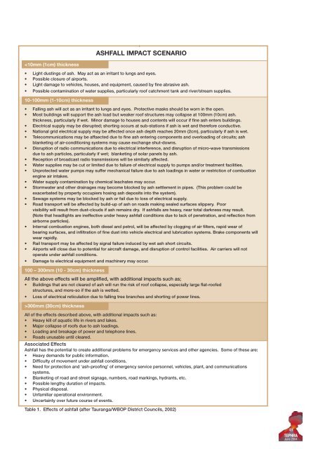
ASHFALL IMPACT SCENARIO 300mm (30cm) thickness All <strong>of</strong> the effects described above, with additional impacts such as: • Heavy kill <strong>of</strong> aquatic life in rivers <strong>and</strong> lakes. • Major collapse <strong>of</strong> ro<strong>of</strong>s due to ash loadings. • Loading <strong>and</strong> breakage <strong>of</strong> power <strong>and</strong> telephone lines. • Roads unusable until cleared. Associated Effects Ashfall has the potential to create additional problems for emergency services <strong>and</strong> other agencies. Some <strong>of</strong> these are: • Heavy dem<strong>and</strong>s for public information. • Difficulty <strong>of</strong> movement under ashfall conditions. • Need for protection <strong>and</strong> ‘ash-pro<strong>of</strong>ing’ <strong>of</strong> emergency service personnel, vehicles, plant, <strong>and</strong> communications systems. • Blanketing <strong>of</strong> road <strong>and</strong> street signage, numbers, road markings, hydrants, etc. • Possible lengthy duration <strong>of</strong> impacts. • Physical disposal. • Unfamiliar operational environment. • Uncertainty over future course <strong>of</strong> events. Table 1. Effects <strong>of</strong> ashfall (after Tauranga/WBOP District Councils, 2002) 49 TEPHRA June 2004
Location Population If Only 60% Evacuate Rotorua District 64,473 ~ 39,000 Kawerau District 6,975 ~ 4,000 Te Teko 630 ~ 400 Te Puke 6,774 ~ 4,000 Murupara 1,959 ~ 1,200 Whakatane District 32,814 ~ 20,000 Tauranga District 90,906 ~ 55,000 Total 204,531 ~125,000 Table 3. Populations <strong>and</strong> possible numbers <strong>of</strong> evacuees in the Bay <strong>of</strong> Plenty region (Census, 2001) well before any evacuation is necessary. Plans for hospitals, schools <strong>and</strong> nursing homes should already have been implemented by each authority, but individual facilities <strong>and</strong> institutions also need to have an evacuation plan. To achieve this, communication links must be established early in the pre-eruption stage. Locations <strong>of</strong> evacuation shelters should be confirmed <strong>and</strong> made accessible <strong>and</strong> known to agencies <strong>and</strong> the public. Vehicle protection, ash clearance, bulk ash disposal, contractor resources <strong>and</strong> arrangements, <strong>and</strong> availability <strong>of</strong> fuel are also important. Lists <strong>of</strong> special equipment <strong>and</strong> supplies should be compiled, including tow trucks, <strong>and</strong> taxi/private bus companies. Plans for potential receiving cities need to be updated; the availability <strong>of</strong> fuel <strong>and</strong> suitable accommodation will need to be monitored prior to an event. EVACUATION ROUTE INFORMATION: The evacuation movement can be either preeruption or during-eruption. The primary method <strong>of</strong> evacuation movement in this area has to be by road, although there is a rail link to Kawerau. Before the eruption, road conditions are unaffected by ash, but apprehension may affect driving skills. Evacuation movement during periods <strong>of</strong> ashfall, is drastically changed by road conditions, <strong>and</strong> therefore, the subsequent action taken by drivers. Under this scenario, most recommended <strong>and</strong> compulsory evacuations take place before any substantial ashfalls in the area. Viable destinations for evacuees from Rotorua include Hamilton, Auckl<strong>and</strong> <strong>and</strong> possibly Tauranga <strong>and</strong> Taupo. However, evacuation to Tauranga <strong>and</strong> Taupo, or to any other city within the Bay <strong>of</strong> Plenty region, is better only as an interim measure. These centres could need to be <strong>evacuate</strong>d themselves if the eruption escalated or wind direction changed. If the route to Taupo is taken, the recommendation given to evacuees will be to travel south along SH 30 through to SH 1, as SH 5 passes close to the Primary Evacuation Zone <strong>and</strong> may be closed prior to the eruption. If the route to Hamilton is taken, the recommendation given to evacuees will be to travel via SH 5 to SH 1 (Fig 4). Clear advice needs to be given to the public, recommending evacuation routes <strong>and</strong> destinations (or destinations to avoid), well in advance <strong>of</strong> an evacuation warning. If the population leaves Kawerau via Kawerau Road to SH 30, the choice lies in either going to the west or east (along SH 30). The best option is to take SH 30 to the east (Fig 5); they could then travel to Te Teko, turn south <strong>and</strong> follow the south route <strong>and</strong> travel on to Taupo via Murupara; or could turn north from Te Teko, or to Matata, on the coast, <strong>and</strong> then northwest to Tauranga. Following this route would be slow, <strong>and</strong> would involve travelling in ashfall-prone areas, once the eruption has commenced. Going to the west will compound the problems in the Rotorua area. A second option is to leave Kawerau by the southern forestry road to Ngamotu Road, although this comes in close proximity to Tarawera volcano, just outside <strong>of</strong> the Primary risk zone. This option is only possible pre-eruption, <strong>and</strong> is likely to be closed as soon as the eruption begins. The options from here are east to Pokairoa Road, following it south to Kopuriki Road until Murupara, then turn west earlier to Rainbow Mountain <strong>and</strong> south to Taupo. EVACUATION BY ROAD This is likely to be the most common transportation method used in evacuations for the Rotorua-Kawerau districts. Most people will be advised to <strong>evacuate</strong> by car, except for a few minority groups who will neither be able to drive, nor be able to travel with friends <strong>and</strong> family. These include special population groups such as hospital patients, residential District Cars Rental cars Taxis Trucks Buses & coaches Trailers Motorcycles Mopeds Tractors Exempt vehicles Misc. Total Auckl<strong>and</strong> 625,590 11,329 3,497 94,595 3,088 71,746 9,187 828 2,530 1,325 3,972 827,687 Hamilton 145,457 481 267 33,112 1,135 38,091 3,200 828 2,486 578 1,190 226,825 Tauranga 92,357 321 129 20,395 506 22,715 2,340 610 1,184 546 1,159 142,262 Rotorua 32,311 69 99 8,147 260 8,284 653 117 459 332 333 51,064 Table 4. Vehicle numbers (registered) in the Bay <strong>of</strong> Plenty/Waikato/Auckl<strong>and</strong> regions (From L<strong>and</strong> Transport Safety Authority, 2000) 50 TEPHRA June 2004