evacuate! - Ministry of Civil Defence and Emergency Management
evacuate! - Ministry of Civil Defence and Emergency Management
evacuate! - Ministry of Civil Defence and Emergency Management

Create successful ePaper yourself
Turn your PDF publications into a flip-book with our unique Google optimized e-Paper software.
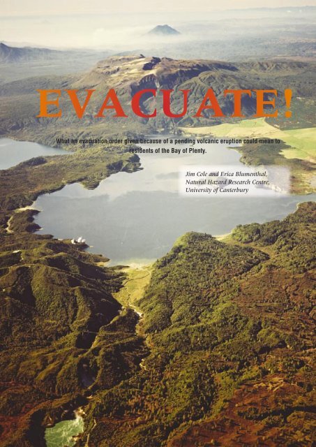
EVACUATE!<br />
What an evacuation order given because <strong>of</strong> a pending volcanic eruption could mean to<br />
residents <strong>of</strong> the Bay <strong>of</strong> Plenty.<br />
Jim Cole <strong>and</strong> Erica Blumenthal,<br />
Natural Hazard Research Centre,<br />
University <strong>of</strong> Canterbury<br />
46<br />
TEPHRA<br />
June 2004
In about 1315AD Tarawera volcano erupted with enormous<br />
force, depositing rhyolitic ash over much <strong>of</strong> the northern<br />
part <strong>of</strong> the North Isl<strong>and</strong>. This was the Kaharoa eruption.<br />
Columns <strong>of</strong> ash may have continued for days or weeks, <strong>and</strong><br />
these were followed by slow extrusion <strong>of</strong> lava domes, with<br />
intermittent ash eruptions, which may have continued for<br />
four years (Nairn et al., 2001). If such an event occurred<br />
today it would cause major disruption to the surrounding<br />
area, as indicated in Table 1. Evacuation <strong>of</strong> some areas will<br />
be inevitable.<br />
The distribution <strong>of</strong> ash will largely depend on<br />
the wind direction at the time <strong>of</strong> the eruption, <strong>and</strong> in an<br />
eruption <strong>of</strong> this magnitude wind direction will change<br />
several times. In the 1315 Kaharoa eruption, ash first<br />
travelled southeastwards, <strong>and</strong> then northwestwards,<br />
covering an area from Northl<strong>and</strong> to Mahia Peninsula<br />
with a layer <strong>of</strong> ash, with the greatest thickness occurring<br />
between Tauranga <strong>and</strong> Murupara (Fig 1). The dominant<br />
high level wind direction is from the west, therefore<br />
areas to the east <strong>of</strong> the volcano are more likely to be<br />
covered with ash, even small amounts <strong>of</strong> which will<br />
cause severe disruption to all forms <strong>of</strong> transportation<br />
(Table 2).<br />
EVACUATION ZONES<br />
The next eruption <strong>of</strong> this type in the Bay <strong>of</strong><br />
Plenty will most probably be from Tarawera or from<br />
Haroharo volcano to the north. When this happens,<br />
Thickness<br />
<strong>of</strong> ash<br />
0-2mm<br />
2-20mm<br />
Effects on roads<br />
Road markings obscured, traction reduced (wet <strong>and</strong><br />
dry ash), visibility reduced as dry ash is remobilised<br />
by traffic <strong>and</strong> wind. Steep hills difficult for 2WD<br />
vehicles to climb.<br />
Moderate hills become difficult for 2WD vehicles<br />
to climb, steep hills impossible. Drifts cause larger<br />
humps in road. Once dampened <strong>and</strong> compacted it<br />
becomes firmer, easier to drive on.<br />
Fig 1. Proximal distribution <strong>of</strong> Kaharoa ashfall deposits; isopach<br />
values in cms (from Johnston et al. 2002)<br />
the highest risk is within a 10km zone around the vent<br />
area, <strong>and</strong> this becomes a Primary Evacuation Zone (Fig<br />
2), including the Rotorua Lakes district (bordering Lakes<br />
Rotokakahi, Tikitapu, Okareka, Tarawera <strong>and</strong> Okataina).<br />
Residents <strong>of</strong> this area would have to be <strong>evacuate</strong>d prior<br />
to commencement <strong>of</strong> the eruption.<br />
Residents on the north shore <strong>of</strong> Lake Tarawera<br />
(along Spencer Road) would be the most vulnerable<br />
to any eruption from Tarawera (Fig 3). This area is<br />
likely to be completely devastated in a Kaharoa-type<br />
eruption from Tarawera or Haroharo, particularly from<br />
ballistic ejecta <strong>and</strong> thick near-vent ashfalls. Therefore,<br />
it is imperative that this area <strong>evacuate</strong>s pre-eruption.<br />
An added problem is the single evacuation route into<br />
<strong>and</strong> out <strong>of</strong> the area. Spencer Road ends at the edge <strong>of</strong><br />
20-100mm<br />
100-<br />
300mm<br />
Slight inclines may be impassable to 2WD vehicles,<br />
4WD vehicles need differential or hub locks to climb<br />
moderate hills. Larger drifts (eg 300mm) may hinder<br />
or stop 2WD vehicles on flat roads.<br />
Uneven surfaces in the ash stop any 2WD vehicles,<br />
compacted damp ash on flat surfaces is still able to<br />
be driven on. 4WD utility type vehicles (not cars) may<br />
be able to slowly progress on the flat. Drifts may need<br />
to be cleared. Moderate inclines difficult, but may be<br />
possible for experienced 4WD drivers. Steep inclines<br />
generally impassable. Ruts easily formed on hills.<br />
>300mm<br />
Compacted ash may be driven on by 4WD vehicles,<br />
s<strong>of</strong>ter patches may easily bog vehicles. Gradual<br />
inclines possible on compacted ash, but after a few<br />
vehicles, ruts in the ash will form, hindering uphill<br />
progress for further vehicles.<br />
Table 2. Ashfall effects on road transportation (from Barnard, 2003)<br />
Fig 2. Evacuation Zones: Zone 1 = 10km radius (primary) zone;<br />
Zone 2 = 40km radius (secondary) zone; Zone 3 = 100km radius<br />
(potentially 'unsafe') zone.<br />
A view looking northeast along the vents <strong>of</strong> the 1886 AD eruption, from Frying Pan Lake in the foreground<br />
to Mt. Tarawera <strong>and</strong> in the background, the cone <strong>of</strong> Mt Edgecumbe. Photo: GNS Lloyd Homer.<br />
47<br />
TEPHRA<br />
June 2004
Fig 3. Lake Tarawera area evacuation route. Spencer Road west to<br />
Tarawera Road to Rotorua.<br />
Fig 5. Kawerau Evacuation Routes. Two possible evacuation routes:<br />
NE via SH30; or south via the main road or the forestry road.<br />
Lake Tarawera <strong>and</strong> is a long narrow road that extends<br />
for ~17 km, from Tarawera Road to Rotorua, making<br />
large-scale evacuation on this road hazardous. There is<br />
also the likelihood <strong>of</strong> l<strong>and</strong>slips occurring on the road,<br />
associated with pre-eruption seismicity, severing the link<br />
to Rotorua. The construction <strong>of</strong> a loop road extending<br />
northwest from Spencer Road to Millar Road, Lake<br />
Okareka, should be considered. This would be <strong>of</strong> benefit<br />
to the local residents at any time, but particularly so<br />
if an eruption is imminent. The use <strong>of</strong> a loop road as<br />
a mitigation measure was implemented by <strong>of</strong>ficials at<br />
Mammoth Mountain (Long Valley, California, USA)<br />
during an eruption scare (Mader & Blair, 1987).<br />
The next level <strong>of</strong> risk will be inside a zone <strong>of</strong><br />
40 kms radius from the erupting volcano (Fig.2). This<br />
is the Secondary Evacuation Zone <strong>and</strong> would include<br />
the urban areas <strong>of</strong> Rotorua, Kawerau <strong>and</strong> Murupara.<br />
Effects on these towns will depend very much on the<br />
wind direction, but such variability puts all in potential<br />
danger. The larger population means that any decision<br />
to <strong>evacuate</strong> becomes a major operation <strong>and</strong> requires<br />
careful planning.<br />
Fig 4. Rotorua Evacuation Routes. Rotorua has two options: south by<br />
SH 30 or SH 5 to Taupo; or west by SH 5 to Hamilton.<br />
URBAN AREAS<br />
Rotorua is situated 25 km west-northwest <strong>of</strong><br />
Tarawera volcano (Fig 4). The population <strong>of</strong> Rotorua<br />
district is 64,473 (Census 2001), <strong>and</strong> a compulsory<br />
evacuation notice may be given if the eruption is large<br />
enough or wind direction is from the east. Because <strong>of</strong><br />
the larger population however, it would be advisable<br />
that voluntary evacuation is encouraged earlier, to<br />
decrease the number <strong>of</strong> potential evacuees where the<br />
compulsory order is given. The importance <strong>of</strong> the timing<br />
<strong>of</strong> any evacuation order is critical: too soon, <strong>and</strong> people<br />
will start to return, believing the emergency is over; too<br />
late, <strong>and</strong> many evacuees will try to <strong>evacuate</strong> at once,<br />
causing panic.<br />
Kawerau is situated 20 km northeast <strong>of</strong> Tarawera<br />
volcano (Fig 5), with a population <strong>of</strong> 6,975 (Census<br />
2001). Kawerau has three main road exits from its<br />
township. It must be remembered that Rotorua <strong>and</strong><br />
Te Teko could also have been ordered to <strong>evacuate</strong> at<br />
this time. This puts pressure on some roads <strong>and</strong> other<br />
evacuation routes.<br />
Population statistics <strong>of</strong> the potential evacuation<br />
areas are presented in Table 3. The percentage <strong>of</strong><br />
residents who actually <strong>evacuate</strong> is hard to estimate.<br />
A figure <strong>of</strong> 50-70% <strong>of</strong> the population, is presented by<br />
Auckl<strong>and</strong> Regional Council (1996) as the “anticipated<br />
maximum credible [evacuee] number” in the event<br />
<strong>of</strong> an eruption from the Auckl<strong>and</strong> volcanic field. This<br />
percentage is supported by Dow <strong>and</strong> Cutter (2002)<br />
who found there was an evacuation rate <strong>of</strong> 65% during<br />
Hurricane Floyd in the USA. Therefore, in Table 3, an<br />
estimated 60% <strong>of</strong> the affected Bay <strong>of</strong> Plenty region<br />
population is taken as a potential figure for numbers <strong>of</strong><br />
evacuees.<br />
Plans for evacuation movement, ie. major<br />
evacuation routes <strong>and</strong> destinations, must be in place<br />
48<br />
TEPHRA<br />
June 2004
ASHFALL IMPACT SCENARIO<br />
300mm (30cm) thickness<br />
All <strong>of</strong> the effects described above, with additional impacts such as:<br />
• Heavy kill <strong>of</strong> aquatic life in rivers <strong>and</strong> lakes.<br />
• Major collapse <strong>of</strong> ro<strong>of</strong>s due to ash loadings.<br />
• Loading <strong>and</strong> breakage <strong>of</strong> power <strong>and</strong> telephone lines.<br />
• Roads unusable until cleared.<br />
Associated Effects<br />
Ashfall has the potential to create additional problems for emergency services <strong>and</strong> other agencies. Some <strong>of</strong> these are:<br />
• Heavy dem<strong>and</strong>s for public information.<br />
• Difficulty <strong>of</strong> movement under ashfall conditions.<br />
• Need for protection <strong>and</strong> ‘ash-pro<strong>of</strong>ing’ <strong>of</strong> emergency service personnel, vehicles, plant, <strong>and</strong> communications<br />
systems.<br />
• Blanketing <strong>of</strong> road <strong>and</strong> street signage, numbers, road markings, hydrants, etc.<br />
• Possible lengthy duration <strong>of</strong> impacts.<br />
• Physical disposal.<br />
• Unfamiliar operational environment.<br />
• Uncertainty over future course <strong>of</strong> events.<br />
Table 1. Effects <strong>of</strong> ashfall (after Tauranga/WBOP District Councils, 2002)<br />
49<br />
TEPHRA<br />
June 2004
Location Population If Only 60% Evacuate<br />
Rotorua District 64,473 ~ 39,000<br />
Kawerau District 6,975 ~ 4,000<br />
Te Teko 630 ~ 400<br />
Te Puke 6,774 ~ 4,000<br />
Murupara 1,959 ~ 1,200<br />
Whakatane District 32,814 ~ 20,000<br />
Tauranga District 90,906 ~ 55,000<br />
Total 204,531 ~125,000<br />
Table 3. Populations <strong>and</strong> possible numbers <strong>of</strong> evacuees in the Bay<br />
<strong>of</strong> Plenty region (Census, 2001)<br />
well before any evacuation is necessary. Plans for<br />
hospitals, schools <strong>and</strong> nursing homes should already<br />
have been implemented by each authority, but<br />
individual facilities <strong>and</strong> institutions also need to have<br />
an evacuation plan. To achieve this, communication<br />
links must be established early in the pre-eruption stage.<br />
Locations <strong>of</strong> evacuation shelters should be confirmed<br />
<strong>and</strong> made accessible <strong>and</strong> known to agencies <strong>and</strong> the<br />
public. Vehicle protection, ash clearance, bulk ash<br />
disposal, contractor resources <strong>and</strong> arrangements, <strong>and</strong><br />
availability <strong>of</strong> fuel are also important. Lists <strong>of</strong> special<br />
equipment <strong>and</strong> supplies should be compiled, including<br />
tow trucks, <strong>and</strong> taxi/private bus companies. Plans<br />
for potential receiving cities need to be updated; the<br />
availability <strong>of</strong> fuel <strong>and</strong> suitable accommodation will<br />
need to be monitored prior to an event.<br />
EVACUATION ROUTE INFORMATION:<br />
The evacuation movement can be either preeruption<br />
or during-eruption. The primary method <strong>of</strong><br />
evacuation movement in this area has to be by road,<br />
although there is a rail link to Kawerau. Before the<br />
eruption, road conditions are unaffected by ash, but<br />
apprehension may affect driving skills. Evacuation<br />
movement during periods <strong>of</strong> ashfall, is drastically<br />
changed by road conditions, <strong>and</strong> therefore, the<br />
subsequent action taken by drivers. Under this scenario,<br />
most recommended <strong>and</strong> compulsory evacuations take<br />
place before any substantial ashfalls in the area.<br />
Viable destinations for evacuees from Rotorua<br />
include Hamilton, Auckl<strong>and</strong> <strong>and</strong> possibly Tauranga <strong>and</strong><br />
Taupo. However, evacuation to Tauranga <strong>and</strong> Taupo,<br />
or to any other city within the Bay <strong>of</strong> Plenty region,<br />
is better only as an interim measure. These centres<br />
could need to be <strong>evacuate</strong>d themselves if the eruption<br />
escalated or wind direction changed. If the route to<br />
Taupo is taken, the recommendation given to evacuees<br />
will be to travel south along SH 30 through to SH 1,<br />
as SH 5 passes close to the Primary Evacuation Zone<br />
<strong>and</strong> may be closed prior to the eruption. If the route<br />
to Hamilton is taken, the recommendation given to<br />
evacuees will be to travel via SH 5 to SH 1 (Fig 4).<br />
Clear advice needs to be given to the public,<br />
recommending evacuation routes <strong>and</strong> destinations (or<br />
destinations to avoid), well in advance <strong>of</strong> an evacuation<br />
warning.<br />
If the population leaves Kawerau via Kawerau<br />
Road to SH 30, the choice lies in either going to the west<br />
or east (along SH 30). The best option is to take SH 30 to<br />
the east (Fig 5); they could then travel to Te Teko, turn<br />
south <strong>and</strong> follow the south route <strong>and</strong> travel on to Taupo<br />
via Murupara; or could turn north from Te Teko, or to<br />
Matata, on the coast, <strong>and</strong> then northwest to Tauranga.<br />
Following this route would be slow, <strong>and</strong> would involve<br />
travelling in ashfall-prone areas, once the eruption<br />
has commenced. Going to the west will compound the<br />
problems in the Rotorua area.<br />
A second option is to leave Kawerau by the<br />
southern forestry road to Ngamotu Road, although<br />
this comes in close proximity to Tarawera volcano, just<br />
outside <strong>of</strong> the Primary risk zone. This option is only<br />
possible pre-eruption, <strong>and</strong> is likely to be closed as soon<br />
as the eruption begins. The options from here are east to<br />
Pokairoa Road, following it south to Kopuriki Road until<br />
Murupara, then turn west earlier to Rainbow Mountain<br />
<strong>and</strong> south to Taupo.<br />
EVACUATION BY ROAD<br />
This is likely to be the most common<br />
transportation method used in evacuations for the<br />
Rotorua-Kawerau districts. Most people will be advised<br />
to <strong>evacuate</strong> by car, except for a few minority groups<br />
who will neither be able to drive, nor be able to<br />
travel with friends <strong>and</strong> family. These include special<br />
population groups such as hospital patients, residential<br />
District<br />
Cars<br />
Rental<br />
cars<br />
Taxis<br />
Trucks<br />
Buses &<br />
coaches<br />
Trailers<br />
Motorcycles<br />
Mopeds<br />
Tractors<br />
Exempt<br />
vehicles<br />
Misc.<br />
Total<br />
Auckl<strong>and</strong> 625,590 11,329 3,497 94,595 3,088 71,746 9,187 828 2,530 1,325 3,972 827,687<br />
Hamilton 145,457 481 267 33,112 1,135 38,091 3,200 828 2,486 578 1,190 226,825<br />
Tauranga 92,357 321 129 20,395 506 22,715 2,340 610 1,184 546 1,159 142,262<br />
Rotorua 32,311 69 99 8,147 260 8,284 653 117 459 332 333 51,064<br />
Table 4. Vehicle numbers (registered) in the Bay <strong>of</strong> Plenty/Waikato/Auckl<strong>and</strong> regions (From L<strong>and</strong> Transport Safety Authority, 2000)<br />
50<br />
TEPHRA<br />
June 2004
schools (if there is need for a<br />
rapid evacuation), nursing homes<br />
<strong>and</strong> retirement villages. In these<br />
cases, it will be recommended that<br />
people travel on buses, but each<br />
organisation will need to meet<br />
their own evacuation procedures.<br />
Rotorua district has 32,311<br />
registered cars in the district<br />
(Table 4); 32,479 including rental<br />
cars <strong>and</strong> taxis, together with 260<br />
buses <strong>and</strong> coaches. Assuming a<br />
population <strong>of</strong> 64,473, the number<br />
<strong>of</strong> cars would appear to be<br />
adequate, assuming two people per<br />
car. For those without a household<br />
car, or without the opportunity<br />
to travel with friends or relations,<br />
they will need to rely on buses <strong>and</strong><br />
coaches. Measures must be taken<br />
to ensure these are organised in<br />
advance, with meeting points <strong>and</strong><br />
drivers prearranged.<br />
Census 2001 states that<br />
90.9% <strong>of</strong> households in the Bay<br />
<strong>of</strong> Plenty region have access to<br />
a motor vehicle. As there are<br />
86,793 households in the Bay <strong>of</strong><br />
Plenty, there are therefore 7,899 households without<br />
access. With an average household population (Bay <strong>of</strong><br />
Plenty region) <strong>of</strong> 2.6 persons, this will result in about<br />
20,535 people in the region without access to a motor<br />
vehicle. From these figures it appears that Rotorua has<br />
~6,420 people without access to a motor vehicle, while<br />
Kawerau District has ~939 people without access to a<br />
motor vehicle. The assumption is made that most <strong>of</strong> the<br />
7,359 people, from these key areas, will need public<br />
transport (Table 5).<br />
SECURITY OF EVACUATED AREA<br />
The security <strong>of</strong> the <strong>evacuate</strong>d area is intimately<br />
linked with authority <strong>and</strong> responsibility. It is extremely<br />
important that measures are taken to secure <strong>evacuate</strong>d<br />
areas, <strong>and</strong> that evacuees are aware that this will<br />
be done. The security <strong>of</strong> the <strong>evacuate</strong>d area is also<br />
important to continue sustainability <strong>of</strong> lifelines in the<br />
area, to encourage clean-up <strong>and</strong> return <strong>of</strong> evacuees after<br />
Kawerau, with a population <strong>of</strong> almost 7,000, lies 20km northeast <strong>of</strong><br />
Tarawera Volcano (out <strong>of</strong> picture to the right). In the background Lake<br />
Pupuwharu <strong>and</strong> Mt Edgecumbe. Photo: GNS Lloyd Homer.<br />
the event. During many past evacuations, (eg. Rabaul<br />
1994) looting <strong>and</strong> other negative socially destructive<br />
actions have occurred, by individuals <strong>and</strong> groups <strong>and</strong><br />
this must be avoided at all costs.<br />
RECOVERY<br />
Initial destinations for evacuees are likely to be<br />
Auckl<strong>and</strong>, Hamilton, Tauranga, <strong>and</strong> Taupo. However,<br />
many smaller destinations will receive evacuees, with<br />
many people wishing to choose their own destination<br />
because <strong>of</strong> relatives or friends. It is also possible that<br />
some <strong>of</strong> the cities (eg. Tauranga <strong>and</strong> Taupo) could<br />
need to be <strong>evacuate</strong>d themselves <strong>and</strong> are therefore not<br />
recommended as ideal final destination points.<br />
Evacuees should be advised to <strong>evacuate</strong> further<br />
than the ~100 km ‘unsafe’ radius from Tarawera<br />
volcano (Fig.2). After initial destinations have been<br />
Total number <strong>of</strong><br />
households<br />
Access to a motor<br />
vehicle (%)<br />
Average numbers in<br />
household<br />
Calculated no.<br />
people without<br />
motor vehicles<br />
If 60% people<br />
<strong>evacuate</strong><br />
Rotorua 22,254 89.7 2.8 6,420 3,852<br />
Kawerau 2313 86 2.9 939 563<br />
Total 7,359<br />
Table 5. Residents without access to a motor vehicle from key centres in the Bay <strong>of</strong> Plenty region (Census, 2001)<br />
51<br />
TEPHRA<br />
June 2004
eached, it will be possible to transfer evacuees to other<br />
points around the country, <strong>and</strong> to family <strong>and</strong> friends<br />
outside <strong>evacuate</strong>d zones. This subsequent transfer is<br />
recommended to decrease the effect on public resources,<br />
<strong>and</strong> for the preservation <strong>of</strong> mental health <strong>and</strong> emotional<br />
support, as it is essential to counteract subsequent<br />
negative impacts on the evacuees. The National Evacuee<br />
Registration system will be required, so that enquiries<br />
from friends <strong>and</strong> relations can be dealt with effectively.<br />
As the largest city in New Zeal<strong>and</strong>, Auckl<strong>and</strong> is<br />
expected to have the largest accommodation resource<br />
<strong>of</strong> the cities considered, with numerous hotels, motels,<br />
<strong>and</strong> schools. The short-term accommodation sources<br />
are friends <strong>and</strong> family, motels, camping grounds, <strong>and</strong><br />
dormitories. Most evacuees are expected <strong>and</strong> are<br />
recommended to travel to these sources once leaving<br />
the evacuation shelters. Auckl<strong>and</strong> is also thought to be a<br />
good medium <strong>and</strong> longer-term shelter (<strong>and</strong> relocation)<br />
destination, because <strong>of</strong> the accommodation resources<br />
<strong>and</strong> potential employment opportunities available.<br />
For short-term shelter purposes, Hamilton can<br />
provide up to 900 beds, which would include both<br />
motel <strong>and</strong> marae accommodation. Longer-term shelter<br />
resources include various hotels, motels <strong>and</strong> camping<br />
grounds. Hamilton would be a good medium-term<br />
sheltering destination, however less so for short-term<br />
shelter.<br />
Taupo may be an interim destination, <strong>and</strong> as<br />
such will be able to provide a small amount <strong>of</strong> support<br />
shelter. Taupo <strong>and</strong> the surrounding district have welfare<br />
centres, including the Great Lake Centre <strong>and</strong> the<br />
Events Centre (which can accommodate ~100 each),<br />
plus primary schools (22) <strong>and</strong> motels, which may be<br />
available for short-term shelter.<br />
The Tauranga-Western Bay <strong>Emergency</strong><br />
<strong>Management</strong> <strong>Civil</strong> <strong>Defence</strong> Plan (2002) states that<br />
the preferred option for short-term emergency<br />
accommodation for smaller numbers <strong>of</strong> evacuees is the<br />
use <strong>of</strong> the combined district/region’s hotels <strong>and</strong> motels.<br />
It states that should large numbers be involved, other<br />
facilities will be used. It also states that registers <strong>of</strong><br />
locations <strong>and</strong> premises suitable for short-term shelter for<br />
evacuees are held by the <strong>Emergency</strong> Operations Centre.<br />
Arrangements for long-term accommodation <strong>and</strong>/or<br />
resettlement <strong>of</strong> displaced persons are to be addressed by<br />
the appropriate Disaster Recovery Manager.<br />
Major shelter facilities (able to provide catering,<br />
showers, car-parking, accommodation) include Tauranga<br />
Racecourse, Greerton; Papamoa Sports Club, Papamoa;<br />
Bay Park Stadium, Te Mauna; QEII Memorial Hall,<br />
Tauranga; Blake Park Stadium, Mt Maunganui; <strong>and</strong><br />
Community Centre, Waihi Beach. Medium-term<br />
facilities (greater than 72 hours) include motels,<br />
campground cabins, caravan parks <strong>and</strong> sites, with total<br />
capacity estimated to be around 8,000 people. However,<br />
as previously noted, Tauranga is not the best medium or<br />
long-term sheltering location.<br />
CONCLUSIONS<br />
Local authorities are certainly aware <strong>of</strong> the<br />
possible need for evacuation in the event <strong>of</strong> an eruption;<br />
the National Contingency Plan for Volcanic Eruptions<br />
(within the National <strong>Civil</strong> <strong>Defence</strong> Plan) highlights the<br />
need for awareness <strong>of</strong> volcanic hazard management <strong>and</strong><br />
preparedness. However detailed evacuation plans for<br />
all areas must be established well before any eruption<br />
occurs. Once there are signs <strong>of</strong> an impending eruption,<br />
it is too late to have a well managed, orderly evacuation.<br />
How many local people in the potential evacuation areas<br />
are aware <strong>of</strong> the possibility <strong>of</strong> evacuation is an open<br />
question, but one that should be addressed as detailed<br />
plans are drawn up.<br />
REFERENCES<br />
Auckl<strong>and</strong> Regional Council. 1996. Strategy<br />
for evacuees from outside Auckl<strong>and</strong> region. Being the<br />
Auckl<strong>and</strong> Regional Council <strong>Civil</strong> <strong>Defence</strong> Plan for the<br />
northerly evacuation <strong>of</strong> Ruapehu District by resources<br />
wholly from the Auckl<strong>and</strong> region. Auckl<strong>and</strong> Regional<br />
Council. 25p.<br />
Barnard, S. 2003. Potential effects <strong>of</strong> any future<br />
1886-type eruption from Tarawera volcano on the Bay<br />
<strong>of</strong> Plenty region. Unpublished MSc thesis, University <strong>of</strong><br />
Canterbury, Christchurch.<br />
Census, 2001. [www.stats.govt.nz].<br />
Dow, K. <strong>and</strong> Cutter, S.I. 2002. Emerging<br />
Hurricane Evacuation Issues: Hurricane Floyd <strong>and</strong> South<br />
Carolina. Natural Hazards Review 3: 12-18.<br />
L<strong>and</strong> Transport Authority. 2000. Motor Vehicle<br />
Registration Statistics.<br />
Mader, C.G. <strong>and</strong> Blair, M.L. 1987. Living with<br />
a volcanic threat: Response to volcanic hazards, Long<br />
Valley, California. William Sprangle, Portola Valley,<br />
California. 105p.<br />
Nairn, I.A., Self, S., Cole, J.W., Leonard, G.S. <strong>and</strong><br />
Scutter, C. 2001. Distribution, stratigraphy, <strong>and</strong> history<br />
<strong>of</strong> proximal deposits from the c.AD 1305 Kaharoa<br />
eruptive episode at Tarawera Volcano, New Zeal<strong>and</strong>,<br />
New Zeal<strong>and</strong> Journal <strong>of</strong> Geology <strong>and</strong> Geophysics 44:<br />
467-484.<br />
Tauranga-WBOP <strong>Emergency</strong> <strong>Management</strong>.<br />
2002. <strong>Civil</strong> <strong>Defence</strong> Plan 2002. <strong>Emergency</strong> <strong>Management</strong><br />
Office, Western Bay <strong>of</strong> Plenty District Council, Tauranga.<br />
Johnston, D., Nairn, I., Martin, R. 2002.<br />
Proximal impacts <strong>of</strong> the ~1305AD Kaharoa eruption on<br />
modern day New Zeal<strong>and</strong>. Institute <strong>of</strong> Geological <strong>and</strong><br />
Nuclear Sciences Science Report 2002/18. 28p.<br />
52<br />
TEPHRA<br />
June 2004