evacuate! - Ministry of Civil Defence and Emergency Management
evacuate! - Ministry of Civil Defence and Emergency Management
evacuate! - Ministry of Civil Defence and Emergency Management

You also want an ePaper? Increase the reach of your titles
YUMPU automatically turns print PDFs into web optimized ePapers that Google loves.
In about 1315AD Tarawera volcano erupted with enormous<br />
force, depositing rhyolitic ash over much <strong>of</strong> the northern<br />
part <strong>of</strong> the North Isl<strong>and</strong>. This was the Kaharoa eruption.<br />
Columns <strong>of</strong> ash may have continued for days or weeks, <strong>and</strong><br />
these were followed by slow extrusion <strong>of</strong> lava domes, with<br />
intermittent ash eruptions, which may have continued for<br />
four years (Nairn et al., 2001). If such an event occurred<br />
today it would cause major disruption to the surrounding<br />
area, as indicated in Table 1. Evacuation <strong>of</strong> some areas will<br />
be inevitable.<br />
The distribution <strong>of</strong> ash will largely depend on<br />
the wind direction at the time <strong>of</strong> the eruption, <strong>and</strong> in an<br />
eruption <strong>of</strong> this magnitude wind direction will change<br />
several times. In the 1315 Kaharoa eruption, ash first<br />
travelled southeastwards, <strong>and</strong> then northwestwards,<br />
covering an area from Northl<strong>and</strong> to Mahia Peninsula<br />
with a layer <strong>of</strong> ash, with the greatest thickness occurring<br />
between Tauranga <strong>and</strong> Murupara (Fig 1). The dominant<br />
high level wind direction is from the west, therefore<br />
areas to the east <strong>of</strong> the volcano are more likely to be<br />
covered with ash, even small amounts <strong>of</strong> which will<br />
cause severe disruption to all forms <strong>of</strong> transportation<br />
(Table 2).<br />
EVACUATION ZONES<br />
The next eruption <strong>of</strong> this type in the Bay <strong>of</strong><br />
Plenty will most probably be from Tarawera or from<br />
Haroharo volcano to the north. When this happens,<br />
Thickness<br />
<strong>of</strong> ash<br />
0-2mm<br />
2-20mm<br />
Effects on roads<br />
Road markings obscured, traction reduced (wet <strong>and</strong><br />
dry ash), visibility reduced as dry ash is remobilised<br />
by traffic <strong>and</strong> wind. Steep hills difficult for 2WD<br />
vehicles to climb.<br />
Moderate hills become difficult for 2WD vehicles<br />
to climb, steep hills impossible. Drifts cause larger<br />
humps in road. Once dampened <strong>and</strong> compacted it<br />
becomes firmer, easier to drive on.<br />
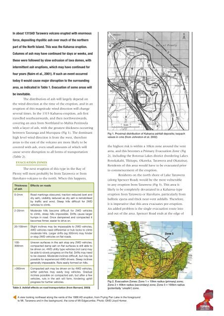
Fig 1. Proximal distribution <strong>of</strong> Kaharoa ashfall deposits; isopach<br />
values in cms (from Johnston et al. 2002)<br />
the highest risk is within a 10km zone around the vent<br />
area, <strong>and</strong> this becomes a Primary Evacuation Zone (Fig<br />
2), including the Rotorua Lakes district (bordering Lakes<br />
Rotokakahi, Tikitapu, Okareka, Tarawera <strong>and</strong> Okataina).<br />
Residents <strong>of</strong> this area would have to be <strong>evacuate</strong>d prior<br />
to commencement <strong>of</strong> the eruption.<br />
Residents on the north shore <strong>of</strong> Lake Tarawera<br />
(along Spencer Road) would be the most vulnerable<br />
to any eruption from Tarawera (Fig 3). This area is<br />
likely to be completely devastated in a Kaharoa-type<br />
eruption from Tarawera or Haroharo, particularly from<br />
ballistic ejecta <strong>and</strong> thick near-vent ashfalls. Therefore,<br />
it is imperative that this area <strong>evacuate</strong>s pre-eruption.<br />
An added problem is the single evacuation route into<br />
<strong>and</strong> out <strong>of</strong> the area. Spencer Road ends at the edge <strong>of</strong><br />
20-100mm<br />
100-<br />
300mm<br />
Slight inclines may be impassable to 2WD vehicles,<br />
4WD vehicles need differential or hub locks to climb<br />
moderate hills. Larger drifts (eg 300mm) may hinder<br />
or stop 2WD vehicles on flat roads.<br />
Uneven surfaces in the ash stop any 2WD vehicles,<br />
compacted damp ash on flat surfaces is still able to<br />
be driven on. 4WD utility type vehicles (not cars) may<br />
be able to slowly progress on the flat. Drifts may need<br />
to be cleared. Moderate inclines difficult, but may be<br />
possible for experienced 4WD drivers. Steep inclines<br />
generally impassable. Ruts easily formed on hills.<br />
>300mm<br />
Compacted ash may be driven on by 4WD vehicles,<br />
s<strong>of</strong>ter patches may easily bog vehicles. Gradual<br />
inclines possible on compacted ash, but after a few<br />
vehicles, ruts in the ash will form, hindering uphill<br />
progress for further vehicles.<br />
Table 2. Ashfall effects on road transportation (from Barnard, 2003)<br />
Fig 2. Evacuation Zones: Zone 1 = 10km radius (primary) zone;<br />
Zone 2 = 40km radius (secondary) zone; Zone 3 = 100km radius<br />
(potentially 'unsafe') zone.<br />
A view looking northeast along the vents <strong>of</strong> the 1886 AD eruption, from Frying Pan Lake in the foreground<br />
to Mt. Tarawera <strong>and</strong> in the background, the cone <strong>of</strong> Mt Edgecumbe. Photo: GNS Lloyd Homer.<br />
47<br />
TEPHRA<br />
June 2004