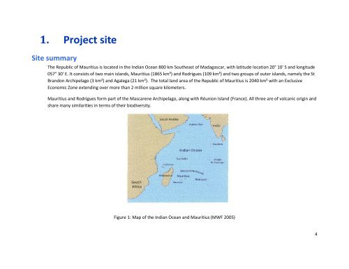
- Page 1 and 2: The Republic of Mauritius Project P
- Page 3: 3. THREAT RANKING ANALYSIS.........
- Page 7 and 8: B. Physical region Key Mauritius is
- Page 9 and 10: C. Infrastructure around site The t
- Page 11 and 12: B. Land Tenure Land in Mauritius is
- Page 13 and 14: The business climate is friendly ye
- Page 15 and 16: III. Main Factors affecting the Sit
- Page 17 and 18: B. Conservation history Conservatio
- Page 19 and 20: Ile aux Aigrettes Area: 26 ha Prese
- Page 21 and 22: N W E S N. Cole 2009 Darwin Initiat
- Page 23 and 24: the reservoir for storing water the
- Page 25 and 26: Ilot Vacoas Area: 1.06 Hectares Pre
- Page 27 and 28: Ile aux Mariannes Area: 4.05 Hectar
- Page 29 and 30: N 0 1 0 0 2 0 0 M e t e r s R o c k
- Page 31 and 32: The Convention for the Protection o
- Page 33 and 34: E. Conservation legislation The mai
- Page 35 and 36: “The President may, by Proclamati
- Page 37 and 38: The “zone” is defined in sectio
- Page 39 and 40: Project team and stakeholders The f
- Page 41 and 42: B) Having 2 hr sessions at schools.
- Page 43 and 44: 2. Developing the Concept Model The
- Page 45 and 46: Figure 10: Initial concept model 45
- Page 47 and 48: The ranking served to: i. Identify
- Page 49 and 50: 4. Formative Research Directed conv
- Page 51 and 52: 16. Have you ever seen any on the i
- Page 53 and 54: _ c 0 Survey results Methods of sam
- Page 55 and 56:
.gi f _ c 0 Q3: How old were you at
- Page 57 and 58:
Q7a: Person on the radio Person on
- Page 59 and 60:
Among 4 lizards named (A= Telfair s
- Page 61 and 62:
Further 57% (n=1119; Q26a) say it i
- Page 63 and 64:
If going for a barbecue on the isle
- Page 65 and 66:
5. Pride Campaign developments Revi
- Page 67 and 68:
Flagship species Figure 10: Flagshi
- Page 69 and 70:
Barrier removal partners The Nation
- Page 71 and 72:
endemic species is hardly known amo
- Page 73 and 74:
and neighbours. Trusted sources Med
- Page 75 and 76:
Other AUDIENCE : School children Wh
- Page 77 and 78:
Figure 13: Result chain of Secondar
- Page 79 and 80:
Figure 15: Result chain of other Au
- Page 81 and 82:
SMART OB5 - By April 2009 the numbe
- Page 83 and 84:
SMART OB16 - By April 2009 out of t
- Page 85 and 86:
Key OT OT1 OT 2 OT 3 OT 4 OT 5 Obje
- Page 87 and 88:
Key Messages Know: Mauritius i
- Page 89 and 90:
The reptiles of Mauritius are our n
- Page 91 and 92:
Activity #2 Channel: Information Ve
- Page 93 and 94:
Activity #3 Key Messages STRATEGIES
- Page 95 and 96:
threats. 95
- Page 97 and 98:
Together we can save our reptiles.
- Page 99 and 100:
Activity #5 Key Messages STRATEGIES
- Page 101 and 102:
3. Gecko tattoos will be offered an
- Page 103 and 104:
Pre-requisites Permission from the
- Page 105 and 106:
Activity #8 Channel: Fact sheet wit
- Page 107 and 108:
Activity #10 Channel: Signage on Is
- Page 109 and 110:
Activity #12 Channel: Gecko week Ve
- Page 111 and 112:
111
- Page 113 and 114:
Budget allocation 113
- Page 115 and 116:
115
- Page 117 and 118:
Through a variety of a range of pro
- Page 119 and 120:
7. Acknowledgements The Mauritian W
- Page 121 and 122:
9. Appendices Appendix 1 The Islets
- Page 123 and 124:
Any islet that has a significant nu
- Page 125 and 126:
outbreak of a serious fire the resp
- Page 127 and 128:
Community Participation It is funda
- Page 129 and 130:
Organizing awareness raising events
- Page 131 and 132:
Organization responsible for manage
- Page 133 and 134:
The round table on Legislation and
- Page 135 and 136:
Appendix 2 Stakeholder’s Matrix R
- Page 137 and 138:
No Participant/ Stakeholder 16 Ecos
- Page 139 and 140:
No Participant/ Stakeholder Sector:
- Page 141 and 142:
Respondent agrees to be interviewed
- Page 143 and 144:
[ ] Radio [ ] Newspaper [ ] Televis
- Page 145 and 146:
(C) What comes to mind when you thi
- Page 147 and 148:
(B) Do you think that some of the i
- Page 149 and 150:
[ ] Strongly Agree [ ] Agree [ ] Ne
- Page 151 and 152:
(B) Seen poster about the the islet
- Page 153 and 154:
Moreover, media preferences to be u
- Page 155 and 156:
Sandra 27 2.4% Danylo 26 2.3% Desir
- Page 157 and 158:
_ c 0 Village name where survey is
- Page 159 and 160:
-- Respondent agrees to be intervie
- Page 161 and 162:
Plaine Magnien 188 16.8% bar_c0. Ba
- Page 163 and 164:
_ c 0 26-30 151 13.5% b 51-60 113 1
- Page 165 and 166:
Fisherman 56 5.0% Retired 46 4.1% S
- Page 167 and 168:
Advanced Level 1 0.1% Form 3 1 0.1%
- Page 169 and 170:
La Voix de la Delivrance 2 0.2% Chi
- Page 171 and 172:
Very trustworthy 431 38.5% bar_c0.g
- Page 173 and 174:
c 0 Q7e: Government environment off
- Page 175 and 176:
Q7g: Religious leaders Religious le
- Page 177 and 178:
Q7i: Teachers Teachers Counts Perce
- Page 179 and 180:
Internet 10 0.9% Local community le
- Page 181 and 182:
In the past month, would you say th
- Page 183 and 184:
Defi jeune 3 0.3% L Hebdo 2 0.2% Ot
- Page 185 and 186:
c 0 MBC radio 332 29.7% bar_c0.gif
- Page 187 and 188:
5 am - 6am 97 8.7% Midnight - 5 am
- Page 189 and 190:
_ c 0 Music local 532 47.5% bar_c0.
- Page 191 and 192:
MBC 2 118 10.5% Movie Channel 62 5.
- Page 193 and 194:
_ c 0 Not applicable 180 16.1% bar_
- Page 195 and 196:
There a need to protect them 10 0.9
- Page 197 and 198:
fishing 116 10.4% barbecuing 91 8.1
- Page 199 and 200:
If you know, can you name 3 plants/
- Page 201 and 202:
Echo Parakeet 4 0.4% Other 214 19.5
- Page 203 and 204:
-- Q20: According to you, are there
- Page 205 and 206:
.gi f 0 100 Yes 926 82.8% bar_c0.gi
- Page 207 and 208:
Yes 403 36.0% bar_c0.gif Totals 111
- Page 209 and 210:
Q21d: How would you best describe t
- Page 211 and 212:
Counts Percents Percents 0 100 C 78
- Page 213 and 214:
Not Applicable 423 37.8% bar_c0.gif
- Page 215 and 216:
-- Q23c: If Yes, Why should they be
- Page 217 and 218:
Do you know that if some of the isl
- Page 219 and 220:
Petit Rat 1 0.1% Other 1 0.1% Total
- Page 221 and 222:
Camping prohibited 8 0.7% Dumping i
- Page 223 and 224:
Q23h: Do you think that there is a
- Page 225 and 226:
0 100 No 870 77.7% bar_c0.gif Yes 2
- Page 227 and 228:
Counts Percents Percents 0 100 Agre
- Page 229 and 230:
0 100 Agree 468 41.8% bar_c0.gif St
- Page 231 and 232:
0 100 Agree 398 35.6% bar_c0.gif Di
- Page 233 and 234:
Not Important 203 18.1% bar_c0.gif
- Page 235 and 236:
that activity Q27a: Report a person
- Page 237 and 238:
-- Q27c: Stop visiting the inland o
- Page 239 and 240:
Your immediate family, including sp
- Page 241 and 242:
-- Q28d: A community leader, such a
- Page 243 and 244:
c 0 method, I would like you to tel
- Page 245 and 246:
0 100 No 953 85.3% bar_c0.gif Yes 1
- Page 247 and 248:
No answer 4 0.4% Totals 1117 100.0%
- Page 249 and 250:
10. References Atkinson, R. and Sev
- Page 251:
Vinson, J. (1976) The distribution