Report on the Physical Nature of the Victorian Fires occurring on 7th ...
Report on the Physical Nature of the Victorian Fires occurring on 7th ...
Report on the Physical Nature of the Victorian Fires occurring on 7th ...

Create successful ePaper yourself
Turn your PDF publications into a flip-book with our unique Google optimized e-Paper software.
EXP.003.001.0031<br />
Tolhurst (2009)<br />
“Describing The Black Saturday <strong>Fires</strong>”<br />
Table 2.<br />
Summary <strong>of</strong> fire behaviour statistics for four <strong>of</strong> <strong>the</strong> main fires burning <strong>on</strong><br />
Black Saturday, 7 February 2009, in Victoria.<br />
Kilmore Murrundindi Churchill Bunyip<br />
Maximum fireline intensity (kW/m) 150,000 150,000 71,000 77,000<br />
Average fireline intensity, N’ly wind (kW/m) 100,000 100,000 45,000 38,700<br />
Average fireline intensity, S’ly wind (kW/m) 64,000 71,000 64,500 25,800<br />
Total heat output (TJ) 53,000 36,000 11,000 10,000<br />
Maximum spread rate in <strong>on</strong>e hour (km/h) 12 12 5.5 6<br />
Average spread rate in <strong>on</strong>e hour N’ly wind (km/h) 8 8 3.5 3<br />
Average spread rate in <strong>on</strong>e hour S’ly wind (km/h) 5 5.5 5 2<br />
Area burnt <strong>on</strong> 7 th Feb. (ha) 114,929 77,400 23,800 21,000<br />
Maximum spotting distance (km) 35 23 24 16<br />
Average spotting distance (km) 10-15 7 8 11<br />
Predictability using Current Models<br />
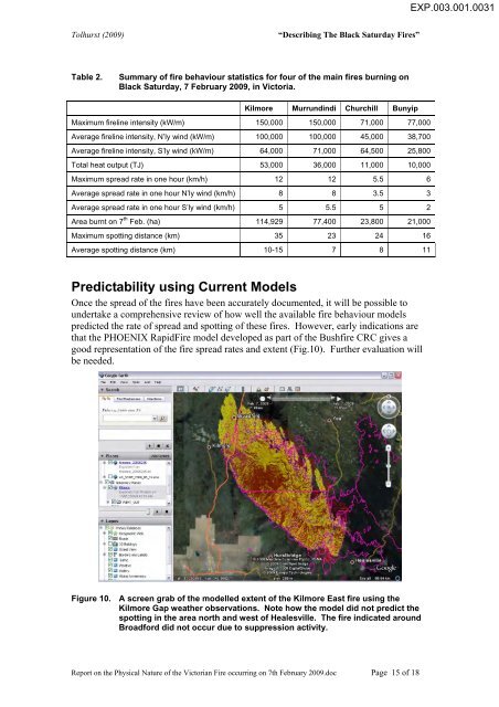
Once <strong>the</strong> spread <strong>of</strong> <strong>the</strong> fires have been accurately documented, it will be possible to<br />
undertake a comprehensive review <strong>of</strong> how well <strong>the</strong> available fire behaviour models<br />
predicted <strong>the</strong> rate <strong>of</strong> spread and spotting <strong>of</strong> <strong>the</strong>se fires. However, early indicati<strong>on</strong>s are<br />
that <strong>the</strong> PHOENIX RapidFire model developed as part <strong>of</strong> <strong>the</strong> Bushfire CRC gives a<br />
good representati<strong>on</strong> <strong>of</strong> <strong>the</strong> fire spread rates and extent (Fig.10). Fur<strong>the</strong>r evaluati<strong>on</strong> will<br />
be needed.<br />
:, Goorgle Earth<br />
File Ede view All Add Help<br />
, Search<br />
000<br />
Places<br />
-o-n, "--6<br />
, 03 AD 12669<br />
- Temp<br />
STAR<br />
Aid-<br />
-oA<br />
o ©6Affilr,O our 21A"<br />
. Layers<br />
_o p<br />
o<br />
o_ Re<br />
0rl 3D<br />
oI=<br />
ow3<br />
oo*<br />
'oaw<br />
oa Gdrd,<br />
,Web<br />
ndLeoen<br />
o m o oelAweneoenn<br />
Figure 10. A screen grab <strong>of</strong> <strong>the</strong> modelled extent <strong>of</strong> <strong>the</strong> Kilmore East fire using <strong>the</strong><br />
Kilmore Gap wea<strong>the</strong>r observati<strong>on</strong>s. Note how <strong>the</strong> model did not predict <strong>the</strong><br />
spotting in <strong>the</strong> area north and west <strong>of</strong> Healesville. The fire indicated around<br />
Broadford did not occur due to suppressi<strong>on</strong> activity.<br />
<str<strong>on</strong>g>Report</str<strong>on</strong>g> <strong>on</strong> <strong>the</strong> <strong>Physical</strong> <strong>Nature</strong> <strong>of</strong> <strong>the</strong> <strong>Victorian</strong> Fire <strong>occurring</strong> <strong>on</strong> <strong>7th</strong> February 2009.doc Page 15 <strong>of</strong> 18