11 the redesdale fire - 2009 Victorian Bushfires Royal Commission
11 the redesdale fire - 2009 Victorian Bushfires Royal Commission
11 the redesdale fire - 2009 Victorian Bushfires Royal Commission

Create successful ePaper yourself
Turn your PDF publications into a flip-book with our unique Google optimized e-Paper software.
THE REDESDALE FIRE<br />
<strong>11</strong>
Volume I: The Fires and <strong>the</strong> Fire-Related Deaths<br />
<strong>11</strong> THE Redesdale FIRE<br />
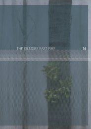
The township of Redesdale is on <strong>the</strong> Kyneton–Heathcote road, south of Lake Eppalock. It is 95 kilometres<br />
north-west of Melbourne and 35 kilometres south-east of Bendigo.<br />
The Redesdale <strong>fire</strong> was reported at 15:<strong>11</strong> on 7 February <strong>2009</strong> and burned towards <strong>the</strong> south-east for about<br />
19 kilometres. After <strong>the</strong> south-westerly wind change arrived at 18:35, <strong>the</strong> <strong>fire</strong> turned to <strong>the</strong> north and north-east.<br />
It affected four municipalities—Greater Bendigo, Mount Alexander, Macedon Ranges and Mitchell—destroying<br />
14 houses and burning 7,086 hectares. It was <strong>the</strong> first of two <strong>fire</strong>s in <strong>the</strong> region on that day, <strong>the</strong> second originating<br />
in Maiden Gully, 8 kilometres north-west of Bendigo, at 16:20. Figure <strong>11</strong>.1 shows <strong>the</strong> extent of <strong>the</strong> Redesdale <strong>fire</strong>.<br />
Overview<br />
Maximum temperature<br />
Minimum relative humidity<br />
Wind<br />
The maximum temperature recorded was 44.7°C at Redesdale automatic wea<strong>the</strong>r<br />
station at 16:00. 1<br />
The minimum relative humidity recorded was 7 per cent at Redesdale AWS between<br />
16:00 and 17:30. 2<br />
The maximum winds recorded before <strong>the</strong> wind change were north-north-westerly<br />
at 50 kilometres an hour at Redesdale AWS at 15:30. 3<br />
The wind change was recorded by <strong>the</strong> Redesdale AWS at 18:35 at 39 kilometres<br />
an hour. 4<br />
The maximum winds recorded after <strong>the</strong> wind change were south-westerly<br />
at 42 kilometres an hour at Redesdale AWS at 19:00. 5<br />
Fire Danger Index The maximum Fire Danger Index was 87.2 at Redesdale AWS at 16:00. 6<br />
Cause Undetermined. 7<br />
Fatalities No fatalities. 8<br />
Casualties One casualty. 9<br />
Houses destroyed Fourteen houses. 10<br />
Overall area burnt 7,086 hectares. <strong>11</strong><br />
Firefighting resources<br />
On 7 February, 536 CFA and 127 NEO personnel attended <strong>the</strong> <strong>fire</strong>. They were<br />
supported by 103 CFA appliances, 21 NEO dozers and 1 aircraft. 12<br />
170
The Redesdale <strong>fire</strong><br />
Figure <strong>11</strong>.1 The Redesdale <strong>fire</strong><br />
Mia Mia<br />
Flagstafe<br />
Reservoir<br />
Redesdale<br />
Redesdale<br />
14:15<br />
MISSION HILL ROAD<br />
Metcalfe East<br />
Barfold<br />
Glenhope<br />
Sidonia<br />
Final Fire Perimeter<br />
Roads<br />
Redesdale<br />
Baynton<br />
MISSION HILL ROAD<br />
N Final <strong>fire</strong> perimeter<br />
Roads<br />
Rivers/creeks<br />
Fire Spread<br />
Fire Origin<br />
MIA MIA-LANCEFIELD ROAD<br />
WATCHBOX ROAD<br />
SIDONIA ROAD<br />
0 1 2 3 4 5 Kilometres<br />
NORTH REDESDALE<br />
ROAD<br />
MT LOFTY ROAD<br />
BENDIGO-REDESDALE ROAD<br />
HEATHCOTE-KYNETON ROAD<br />
RACECOURSE ROAD<br />
MYRTLE<br />
CREEK<br />
ROAD<br />
SUTTON GRANGE-REDESDALE ROAD<br />
JENNINGS HILL ROAD<br />
COLIBAN PARK ROAD<br />
BLACKFELLOWS GATE ROAD<br />
METCALFE-REDESDALE ROAD<br />
TRIANGLE ROAD<br />
METCALFE-ELPHINSTONE ROAD<br />
Metcalfe<br />
KYNETON-METCALFE ROAD<br />
CALDER FREEWAY<br />
171<br />
Source: Exhibit 994 – Redesdale Fire – Final Fire Perimeter. 13
Volume I: The Fires and <strong>the</strong> Fire-Related Deaths<br />
Redesdale<br />
7 February – 14 February<br />
The following time line summarises events associated with <strong>the</strong> Redesdale <strong>fire</strong>. For <strong>the</strong> most part, <strong>the</strong> times<br />
given are approximate. Fur<strong>the</strong>r details about <strong>the</strong> events are provided in <strong>the</strong> accompanying narrative.<br />
Pre-designated<br />
Incident Controller<br />
arrives at Epsom ICC<br />
15:12<br />
Redesdale<br />
brigade paged<br />
Fire reported<br />
to CFA<br />
15:37<br />
Awareness<br />
message<br />
issued<br />
15:30<br />
Epsom ICC<br />
advised <strong>fire</strong> is<br />
out of control<br />
First urgent threat<br />
message issued<br />
7 February<br />
08:30 <strong>11</strong>:00 15:<strong>11</strong> 15:57<br />
IMT in<br />
readiness at<br />
Epsom ICC<br />
15:20<br />
Fire crosses<br />
Metcalfe–<br />
Redesdale road<br />
Local resident<br />
calls 000<br />
15:43<br />
Additional 40<br />
trucks sent to<br />
<strong>fire</strong> ground<br />
15:47<br />
Request<br />
made to close<br />
Heathcote–<br />
Kyneton road<br />
172
The Redesdale <strong>fire</strong><br />
Mobile operations point<br />
established next to<br />
Redesdale Town Hall<br />
First local wea<strong>the</strong>r<br />
forecast requested<br />
17:40<br />
Reconnaissance<br />
aircraft takes off from<br />
Bendigo airport<br />
Request for army<br />
graders cancelled:<br />
threat subsiding<br />
16:00 17:30 18:35 20:00<br />
8 February 14 February<br />
Red flag<br />
warning issued<br />
South-westerly<br />
wind change<br />
moves through<br />
<strong>fire</strong> ground<br />
07:00<br />
Fire controlled<br />
Fire completely<br />
blacked out.<br />
173
Volume I: The Fires and <strong>the</strong> Fire-Related Deaths<br />
<strong>11</strong>.1 Sequence of Events<br />
<strong>11</strong>.1.1<br />
Preparation<br />
On 6 February Mr John Deering, Operations Manager of Country Fire Authority Region 2, and Mr Andrew Mat<strong>the</strong>ws,<br />
<strong>the</strong> Department of Sustainability and Environment acting Area Land and Fire Manager, established a joint level 3<br />
incident management team at <strong>the</strong> Epsom Incident Control Centre, for a ‘hot start’ <strong>the</strong> following day. Many of <strong>the</strong><br />
IMT members selected for <strong>the</strong> hot start were at <strong>the</strong> ICC on 6 February and used that day to test and confirm ground<br />
observer arrangements and begin <strong>fire</strong> behaviour prediction work. Those present also participated in a practice<br />
scenario involving a multi-agency response to a level 3 <strong>fire</strong>. 14<br />
On <strong>the</strong> morning of 7 February Mr Deering and his DSE counterpart, Mr James Dalton, ensured that all units in <strong>the</strong><br />
IMT were preparing for <strong>the</strong> day ahead. For example, <strong>the</strong> Planning Section carried out <strong>fire</strong> behaviour predictions and<br />
ensured that <strong>the</strong> ground observer team was in place; <strong>the</strong> Information Unit prepared templates for <strong>fire</strong> information<br />
releases and established contact with <strong>the</strong> ABC and local media. A fully staffed IMT was ready from <strong>11</strong>:00 on<br />
7 February. Mr Deering arrived at 08:30 that day and took a joint leadership role with Mr Dalton. Both were<br />
accredited level 3 Incident Controllers. 15<br />
Superintendent Peter Bull was <strong>the</strong> Divisional Emergency Response Coordinator for <strong>the</strong> division, which takes in <strong>the</strong><br />
municipalities of Greater Bendigo, Mount Alexander and Macedon Ranges. By Friday 6 February he had ascertained<br />
that each of <strong>the</strong>se municipalities was prepared to activate its Municipal Emergency Coordination Centre if required. 16<br />
Table <strong>11</strong>.1 summarises <strong>the</strong> state of preparedness for <strong>the</strong> Redesdale <strong>fire</strong>.<br />
Table <strong>11</strong>.1 The Redesdale <strong>fire</strong> – IMT preparedness<br />
Pre-designated level 3 ICC Yes 17<br />
Pre-formed IMT at ICC Yes 18<br />
Pre-identified level 3 IC Yes 19<br />
Pre-identified IMT members Yes 20<br />
Time <strong>fire</strong> started Approx 15:<strong>11</strong> 21<br />
Full IMT in place by <strong>11</strong>:00, 7 February <strong>2009</strong> 22<br />
Safety adviser appointed No 23<br />
<strong>11</strong>.1.2<br />
7 February<br />
Origin and cause<br />
VicFire was notified of <strong>the</strong> <strong>fire</strong> at Redesdale at 15:<strong>11</strong> on 7 February. The <strong>fire</strong> was initially reported to have started<br />
at Coliban Park Road, about 2 kilometres to <strong>the</strong> west of Redesdale on <strong>the</strong> western side of <strong>the</strong> Coliban River.<br />
Fire investigators subsequently discovered that <strong>the</strong> <strong>fire</strong> actually started on <strong>the</strong> eastern side of <strong>the</strong> river. 24<br />
Ms Samantha Siddle lives on a property at Racecourse Road, Redesdale, very close to <strong>the</strong> <strong>fire</strong>’s point of origin.<br />
Ms Siddle first smelled smoke at around 15:00. She got into her car and drove across her property in search of <strong>the</strong><br />
origin of <strong>the</strong> smoke. Within about 15 minutes, however, her paddocks were on <strong>fire</strong>. At 15:20, having returned to her<br />
home, she called 000 to report <strong>the</strong> <strong>fire</strong>. 25<br />
DSE <strong>fire</strong> tower observers in <strong>the</strong> Mount Ida and Fryers Ridge <strong>fire</strong> towers also saw <strong>the</strong> <strong>fire</strong> soon after it had started. 26<br />
174<br />
Victoria Police has investigated <strong>the</strong> cause of ignition of <strong>the</strong> Redesdale <strong>fire</strong> but has made no determination. 27
The Redesdale <strong>fire</strong><br />
Fire run, response and management<br />
At 15:12 <strong>the</strong> Redesdale, Metcalfe, Sutton Grange and Langley–Barfold brigades were sent to attend <strong>the</strong> <strong>fire</strong>.<br />
The ground observer crew that had been pre-positioned on 6 February was also promptly dispatched. Nine minutes<br />
after <strong>the</strong> initial report <strong>the</strong> <strong>fire</strong> crossed <strong>the</strong> Metcalfe–Redesdale road. 28<br />
Mr Peter Wilson, Group Officer with <strong>the</strong> CFA Metcalfe group, was <strong>the</strong> initial level 1 Incident Controller at <strong>the</strong> <strong>fire</strong><br />
ground. The Epsom IMT shadowed <strong>the</strong> first response, preparing to assume control on <strong>the</strong> basis that <strong>the</strong> first attack<br />
was unlikely to succeed. At 15:30 Mr Wilson telephoned to advise <strong>the</strong> ICC that <strong>the</strong> <strong>fire</strong> was beyond <strong>the</strong> control of<br />
<strong>the</strong> initial resources of <strong>the</strong> responding brigades and asked that <strong>the</strong> Epsom IMT assume control. From that time until<br />
about 09:00 <strong>the</strong> following day Mr Deering was <strong>the</strong> level 3 Incident Controller. 29<br />
Shortly after 15:25 Mr Andrew Chapman, captain of <strong>the</strong> Elphinstone brigade, went to <strong>the</strong> Elphinstone <strong>fire</strong> station,<br />
where he learnt of <strong>the</strong> Redesdale <strong>fire</strong>. One of <strong>the</strong> first to arrive at <strong>the</strong> <strong>fire</strong>, he intended to set up a control point at<br />
<strong>the</strong> corner of <strong>the</strong> Kyneton–Redesdale road and Siddles Road. While on his way <strong>the</strong>re he realised that <strong>the</strong> <strong>fire</strong> had<br />
travelled past this point and was out of control. The control point was eventually established with Deputy Group<br />
Officer Mr Dave Penno at <strong>the</strong> Heathcote–Kyneton road and Perry’s Lane intersection. 30<br />
The first alert <strong>the</strong> Elphinstone brigade received came at about 15:26, while Mr Chapman was on his way towards<br />
<strong>the</strong> <strong>fire</strong>. The Mia Mia brigade also received this alert. 31<br />
At <strong>the</strong> ICC Mr Deering was not directly involved in decisions about allocation of resources on <strong>the</strong> <strong>fire</strong> ground. He left<br />
those tactical decisions to <strong>the</strong> commanders in <strong>the</strong> field, conceiving his role as more strategic. He and Mr Dalton had<br />
discussed beforehand how <strong>the</strong>y would work toge<strong>the</strong>r: Mr Dalton took responsibility for internal management of <strong>the</strong><br />
IMT and Mr Deering concentrated on external relationships, including keeping <strong>the</strong> integrated Emergency Control<br />
Centre and <strong>the</strong> public informed. 32<br />
On becoming aware of <strong>the</strong> <strong>fire</strong> at Redesdale <strong>the</strong> Epsom ICC information officer prepared an awareness message<br />
for <strong>the</strong> communities of Metcalfe, Metcalfe East, Barfold, Langley and Redesdale, distributing it by email at 15:37.<br />
The message was broadcast on 774 ABC radio at 15:50 and on ABC Bendigo at 15:53. 33<br />
Thirty additional tankers were requested at 15:43; 40 appliances eventually attended <strong>the</strong> <strong>fire</strong>. At 15:47 Superintendent<br />
Bull received a request from DSE to close <strong>the</strong> Heathcote–Kyneton road. 34<br />
Police working independently of each o<strong>the</strong>r operated roadblocks to <strong>the</strong> north and south of <strong>the</strong> <strong>fire</strong>. Communications<br />
between <strong>the</strong> Epsom ICC and police to <strong>the</strong> north of <strong>the</strong> <strong>fire</strong> were better than those with police to <strong>the</strong> south, who had<br />
great difficulty tracking <strong>the</strong> <strong>fire</strong>’s progress because of a lack of information and received no requests to establish<br />
roadblocks. In some cases residents wanting to return to <strong>the</strong>ir properties managed to bypass road closures, gaining<br />
access to <strong>the</strong>ir properties via back roads and tracks. 35<br />
When <strong>the</strong> <strong>fire</strong> was first reported Mr John Cutting, manager of <strong>the</strong> Bendigo Regional Emergency Coordination<br />
Centre on 7 February, immediately sent Mr Craig Brittain, CFA Operations Officer, to <strong>the</strong> <strong>fire</strong> ground; Mr Brittain was<br />
accompanied by Mr Andrew Gill as his deputy. The two men arrived at <strong>the</strong> <strong>fire</strong> within 40 minutes and made contact<br />
with Mr Chapman. 36<br />
Mr Chapman briefed <strong>the</strong>m both, and toge<strong>the</strong>r <strong>the</strong>y formulated a strategy, sectorised <strong>the</strong> <strong>fire</strong> and appointed three<br />
senior CFA volunteers as sector commanders. 37<br />
Superintendent Bull was already at <strong>the</strong> Epsom ICC when <strong>the</strong> Redesdale <strong>fire</strong> began, and for a period he performed<br />
<strong>the</strong> roles of police liaison, command operations and Divisional Emergency Response Coordinator simultaneously.<br />
He promptly relayed <strong>the</strong> ICC’s requests for tankers and graders to Sergeant Grant Morris, <strong>the</strong> Bendigo Municipal<br />
Emergency Response Coordinator. Sergeant Morris sent <strong>the</strong> requests to <strong>the</strong> Municipal Emergency Resource Officer<br />
for Greater Bendigo, who arranged for <strong>the</strong> equipment to be provided. 38<br />
Just over 6 kilometres from <strong>the</strong> <strong>fire</strong>’s point of origin, and before 16:00, <strong>the</strong> <strong>fire</strong> crossed <strong>the</strong> Kyneton–Redesdale<br />
road in several places before reaching <strong>the</strong> community of Barfold. It was deemed too dangerous to attack <strong>the</strong> head<br />
of <strong>the</strong> <strong>fire</strong>, so <strong>the</strong> majority of resources were concentrated on its eastern flank. The Bendigo Regional Emergency<br />
Coordination Centre redirected to <strong>the</strong> Redesdale <strong>fire</strong> two strike teams that had been assembled in CFA Region 2<br />
to respond to <strong>the</strong> Kilmore East <strong>fire</strong>. 39<br />
175
Volume I: The Fires and <strong>the</strong> Fire-Related Deaths<br />
An emergency relief centre was established at <strong>the</strong> Redesdale community hall soon after <strong>the</strong> <strong>fire</strong> started, and Sergeant<br />
Morris was advised of <strong>the</strong> establishment of an evacuation centre at Barrack Reserve at Heathcote. 40<br />
At about 16:00 an operations point was established in a mobile control vehicle. The <strong>fire</strong> crossed Watchbox Road<br />
at about 16:49. 41<br />
Mr Andrew Howlett, <strong>the</strong> Epsom ICC planning officer, asked for local wea<strong>the</strong>r forecasts at 16:00 and at 17:00.<br />
The Bureau of Meteorology issued <strong>the</strong> forecasts within 30 minutes of <strong>the</strong> request being received, and <strong>the</strong> forecasts<br />
were passed on to <strong>the</strong> Operations Unit and <strong>the</strong> information officers. Fire prediction maps were produced in <strong>the</strong><br />
Epsom ICC at 15:55, 18:14 and 20:<strong>11</strong> and were projected onto a screen for everyone in <strong>the</strong> IMT to see. 42<br />
The first urgent threat message was issued at 15:57; subsequent threat messages were prepared, distributed and<br />
broadcast in a timely manner on 7 February, telling local communities of <strong>the</strong> <strong>fire</strong>’s location and <strong>the</strong> timing and impact<br />
of <strong>the</strong> wind change. 43<br />
Dozers and graders, supported by slip-on units and tankers, were used to establish containment lines along <strong>the</strong><br />
north-eastern flank of <strong>the</strong> <strong>fire</strong>. Mr Brittain asked that graders create a <strong>fire</strong>break in front of Redesdale township.<br />
More work was done near Mia Mia; this work was limited by difficult terrain, but crews were able to establish<br />
effective containment lines along most of <strong>the</strong> <strong>fire</strong>’s north-eastern flank before <strong>the</strong> wind changed. Tanker crews<br />
were unable to attack <strong>the</strong> head of <strong>the</strong> <strong>fire</strong> before <strong>the</strong> wind change and instead supported <strong>the</strong> crews by direct<br />
attack on <strong>the</strong> flanks of <strong>the</strong> <strong>fire</strong>, building containment lines, and assisting with protection of property. 44<br />
It is apparent from log entries made by Mr Howlett and Mr Leslie Vearing, <strong>the</strong> operations officer at <strong>the</strong> Epsom ICC,<br />
that both <strong>the</strong> Planning Unit and <strong>the</strong> Operations Unit became aware shortly before 17:30 that <strong>the</strong> forecast wind<br />
change would arrive between 18:30 and 19:00. Within minutes a red flag warning was transmitted from <strong>the</strong> Epsom<br />
ICC to <strong>the</strong> Redesdale operations point and passed on to all stations on <strong>the</strong> <strong>fire</strong> ground. 45<br />
Mr Robert Jarvis of Parks Victoria had been on standby at Bendigo airport as air attack supervisor for <strong>the</strong> Epsom ICC.<br />
By 17:40 <strong>the</strong> wind had begun to moderate and he was able to take off in his aircraft and do some reconnaissance<br />
in <strong>the</strong> area of <strong>the</strong> <strong>fire</strong>. Mr Jarvis provided to Mr Vearing information about <strong>the</strong> location of <strong>the</strong> head of <strong>the</strong> <strong>fire</strong> and <strong>the</strong><br />
nor<strong>the</strong>rn flank. He was hampered in his work, however, by extreme turbulence and poor visibility. He was on approach<br />
to Bendigo airport when <strong>the</strong> wind changed. 46<br />
At 17:46, <strong>the</strong> incident management team produced an incident action plan summary, which detailed where <strong>the</strong> <strong>fire</strong><br />
was, where it was travelling, <strong>the</strong> towns it was near and <strong>the</strong> incident management team’s objectives—to protect life<br />
and assets in <strong>the</strong> <strong>fire</strong> area and track and hold <strong>the</strong> eastern edge of <strong>the</strong> <strong>fire</strong> ahead of <strong>the</strong> wind change. The summary<br />
also detailed <strong>the</strong> means by which <strong>the</strong> eastern edge was to be held. 47<br />
By 18:00 <strong>the</strong> <strong>fire</strong> had reached <strong>the</strong> locality of Sidonia, where it burnt a number of private blue-gum plantations. 48<br />
Between 18:35 and 18:46 <strong>the</strong> south-westerly wind change moved through <strong>the</strong> <strong>fire</strong> ground, pushing <strong>the</strong> eastern<br />
flank of <strong>the</strong> <strong>fire</strong> towards <strong>the</strong> communities of Redesdale, Mia Mia and Heathcote. The <strong>fire</strong>fighters’ efforts to secure<br />
<strong>the</strong> north-eastern flank of <strong>the</strong> <strong>fire</strong> during <strong>the</strong> afternoon proved effective, and <strong>the</strong> <strong>fire</strong> did not reach <strong>the</strong>se communities.<br />
Once <strong>the</strong> wind change had passed, wea<strong>the</strong>r conditions eased and <strong>fire</strong>fighters were able to attack <strong>the</strong> <strong>fire</strong> directly on<br />
all flanks. 49<br />
Soon after 20:00 Mr Vearing was sufficiently confident that <strong>the</strong> <strong>fire</strong> would be contained overnight to cancel an<br />
earlier request that <strong>the</strong> Army provide graders. He decided DSE did not need to allocate any fur<strong>the</strong>r resources<br />
to <strong>the</strong> Redesdale <strong>fire</strong>. 50<br />
176<br />
Residents and <strong>fire</strong>fighters in <strong>the</strong> area affected by <strong>the</strong> Redesdale <strong>fire</strong> do not appear to have experienced <strong>the</strong> difficulties<br />
and frustrations with police roadblocks that were experienced in o<strong>the</strong>r areas. 51 This could be because <strong>the</strong> Redesdale<br />
<strong>fire</strong> burned largely in open country and was brought under control relatively quickly.<br />
The <strong>fire</strong>’s average rate of spread was 6 kilometres an hour. During <strong>the</strong> course of <strong>the</strong> afternoon <strong>the</strong> <strong>fire</strong> spread rapidly<br />
though grassland, at up to 12 kilometres an hour, while slowing to as low as 1 kilometre an hour in areas of heavy fuel<br />
and forest. 52
The Redesdale <strong>fire</strong><br />
The Redesdale <strong>fire</strong> was controlled by 07:00 on 8 February, although in <strong>the</strong> following days <strong>the</strong>re were some break-outs<br />
as a result of strong sou<strong>the</strong>rly winds. During this time <strong>fire</strong>fighters continued to secure <strong>the</strong> <strong>fire</strong> perimeter; this involved<br />
redeploying resources from <strong>the</strong> nearby Bendigo <strong>fire</strong>. The <strong>fire</strong> was not listed as contained until 09:56 on 10 February.<br />
It was completely blacked out by 14 February. 53<br />
As noted, <strong>the</strong> Redesdale <strong>fire</strong> burned in four separate municipalities. It started in <strong>the</strong> City of Greater Bendigo, burned<br />
mainly in Mount Alexander Shire, and extended to Mitchell and Macedon Ranges Shires. 54<br />
The <strong>fire</strong> was observed as a ‘blanket of <strong>fire</strong>’ spreading across <strong>the</strong> landscape, with a flame front 20 metres deep and<br />
a flame height of 1 to 2 metres over grassland. It developed into a crown <strong>fire</strong> in some forested areas, including in <strong>the</strong><br />
Mt Lofty reserve. 55<br />
Fourteen houses and more than 50 sheds and outbuildings were destroyed, as were <strong>the</strong> Baynton church, a bridge,<br />
two olive plantations and a vineyard. Two CFA forward control vehicles were damaged. 56<br />
<strong>11</strong>.2 Conclusions<br />
The efficient way in which information was ga<strong>the</strong>red and shared by <strong>the</strong> incident management team enabled<br />
assessment of communities at risk, prompt preparation and distribution of informative warnings, and <strong>the</strong> setting<br />
up of appropriate road closures. Most crucially, it allowed <strong>the</strong> IMT to develop <strong>the</strong> <strong>fire</strong>fighting strategy, which involved<br />
a concentrated effort to secure <strong>the</strong> north-eastern flank before <strong>the</strong> wind change, thus improving <strong>the</strong> protection of<br />
<strong>the</strong> Redesdale, Mia Mia and Heathcote communities fur<strong>the</strong>r to <strong>the</strong> north-east. This approach was finalised within<br />
an hour of <strong>the</strong> Epsom ICC assuming control of <strong>the</strong> incident and was effectively implemented in <strong>the</strong> two hours before<br />
<strong>the</strong> wind change arrived. 57<br />
In <strong>the</strong> <strong>Commission</strong>’s view, <strong>the</strong> Epsom IMT’s effective management of <strong>the</strong> Redesdale <strong>fire</strong> is testament to good planning<br />
and agency cooperation in <strong>the</strong> lead-up to a day of extreme <strong>fire</strong> danger—in particular pre-positioning properly qualified<br />
and experienced staff in an IMT. It also highlights <strong>the</strong> value of focusing on ga<strong>the</strong>ring and sharing information within <strong>the</strong><br />
IMT, between <strong>fire</strong> agencies and with <strong>the</strong> public.<br />
Fire agencies’ response to <strong>the</strong> Redesdale <strong>fire</strong> was, however, impeded by communication difficulties. Radio<br />
communications between Redesdale divisional command and <strong>the</strong> <strong>fire</strong> ground were poor. Mobile telephone<br />
communications were intermittent, and ground observers were unable to transmit information electronically via<br />
broadband internet connection. At times Mr Brittain was unable to make contact with sector commanders, and<br />
it was necessary to bring <strong>the</strong>m to <strong>the</strong> operations point at Redesdale for briefings. Mr Brittain attributed <strong>the</strong>se<br />
difficulties to various causes, among <strong>the</strong>m <strong>the</strong> topography of <strong>the</strong> area, heat and smoke, and radio black spots. 58<br />
Communications issues are considered in more detail in Chapter 3 of Volume II.<br />
Members of Victoria Police responding to <strong>the</strong> Redesdale <strong>fire</strong> also had problems with radio communications.<br />
Although <strong>the</strong>y appear to have had better radio reception than CFA members, <strong>the</strong>ir communications were impeded<br />
by <strong>the</strong> high volume of radio traffic directed through <strong>the</strong> police communications network, D24. 59<br />
The <strong>Commission</strong> heard evidence that Mount Alexander and Macedon Ranges Shires provided a great deal<br />
of support, considering that Greater Bendigo and Mitchell Shires were fully occupied with o<strong>the</strong>r <strong>fire</strong>s in <strong>the</strong>ir<br />
municipalities. The detail of <strong>the</strong> emergency response within <strong>the</strong> Mount Alexander and Macedon Ranges Shires is,<br />
however, largely unknown because no statements were provided to <strong>the</strong> <strong>Commission</strong> for <strong>the</strong> Municipal Emergency<br />
Response Coordinator and Municipal Emergency Resource Officers for those municipalities. 60<br />
1 Exhibit 557 – Meteorological Aspects of <strong>the</strong> Redesdale Fire (BOM.901.0213) at 0227<br />
2 Exhibit 557 – Meteorological Aspects of <strong>the</strong> Redesdale Fire (BOM.901.0213) at 0227<br />
3 Exhibit 557 – Meteorological Aspects of <strong>the</strong> Redesdale Fire (BOM.901.0213) at 0227<br />
4 Exhibit 557 – Meteorological Aspects of <strong>the</strong> Redesdale Fire (BOM.901.0213) at 0227<br />
5 Exhibit 557 – Meteorological Aspects of <strong>the</strong> Redesdale Fire (BOM.901.0213) at 0227<br />
177
Volume I: The Fires and <strong>the</strong> Fire-Related Deaths<br />
178<br />
6 Exhibit 4 – Supplementary Statement of Rees (WIT.004.002.0001) [<strong>11</strong>2]<br />
7 Exhibit 462 – Statement of Kelleher (VPO.001.027.0175) at 0177–0178<br />
8 Exhibit 3 – Statement of Rees (WIT.004.001.0001) at 0106<br />
9 Exhibit 215 – Supplementary Statement of Hollowood (WIT.3010.003.0287_R) [21]<br />
10 Exhibit 980 – Correspondence – Houses Destroyed – Breakdown by Fire (CORR.1003.0048_R) at 0048_R<br />
<strong>11</strong> Exhibit 786 – Statement of Clow (WIT.3004.034.0004) [19.10]<br />
12 Exhibit 939 – Details Regarding Emergency Response (CFA.600.005.0195) at 0195, 0198; Exhibit 939 – Day by Day breakdown – Redesdale<br />
(DSE.HDD.0048.0545_16); Exhibit 939 – Aircraft data 0809 (DSE.HDD.0048.0544_20) at 0544_27<br />
13 Exhibit 994 – Redesdale Fire – Final Fire Perimeter (CFA.600.006.0004)<br />
14 Exhibit 452 – Statement of Deering (WIT.3004.019.0192) [25], [29], Annexure 6 (WIT.3004.019.0272) at 0272; Exhibit 460 – Statement<br />
of Cutting (WIT.3004.020.0001) [21]; Exhibit 466 – Statement of Vearing (WIT.3024.004.0215) [15]; Exhibit 458 – Statement of Gilmore<br />
(WIT.3004.019.0001) [12]<br />
15 Exhibit 452 – Statement of Deering (WIT.3004.019.0192) [5], [35]; Exhibit 466 – Statement of Vearing, Annexure 4 (DSE.HDD.0052.0651)<br />
at 0687; Deering T10151:13–T10151:18<br />
16 Exhibit 454 – Statement of Bull (WIT.3010.009.0001) [<strong>11</strong>], Attachment 6 (WIT.3010.009.0057)<br />
17 Exhibit 452 – Statement of Deering (WIT.3004.019.0192) [23]–[25], [29], Annexure 5 (WIT.3004.019.0269), Annexure 6 (WIT.3004.019.0272)<br />
at 0272; Exhibit 466 – Statement of Vearing (WIT.3024.004.0215) [15], [17]; Exhibit 460 – Statement of Cutting (WIT.3004.020.0001) [21];<br />
Exhibit 458 – Statement of Gilmore (WIT.3004.019.0001) [12]<br />
18 Exhibit 452 – Statement of Deering (WIT.3004.019.0192) [5], [23]–[26], [29], Annexure 5 (WIT.3004.019.0269), Annexure 6 (WIT.3004.019.0272)<br />
at 0272; Exhibit 466 – Statement of Vearing (WIT.3024.004.0215) [15], [17], Annexure 4 (DSE.HDD.0052.0651) at 0687; Exhibit 460 – Statement<br />
of Cutting (WIT.3004.020.0001) [21]; Exhibit 458 – Statement of Gilmore (WIT.3004.019.0001) [12]<br />
19 Exhibit 452 – Statement of Deering (WIT.3004.019.0192) [5], [26], [35]–[38], Annexure 5 (WIT.3004.019.0269) at 0269; Exhibit 466 –<br />
Statement of Vearing, Annexure 4 (DSE.HDD.0052.0651) at 0687; Exhibit 458 – Statement of Gilmore (WIT.3004.019.0001) [17]; Deering<br />
T10151:13–T10151:18, T10152:9–T10152:22<br />
20 Exhibit 452 – Statement of Deering (WIT.3004.019.0192) [5], [23]–[26], [29], Annexure 5 (WIT.3004.019.0269), Annexure 6 (WIT.3004.019.0272)<br />
at 0272; Exhibit 466 – Statement of Vearing (WIT.3024.004.0215) [15], [17], Annexure 4 (DSE.HDD.0052.0651) at 0687; Exhibit 460 – Statement<br />
of Cutting (WIT.3004.020.0001) [21]; Exhibit 458 – Statement of Gilmore (WIT.3004.019.0001) [12]<br />
21 Exhibit 462 – Statement of Flett (VPO.001.027.0169) at 0171; Deering T9958:<strong>11</strong>–T9958:16<br />
22 Exhibit 452 – Statement of Deering (WIT.3004.019.0192) [5], [26], Annexure 5 (WIT.3004.019.0269) at 0269; Exhibit 466 – Statement of Vearing,<br />
Annexure 4 (DSE.HDD.0052.0651) at 0687; Deering T10151:13–T10151:18<br />
23 Exhibit 548 – Correspondence – Safety Advisors (CORR.09<strong>11</strong>.0107_R)<br />
24 Exhibit 466 – Statement of Vearing (WIT.3024.004.0215) [28]; Exhibit 2 – IMS Data (WIT.004.002.1459) at 1512; Exhibit 441 – Map of Redesdale<br />
(TEN.<strong>11</strong>9.001.0002); Exhibit 462 – Statement of Flett (VPO.001.027.0169) at 0170; Brittain T9971:31–T9972:4<br />
25 Exhibit 459 – Statement of Siddle (WIT.<strong>11</strong>5.001.0001_R) [12]–[18]; Siddle T10290:18–T10292:21<br />
26 Exhibit 452 – Statement of Deering (WIT.3004.019.0192) [46]; Exhibit 462 – Incident Information Summary – Redesdale Fire<br />
(TEN.129.001.0002); Exhibit 94 – Land and Fire Areas and Fire Towers (DOC.VGS.002.0001)<br />
27 Exhibit 462 – Statement of Kelleher (VPO.001.027.0175) at 0177–0178<br />
28 Exhibit 452 – Statement of Deering (WIT.3004.019.0192) [36], [46]; Exhibit 462 – Statement of Booker (SUMM.044.002.0277) at 0277–<br />
0278; Exhibit 468 – Statement of Howlett (WIT.3004.020.0289) [35]; Exhibit 22 – Statement of Williams, Annexure 1 (WIT.013.001.0012)<br />
at 0194–0195, 0210–02<strong>11</strong>; Exhibit 453 – Fire Prediction Maps (TEN.127.001.0001); Deering T9960:3–T9960:10, T10151:23–T10152:8,<br />
T10153:14–T10153:15, T10159:5–T10161:13<br />
29 Exhibit 458 – Statement of Gilmore (WIT.3004.019.0001) [31]; Exhibit 452 – Statement of Deering (WIT.3004.019.0192) [40];<br />
Deering T9960:<strong>11</strong>–T9960:15<br />
30 Exhibit 462 – Statement of Chapman (SUMM.044.002.0109) at 0109–0<strong>11</strong>1<br />
31 Exhibit 462 – Statement of Chapman (SUMM.044.002.0109) at 0109<br />
32 Exhibit 452 – Statement of Deering (WIT.3004.019.0192) [75]; Deering T10154:4–T10154:27<br />
33 Exhibit 469 – Statement of Downes (WIT.3004.020.0314) [19]–[20], Annexure 5 (WIT.3004.020.0340); Exhibit 452 – Statement of Deering<br />
(WIT.3004.019.0192) [77], Annexure 10 (WIT.3004.019.0324); Exhibit 144 – ABC Local Radio – Disc 1 (TEN.052.001.0001); Exhibit 7 –<br />
Transcript – 774 ABC Radio (SUMM.001.002.0001) at 0290–0291<br />
34 Exhibit 460 – Statement of Cutting (WIT.3004.020.0001) [35], [39]–[40], [45]; Exhibit 439 – Statement of Brittain (WIT.3004.020.0251) [30];<br />
Exhibit 454 – Statement of Bull (WIT.3010.009.0001) [19]; Brittain T9974:30–T9975:3; Cutting T10321:28–T10322:1; Deering T9960:23–T9960:31<br />
35 Exhibit 454 – Statement of Bull (WIT.3010.009.0001) [29]–[30]; Exhibit 473 – Statement of Brundell (WIT.3010.006.0215) [14], [20]–[22];<br />
Exhibit 439 – Statement of Brittain (WIT.3004.020.0251) [72]–[74]<br />
36 Exhibit 439 – Statement of Brittain (WIT.3004.020.0251) [25], [28]–[29], [31], [35]; Brittain T9970:17–T9971:<strong>11</strong>, T9972:5–T9973:20;<br />
Exhibit 462 – Statement of Chapman (SUMM.044.002.0109) at 0<strong>11</strong>1<br />
37 Exhibit 439 – Statement of Brittain (WIT.3004.020.0251) [38], Annexure 5 (WIT.3004.020.0274); Brittain T9974:5–T9974:21<br />
38 Exhibit 454 – Statement of Bull (WIT.3010.009.0001) [28]–[29]; Bull T10172:17–T10172:31; Exhibit 464 – Statement of Morris<br />
(WIT.3010.007.0298) [21]–[22]; Exhibit 465 – Statement of Malone (WIT.4010.001.0001) [60]<br />
39 Exhibit 460 – Statement of Cutting (WIT.3004.020.0001) [35], [39]–[40], [45]; Exhibit 439 – Statement of Brittain (WIT.3004.020.0251) [30];<br />
Cutting T10321:28–T10322:1; Deering T9960:23–T9960:31; Brittain T9974:30–T9975:3
The Redesdale <strong>fire</strong><br />
40 Exhibit 439 – Statement of Brittain (WIT.3004.020.0251) [43]; Exhibit 464 – Statement of Morris (WIT.3010.007.0298) [31]<br />
41 Exhibit 439 – Statement of Brittain (WIT.3004.020.0251) [45]; Exhibit 466 – Statement of Vearing (WIT.3024.004.0215) [33];<br />
Deering T9961:3–T9961:12, T9962:15–T9962:16; Brittain T9975:2–T9975:25<br />
42 Exhibit 468 – Statement of Howlett (WIT.3004.020.0289) [35]; Exhibit 22 – Statement of Williams, Annexure 1 (WIT.013.001.0012) at 0194–<br />
0195, 0210–02<strong>11</strong>; Exhibit 453 – Fire Prediction Maps (TEN.127.001.0001); Deering T10159:5–T10161:13<br />
43 Exhibit 469 – Statement of Downes (WIT.3004.020.0314) [23], [26], [31], [35], [37]; Exhibit 144 – ABC Local Radio – Disc 1 (TEN.052.001.0001);<br />
Exhibit 452 – Statement of Deering (WIT.3004.019.0192) [76]–[94]; Exhibit 7 – Transcript – 774 ABC Radio (SUMM.001.002.0001)<br />
44 Exhibit 439 – Statement of Brittain (WIT.3004.020.0251) [46], [49]–[50]; Exhibit 466 – Statement of Vearing (WIT.3024.004.0215) [40]–[42]<br />
45 Exhibit 468 – Statement of Howlett, Annexure 3 (WIT.3004.020.0305) at 0307; Exhibit 466 – Statement of Vearing, (WIT.3024.004.0215)<br />
[45], Annexure 5 (DSE.HDD.0052.0793) at 0794, Annexure 6 (DSE.HDD.0052.0745) at 0748; Exhibit 439 – Statement of Brittain, Annexure 6<br />
(WIT.3004.020.0276)<br />
46 Exhibit 463 – Statement of Jarvis (VPO.001.012.0032) at 0032–0033; Exhibit 466 – Statement of Vearing (WIT.3024.004.0215) [43], [48]<br />
47 Exhibit 854 – CFA Wild<strong>fire</strong> – Redesdale – Coliban Rd – Fire 81 (DSE.0045.0363.0019); Beasley T17864:21–T17866:20<br />
48 Exhibit 458 – Statement of Gilmore (WIT.3004.019.0001) [57]; Deering T9964:4–T9964:12<br />
49 Deering T9961:3–T9961:26, T9963:13–T9963:18<br />
50 Exhibit 466 – Statement of Vearing (WIT.3024.004.0215) [54], [57]<br />
51 Exhibit 444 – Statement of Elder (WIT.<strong>11</strong>4.001.0001_R) [56]; Exhibit 459 – Statement of Siddle (WIT.<strong>11</strong>5.001.0001_R) [21]; Exhibit 462 –<br />
Redesdale Debriefing Report – Pastoria Fire Brigade (CFA.001.0<strong>11</strong>.0043) at 0046; Exhibit 462 – Redesdale Debriefing Report – Kyneton Fire<br />
Station (CFA.001.0<strong>11</strong>.0033) at 0034<br />
52 Deering T9959:8–T9959:12<br />
53 Exhibit 4 – Supplementary Statement of Rees (WIT.004.002.0001) [107]–[108]; Deering T9963:23–T9963:27, T9957:20–T9957:21,<br />
T9958:6–T9958:10<br />
54 Deering T9962:17–T9962:20<br />
55 Deering T9959:18–T9959:29<br />
56 Exhibit 980 – Correspondence – Houses Destroyed – Breakdown by Fire (CORR.1003.0048_R) at 0048_R; Deering T9957:20–T9957:27,<br />
T9963:28–T9964:12<br />
57 Exhibit 452 – Statement of Deering (WIT.3004.019.0192) [41]; Deering T9961:2–T9962:26, T10160:8–T10160:27<br />
58 Exhibit 439 – Statement of Brittain (WIT.3004.020.0251) [60], [62]; Exhibit 462 – Redesdale Debriefing Report – Pastoria Fire Brigade<br />
(CFA.001.0<strong>11</strong>.0043) at 0044; Brittain T9980:25–T9981:1, T9981:3–T9981:20<br />
59 Exhibit 473 – Statement of Brundell (WIT.3010.006.0215) [17]<br />
60 Deering T9962:20–T9962:25<br />
179
Volume I: The Fires and <strong>the</strong> Fire-Related Deaths<br />
Source: Courtesy of <strong>the</strong> Herald & Weekly Times.<br />
180