

IWMPâ3, KESHOD - Commissionerate of Rural Development ...
IWMPâ3, KESHOD - Commissionerate of Rural Development ...
IWMPâ3, KESHOD - Commissionerate of Rural Development ...

You also want an ePaper? Increase the reach of your titles
YUMPU automatically turns print PDFs into web optimized ePapers that Google loves.
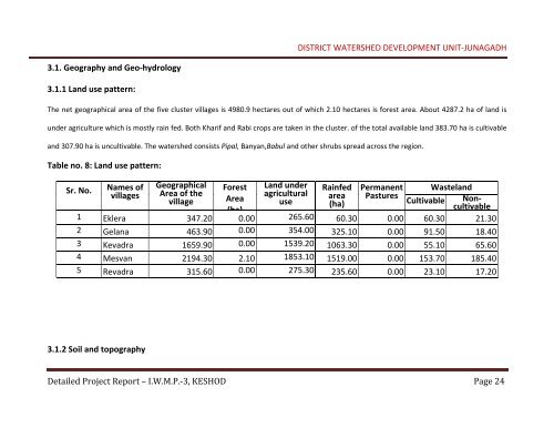
DISTRICT WATERSHED DEVELOPMENT UNIT‐JUNAGADH<br />
3.1. Geography and Geo‐hydrology<br />
3.1.1 Land use pattern:<br />
The net geographical area <strong>of</strong> the five cluster villages is 4980.9 hectares out <strong>of</strong> which 2.10 hectares is forest area. About 4287.2 ha <strong>of</strong> land is<br />
under agriculture which is mostly rain fed. Both Kharif and Rabi crops are taken in the cluster. <strong>of</strong> the total available land 383.70 ha is cultivable<br />
and 307.90 ha is uncultivable. The watershed consists Pipal, Banyan,Babul and other shrubs spread across the region.<br />
Table no. 8: Land use pattern:<br />
Sr. No. Names <strong>of</strong> Geographical Forest Land under Rainfed Permanent Wasteland<br />
villages Area <strong>of</strong> the<br />
agricultural<br />
village Area<br />
area Pastures<br />
use (ha)<br />
Cultivable Noncultivable<br />
(ha)<br />
1 Eklera 347.20 0.00 265.60 60.30 0.00 60.30 21.30<br />
2 Gelana 463.90 0.00 354.00 325.10 0.00 91.50 18.40<br />
3 Kevadra 1659.90 0.00 1539.20 1063.30 0.00 55.10 65.60<br />
4 Mesvan 2194.30 2.10 1853.10 1519.00 0.00 153.70 185.40<br />
5 Revadra 315.60 0.00 275.30 235.60 0.00 23.10 17.20<br />
3.1.2 Soil and topography<br />
Detailed Project Report – I.W.M.P.‐3, <strong>KESHOD</strong> Page 24


