

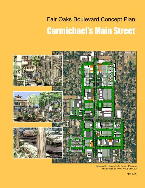
Carmichael's Main Street - sacog
Carmichael's Main Street - sacog
Carmichael's Main Street - sacog

You also want an ePaper? Increase the reach of your titles
YUMPU automatically turns print PDFs into web optimized ePapers that Google loves.
Fair Oaks Boulevard Concept Plan<br />
Carmichael’s <strong>Main</strong> <strong>Street</strong><br />
prepared by: Sacramento County Planning<br />
with assistance from: RACESTUDIO<br />
April 2006
Executive Summary<br />
The Concept Plan process has provided an opportunity for<br />
Carmichael residents, property owners and County departments<br />
to participate in creating a design concept for Fair Oaks<br />
Boulevard. The Concept Plan illustrates Draft General Plan and<br />
Carmichael Community Plan draft policies, addresses the creation<br />
of a special planning area (SPA), and compares roadway<br />
design options. Specifically, the concept plan illustrates ways in<br />
which the community’s desires for Fair Oaks Boulevard can be<br />
meshed with the roadway project proposed by the County of<br />
Sacramento.<br />
Fair Oaks Boulevard winds through well established and mature unincorporated<br />
neighborhoods in Sacramento County, which are surrounded by the region’s fast<br />
growing cities. The community envisions the transformation of the District into a<br />
pedestrian-friendly mixed-use place. There is an opportunity to demonstrate how<br />
community and General Plan policies can be implemented on Fair Oaks Boulevard.<br />
Above:<br />
The planning Focus Group<br />
expressed the desire to create<br />
a street that reestablished Fair<br />
Oak Boulevard’s social and<br />
economic status for the<br />
Carmichael community.<br />
Below:<br />
View of concept plan from the<br />
west<br />
The planning concepts for the Old Colony <strong>Main</strong> <strong>Street</strong> District envision a “big beautiful<br />
boulevard” where land uses cluster around open spaces, common areas and<br />
streets to create a sense of place. Parking lots and storefronts are to be connected<br />
with shared driveways and sidewalks. New land uses will provide improved commercial<br />
services for the community.<br />
Implementation of the Fair Oaks Boulevard Concept Plan will require a long-term<br />
commitment by the County, property owners and community. Overcoming the challenges<br />
inherent in revitalizing aging strip commercial corridors demand a comprehensive<br />
approach to updating regulations, committing necessary staff time, private<br />
sector leadership, and strategic public investment.<br />
page i
Fair Oaks Boulevard Concept Plan<br />
Left:<br />
This sketch shows the scale<br />
and quality of commons<br />
spaces envisioned for ownership<br />
townhouses located<br />
between Fair Oak Boulevard’s<br />
commercial uses and adjacent<br />
residential neighborhoods.<br />
Townhouses would be<br />
designed to transition in scale<br />
to the neighborhoods.<br />
Below:<br />
The Focus Group wanted to<br />
introduce open spaces that<br />
could provide a sense of place<br />
and a destination for the community.<br />
This sketch shows a<br />
new grocery store and “Old<br />
Colony Green” along the<br />
Boulevard.<br />
page ii
Right:<br />
The Focus Group imagined a<br />
future where Fair Oaks is a<br />
comfortable and safe walking<br />
environment. This sketch<br />
shows a planting strip with<br />
shade trees along the street.<br />
Storefronts facing the sidewalk.<br />
Below:<br />
The roadway improvements<br />
planned for Fair Oaks<br />
Boulevard will displace parking<br />
spaces from some of the<br />
area’s parcels. This sketch<br />
shows how the roadway project<br />
could connect sites together<br />
with shared parking access<br />
and pedestrian pathways.<br />
page iii
Recommended Organizational Actions:<br />
• Roadway Project Implementation–Form an implementation team comprised of<br />
County staff, citizens and property owners to provide feedback on the implementation<br />
and roadway design.<br />
• Colony <strong>Main</strong> <strong>Street</strong> Organization–Have County Economic Development staff work<br />
with the Carmichael Chamber of Commerce, citizens, and property owners to<br />
organize property owners into a promotional and advocacy group.<br />
Recommended Regulatory Actions:<br />
• Special Planning District–Prepare the necessary documentation and environmental<br />
review to create the Carmichael Colony <strong>Main</strong> <strong>Street</strong> SPA. Include recommendations<br />
for parking, land uses and development standards.<br />
• Design Guidelines Application–Apply the Community Design Guidelines to the<br />
roadway design and use the Fair Oaks Boulevard Concept Plan as the urban<br />
design concept that the guidelines support.<br />
Recommended Administrative Actions:<br />
• Staff Commitment–The County should allocate the resources to make sure planning,<br />
economic development and transportation staffing is adequate for planning<br />
and implementing the Concept Plan.<br />
Above and Below:<br />
These model images show<br />
how the Concept Plan anticipates<br />
blending residential and<br />
commercial uses into connected<br />
and pedestrian friendly<br />
places.<br />
page iv
Table of Contents<br />
Introduction<br />
Purpose<br />
Process<br />
Relationship to other Documents and Policies<br />
Organization of Report<br />
SECTION ONE: Community Context<br />
Fair Oaks Boulevard History<br />
Community Context<br />
Roadway Project<br />
SECTION TWO: Planning Concepts<br />
Planning Objectives<br />
Planning Policies/Principles<br />
Framework Plan Concepts<br />
Roadway Design Options<br />
SECTION THREE: Action Plan<br />
Implementation Opportunities<br />
Regulatory Actions<br />
Administrative Actions<br />
Acknowledgements<br />
Appendix (under separate cover)<br />
Workshop Summaries<br />
Slideshows
Introduction<br />
The Concept Plan process has provided an opportunity for<br />
Carmichael residents, property owners and County departments<br />
to participate in creating a design concept for Fair Oaks<br />
Boulevard. The Concept Plan illustrates Draft General Plan and<br />
Carmichael Community Plan draft policies, informs the creation<br />
of a special planning are (SPA), and compares roadway design<br />
options.<br />
Below:<br />
The Fair Oaks Boulevard<br />
Concept Plan is part of the<br />
community planning process<br />
involving the Carmichael community.<br />
It is to implement larger<br />
objectives from the Community<br />
Plan and inform the roadway<br />
planning and creation of development<br />
standards.<br />
Purpose<br />
The planning for the properties along Fair Oaks Boulevard was pursued as an outgrowth<br />
of the Carmichael Community Plan process. The Carmichael planning envisioned<br />
the properties along Fair Oaks Boulevard being transformed into the community’s<br />
main street district tasking the boulevard planning to identify desired land uses<br />
and design concepts that supported the Community Plan’s objectives. In addition to<br />
the Community Plan, the Fairs Oaks Boulevard planning has provided an opportunity<br />
to demonstrate draft General Plan policies and test the design implications of<br />
roadway options being prepared by Sacramento County Department of<br />
Transportation. The planning was scoped to provide a qualitative level of analysis<br />
and planning to support decision-making.<br />
page I-1
Fair Oaks Boulevard Concept Plan<br />
Process<br />
The Carmichael planning process is a multi-year effort to comprehensively update<br />
the Community Plan. The Fair Oaks Boulevard planning is a separate effort that falls<br />
under the umbrella of the community planning. A stakeholders group including residents<br />
and property owners met three times to establish objectives, identify potential<br />
concepts and review preliminary plans for Fair Oaks Boulevard. The process included<br />
two study sessions with the Board of Supervisors to review preliminary concepts<br />
and the draft planning recommendations.<br />
Organization of Report<br />
This report is organized as three sections with an introduction and appendix. Section<br />
one summarizes the area’s planning and policy context. The second section summarizes<br />
planning objectives, principles and concepts. The third section includes regulatory<br />
and administrative actions necessary to implement the plan. Workshop summaries<br />
and slide shows can be found in the appendix.<br />
Left:<br />
The April 4, 2004 Focus Group<br />
meeting provided an opportunity<br />
for stakeholders to:<br />
Review planning process<br />
Discuss public participation<br />
Identify planning objectives<br />
Left:<br />
The May 24, 2004 Focus<br />
Group meeting included a<br />
hands-on planning exercise<br />
where participants used the<br />
planning objectives developed<br />
at the first workshop to create<br />
concepts for Fair Oaks<br />
Boulevard.<br />
Left:<br />
The October 5, 2004 workshop<br />
provided a chance for stakeholders<br />
to discuss overall concepts<br />
and implementation<br />
issues.<br />
page I-2
SECTION ONE: Context<br />
Fair Oaks Boulevard is located in the middle of a growing region.<br />
The community envisions the transformation of the District into a<br />
pedestrian-friendly mixed-use place. There is an opportunity to<br />
demonstrate how the community’s and general plan policies can<br />
be implemented on Fair Oaks Boulevard.<br />
Section 1 of the Fair Oaks<br />
Boulevard Concept Plan<br />
includes:<br />
• History–brief history of<br />
Carmichael and Fair<br />
Oaks Boulevard;<br />
• Community<br />
Context–overview of<br />
regional and local position<br />
and conditions;<br />
• Roadway Project–summary<br />
of existing traffic<br />
conditions and alternative<br />
modes of travel; and<br />
• Policy Context–overview<br />
of key community and<br />
countywide policies.<br />
Below: Historic Carmichael<br />
Colony photos<br />
Fair Oaks Boulevard History<br />
Mr. Daniel W. Carmichael developed the Carmichael Colony in 1909. He purchased<br />
2,000 acres of land north and west of the American River. This land was part of the<br />
San Juan Grant of 1844. Two years later he acquired an additional 1,000 acres,<br />
which was part of Rancho Del Paso. Fair Oaks Boulevard runs between these two<br />
portions of land and was the primary road leading to J <strong>Street</strong> in downtown<br />
Sacramento.<br />
The following history of land uses along Fair Oaks Boulevard is from the Carmichael<br />
Chamber of Commerce website:<br />
Prior to 1940, the community had no central business district. The Red & White<br />
Store supplied meat and groceries at the corner of California and Fair Oaks<br />
Boulevard and there was a gas station at the triangle a Fair Oaks Boulevard and<br />
Manzanita Avenue. Another grocery store, Arrowhead, was on the southeast corner<br />
at Fair Oaks Boulevard and Palm Avenue and Dan Donovan operated a bar,<br />
restaurant and grocery store at Fair Oaks and Garfield.<br />
As Carmichael grew, businesses clustered around Palm Avenue and Marconi<br />
Avenue. Bob Marchal built the Carmichael Shopping Center on the southwest corner.<br />
One business, the Rose Tree remains in Carmichael today.<br />
<strong>Carmichael's</strong> first bank, The Suburban Bank, opened In the 1940's after Marchal<br />
drove to Washington, D.C. to obtain a bank charter. Crocker Bank took over the<br />
service in the 1950's.<br />
<strong>Carmichael's</strong> first large shopping complex was Crestview Center. It was built in<br />
1963 by Richard and Dea Holesapple.<br />
Since the 1950’s, Carmichael’s rural pattern of 10-acre orchards has evolved into<br />
suburban tract housing with apartments and commercial uses located along major<br />
streets. Fair Oaks Boulevard is the traditional central spine of the community that<br />
contained commercial services, churches, post office and the community park.<br />
As Carmichael and the region expanded, Fair Oaks Boulevard has witnessed the<br />
conversion of residential and traditional commercial development into auto-oriented<br />
uses. Largely due to the lack of land provided for other service commercial and<br />
industrial uses in the community and laze-faire zoning practices, Carmichael “main<br />
street” also has become a location for rent-sensitive uses such as mini-storage, thrift<br />
stores, industrial and auto repair businesses.<br />
Community Context<br />
The land use and transportation solutions for Fair Oaks Boulevard should be examined<br />
in the context of regional and local trends. This includes the position of Fair<br />
page 1-1
Fair Oaks Boulevard Concept Plan<br />
Left:<br />
The romantic rural Carmichael<br />
Colony was transformed after<br />
WWII into a prosperous suburban<br />
community. Fair Oaks<br />
Boulevard developed incrementally<br />
reflecting retailing and<br />
architectural of the times.<br />
This photo is of the Marconi,<br />
Fair Oaks and Palm Drive<br />
intersection. Some of the buildings<br />
and the palm trees still<br />
exist.<br />
Oaks Boulevard and the community of Carmichael in the region, how the planning<br />
area is defined and approached, what parts of the area are expected to change in<br />
the near and mid-term, and what existing uses support community life.<br />
Regional Position<br />
Over the past 30 years, Carmichael has evolved from a rural colony on the periphery<br />
of the Sacramento Metropolitan Area to a nearly built-out semi-rural and suburban<br />
community of approximately 72,000 people in the center of the expanding<br />
Sacramento Metropolitan Area. Carmichael and Fair Oaks Boulevard are surrounded<br />
by existing employment centers in Roseville and Sacramento and emerging development<br />
areas at former McClellan and Mather AFB’s. Other nearby major shopping<br />
centers and corridors include Auburn, Sunrise, Greenback, Galleria, and Madison<br />
(parts of which are within the Carmichael Community). The stretches of I-80 and<br />
Highway 50 north and south of Carmichael are the most heavily traveled commuter<br />
corridors in the region. Residents of Carmichael can only access these corridors by<br />
traveling through adjacent communities.<br />
Population in the six-county Sacramento Metropolitan Area is expected to grow by<br />
almost a million people, an increase of about 50 percent, between 2000 and 2025.<br />
Sacramento County is expected to have a more modest gain of approximately<br />
475,000 (a 39 % increase). By 2025, employment is expected to increase by about<br />
half a million (a 60% increase). This job growth is expected primarily in downtown<br />
Sacramento, South Placer County (Roseville and Rocklin), and the U.S. 50 Corridor<br />
(West Sacramento, Rancho Cordova, and Folsom/West El Dorado County), which<br />
all lie within a 20-mile radius of Fair Oaks Boulevard.<br />
Planning Boundary and Sub-Districts<br />
The Fair Oaks Boulevard planning area encompasses commercial and contiguous<br />
residential parcels located between Oak Avenue and Manzanita Avenue. Fair Oaks<br />
Boulevard runs between the original 2,000 and 1,000-acre rural “colonies” created<br />
by Daniel W. Carmichael in 1909. Approximately 2 miles long, the planning area has<br />
three sub-districts:<br />
Above:<br />
Some of the original<br />
Carmichael Colony structures<br />
can be found in the planning<br />
area. These smaller buildings<br />
have been home to several<br />
generations of local businesses.<br />
Many have been<br />
“improved” over the years<br />
obscuring original design features<br />
and details.<br />
Manzanita Sub-District<br />
The Manzanita District is the northern portion of the Boulevard. Predominate ecopage<br />
1-2
Regional Context<br />
Above:<br />
Regional Congestion<br />
Regional Growth<br />
Carmichael and Fair Oaks<br />
Boulevard are becoming<br />
increasingly central to the<br />
regions population and job<br />
growth.<br />
Source: SACOG<br />
Right:<br />
Fair Oaks Boulevard runs<br />
between growing areas along<br />
Highway 50 and I-80. This map<br />
from SACOG shows the major<br />
roads that are currently congested<br />
and projected congested<br />
areas in 2025. From a<br />
regional perspective, Fair Oaks<br />
Boulevard has not been identified<br />
as a congested corridor<br />
within the Carmichael community<br />
planning area.<br />
page 1-3
Fair Oaks Boulevard Concept Plan<br />
nomic activities include larger commercial centers, mix of small commercial service<br />
uses, industrial and automotive uses. This area includes completed roadway and<br />
sidewalk enhancements.<br />
Colony <strong>Main</strong> <strong>Street</strong> Sub-District<br />
The Colony <strong>Main</strong> <strong>Street</strong> District is located between Engle Avenue north of<br />
Carmichael Park and Kenneth Avenue south of Marconi Avenue. It includes<br />
Carmichael Park, the Carmichael Post Office, multi-family residential, a mix of commercial<br />
services, industrial, self-storage and vacant parcels. This area is contiguous<br />
with the next phase of roadway improvements.<br />
Community Plan Context<br />
Left:<br />
the 1993 Carmichael<br />
Community Plan Map shows<br />
Fair Oaks Boulevard as the primary<br />
commercial and community<br />
address. Other important<br />
commercial corridors that intersect<br />
with Fair Oaks Boulevard<br />
include Marconi, Manzanita<br />
and El Camino.<br />
Manzanita<br />
Below:<br />
Auto repair and related business<br />
are common on Fair<br />
Oaks Boulevard.<br />
Fair Oaks Blvd.<br />
Marconi<br />
F a i r O a k s B o u l e v a r d<br />
El Camino<br />
page 1-4
South Gateway Sub-District<br />
The South Gateway Sub-District is located between Kenneth Avenue and Oak<br />
Avenue. It is comprised of a mix of shallow lot commercial and apartment uses.<br />
Development Suitability<br />
The planning assumes the private market will determine which sites are developed<br />
but anticipates reinvestment opportunities. There are 14 vacant parcels in the area.<br />
There are 20 parcels that are being used for industrial and mini-storage uses. There<br />
are seven larger shopping centers and discount stores of various ages comprised of<br />
17 parcels. Automotive service and repair uses occupy 32 parcels. Overtime, these<br />
Right:<br />
The 2 mile long planning area<br />
has three distinctive character<br />
areas or sub-districts. These<br />
have played different economic<br />
roles. As a result, they have a<br />
different mix of uses and visual<br />
character.<br />
Below:<br />
The commercial uses and<br />
buildings vary in age.<br />
Generally, older buildings orient<br />
towards the streets and<br />
newer buildings towards parking<br />
lots.<br />
Sub-Districts<br />
Manzanita District<br />
• Large commercial centers<br />
• Mix of small, shallow commercial lots<br />
• Cluster of industrial and automotive uses<br />
Extent of roadway<br />
improvements<br />
Nice tree canopy along<br />
residential and park<br />
edge<br />
Colony <strong>Main</strong> <strong>Street</strong> District<br />
• Mixed commercial district<br />
• Community facilities and park<br />
• Vacant parcels and underutilized buildings<br />
Remaining “Old Colony”<br />
commercial structures<br />
Marconi Gateway and<br />
historic Palm Drive<br />
South Gateway District<br />
• Mixed commercial and apartment district<br />
• Small, shallow commercial lots<br />
Apartments frame entry<br />
to district<br />
page 1-5
Fair Oaks Boulevard Concept Plan<br />
large, vacant and underutilized parcels are the most susceptible to change in use or<br />
be redeveloped with new buildings.<br />
Community Elements<br />
In the planning area are uses that support adjacent neighborhoods and provide a<br />
focus for community life. These include housing of various types, public uses such<br />
as the park and school in the Manzanita Sub-District, churches and grocery stores.<br />
Roadway Project<br />
The County is planning to improve Fair Oaks Boulevard between Marconi Avenue<br />
Manzanita District<br />
Area A: Automotive and<br />
Industrial Cluster<br />
Opportunities:<br />
• Potential for small scale commercial<br />
uses with shared parking access and<br />
connected storefronts<br />
• Residential on larger industrial sites<br />
Area B/C: Community Shopping<br />
Centers<br />
Opportunities:<br />
• Potential future redevelopment of shopping<br />
centers for mixed-use projects<br />
• Residential on larger industrial sites<br />
Colony <strong>Main</strong> <strong>Street</strong><br />
District<br />
Area D: Vacant Sites and<br />
Automotive Uses<br />
Opportunity Sites<br />
B<br />
sc<br />
v<br />
sc<br />
v<br />
v<br />
a<br />
a<br />
sc<br />
a<br />
a<br />
a<br />
sc<br />
v<br />
a i<br />
a<br />
v<br />
a<br />
sc<br />
a<br />
a<br />
i<br />
C<br />
i<br />
D<br />
A<br />
i<br />
a a<br />
aa a a<br />
a<br />
i<br />
i<br />
Left:<br />
Over the next 25 years most of<br />
Fair Oaks Boulevard’s uses<br />
and structures will undergo a<br />
change in use or be redeveloped.<br />
Certain parts of the planning<br />
area are most susceptible<br />
to change than others due to<br />
the large size of the parcel,<br />
marginal value of existing<br />
uses, or they are vacant.<br />
Below:<br />
The planning has anticipated<br />
where opportunity sites are<br />
clustered. These photos are of<br />
vacant parcels.<br />
Opportunities:<br />
• Potential for small scale commercial<br />
uses with shared parking access and<br />
connected storefronts<br />
Area E: Older Commercial<br />
Centers and Vacant Sites<br />
Opportunities:<br />
• Potential future redevelopment of shopping<br />
centers and vacant parcels for<br />
mixed-use projects<br />
• Residential on larger industrial sites<br />
South Gateway District<br />
i<br />
i<br />
sc<br />
a<br />
a<br />
v<br />
sc<br />
v<br />
v<br />
a<br />
sc<br />
v<br />
sc<br />
v<br />
E<br />
Key<br />
v Vacant Sites<br />
i Industrial and Mini-Storage<br />
sc Shopping Center or Discount Store<br />
a Auto Service<br />
(Mini-lube, car wash, auto sales,<br />
gas station, auto repair)<br />
Area F: Automotive Intersection<br />
a<br />
a<br />
F<br />
Opportunities:<br />
• Potential for small scale commercial<br />
uses with shared parking access and<br />
connected storefronts<br />
page 1-6
and Engle Avenue. This section of roadway has several unsignalized intersections,<br />
many driveway curb cuts, a lack of continuity in the sidewalk system and difficult left<br />
turn access. There have been several options prepared with various types of pedestrian<br />
and lane width improvements that are analyzed in Section Three.<br />
In 2004, the County’s traffic consultant prepared a report summarizing existing conditions<br />
and analyzing various roadway design alternatives. Findings regarding existing<br />
traffic conditions included:<br />
• Fair Oaks Boulevard is an urban arterial street classified as a “Thoroughfare” in<br />
the current General Plan (a six-lane limited access street).<br />
Right:<br />
Community Elements<br />
Fair Oaks Boulevard has traditionally<br />
served the Carmichael<br />
community. In the planning<br />
area are uses that contribute to<br />
the sense of community. These<br />
include residential uses, grocery<br />
stores, churches,<br />
Carmichael Park, the post<br />
office and a school. These<br />
uses can be integrated into the<br />
planning to enhance the<br />
Boulevards role as the community’s<br />
“main street”.<br />
Manzanita District<br />
School Site<br />
Grocery Stores<br />
Commercial Services<br />
Residential<br />
g<br />
r<br />
r<br />
r<br />
r<br />
r<br />
r<br />
r<br />
g<br />
r<br />
r<br />
r<br />
c<br />
r<br />
School<br />
r<br />
p<br />
Below:<br />
Photos of Carmichael Park and<br />
post office<br />
Colony <strong>Main</strong> <strong>Street</strong> District<br />
Park<br />
PO<br />
r<br />
Community Park<br />
Residential<br />
Churches<br />
Commercial Services<br />
r<br />
r<br />
r<br />
c<br />
c<br />
Key<br />
r<br />
Housing<br />
r<br />
p<br />
Public Use<br />
r<br />
c<br />
g<br />
Church<br />
Grocery Store<br />
South Gateway District<br />
Residential<br />
r<br />
r<br />
r<br />
r<br />
r<br />
page 1-7
Fair Oaks Boulevard Concept Plan<br />
• Fair Oaks Boulevard carries about 56,500 cars per day through the Manzanita<br />
Avenue to Engle Avenue segment and 42,600 in the Marconi Avenue to El<br />
Camino Avenue segment.<br />
• The existing roadway level of service (LOS) between Manzanita Avenue and El<br />
Camino Avenue is F in the AM and PM.<br />
• The worst performing intersections are the unsignalized ones at Landis Avenue (F<br />
in AM and PM), North Avenue (LOS C in AM and F in PM), and Robertson Avenue<br />
(LOS D in AM and C in PM).<br />
Alternative Mode Travel<br />
One of the issues discussed in the County’s traffic study, and by participants in the<br />
Roadway Improvements<br />
Manzanita District<br />
Area of previous improvements<br />
• Widened to six lanes<br />
• Roadway resurfacing<br />
• Curb-gutter sidewalk<br />
• Brick pavers in curb cuts<br />
Colony <strong>Main</strong> <strong>Street</strong> District<br />
Left:<br />
As part of an ongoing roadway<br />
program, Sacramento County<br />
Department of Transportation<br />
prepared improvement alternatives.<br />
The diagram on the left<br />
shows the scope of the initial<br />
phase completed in 2003 and<br />
the next phase to be completed<br />
in 2008.<br />
Below:<br />
The northern portion of the<br />
planning area had modest<br />
roadway improvements including<br />
widening to six lanes,<br />
resurfacing and new curb-gutter-sidewalk.<br />
• Extent of new roadway improvement<br />
plan<br />
• Potential to support economic<br />
development and image enhancement<br />
of Carmichael <strong>Main</strong> <strong>Street</strong><br />
South Gateway District<br />
• Improvements to Oak Avenue/Fair<br />
Oaks Boulevard are planned to<br />
permanently eliminate left turns<br />
from Oak Avenue on to Fair Oaks<br />
Boulevard<br />
page 1-8
workshops, was the lack of safe choices to driving on the Boulevard. The traffic<br />
study identified the following issues:<br />
• Poor continuity in sidewalks and crosswalks;<br />
• Lack of ADA/disabled access accommodations;<br />
• Lack of landscaping;<br />
• Poor separation and definition between pedestrian routes and auto traffic; and<br />
• No bikes lanes.<br />
Below:<br />
Fair Oaks Boulevard is an<br />
important transit corridor with<br />
ample opportunity to add uses<br />
that can provide economic<br />
energy while improving neighborhoods.<br />
The 2004 Corridor<br />
Conditions and Opportunities<br />
Study prepared by the County<br />
identified over 3 million square<br />
feet of existing space in the<br />
Central Fair Oaks Boulevard<br />
area, of which the planning<br />
area is part of. Assuming existing<br />
zoning, the study concluded<br />
that over 900,000 square<br />
feet of new development<br />
capacity existed on underutilized<br />
sites.<br />
The road has very low pedestrian and bike usage as a result of unfriendly walking<br />
and biking conditions, land use mix, and site planning. The traffic study stated the<br />
total peak hour bike and pedestrian movements was only 54 (46 pedestrians and<br />
eight bikes).<br />
Fair Oaks Boulevard and Manzanita Avenue are feeder routes for RT buses. There<br />
are four transit routes that use portions of Fair Oaks Boulevard and one that travels<br />
east of Manzanita Avenue.<br />
Policy Context<br />
Fair Oaks Boulevard planning is an outgrowth of the Carmichael Community Plan<br />
and concurrent with a major update of Sacramento County’s General Plan. The<br />
planning for the Fair Oaks Boulevard area should reflect local objectives in the context<br />
of larger public objectives, goals and policies.<br />
Carmichael Community Plan Policies<br />
The following policies are from the Carmichael Community Plan and are relevant to<br />
the planning for Fair Oaks Boulevard:<br />
• Designate a portion of Fair Oaks Boulevard Corridor as a <strong>Main</strong> <strong>Street</strong> with a common<br />
design theme (architectural design standards, landscaping, signage, street<br />
lights).<br />
• <strong>Main</strong>tain/Improve traffic flow (and control speeding) in Carmichael.<br />
• Efforts by the County to improve Fair Oaks Boulevard shall be coordinated with<br />
the Special Planning Area ordinance process. It shall be recognized that the plan<br />
to create a "<strong>Main</strong> <strong>Street</strong>" needs to consider that FOB will remain a major corridor<br />
for auto traffic that should not be shifted to the neighborhood streets surrounding<br />
Fair Oaks Boulevard. Because Fair Oaks Boulevard will remain a transportation<br />
corridor, alternative modes of transportation shall be encouraged.<br />
• Projects within residentially zoned high density and commercially zoned areas<br />
along the major streets should be developed as mixed-use (retail and high density<br />
residential in the same development) which are compatible with adjacent residential<br />
neighborhoods and promotes public transit.<br />
• Increase the level of public transit service to Carmichael.<br />
• Create a network of bike lanes throughout Carmichael connecting parks, schools,<br />
the library, shopping, and neighborhoods.<br />
• Accelerate the pace of pedestrian-friendly improvements.<br />
• An effort should be made to actively recruit businesses that will enhance<br />
Carmichael such as restaurants, boutiques, and businesses that are oriented to<br />
families.<br />
Current Sacramento County General Plan Policies<br />
The following policies are from our Existing General Plan – December 15, 1993.<br />
The General Plan is currently being updated with a greater emphasis on community<br />
design and reliance on community and corridor plans to provide more detailed guid-<br />
page 1-9
Fair Oaks Boulevard Concept Plan<br />
ance.<br />
Land Use:<br />
• Provide for additional mixed use development in commercial parking areas near<br />
the trunk of feeder line networks where such uses would be compatible with surrounding<br />
uses and where parking demand can be appropriately accommodated or<br />
structured parking can be constructed. (LU-6)<br />
• Discourage the establishment and build-out of linear, strip pattern, commercial<br />
centers (LU-33)<br />
• Discourage the creation of excessive amounts of retail shopping facilities.(LU-34)<br />
Circulation:<br />
• Funding for development, operations, and maintenance of facilities for mass transit,<br />
bicycle, and pedestrian modes of transportation shall be given appropriate priority<br />
for transportation programs. (C1-5)<br />
• Encourage transit, bicycle, and pedestrian projects when making decisions for the<br />
expenditure of discretionary local, state, or federal funds and in the Sacramento<br />
County Capital Improvement Program and the Congestion Management Plan.<br />
(C1-6)<br />
• Sacramento County shall reduce automobile travel demand by promoting mixed<br />
use development throughout the county, including the development of neighborhood<br />
support commercial services in areas that are primarily residential. (C1-11)<br />
• Sacramento County shall utilize design and development standards which support<br />
travel by transit, walking, bicycling, and clean alternative fuel and low emission<br />
vehicles. (C1-14)<br />
Emerging General Planning Themes<br />
Sacramento County’s General Plan was in the process of being updated during the<br />
Fair Oaks Boulevard planning effort and the Commercial Corridor Study. Many of the<br />
opportunities and emerging themes from these efforts are demonstrated by the Fair<br />
Oaks Boulevard Concept Plan.<br />
Three opportunities and themes identified in the General Plan update process<br />
include:<br />
• Viewing commercial corridors in the context of community plan objectives;<br />
• Revitalizing the county’s underutilized commercial corridors as mixed-use streets<br />
that serve both regional commercial and local service needs; and<br />
• Making commercial corridors mixed-mode streets with an emphasis on uses and<br />
site planning that facilitate the use of transit.<br />
Draft Community Design Guidelines<br />
The Draft Community Design Guidelines provide guidance for the quality of site<br />
planning, architecture and signage. The Guidelines apply to both new development<br />
and renovation of existing sites and buildings.<br />
The Guidelines identify the following three design opportunities for mixed-use<br />
streets:<br />
• Integrate residential and commercial uses with renovated or new development as<br />
an economic development catalyst;<br />
• Creating better pedestrian connection between neighborhoods and commercial<br />
corridors; and<br />
• Creating transit and pedestrian-friendly options to isolated apartments.<br />
Above:<br />
Sacramento County has prepared<br />
a study of commercial corridors<br />
that identifies opportunities and is<br />
preparing Community Design<br />
Guidelines that will provide qualitative<br />
direction for new investment<br />
in commercial, business and<br />
mixed-use districts.<br />
page 1-10
SECTION TWO: Planning Concepts<br />
The planning concepts for the Old Colony <strong>Main</strong> <strong>Street</strong> District<br />
envision a “big beautiful boulevard” where land uses cluster<br />
around open spaces, common areas and streets to create a<br />
sense of place. Parking lots and storefronts are connected with<br />
shared driveways and sidewalks. And, new land uses provide<br />
improved commercial services for the community.<br />
Section 2 of the Fair Oaks<br />
Boulevard Concept Plan<br />
provides a summary of:<br />
• Objectives–that express<br />
intended to express<br />
expectations for the<br />
Boulevard;<br />
• Principles–which communicate<br />
directives for public<br />
and private investment;<br />
and<br />
• Concepts– that provide a<br />
framework of land use,<br />
circulation and design<br />
ideas that express the<br />
objectives and principles.<br />
Community Objectives<br />
In community workshops, participants identified leading objectives for land use, circulation<br />
and design. The objectives are intended to describe expectations. The community<br />
members that participated in the planning process expressed the desire for<br />
higher quality commercial uses that supported a walkable environment and created<br />
a sense of place.<br />
Land Use Objectives<br />
Land use objectives focus on increasing the quality of businesses and enhancing the<br />
image of Fair Oaks Boulevard as a commercial and neighborhood address.<br />
Objective 1: High Quality Commercial Uses<br />
Encourage the retention and recruitment of commercial businesses that are high<br />
quality. Cycle-out less desirable businesses such as auto repair, thrift stores and<br />
massage parlors.<br />
Objective 2: Pedestrian and Neighborhood Friendly Businesses<br />
Support businesses that result in a more pleasing pedestrian experience and<br />
social interaction that reinforce the sense of community such as cultural activities.<br />
Objective 3: Mix of Uses<br />
Include a variety of uses in the district including family-friendly commercial services,<br />
restaurants and housing.<br />
Circulation Objectives<br />
Overall circulation objectives reflect the desire for a street and district that works for<br />
all modes of travel and access.<br />
Objective 1: Pedestrian Friendly<br />
Improve the level of pedestrian comfort and interest along the street and between<br />
individual parcels parallel to Fair Oaks Boulevard and meet ADA standards.<br />
Objective 2: Traffic Flow<br />
<strong>Main</strong>tain or improve roadway capacity while slowing down traffic to make conditions<br />
safer and more comfortable for pedestrians and bicycles.<br />
Objective 3: Major Transportation Corridor(added by County staff)<br />
Recognize that Fair Oaks Boulevard will remain as a major transportation corridor<br />
so as to not shift traffic onto adjacent neighborhoods.<br />
Objective 4: Transit<br />
Provide public transportation to Fair Oaks Boulevard that gets you there directly<br />
and cheaply.<br />
Objective 5: Neighborhood Linkages<br />
Improve walking and bicycle connections to adjacent neighborhoods and to the<br />
park.<br />
Objective 6: Regional Connections<br />
To Develop alternative transportation options between I-80 and Highway 50 that<br />
page 2-1
Fair Oaks Boulevard Concept Plan<br />
do not involve driving through this residential community– including ideas contained<br />
in mobility study (last part of objective added by County staff).<br />
Community Design Objectives<br />
Design objectives reflect the desire to have investment on Fair Oaks Boulevard reinforce<br />
the sense of community found in residential neighborhoods in Carmichael.<br />
Objective 1: Sense of Place<br />
Organize land uses and buildings to create a sense of place that brings people<br />
together. Ensure both public and private investment contributes to enhancing the<br />
unique character and history of Carmichael.<br />
Objective 2: Site and Landscape Design<br />
Create a landscape plan for the roadway and new private development that<br />
makes the district cool and comfortable for walking. Use street lighting, landscaping<br />
and district signage to highlight Carmichael’s uniqueness.<br />
Objective 3: Architectural Design<br />
Design commercial buildings to add interest at a pedestrian pace and become an<br />
integral part being part of a main street district.<br />
Objective 4: Signage<br />
Include signage for businesses and the district that reflect both the pedestrian and<br />
auto-oriented nature of Fair Oaks Boulevard.<br />
Planning Principles<br />
Principles communicate directives for public and private investment. They provide a<br />
set of basic rules for land use, circulation and design.<br />
Principle 1. Create a “Colony <strong>Main</strong> <strong>Street</strong> District” between Marconi Avenue and<br />
Carmichael Park that provides a social and economic focus for the community.<br />
The County should work with property owners and the community to create a contemporary<br />
Colony <strong>Main</strong> <strong>Street</strong> District on Fair Oaks Boulevard. The district should<br />
have an overall urban design concept that is coordinated with the design of the roadway<br />
projects and new private development.<br />
Principle 2. Make the <strong>Main</strong> <strong>Street</strong> a mixed-use place that includes commercial services,<br />
residential and community uses.<br />
Fair Oaks Boulevard should become a mixed-use district that includes housing.<br />
Housing should be located around the park, as part of small commercial developments,<br />
and when feasible, over commercial storefronts. Commercial uses such as<br />
grocery stores, restaurants, offices and shops should be encouraged to be located<br />
on Fair Oaks Boulevard.<br />
Principle 3. Cluster uses around open space to create a sense of place.<br />
New investment should create a sense of place. New buildings should be organized<br />
around open spaces, along walking routes and clustered to define and activate<br />
spaces. There should be a variety of architecture and walking experiences. Parking<br />
should be located behind or beside buildings.<br />
Principle 4. Interconnect new and existing uses to side streets and along Fair Oaks<br />
Boulevard with sidewalks and driveways.<br />
New streetscape and development should connect side streets to Fair Oaks<br />
Boulevard’s storefronts and places. Buildings along Fair Oaks Boulevard should face<br />
sidewalks and share parking.<br />
Vision of the Colony <strong>Main</strong><br />
<strong>Street</strong> District<br />
The Carmichael Community<br />
Plan envisions Fair Oaks<br />
Boulevard being transformed<br />
into a contemporary<br />
main street for the community’s<br />
72,000 people. This<br />
overall goal inspired the creation<br />
of the Fair Oaks<br />
Boulevard Concept Plan.<br />
Participants in workshops<br />
identified the design features<br />
and uses that characterized<br />
Fair Oaks Boulevard’s traditional<br />
design features and<br />
uses.<br />
Design Features of the “Old<br />
Colony” of Carmichael:<br />
• Setbacks were consistent<br />
between buildings creating<br />
a connected series of<br />
storefront buildings<br />
• The investment was<br />
fresh, better condition<br />
• There was variety in the<br />
architecture<br />
• There were covered walkways<br />
Uses of the “Old Colony”<br />
main street:<br />
• Grocery stores<br />
• Apparel shops<br />
• Gas and service stations<br />
• Sit-down restaurants<br />
• Other commercial services<br />
for a semi-rural and<br />
suburban community<br />
page 2-2
Principle 5. Make the Colony <strong>Main</strong> <strong>Street</strong> District a comfortable and interesting walking<br />
experience.<br />
The roadway project and new private investment should contribute to the successful<br />
evolution of Fair Oaks Boulevard into a mixed-mode district. <strong>Street</strong>scape, landscaping,<br />
pedestrian routes, building placement and design and open spaces should all<br />
make walking the preferred mode to traverse the district.<br />
Framework Plan Concepts<br />
The planning framework for the district addresses all three of Fair Oaks Boulevard’s<br />
sub-districts at a conceptual level and the Colony <strong>Main</strong> <strong>Street</strong> Sub-District in greater<br />
detail. Generally, the overall traditional role of the sub-districts is enhanced.<br />
Right:<br />
The diagram on the right represents<br />
an overall long-term conceptual<br />
framework for the Fair<br />
Oak Boulevard planning area.<br />
It identifies:<br />
• Land uses for sub -districts;<br />
• Clusters of opportunity sites<br />
that can become mixed-use<br />
developments around a<br />
regional transit stop; and<br />
• A general locations of common<br />
open spaces.<br />
Below:<br />
The concept assumes pedestrian<br />
friendly storefront commercial<br />
uses and ownership<br />
housing as an interface with<br />
existing neighborhoods.<br />
T<br />
T<br />
Planning Concept Framework<br />
Manzanita District<br />
• Community-serving commercial<br />
• Later phase mixed-use conversion of shopping<br />
centers<br />
Shopping center and<br />
industrial sites converted<br />
to mixed-use sites over<br />
time<br />
Extending the “park-like”<br />
qualities of the street<br />
edge<br />
Colony <strong>Main</strong> <strong>Street</strong> District<br />
• Mixed-use commercial and residential district<br />
• Community facilities and park<br />
• Mixed-use projects provide social and commercial<br />
focus<br />
• Open space framework<br />
Remaining “Old Colony”<br />
commercial structures<br />
used to establish street<br />
edge shopping<br />
T<br />
Key<br />
Housing<br />
Public Use<br />
Church<br />
Existing Grocery Store<br />
Mixed-use project<br />
Walking Edge<br />
Pedestrian Connection<br />
Open Space<br />
Marconi Gateway and<br />
historic Palm Drive<br />
storefront district<br />
South Gateway District<br />
• Mixed commercial and apartment district<br />
• Small, shallow commercial lots<br />
Apartments and small<br />
offices renovated over<br />
time<br />
page 2-3
Fair Oaks Boulevard Concept Plan<br />
Manzanita Avenue and Marconi Avenue will continue to be important community<br />
shopping focal points while other parts of the sub-district provide for adding residential<br />
and smaller clusters of commercial activities. Connected open space is envisioned<br />
as part of the overall concept in each sub-district.<br />
Manzanita Sub-District<br />
The Manzanita Sub-District concept assumes the transformation of the area’s industrial<br />
and automotive repair uses into commercial and residential. In the longer term,<br />
larger shopping centers could be redeveloped into mixed-use projects that include<br />
shopping for area residents. A major transit stop would be located at the Manzanita<br />
intersection.<br />
Below:<br />
The objectives for the Colony<br />
<strong>Main</strong> <strong>Street</strong> District identified<br />
by workshop participants<br />
emphasized uses and design<br />
that made the Boulevard a<br />
social and economic destination.<br />
New investment is to create<br />
a “sense of place”.<br />
Colony <strong>Main</strong> <strong>Street</strong> Sub-District<br />
The Colony Sub-District is to become the social and economic focus for the<br />
Carmichael community. This area will be initially improved by the implementation of<br />
the roadway project and related streetscaping. It will become a mixed-use commercial<br />
and residential area that features open space, pedestrian connectivity and<br />
Carmichael Park. Transit stops would be located at the park and Palm Drive/Marconi<br />
Avenue, including the southwest corner of Fair Oaks Boulevard and Marconi<br />
Avenue.<br />
South Gateway Sub-District<br />
The South Gateway Sub-District will continue to provide for small-scale commercial<br />
services, offices and apartments. The planning anticipates upgrading and replacing<br />
existing buildings as they reach the end of their economic life.<br />
Colony <strong>Main</strong> <strong>Street</strong> District Concepts<br />
The Colony <strong>Main</strong> <strong>Street</strong> Sub-District is to become the primary pedestrian-oriented<br />
central place for Carmichael. The area is over one mile in length and has two important<br />
focal points. One is the Palm Drive/Marconi Avenue intersection. This area has<br />
been the traditional location for commercial services and has remaining some of the<br />
pre-1950’s buildings that can be integrated into plans. The other is Carmichael Park.<br />
This area has multi-family housing, the post office and distinctive tree canopy. There<br />
are vacant sites and other redevelopment opportunity sites near the park. Other<br />
parts of the Colony <strong>Main</strong> <strong>Street</strong> Sub-District are expected to developed in smaller<br />
clusters of parcels around shared parking and open spaces.<br />
Mixed-use with Commercial Frontage<br />
The overall approach to land use and site planning in the Colony <strong>Main</strong> <strong>Street</strong> area is<br />
to provide a continuous commercial walking edge with residential uses located<br />
between commercial and existing neighborhoods. This approach provides the<br />
pedestrian friendly atmosphere desired by the community and buffer existing homes<br />
from commercial uses and parking lots. Mixed-use developments would be organized<br />
around shared parking and open spaces.<br />
Desired Land Uses<br />
Desired uses in the Colony <strong>Main</strong> <strong>Street</strong> area included sit-down (non-fast food)<br />
restaurants, coffee shops/cafes, professional offices, and grocery stores or specialty<br />
food markets. Less desirable uses include mini-storage facilities, industrial, thrift<br />
stores, massage and tanning salons, recycling centers, auto repair and service stations.<br />
These uses are not viewed as appropriate for Carmichael’s “main street” district<br />
and have a negative impact on investor interest.<br />
page 2-4
Below:<br />
Below is an illustrative plan for<br />
Colony <strong>Main</strong> <strong>Street</strong> District<br />
around Palm Drive. It shows<br />
how the existing driveway and<br />
parking lot system can become<br />
streets; assumes renovation of<br />
many of the existing commercial<br />
buildings and older shopping<br />
centers; adds townhouses<br />
adjacent to residential neighborhoods;<br />
and provides a system<br />
of common open spaces.<br />
Community Uses<br />
Fair Oaks Boulevard has been a traditional location for community serving institutional<br />
uses. The area has the park, library (on Marconi Avenue), post office, and<br />
churches. The community expressed a desire for future cultural uses, such as community<br />
theater, be located in the area.<br />
Big Beautiful Boulevard<br />
The design concept envisions the development of a “big beautiful boulevard”. Big<br />
trees and pedestrian amenities are ways to improve the image of Fair Oaks<br />
Boulevard and create and an environment that supports the types of places and<br />
economic investment desired for the Colony <strong>Main</strong> <strong>Street</strong> area. A comprehensive<br />
Colony <strong>Main</strong> <strong>Street</strong> Illustrative Plan<br />
Fair Oaks Boulevard<br />
Palm Drive<br />
page 2-5
Fair Oaks Boulevard Concept Plan<br />
streetscape design would make walking more comfortable and safe by consolidating<br />
curb cuts, introducing shade, and enhancing the overall identity of the district.<br />
Architectural Design<br />
The design of new buildings and renovation of existing ones are to provide architectural<br />
variety with continuity being created by each project’s efforts to orient towards<br />
the street and sidewalks. Commercial buildings should include storefronts, awning<br />
and canopies, pedestrian scaled signage and building massing broken up to reflect a<br />
walking pace and scale. Residential buildings should orient towards common spaces<br />
and streets and possess overall massing and roof forms that reflect the scale and<br />
traditions of nearby houses.<br />
Roadway Design<br />
The Fair Oaks Boulevard Concept Plan’s initial public investment will be the<br />
improvements to the roadway. The roadway planning and district planning efforts<br />
have produced alternatives that were reviewed by the Board of Supervisors. The<br />
Below:<br />
The photographs and sketch<br />
elevations below illustrate how<br />
new development can contribute<br />
to the Colony <strong>Main</strong><br />
<strong>Street</strong> District’s sense of place.<br />
The building designs reflect a a<br />
sensitivity to pedestrian scale<br />
and pace desired by the community.<br />
The commercial buildings<br />
have transparent storefronts<br />
and architectural features<br />
that add interest to the<br />
street. Townhouses and mixeduse<br />
buildings express individual<br />
units and have a variety of<br />
roof and architectural elements.<br />
Illustrative Architectural Concepts<br />
page 2-6
Supervisors selected four for further analysis. The County’s Department of<br />
Transportation has provided a technical review and descriptions of the alternatives to<br />
accommodate 56,000 daily car trips. The Fair Oaks Boulevard Concept Plan<br />
includes a qualitative comparison with a goal to improve traffic flow and safety,<br />
enhance walking environments, and improve the image of the street.<br />
Roadway Design Context: Designing for a Preferred Future<br />
The roadway design alternatives should be viewed both within the current environment<br />
and as part of a future main street for Carmichael. The scope and design of<br />
the roadway project should strive to enhance the pedestrian experience, improve<br />
access to transit, replace parking, and anticipate future parcel consolidation.<br />
Above:<br />
The community wants Fair<br />
Oaks to be a “big beautiful<br />
boulevard”.<br />
Above:<br />
Alternative 1: Existing Road (no project)<br />
Above:<br />
Alternative 2: Four-Lane Boulevard<br />
Above:<br />
Alternative 3: Six-Lane Road with Median<br />
Above:<br />
Alternative 4: Six-Lane Boulevard<br />
page 2-7
Fair Oaks Boulevard Concept Plan<br />
Current Context: Auto Oriented Commercial Strip<br />
• 80’ ROW without landscaping<br />
• Curb cuts for each individual site<br />
• Poor traffic flow<br />
• Poor pedestrian safety<br />
• Lack of traffic or pedestrian connections between parcels<br />
• Lack of connections to adjacent neighborhoods<br />
Left:<br />
This 3-D computer model<br />
shows the existing building<br />
pattern and scale near Palm<br />
Drive and Angeline Avenue.<br />
Below:<br />
Existing street edge conditions<br />
page 2-8
Future Context: MIxed-use and MIxed-mode <strong>Main</strong><br />
<strong>Street</strong> District<br />
• Wider ROW with landscaping<br />
• Shared parcel access<br />
• Improved traffic flow<br />
• Improved pedestrian safety and comfort<br />
• Improved access to transit<br />
• Auto and pedestrian connections between parcels<br />
Right:<br />
This 3-D computer model illustrates<br />
a future context for roadway<br />
improvements.<br />
Below:<br />
Desirable conditions for commercial<br />
and townhouse street<br />
edges<br />
page 2-9
view<br />
Fair Oaks Boulevard Concept Plan<br />
Alternative 1: No Build (Existing 80’ ROW)<br />
Above:<br />
The photo is of the area between Marconi and Robertson Avenue. The existing<br />
roadway lacks landscaping, has many individual curb cuts, and does not provide<br />
a comfortable walking edge.<br />
Right:<br />
Existing roadway sample plan area between Marconi and Robertson has a variety<br />
of edge conditions as a result of several generations of investment and road<br />
widening projects.<br />
page 2-10
view<br />
Alternative 2: 98’ ROW<br />
• Four lanes with 12-foot wide median and 6-foot wide landscape strips<br />
• Adds traffic signals at the intersection of Landis/Fair Oaks<br />
• Bus turn-outs and shelters at Stanley/Angeline, Landis and Grant, and the southwest<br />
corner of Marconi/Palm/Fair Oaks Boulevard<br />
Above:<br />
This 3-D model view of Fair Oaks Boulevard is between Marconi and Robertson.<br />
It illustrates a sidewalk environment with mid-day shade in August.<br />
Left:<br />
This oblique plan view of a 3-D model is of the section between Marconi and<br />
Robertson. It assumes all existing buildings are kept and there is some consolidation<br />
of curb cuts.<br />
page 2-11
Fair Oaks Boulevard Concept Plan<br />
Alternative 3: 108’ ROW<br />
• Six lanes with 12-foot wide median<br />
• Landscaped median<br />
• Bus turn-outs and shelters at Stanley/Angeline, Landis and Grant, and the southwest<br />
corner of Marconi/Palm/Fair Oaks Boulevard<br />
view<br />
view<br />
Removed<br />
Buildings<br />
Above:<br />
This 3-D model view of Fair Oaks Boulevard is between Marconi and Robertson.<br />
It illustrates a sidewalk environment with mid-day shade in August.<br />
Right:<br />
This oblique plan view of a 3-D model is of the section between Marconi and<br />
Robertson. It assumes two older building are removed that are within the new<br />
expanded ROW and there is some consolidation of curb cuts.<br />
page 2-12
view<br />
Alternative 4: 124’ ROW<br />
• Six lanes with 12-foot wide median and 6-foot wide landscape strips<br />
• Landscaped median and sidewalks<br />
• Bus turn-outs and shelters at Stanley/Angeline, Landis and Grant, and the southwest<br />
corner of Marconi/Palm/Fair Oaks Boulevard<br />
• Additional 10-12’ of ROW would be required at major intersections to accommodate<br />
left turn lanes or discontinuation of landscape strips and trees<br />
Removed<br />
Buildings<br />
Above:<br />
This 3-D model view of Fair Oaks Boulevard is between Marconi and Robertson.<br />
It illustrates a sidewalk environment with mid-day shade in August.<br />
Left:<br />
This oblique plan view of a 3-D model is of the section between Marconi and<br />
Robertson. It assumes two older building are removed that are within the new<br />
expanded ROW and there is some consolidation of curb cuts.<br />
page 2-13
Fair Oaks Boulevard Concept Plan<br />
Shared Parking–Parking District Approach<br />
The circulation concept for Fair Oaks Boulevard includes shared parking and driveway<br />
access to reduce the number of curb cuts, improve pedestrian connectivity and<br />
make parcels more efficient. For parcels impacted by roadway widening, replacement<br />
parking could be created in common off-street or diagonal on-street parking at<br />
side street intersections, or both. The shared lots would be located to reflect the<br />
demand, access and urban design opportunities along segments of the Colony <strong>Main</strong><br />
<strong>Street</strong> District. Implementation for common parking lots will require a district<br />
approach allowing a portion of required spaces to be located off-site.<br />
Option 1: On-site Replacement<br />
The first option for replacement parking is to selectively purchase sites that are in<br />
areas impacted by road widening. The diagram on page 2-15 indicates six potential<br />
locations that could benefit from this approach. The County would purchase a parcel<br />
and swap for the land required for the roadway. The lot would be shared by adjacent<br />
properties (as illustrated below).<br />
Right:<br />
This key map illustrates potential<br />
locations for on-site shared<br />
parking (A) and on-street offsite<br />
parking (B).<br />
Key<br />
On-site shared<br />
parking<br />
Off-site on-street<br />
parking<br />
Design features:<br />
• Combines curb cuts<br />
• Adds landscaping strip and trees to Boulevard frontage<br />
• Creates shared pedestrian and vehicle connections between parcels<br />
Advantages:<br />
• The County does not have to manage or maintain replacement parking<br />
Disadvantages:<br />
• Requires cooperative arrangement between property owners<br />
• County has to implement on-site improvements<br />
Existing Conditions<br />
This example illustrates three<br />
parcels impacted by the roadway<br />
widening. The middle parcel would<br />
be purchase by the County and<br />
then traded for the frontage of the<br />
adjacent lots. The lot would be<br />
improved by the County and shared<br />
by adjacent properties.<br />
Option 1: On-site Replacement<br />
A<br />
page 2-14
Option 2: Shared Parking Facilities<br />
The second option for replacement parking is to use side street<br />
frontage for on-street diagonal parking. The diagram to the left indicates<br />
nine potential locations. The County would include right-of-way<br />
acquisition along side streets and develop parking as part of the<br />
roadway project.<br />
Park<br />
Design features:<br />
• Creates landscaped sidewalk connections to neighborhoods<br />
• Can have traffic calming effect on traffic on residential streets<br />
Advantages:<br />
• Evenly disperses parking throughout district<br />
• Parking is a direct extension of roadway project<br />
• Is not dependent on adjoining property owners collaboration<br />
Disadvantages:<br />
• County has to manage and maintain on-street parking<br />
A<br />
B<br />
B<br />
Option 2: On-street Replacement<br />
page 2-15
Fair Oaks Boulevard Concept Plan<br />
Right-of-Way Improvements<br />
The roadway project is an opportunity to add image and identity improvements that<br />
help define Carmichael’s <strong>Main</strong> <strong>Street</strong>. The County Department of Transportation has<br />
lighting and roadway design engineering standards. The standards are cost effective<br />
to implement and maintain. They do not, however, support the type of pedestrian<br />
environment envisioned by the Fair Oaks Boulevard Concept Plan. Adding these<br />
types of enhancements will require commitment to the added costs to install and<br />
maintain them by the County and/or property owners.<br />
The baseline streetscape improvements assumes planting strips with canopy trees,<br />
undergrounding of utility poles, standard “cobra-head” vehicular-scale lighting, and<br />
painted crosswalks. The roadway project could be designed to accept pedestrian<br />
enhancements at a later date when property owners are ready to share the maintenance<br />
costs.<br />
Potential streetscape enhancements include:<br />
• Shrubs and accent planting in panting strips and medians;<br />
• Adding paving treatment to crosswalks;<br />
• Wayfinding and district identity signage;<br />
• Pedestrian-scale lighting; and<br />
• <strong>Street</strong> furniture (benches, transit shelters, trash receptacles, etc.).<br />
Monument<br />
District Identity<br />
Signs<br />
Monument<br />
Banners<br />
These sketches illustrate various types of potential streetscape enhancements that could<br />
be designed into the roadway project either as an initial phase or added later. The initial<br />
planning for the roadway could make provisions for these types of enhancements by<br />
anticipating:<br />
• Access to water for irrigation;<br />
• Power for seasonal lighting and special events;<br />
• Signage mounts and brackets on light poles;<br />
• Foundations for monument signs; and<br />
• Cut-outs for adding trees and landscaping in later phases.<br />
page 2-16
SECTION THREE: Action Plan<br />
Implementation of the Fair Oaks Concept Plan will require a longterm<br />
commitment by the County, property owners and community.<br />
Overcoming the challenges inherent in revitalizing aging strip<br />
commercial corridors demands a comprehensive approach to<br />
updating regulations, committing necessary staff time, private<br />
sector leadership, and strategic public investment.<br />
Section 3 of the Fair Oaks<br />
Boulevard Concept Plan<br />
provides a summary of:<br />
• Implementation<br />
Opportunities–challenges<br />
and opportunities to facilitate<br />
reinvestment on Fair<br />
Oaks Boulevard;<br />
• Regulatory<br />
Actions–changes in zoning<br />
and planning policies;<br />
and<br />
• Administrative<br />
Actions–technical and<br />
management support for<br />
revitalization of the planning<br />
area.<br />
Implementation Opportunities<br />
The long-term market and financial opportunities for property owners and businesses<br />
can be shaped to transform Fair Oaks Boulevard into the type on place envisioned<br />
by the community over the next 20 years. However, in order to take advantage<br />
of this, the County, citizens, and property owners need to “share the vision” to<br />
advance a coordinated effort to reinvest.<br />
Competitive Position<br />
Land supply analysis from the General Plan process revealed unincorporated areas<br />
of the county have thousands of acres of vacant and underutilized commercial<br />
land–well beyond the capacity of the market. Draft General Plan policies encourage<br />
infill development and reinvestment that supports the use of transit and provides<br />
housing. Carmichael has livable and stable residential neighborhoods, a strong<br />
sense of community pride, and position in the center of a growing region that gives<br />
Fair Oaks Boulevard some distinct advantages in the market place compared to<br />
other underutilized commercial corridors.<br />
Roadway Project<br />
The roadway project can establish an esthetic for the area while addressing a variety<br />
of pedestrian, traffic safety and parking issues. To do so, the design and implementation<br />
of the roadway project has to assume a future where pedestrian continuity<br />
is a high priority, property owners are expected to collaborate on site access and<br />
other site design efforts, and streetscaping and related maintenance reflect the<br />
County’s commitment to creating main street districts as social and economic focal<br />
points for communities. Investment in the Fair Oaks Boulevard roadway project cannot<br />
be merely treated as a traffic engineering problem with mitigation, and requires<br />
coordination between the Planning and Community Development Department and<br />
the Department of Transportation.<br />
Need for Proactive Private Leadership<br />
The private sector has a very significant role to play on Fair Oaks Boulevard. The<br />
investment will be market driven and leadership driven. Owners of key properties will<br />
need to rethink their opportunities in the context of a coordinated effort to improve<br />
the value of their holdings. Getting organized, communicating with others, and reinvesting<br />
with a view towards creating a higher value address will be necessary. The<br />
Carmichael Chamber of Commerce and the County Economic Development<br />
Department should make a deliberate effort to work with property owners to support<br />
and coordinate new investment, recruit new tenants, and help create a Colony <strong>Main</strong><br />
<strong>Street</strong> organization capable of self-promotion and advocacy.<br />
page 3-1
Fair Oaks Boulevard Concept Plan<br />
Recommended Organizational Actions:<br />
• Roadway Project Implementation–Form an implementation team comprised<br />
of County staff, citizens and property owners to provide feedback on the<br />
implementation and roadway design.<br />
• Colony <strong>Main</strong> <strong>Street</strong> Organization–Have County Economic Development staff<br />
work with the Carmichael Chamber of Commerce, citizens, and property<br />
owners to organize property owners into a promotional and advocacy<br />
group.<br />
Regulatory Actions<br />
One of the original motivations for preparing a concept plan was the desire to identify<br />
standards for land uses and development that reflect the aspirations of the<br />
Carmichael community. Regulatory activities for the planning area need to reflect the<br />
ongoing efforts in the County to reform the zoning code and create a design review<br />
system. If a Special Planning Area (SPA) is established for Fair Oaks Boulevard to<br />
provide specialized standards, it needs to support the concept plan and address<br />
planning issues unique to its implementation.<br />
Development Standards<br />
There are a number of planning and urban design issues that should be addressed<br />
by a SPA. These include identifying desirable land uses, building heights and setbacks,<br />
and parking requirements.<br />
Parking District Approach<br />
In addition the typical development standards issues, the roadway project will be mitigating<br />
the loss of parking. The location, funding and enforcement for “public” or<br />
“common” parking facilities is new role for the County. A parking district approach<br />
may be necessary for the project to work, and therefore a new area of policy. This<br />
may require a new ordinance to implement a district that stipulates in-lieu fee structure,<br />
maintenance, governance and other issues.<br />
Design Guidelines<br />
Sacramento County is currently preparing design guidelines for commercial and<br />
mixed-use districts. Four overall themes for the Guidelines were developed by the<br />
Example Land Uses<br />
Desirable Uses<br />
• Sit-down Restaurants<br />
• Commercial Services<br />
• Apparel<br />
• Family-Oriented Retail<br />
• Media and Book<br />
Stores<br />
• Residential/Live-Work<br />
• Office<br />
• Cultural<br />
Conditional Uses<br />
• Drive-thru Restaurants<br />
• Automotive Supplies<br />
• Liquor Sales<br />
• Bars<br />
• Check Cashing<br />
• Tobacco Sales<br />
• Fire Arms<br />
• Motels<br />
• Gas Stations<br />
• Car Washes<br />
• Convenience Stores<br />
• Commercial Storage<br />
Facilities<br />
• Auto Repair<br />
• Used Auto Sales<br />
• Industrial<br />
• Thrift/Second Hand<br />
Stores<br />
• Recycling Centers<br />
• Outdoor Storage<br />
• Adult Media Stores<br />
Left: Example Land Uses<br />
The example land uses listed<br />
to the left are to help guide the<br />
community and their private<br />
sector partners determine<br />
appropriate uses for Fair Oaks<br />
Boulevard. Land use objectives<br />
for Fair Oaks Boulevard<br />
include:<br />
• Attracting high-quality commercial<br />
uses;<br />
• Promoting neighborhood<br />
friendly businesses that<br />
improve the pedestrian<br />
experience; and<br />
• Encouraging a mix of uses.<br />
page 3-2
Development Standards*<br />
Allowable Building Heights Max. Ht. Transition to Residential/Max. Ht.<br />
Commercial Retail 1 story/30’ 1 story/20’ within 20’ of residential use<br />
Office 3 stories/45’ 1 story/20’ within 20’ of residential use<br />
Commercial Mixed-use 3 stories/45’ 1 story/20’ within 20’ of residential use<br />
Residential Mixed-use 3 stories/45’ 2 stories/24’ within 20’ of residential use<br />
Residential/Live-Work 3 stories/36’ 2 stories/24’ within 20’ of residential use<br />
Required Setbacks FOB Frontage Side <strong>Street</strong> Frontage Rear at Residential<br />
Commercial and Mixed-use 16’ from curb 16’ from curb 15’ min.<br />
Residential/Live-Work 20’ from PL 15’ from PL 10’ min.<br />
Parking Requirements Total Rqd. On-site Off-site/in-lieu Fees<br />
Commercial Retail 4/1,000 square feet 2/1,000 square feet 2/1,000 square feet<br />
Office 3/1,000 square feet 1/1,000 square feet 2/1,000 square feet<br />
Commercial Mixed-use Blended requirement 2/1,000 square feet<br />
Residential Mixed-use Blended requirement 2/1,000 square feet for comm.<br />
Residential Apartments 1/DU and .25 visitor parking NA<br />
Residential Townhouses 2/DU for 2+ BR, 1/DU for 1BR and S NA<br />
Live-Work 2/DU 1/DU 1/DU<br />
*The County’s requirements for water quality, transit accessibility and other technical requirements would still<br />
apply.<br />
Focus Group of citizens and other stakeholders–think as a district, expect better<br />
design, creating a sense of place, and making things better for pedestrians. These<br />
guidelines will apply to all commercial and mixed-use areas within the county. They<br />
provide qualitative criteria for roadway projects, site design, architectural design and<br />
signage design.<br />
In the Design Guidelines, Section One: Commercial Districts and Section 3: Mixeduse<br />
Districts would apply to the Fair Oaks Boulevard planning areas. The desired<br />
approach to planning Fair Oaks Boulevard make it a candidate for establishing community<br />
urban design objectives that supported by individual projects (sections 1.1.1<br />
and 3.1.1) and roadway and streetscape design (sections 1.1.2 and 3.1.2).<br />
Recommended Regulatory Actions:<br />
• Special Planning Area–Prepare the necessary documentation and environmental<br />
review to create the Carmichael Colony <strong>Main</strong> <strong>Street</strong> SPA. Include recommendations<br />
for parking, land uses and development standards.<br />
• Design Guidelines Application–Apply the Community Design Guidelines to<br />
the roadway design and use the Fair Oaks Boulevard Concept Plan as the<br />
urban design concept that the guidelines support.<br />
page 3-3
Fair Oaks Boulevard Concept Plan<br />
Administrative Actions<br />
Administrative actions include staff and technical assistance activities that further<br />
refine and organize efforts to implement the Concept Plan. The success of the planning<br />
and economic development concepts embodied in the Plan will require staff<br />
commitment. The County will need to provide on-going technical assistance and<br />
organizational support for the area, particularly in early stages before a private sector<br />
organization becomes established.<br />
Economic Development Staffing<br />
The Economic Development Department has to be an engaged partner in the revitalization<br />
process. There is a variety of technical assistance programs they can provide<br />
to help committed existing merchants and property owners and to recruitment new<br />
investors. Economic development activities could include tenant recruitment, facade<br />
grant and commercial loan programs, and marketing and promotion support. These<br />
types of activities need to be an acknowledged priority by the Board of Supervisors.<br />
Planning Staff<br />
The Carmichael Community Plan process is running concurrently with the preparation<br />
of the Fair Oaks Boulevard Concept Plan effort. The interconnected nature of<br />
the policies and implementation of each is important. Providing staff time to continue<br />
to coordinate the two projects and keep them moving together through the review<br />
and adoption process is important.<br />
Implementation of the Roadway Project<br />
The roadway project will establish an atmosphere of cooperation and provide an<br />
opportunity to engage property owners. The process for communicating the construction<br />
process, right-of-way acquisition, and parking implementation needs to be<br />
coordinated. A team of County staff, community representatives, citizens, and property<br />
owners should meet periodically to review the progress of the project. The<br />
County should consider setting up a website for the project.<br />
Recommended Administrative Actions:<br />
• Staff Commitment–The County should allocate the resources to make sure<br />
planning, economic development and transportation staffing is adequate for<br />
planning and implementing the Concept Plan.<br />
page 3-4
Proposed Fair Oaks Boulevard SPA Boundaries<br />
Right:<br />
The proposed boundaries for<br />
the Fair Oaks Boulevard<br />
Special Planning Area include<br />
all three sub-districts of the<br />
Fair Oaks Boulevard Concept<br />
Plan. The Colony <strong>Main</strong> <strong>Street</strong><br />
District includes the roadway<br />
project and the most opportunity<br />
sites that could developed in<br />
the near term.<br />
Manzanita District<br />
All commercial, institutional<br />
and residential projects located<br />
in these areas will be subject<br />
to the Fair Oaks Boulevard<br />
SPA list of allowable uses and<br />
development standards.<br />
Colony <strong>Main</strong> <strong>Street</strong><br />
District<br />
South Gateway District<br />
page 3-5
Acknowledgements<br />
Board of Supervisors<br />
Roger Dickinson, 1st District<br />
Illa Collin, 2nd District<br />
Susan Peters, 3rd District<br />
Roberta MacGlashan, 4th District<br />
Don Nottoli, 5th District<br />
Terry Schutten, County Executive<br />
Fair Oaks Boulevard Focus Group<br />
Gary Barnhart, Noah Baygell, Anne Berner, Bonnie Berns Russ Brown, John<br />
Deterding, Sandra Dunn, Burnie Lenau, Carolyn McMillen, Jan and Gaylord Moulds,<br />
Jan Bass Otto, Irene Potter, James Rae, Frank Sheehan, Jill Stockinger, Peter<br />
Tateishi, Betsy Weiland, Tom Yancey<br />
County Staff<br />
Margie Daugherty, Bobbe Dworkis, Richard Maddox, Victor Morrison-Vega, Jim<br />
Pardun, Dave Pevny, Corinna Sandmeier, Kohar Shirikian, Dan Shoeman, Cindy<br />
Storelli, Steve White<br />
Consultant<br />
RACESTUDIO<br />
Bruce A. Race, FAIA, AICP


