

Carmichael's Main Street - sacog
Carmichael's Main Street - sacog
Carmichael's Main Street - sacog

You also want an ePaper? Increase the reach of your titles
YUMPU automatically turns print PDFs into web optimized ePapers that Google loves.
Fair Oaks Boulevard Concept Plan<br />
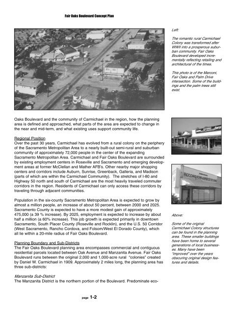
Left:<br />
The romantic rural Carmichael<br />
Colony was transformed after<br />
WWII into a prosperous suburban<br />
community. Fair Oaks<br />
Boulevard developed incrementally<br />
reflecting retailing and<br />
architectural of the times.<br />
This photo is of the Marconi,<br />
Fair Oaks and Palm Drive<br />
intersection. Some of the buildings<br />
and the palm trees still<br />
exist.<br />
Oaks Boulevard and the community of Carmichael in the region, how the planning<br />
area is defined and approached, what parts of the area are expected to change in<br />
the near and mid-term, and what existing uses support community life.<br />
Regional Position<br />
Over the past 30 years, Carmichael has evolved from a rural colony on the periphery<br />
of the Sacramento Metropolitan Area to a nearly built-out semi-rural and suburban<br />
community of approximately 72,000 people in the center of the expanding<br />
Sacramento Metropolitan Area. Carmichael and Fair Oaks Boulevard are surrounded<br />
by existing employment centers in Roseville and Sacramento and emerging development<br />
areas at former McClellan and Mather AFB’s. Other nearby major shopping<br />
centers and corridors include Auburn, Sunrise, Greenback, Galleria, and Madison<br />
(parts of which are within the Carmichael Community). The stretches of I-80 and<br />
Highway 50 north and south of Carmichael are the most heavily traveled commuter<br />
corridors in the region. Residents of Carmichael can only access these corridors by<br />
traveling through adjacent communities.<br />
Population in the six-county Sacramento Metropolitan Area is expected to grow by<br />
almost a million people, an increase of about 50 percent, between 2000 and 2025.<br />
Sacramento County is expected to have a more modest gain of approximately<br />
475,000 (a 39 % increase). By 2025, employment is expected to increase by about<br />
half a million (a 60% increase). This job growth is expected primarily in downtown<br />
Sacramento, South Placer County (Roseville and Rocklin), and the U.S. 50 Corridor<br />
(West Sacramento, Rancho Cordova, and Folsom/West El Dorado County), which<br />
all lie within a 20-mile radius of Fair Oaks Boulevard.<br />
Planning Boundary and Sub-Districts<br />
The Fair Oaks Boulevard planning area encompasses commercial and contiguous<br />
residential parcels located between Oak Avenue and Manzanita Avenue. Fair Oaks<br />
Boulevard runs between the original 2,000 and 1,000-acre rural “colonies” created<br />
by Daniel W. Carmichael in 1909. Approximately 2 miles long, the planning area has<br />
three sub-districts:<br />
Above:<br />
Some of the original<br />
Carmichael Colony structures<br />
can be found in the planning<br />
area. These smaller buildings<br />
have been home to several<br />
generations of local businesses.<br />
Many have been<br />
“improved” over the years<br />
obscuring original design features<br />
and details.<br />
Manzanita Sub-District<br />
The Manzanita District is the northern portion of the Boulevard. Predominate ecopage<br />
1-2


