

Carmichael's Main Street - sacog
Carmichael's Main Street - sacog
Carmichael's Main Street - sacog

You also want an ePaper? Increase the reach of your titles
YUMPU automatically turns print PDFs into web optimized ePapers that Google loves.
Principle 5. Make the Colony <strong>Main</strong> <strong>Street</strong> District a comfortable and interesting walking<br />
experience.<br />
The roadway project and new private investment should contribute to the successful<br />
evolution of Fair Oaks Boulevard into a mixed-mode district. <strong>Street</strong>scape, landscaping,<br />
pedestrian routes, building placement and design and open spaces should all<br />
make walking the preferred mode to traverse the district.<br />
Framework Plan Concepts<br />
The planning framework for the district addresses all three of Fair Oaks Boulevard’s<br />
sub-districts at a conceptual level and the Colony <strong>Main</strong> <strong>Street</strong> Sub-District in greater<br />
detail. Generally, the overall traditional role of the sub-districts is enhanced.<br />
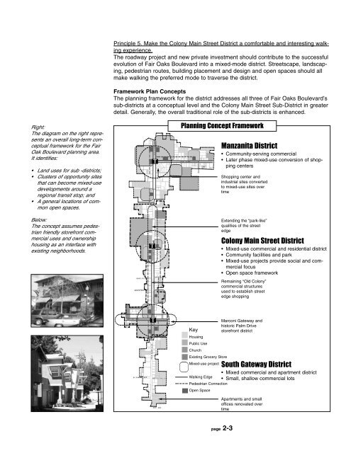
Right:<br />
The diagram on the right represents<br />
an overall long-term conceptual<br />
framework for the Fair<br />
Oak Boulevard planning area.<br />
It identifies:<br />
• Land uses for sub -districts;<br />
• Clusters of opportunity sites<br />
that can become mixed-use<br />
developments around a<br />
regional transit stop; and<br />
• A general locations of common<br />
open spaces.<br />
Below:<br />
The concept assumes pedestrian<br />
friendly storefront commercial<br />
uses and ownership<br />
housing as an interface with<br />
existing neighborhoods.<br />
T<br />
T<br />
Planning Concept Framework<br />
Manzanita District<br />
• Community-serving commercial<br />
• Later phase mixed-use conversion of shopping<br />
centers<br />
Shopping center and<br />
industrial sites converted<br />
to mixed-use sites over<br />
time<br />
Extending the “park-like”<br />
qualities of the street<br />
edge<br />
Colony <strong>Main</strong> <strong>Street</strong> District<br />
• Mixed-use commercial and residential district<br />
• Community facilities and park<br />
• Mixed-use projects provide social and commercial<br />
focus<br />
• Open space framework<br />
Remaining “Old Colony”<br />
commercial structures<br />
used to establish street<br />
edge shopping<br />
T<br />
Key<br />
Housing<br />
Public Use<br />
Church<br />
Existing Grocery Store<br />
Mixed-use project<br />
Walking Edge<br />
Pedestrian Connection<br />
Open Space<br />
Marconi Gateway and<br />
historic Palm Drive<br />
storefront district<br />
South Gateway District<br />
• Mixed commercial and apartment district<br />
• Small, shallow commercial lots<br />
Apartments and small<br />
offices renovated over<br />
time<br />
page 2-3


