ATM-Weather Integration Plan - Joint Planning and Development ...
ATM-Weather Integration Plan - Joint Planning and Development ...
ATM-Weather Integration Plan - Joint Planning and Development ...

You also want an ePaper? Increase the reach of your titles
YUMPU automatically turns print PDFs into web optimized ePapers that Google loves.
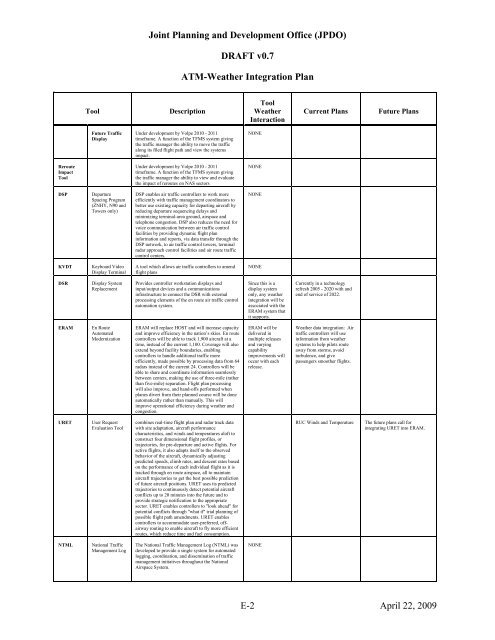
<strong>Joint</strong> <strong>Plan</strong>ning <strong>and</strong> <strong>Development</strong> Office (JPDO)<br />
DRAFT v0.7<br />
<strong>ATM</strong>-<strong>Weather</strong> <strong>Integration</strong> <strong>Plan</strong><br />
Tool<br />
Description<br />
Tool<br />
<strong>Weather</strong><br />
Interaction<br />
Current <strong>Plan</strong>s<br />
Future <strong>Plan</strong>s<br />
Future Traffic<br />
Display<br />
Under development by Volpe 2010 - 2011<br />
timeframe. A function of the TFMS system giving<br />
the traffic manager the ability to move the traffic<br />
along its filed flight path <strong>and</strong> view the systems<br />
impact.<br />
NONE<br />
Reroute<br />
Impact<br />
Tool<br />
Under development by Volpe 2010 - 2011<br />
timeframe. A function of the TFMS system giving<br />
the traffic manager the ability to view <strong>and</strong> evaluate<br />
the impact of reroutes on NAS sectors<br />
NONE<br />
DSP<br />
Departure<br />
Spacing Program<br />
(ZNHY, N90 <strong>and</strong><br />
Towers only)<br />
DSP enables air traffic controllers to work more<br />
efficiently with traffic management coordinators to<br />
better use existing capacity for departing aircraft by<br />
reducing departure sequencing delays <strong>and</strong><br />
minimizing terminal-area ground, airspace <strong>and</strong><br />
telephone congestion. DSP also reduces the need for<br />
voice communication between air traffic control<br />
facilities by providing dynamic flight plan<br />
information <strong>and</strong> reports, via data transfer through the<br />
DSP network, to air traffic control towers, terminal<br />
radar approach control facilities <strong>and</strong> air route traffic<br />
control centers.<br />
NONE<br />
KVDT<br />
Keyboard Video<br />
Display Terminal<br />
A tool which allows air traffic controllers to amend<br />
flight plans<br />
NONE<br />
DSR<br />
Display System<br />
Replacement<br />
Provides controller workstation displays <strong>and</strong><br />
input/output devices <strong>and</strong> a communications<br />
infrastructure to connect the DSR with external<br />
processing elements of the en route air traffic control<br />
automation system.<br />
Since this is a<br />
display system<br />
only, any weather<br />
integration will be<br />
associated with the<br />
ERAM system that<br />
it supports.<br />
Currently in a technology<br />
refresh 2005 - 2020 with <strong>and</strong><br />
end of service of 2022.<br />
ERAM<br />
En Route<br />
Automated<br />
Modernization<br />
ERAM will replace HOST <strong>and</strong> will increase capacity<br />
<strong>and</strong> improve efficiency in the nation’s skies. En route<br />
controllers will be able to track 1,900 aircraft at a<br />
time, instead of the current 1,100. Coverage will also<br />
extend beyond facility boundaries, enabling<br />
controllers to h<strong>and</strong>le additional traffic more<br />
efficiently, made possible by processing data from 64<br />
radars instead of the current 24. Controllers will be<br />
able to share <strong>and</strong> coordinate information seamlessly<br />
between centers, making the use of three-mile (rather<br />
than five-mile) separation. Flight plan processing<br />
will also improve, <strong>and</strong> h<strong>and</strong>-offs performed when<br />
planes divert from their planned course will be done<br />
automatically rather than manually. This will<br />
improve operational efficiency during weather <strong>and</strong><br />
congestion.<br />
ERAM will be<br />
delivered in<br />
multiple releases<br />
<strong>and</strong> varying<br />
capability<br />
improvements will<br />
occur with each<br />
release.<br />
<strong>Weather</strong> data integration: Air<br />
traffic controllers will use<br />
information from weather<br />
systems to help pilots route<br />
away from storms, avoid<br />
turbulence, <strong>and</strong> give<br />
passengers smoother flights.<br />
URET<br />
User Request<br />
Evaluation Tool<br />
combines real-time flight plan <strong>and</strong> radar track data<br />
with site adaptation, aircraft performance<br />
characteristics, <strong>and</strong> winds <strong>and</strong> temperatures aloft to<br />
construct four dimensional flight profiles, or<br />
trajectories, for pre-departure <strong>and</strong> active flights. For<br />
active flights, it also adapts itself to the observed<br />
behavior of the aircraft, dynamically adjusting<br />
predicted speeds, climb rates, <strong>and</strong> descent rates based<br />
on the performance of each individual flight as it is<br />
tracked through en route airspace, all to maintain<br />
aircraft trajectories to get the best possible prediction<br />
of future aircraft positions. URET uses its predicted<br />
trajectories to continuously detect potential aircraft<br />
conflicts up to 20 minutes into the future <strong>and</strong> to<br />
provide strategic notification to the appropriate<br />
sector. URET enables controllers to "look ahead" for<br />
potential conflicts through "what if" trial planning of<br />
possible flight path amendments. URET enables<br />
controllers to accommodate user-preferred, offairway<br />
routing to enable aircraft to fly more efficient<br />
routes, which reduce time <strong>and</strong> fuel consumption.<br />
RUC Winds <strong>and</strong> Temperature<br />
The future plans call for<br />
integrating URET into ERAM.<br />
NTML<br />
National Traffic<br />
Management Log<br />
The National Traffic Management Log (NTML) was<br />
developed to provide a single system for automated<br />
logging, coordination, <strong>and</strong> dissemination of traffic<br />
management initiatives throughout the National<br />
Airspace System.<br />
NONE<br />
E-2 April 22, 2009