Tidal_PAD_V1_Sec4.pdf - Snohomish County PUD
Tidal_PAD_V1_Sec4.pdf - Snohomish County PUD
Tidal_PAD_V1_Sec4.pdf - Snohomish County PUD

You also want an ePaper? Increase the reach of your titles
YUMPU automatically turns print PDFs into web optimized ePapers that Google loves.
<strong>Snohomish</strong> <strong>County</strong> <strong>PUD</strong> – Pre-Application Document<br />
4 – Description of Existing Environment<br />
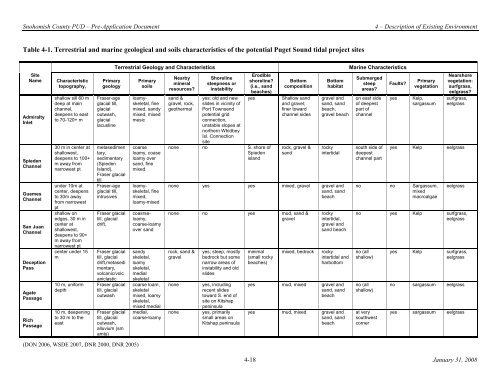
Table 4-1. Terrestria l an d marine geological and soils characteris tics of the potential Puget Sound tidal project sites<br />
Site<br />
Name Characteristic<br />
Primary<br />
topography, geology<br />
Admiralty<br />
Inlet<br />
Spieden<br />
Channel<br />
Guemes<br />
Channel<br />
San Juan<br />
Channel<br />
Deception<br />
Pass<br />
Agate<br />
Passage<br />
Rich<br />
Passage<br />
shallow sill 60 m<br />
deep at main<br />
channel,<br />
deepens to east<br />
to 70-120+ m<br />
30 m in center at<br />
shallowest,<br />
deepens to 100+<br />
m away from<br />
narrowest pt<br />
under 10m at<br />
center, deepens<br />
to 30m away<br />
from narrowest<br />
pt<br />
shallow on<br />
edges, 30 m in<br />
center at<br />
shallowest,<br />
deepens to 90+<br />
m away from<br />
narrowest pt<br />
center under 15<br />
m<br />
10 m, uniform<br />
depth<br />
10 m, deepening<br />
to 30 m to the<br />
east<br />
Fraser-age<br />
glacial till,<br />
glacial<br />
outwash,<br />
glacial<br />
lacustine<br />
metasedimen<br />
tary,<br />
sedimentary<br />
(Spieden<br />
Island),<br />
Fraser glacial<br />
till<br />
Fraser-age<br />
glacial till,<br />
intrusives<br />
Fraser glacial<br />
till, glacial<br />
drift,<br />
Fraser glacial<br />
till, glacial<br />
drift,metasedi<br />
mentary,<br />
volcanic/volc<br />
aniclastic<br />
Fraser glacial<br />
till, glacial<br />
outwash<br />
Fraser glacial<br />
till, glacial<br />
outwash,<br />
alluvium (sm<br />
amts)<br />
(DON 2006, WSDE 2007, DNR 2000, DNR 2005)<br />
Terrestrial Geology and Characteristics<br />
Marine Characteristics<br />
Primary<br />
soils<br />
loamyskeletal,<br />
fine<br />
mixed, sandy<br />
mixed, mixed<br />
mesic<br />
coarse<br />
loamy, coase<br />
loamy over<br />
sand, fine<br />
mixed<br />
loamyskeletal,<br />
fine<br />
mixed,<br />
loamy-mixed<br />
coasrseloamy,<br />
coarse-loamy<br />
over sand<br />
sandy<br />
skeletal,<br />
loamy<br />
skeletal,<br />
medial<br />
skeletal<br />
coarse loam,<br />
skeletal<br />
mixed, loamy<br />
skeletal,<br />
mixed medial<br />
medial,<br />
coarse-loamy<br />
Nearby<br />
mineral<br />
resources?<br />
sand &<br />
gravel, rock,<br />
geothermal<br />
Shoreline<br />
steepness or<br />
instability<br />
yes; old and new<br />
slides in vicinity of<br />
Port Townsend<br />
potential grid<br />
connection,<br />
unstable slopes at<br />
northern Whidbey<br />
Isl. Connection<br />
site<br />
Erodible<br />
shoreline?<br />
(i.e., sand<br />
beaches)<br />
yes<br />
none no S. shore of<br />
Spieden<br />
island<br />
Bottom<br />
composition<br />
Sha llow sand<br />
and gravel;<br />
finer toward<br />
channel sides<br />
rock, gravel &<br />
sand<br />
Bottom<br />
habitat<br />
gravel and<br />
sand, sand<br />
beach,<br />
gravel beach<br />
rocky<br />
intertidal<br />
none yes yes mixed, gravel gravel and<br />
sand, sand<br />
beach<br />
none no yes mud, sand &<br />
gravel<br />
rocky<br />
intertidal,<br />
gravel and<br />
sand beach<br />
rock, sand &<br />
gravel<br />
yes; steep, mostly<br />
bedrock but some<br />
narrow areas of<br />
minimal<br />
(small rocky<br />
beaches)<br />
mixed, bedrock rocky<br />
inte rtidal and<br />
har bottom<br />
instability and old<br />
slides<br />
none<br />
none<br />
yes, including<br />
recent slides<br />
toward S. end of<br />
site on Kitshap<br />
peninsula<br />
yes, primarily<br />
small areas on<br />
Kitshap peninsula<br />
yes<br />
yes<br />
mud, mixed gravel and<br />
sand, sand<br />
beach<br />
mud, mixed gravel and<br />
sand, sand<br />
beach<br />
Submerged<br />
steep<br />
areas?<br />
on east side<br />
of deepest<br />
part of<br />
channel<br />
south side of<br />
deepest<br />
channel part<br />
Faults?<br />
yes<br />
yes<br />
Primary<br />
vegetation<br />
Kelp,<br />
sargassum<br />
Kelp<br />
no no Sargassum,<br />
mixed<br />
macroalgae<br />
Nearshore<br />
vegetation:<br />
surfgrass,<br />
eelgrass?<br />
surfgrass,<br />
eelgrass<br />
eelgrass<br />
eelgrass<br />
no yes Kelp surfgrass,<br />
eelgrass<br />
no (all<br />
shallow)<br />
no (all<br />
shallow)<br />
at very<br />
southwest<br />
corner<br />
yes<br />
no<br />
yes<br />
Kelp<br />
sargassum<br />
sargassum<br />
surfgrass,<br />
eelgrass<br />
eelgrass<br />
eelgrass<br />
4-18 January 31, 2008