Semantic Interpretation of Digital Aerial Images Utilizing ...
Semantic Interpretation of Digital Aerial Images Utilizing ...
Semantic Interpretation of Digital Aerial Images Utilizing ...

You also want an ePaper? Increase the reach of your titles
YUMPU automatically turns print PDFs into web optimized ePapers that Google loves.
PhD Thesis<br />
<strong>Semantic</strong> <strong>Interpretation</strong> <strong>of</strong> <strong>Digital</strong> <strong>Aerial</strong><br />
<strong>Images</strong> <strong>Utilizing</strong> Redundancy, Appearance and<br />
3D Information<br />
Stefan Kluckner<br />
————————————–<br />
Graz University <strong>of</strong> Technology<br />
Institute for Computer Graphics and Vision<br />
Thesis supervisors<br />
Pr<strong>of</strong>. Dr. Horst Bisch<strong>of</strong><br />
Pr<strong>of</strong>. Dr.-Ing. Wolfgang Förstner<br />
Graz, February 2011
Our heads are round so our thoughts can<br />
change direction.<br />
Francis Picabia
Statutory Declaration<br />
I declare that I have authored this thesis independently, that I have not used other than<br />
the declared sources / resources, and that I have explicitly marked all material which has<br />
been quoted either literally or by content from the used sources.<br />
Place Date Signature<br />
Eidesstattliche Erklärung<br />
Ich erkläre an Eides statt, dass ich die vorliegende Arbeit selbstständig verfasst, andere<br />
als die angegebenen Quellen/Hilfsmittel nicht benutzt, und die den benutzten Quellen<br />
wörtlich und inhaltlich entnommene Stellen als solche kenntlich gemacht habe.<br />
Ort Datum Unterschrift
Acknowledgement<br />
First <strong>of</strong> all, I would like to express my deepest gratitude to my advisor Horst<br />
Bisch<strong>of</strong>, who permitted me to pursue a PhD at the Institute for Computer<br />
Graphics and Vision. Thank you for giving me the opportunity to experiment<br />
in the exciting field <strong>of</strong> computer vision and for your support and advice during<br />
my years at the ICG. I am also grateful to Franz Leberl for providing me with<br />
innovative and optimistic ideas and for inspiring me to publish at photogrammetric<br />
conferences. Many thanks to my second adviser, Pr<strong>of</strong>essor Wolfgang<br />
Förstner for his valuable and constructive comments at the final step <strong>of</strong> this<br />
thesis. Moreover, I would like to thank the people working at Micros<strong>of</strong>t Photogrammetry:<br />
Joachim Bauer, Michael Grabner, Konrad Karner and Barbara<br />
Gruber-Geymayer, for their help on how to manage the enormous amount <strong>of</strong><br />
aerial data successfully. I would like to express my appreciation to my colleagues<br />
from the ICG’s vision group. Especially the meetings <strong>of</strong> the Virtual<br />
Habitat group have led to many fruitful discussions about further research<br />
directions. I want to thank Tom M., Mike, Helmut, Markus U., Martin U.<br />
and Thuy for sharing ideas and writing one or two papers together with me.<br />
A special thank goes to Hayko for being my conference room mate and for<br />
pro<strong>of</strong>-reading and another special thank you to Peter and Tom P. for their help<br />
and patience in answering my many questions. Furthermore, I would like to<br />
thank the administrative staff <strong>of</strong> the ICG Renate, Christina, Manuela, Karin<br />
and Andi. I am grateful to my colleagues and friends Arnold, Manni, Philipp<br />
and Suri, which whom I spent many amusing c<strong>of</strong>fee breaks, non-scientific<br />
lunch hours in the park and long after-work sessions. Above all, I am very<br />
grateful to all my friends and my family - my father, mother, sister and my<br />
grand parents, even though they still do not understand what my work is all<br />
about. Most importantly, I would like to thank Claudia for her love, support<br />
and patience during busy times <strong>of</strong> completing this thesis.
This thesis was created at the Institute for Computer Graphics and Vision at Graz University<br />
<strong>of</strong> Technology between 2007 and 2010. During this time, the work was supported<br />
by the Austrian FFG project APAFA (813397) under the FIT-IT program and the Austrian<br />
Science fund under the doctoral program Confluence <strong>of</strong> Vision and Graphics W1209.
Abstract<br />
One <strong>of</strong> the fundamental problems in the area <strong>of</strong> digital image processing is the automated<br />
and detailed understanding <strong>of</strong> image contents. This task <strong>of</strong> automated image understanding<br />
covers the explanation <strong>of</strong> images through assigning a semantic class label<br />
to mapped objects, as well as the determination <strong>of</strong> their extents, locations and relationships.<br />
Occlusions, changes <strong>of</strong> illumination, viewpoint and scale, natural or man-made<br />
structures, shape-defined objects or formless, homogeneous and highly-textured materials<br />
complicate the task <strong>of</strong> semantic image interpretation. While purely appearance-driven<br />
approaches obtain reliable interpretation results on benchmark datasets, there is a trend<br />
toward a compact integration <strong>of</strong> visual cues and 3D scene geometry. Accurately estimating<br />
3D structure from images has already reached a state <strong>of</strong> maturity, mainly due to<br />
the cheap acquisition <strong>of</strong> highly redundant data and parallel hardware. Particularly, scene<br />
information taken from multiple viewpoints results in dense 3D structures that describe<br />
the 3D shapes <strong>of</strong> the mapped objects. This thesis therefore presents methods that utilize<br />
available appearance and 3D information extensively. In the context <strong>of</strong> highly-redundant<br />
digital aerial imagery we derive a holistic description for urban environments from color<br />
and available range images. A novel statistical feature representation and efficient multiclass<br />
learners <strong>of</strong>fer the mapping <strong>of</strong> compactly combined congruent cues - composed <strong>of</strong><br />
color, texture and elevation measurements – to probabilistic object class assignments for<br />
every pixel. On the basis <strong>of</strong> the derived holistic scene description, variational fusion<br />
steps integrate highly redundant observations to form high-quality results for each modality<br />
in an orthographic view. We finally demonstrate that the holistic description, which<br />
combines color, surface models and semantic classification, can be used to construct interpreted<br />
large-scale building models that are described by only a few parameters. In<br />
the experimental evalutation we examine the results with respect to available redundancy,<br />
correctly assigned object classes, as well as to obtained noise suppression. For the evaluation<br />
we use real-world aerial imagery, showing urban environments <strong>of</strong> Dallas, Graz and<br />
San Francisco, besides standard benchmark datasets.
Kurzfassung<br />
Eines der grundlegenden Probleme im Bereich der digitalen Bildverarbeitung ist das automatische<br />
und detaillierte Verstehen von Bildinhalten. Die Aufgabe der automatischen<br />
Erklärung von Bildern umfasst die <strong>Interpretation</strong> der Bilder durch die Zuweisung einer<br />
semantischen Bezeichnung abgebildeter Objekte, sowie die Bestimmung von deren Ausbreitung,<br />
Positionen und Beziehungen. Verdeckungen, wechselnde Beleuchtung, Blickrichtungen<br />
und Größen, natürliche oder vom Menschen geschaffene Strukturen, formdefinierte<br />
Objekte oder formlose, homogene und strukturierte Materialien erschweren<br />
die Aufgabe der semantischen <strong>Interpretation</strong> von Bildern. Während rein visuell-basierte<br />
Ansätze zuverlässige Ergebnisse auf Vergleichsdatensätzen erzielen, ist ein Trend zur<br />
kompakten Integration von visueller Information und 3D Szenen Geometrie erkennbar.<br />
Die exakte Schätzung der 3D Struktur von Bildern hat bereits Marktreife erreicht, vorallem<br />
aufgrund der kostengünstigen Generierung von hoch-redundanten Daten und erschwinglicher<br />
Hardware mit Parallelberechnungsunterstützung. Besonders Szenen Information,<br />
aufgenommen aus mehreren Blickwinkeln, ermöglicht die Berechnung vollständiger<br />
3D-Strukturen, welche die 3D-Formen der abgebildeten Objekte beschreiben. Diese<br />
Arbeit behandelt Methoden, die das vorhandene Erscheinungsbild, sowie 3D-Information<br />
umfassend ausnützen. Im Kontext von hoch-redundanten digitalen Luftbildern präsentieren<br />
wir Ansätze für die Berechnung einer ganzheitlichen Beschreibung für urbane<br />
Lebensräume aus Farbe und Tiefenbildern. Eine neue statistische Merkmalsrepräsentation<br />
und effiziente Klassifikatoren für mehrere Objektklassen bieten eine schnelle Projektion<br />
kongruenter Messungen von Farbe, Textur und Höhenwerten zu probabilistischen<br />
Klassenzuweisungen für jeden Bildpunkt. Aufgrund der ganzheitlichen Szenenbeschreibung<br />
können redundante Beobachtungen mittels Variationsmethoden zu qualitativ hochwertigen<br />
Ergebnissen für jede Modalität in einer orthographischen Ansicht fusioniert werden.<br />
Wir zeigen abschließend, dass diese ganzheitliche Beschreibung, bestehend aus<br />
Farbe, Oberflächenmodell und semantischer <strong>Interpretation</strong>, für die großflächige Berechnung<br />
von Gebäudemodellen mit wenigen Parametereinstellungen herangezogen werden
kann. Mittels synthetisch erzeugter Modelle untersuchen wir in Experimenten die erzielten<br />
Ergebnisse im Hinblick auf vorliegender Redundanz, korrekt zugeordneter Objektklassen,<br />
sowie erzielter Rauschunterdrückung. Für die Auswertung nutzen wir neben<br />
Vergleichsdatensätzen, reale Luftbildaufnahmen von Dallas, Graz und San Francisco.
Contents<br />
1 Introduction 1<br />
1.1 <strong>Aerial</strong> Photogrammetry . . . . . . . . . . . . . . . . . . . . . . . . . . . 1<br />
1.2 Photo-realistic Modeling vs. Virtual Cities . . . . . . . . . . . . . . . . . 3<br />
1.3 <strong>Semantic</strong> <strong>Interpretation</strong> <strong>of</strong> <strong>Aerial</strong> <strong>Images</strong> . . . . . . . . . . . . . . . . . . 4<br />
1.4 Contributions . . . . . . . . . . . . . . . . . . . . . . . . . . . . . . . . 7<br />
1.5 Outline . . . . . . . . . . . . . . . . . . . . . . . . . . . . . . . . . . . 9<br />
2 <strong>Digital</strong> <strong>Aerial</strong> Imagery 11<br />
2.1 <strong>Aerial</strong> Photography . . . . . . . . . . . . . . . . . . . . . . . . . . . . . 11<br />
2.2 Redundancy . . . . . . . . . . . . . . . . . . . . . . . . . . . . . . . . . 12<br />
2.3 <strong>Digital</strong> Surface Model . . . . . . . . . . . . . . . . . . . . . . . . . . . . 15<br />
2.4 <strong>Digital</strong> Terrain Model . . . . . . . . . . . . . . . . . . . . . . . . . . . . 20<br />
2.5 Orthographic Image Representation . . . . . . . . . . . . . . . . . . . . 20<br />
2.6 Datasets . . . . . . . . . . . . . . . . . . . . . . . . . . . . . . . . . . . 22<br />
2.7 Summary . . . . . . . . . . . . . . . . . . . . . . . . . . . . . . . . . . 23<br />
3 From Appearance and 3D to Interpreted Image Pixels 25<br />
3.1 Introduction . . . . . . . . . . . . . . . . . . . . . . . . . . . . . . . . . 25<br />
3.2 Overview . . . . . . . . . . . . . . . . . . . . . . . . . . . . . . . . . . 27<br />
3.3 Related Work . . . . . . . . . . . . . . . . . . . . . . . . . . . . . . . . 28<br />
3.4 Feature Representation . . . . . . . . . . . . . . . . . . . . . . . . . . . 31<br />
3.4.1 Mean and Covariance Descriptors . . . . . . . . . . . . . . . . . 32<br />
3.4.2 Working with Symmetric Positive-Definite Matrices . . . . . . . 33<br />
3.4.3 Generating Correlated Samples . . . . . . . . . . . . . . . . . . 38<br />
3.4.4 Sigma Points Representation . . . . . . . . . . . . . . . . . . . . 40<br />
3.4.5 Feature Representation for the <strong>Semantic</strong> <strong>Interpretation</strong> . . . . . . 41<br />
3.4.6 Integral Image Structures . . . . . . . . . . . . . . . . . . . . . . 42<br />
i
ii<br />
CONTENTS<br />
3.5 Randomized Forest Classifier . . . . . . . . . . . . . . . . . . . . . . . . 44<br />
3.6 Introducing Segmentation for Object Delineation . . . . . . . . . . . . . 46<br />
3.7 Refined Labeling . . . . . . . . . . . . . . . . . . . . . . . . . . . . . . 49<br />
3.8 Experiments on Benchmark Datasets . . . . . . . . . . . . . . . . . . . . 51<br />
3.8.1 Evaluation Metric . . . . . . . . . . . . . . . . . . . . . . . . . . 53<br />
3.8.2 Sigma Points and Randomized Forest . . . . . . . . . . . . . . . 53<br />
3.8.3 Initial <strong>Interpretation</strong> <strong>of</strong> Benchmark <strong>Images</strong> . . . . . . . . . . . . 57<br />
3.8.4 Introducing Segmentation and Refined Labeling . . . . . . . . . 59<br />
3.9 Experiments on <strong>Aerial</strong> <strong>Images</strong> . . . . . . . . . . . . . . . . . . . . . . . 62<br />
3.9.1 Manually Labeling . . . . . . . . . . . . . . . . . . . . . . . . . 63<br />
3.9.2 Binary Building Classification . . . . . . . . . . . . . . . . . . . 65<br />
3.9.3 <strong>Semantic</strong> <strong>Interpretation</strong> into Five Object Classes . . . . . . . . . 66<br />
3.9.4 Improving the Initial Classification Result . . . . . . . . . . . . . 68<br />
3.10 Discussion and Summary . . . . . . . . . . . . . . . . . . . . . . . . . . 73<br />
4 From 3D to the Fusion <strong>of</strong> Redundant Pixel Observations 79<br />
4.1 Introduction . . . . . . . . . . . . . . . . . . . . . . . . . . . . . . . . . 80<br />
4.2 Introducing a Common View . . . . . . . . . . . . . . . . . . . . . . . . 83<br />
4.3 Fusion <strong>of</strong> Redundant Intensity Information . . . . . . . . . . . . . . . . . 84<br />
4.3.1 Background . . . . . . . . . . . . . . . . . . . . . . . . . . . . . 84<br />
4.3.2 The Proposed Model . . . . . . . . . . . . . . . . . . . . . . . . 87<br />
4.3.3 Primal-Dual Formulation . . . . . . . . . . . . . . . . . . . . . . 88<br />
4.3.4 Extension to a Wavelet-based Regularization . . . . . . . . . . . 90<br />
4.4 Fusion <strong>of</strong> Redundant Classification Information . . . . . . . . . . . . . . 91<br />
4.4.1 Accumulation <strong>of</strong> the Classifier Output . . . . . . . . . . . . . . . 92<br />
4.4.2 Refined Labeling Within the Orthographic View . . . . . . . . . 92<br />
4.5 Experiments . . . . . . . . . . . . . . . . . . . . . . . . . . . . . . . . . 95<br />
4.5.1 Experiments on Height Data Fusion . . . . . . . . . . . . . . . . 96<br />
4.5.2 Experiments on Color Fusion . . . . . . . . . . . . . . . . . . . 99<br />
4.5.3 Experiments on Classification Fusion . . . . . . . . . . . . . . . 107<br />
4.6 Discussion and Summary . . . . . . . . . . . . . . . . . . . . . . . . . . 121<br />
5 From Interpreted Regions to 3D Models 127<br />
5.1 Introduction . . . . . . . . . . . . . . . . . . . . . . . . . . . . . . . . . 128<br />
5.2 Related Work . . . . . . . . . . . . . . . . . . . . . . . . . . . . . . . . 130<br />
5.3 Overview . . . . . . . . . . . . . . . . . . . . . . . . . . . . . . . . . . 131<br />
5.4 Building Modeling based on Super-Pixels . . . . . . . . . . . . . . . . . 133<br />
5.4.1 Prototype Extraction . . . . . . . . . . . . . . . . . . . . . . . . 135<br />
5.4.2 Prototype Clustering . . . . . . . . . . . . . . . . . . . . . . . . 136
CONTENTS<br />
iii<br />
5.4.3 Prototype Refinement . . . . . . . . . . . . . . . . . . . . . . . 137<br />
5.4.4 Ro<strong>of</strong>top Modeling . . . . . . . . . . . . . . . . . . . . . . . . . 139<br />
5.5 Experiments . . . . . . . . . . . . . . . . . . . . . . . . . . . . . . . . . 140<br />
5.6 Discussion and Summary . . . . . . . . . . . . . . . . . . . . . . . . . . 144<br />
6 Conclusion 149<br />
6.1 Summary . . . . . . . . . . . . . . . . . . . . . . . . . . . . . . . . . . 150<br />
6.2 Outlook . . . . . . . . . . . . . . . . . . . . . . . . . . . . . . . . . . . 151<br />
6.2.1 Training Data . . . . . . . . . . . . . . . . . . . . . . . . . . . . 151<br />
6.2.2 Joint Estimation <strong>of</strong> 3D and <strong>Semantic</strong> <strong>Interpretation</strong> . . . . . . . . 152<br />
6.2.3 Virtual Cities and GIS Enrichment . . . . . . . . . . . . . . . . . 152<br />
A Publications 153<br />
B Acronyms 157
iv<br />
CONTENTS
Chapter 1<br />
Introduction<br />
Three-dimensional reconstruction and object recognition are two major trends, that dominate<br />
the current research in both computer vision and photogrammetry. The automatic estimation<br />
<strong>of</strong> the geometry <strong>of</strong> arbitrary image scenes has already reached a state <strong>of</strong> maturity,<br />
due to highly redundant image data and increased computational power through multicore<br />
systems. They enable stereo or multi-view matching methods that result in highly<br />
accurate 3D scene information, e.g., [Hirschmüller, 2006, Agarwal et al., 2009, Goesele<br />
et al., 2010,Frahm et al., 2010,Irschara, 2011]. Although object recognition has been studied<br />
as intensively as 3D reconstruction, it is still a wide area <strong>of</strong> active research. Especially<br />
huge inter- and intra-class variabilities, scale and illumination changes and partial occlusions<br />
present research with a challenge. The semantic interpretation <strong>of</strong> high-resolution<br />
aerial images is a particularly difficult task, since every pixel must be assigned a semantic<br />
class label. In this thesis we face these challenges by arguing, that it is essential to integrate<br />
available appearance cues, such as color and texture, and 3D information, computed<br />
from overlapping scene observations, for the task <strong>of</strong> semantic interpretation. Combining<br />
congruent color, 3D information and semantic knowledge about an observed scene takes<br />
us a giant step toward a full image understanding and holistic description. We therefore<br />
propose concepts, that utilize redundant input sources exceedingly and investigate the interaction<br />
between appearance and scene geometry to improve the task <strong>of</strong> aerial image<br />
understanding.<br />
1.1 <strong>Aerial</strong> Photogrammetry<br />
<strong>Aerial</strong> mapping is important to governmental and commercial organizations all over the<br />
world. During the last two decades digital cameras have started to replace traditional<br />
analogue cameras and took over the market <strong>of</strong> aerial photogrammetry, as a result <strong>of</strong> their<br />
enhanced stability and resolution [Leberl et al., 2003]. Figure 1.1 demonstrates the quality<br />
1
2 Chapter 1. Introduction<br />
Figure 1.1: Small image patches cropped from huge digital aerial images at pixel sizes<br />
<strong>of</strong> 8 cm and 15 cm, respectively. One can notice that fine image details, such as walking<br />
people, vegetation or railway tracks are preserved accurately.<br />
<strong>of</strong> digital aerial images at pixel sizes <strong>of</strong> 8 cm to 15 cm. Although these images are taken<br />
in flight heights <strong>of</strong> approximately 1000 m, one can recognize fine details like pedestrians<br />
and railway tracks.<br />
<strong>Digital</strong> aerial photogrammetry today <strong>of</strong>fers various applications, that permit the creation<br />
<strong>of</strong> accurate surface models, as well as the generation <strong>of</strong> eye-candy orthographic images<br />
and the construction <strong>of</strong> detailed models <strong>of</strong> urban environments, visualized efficiently<br />
on the Internet. For example, location-aware applications, like the initiatives Micros<strong>of</strong>t<br />
Bing Maps and Google Earth, aim at reconstructing all major cities <strong>of</strong> the world in order<br />
to <strong>of</strong>fer accurate virtual models <strong>of</strong> real urban environments. They additionally collect<br />
meta-data about hot-spots, like touristic sights, shopping malls and churches, as well as<br />
residential houses or single trees, and link it to the aerial data to enrich location-aware<br />
search engines. Another big advantage <strong>of</strong> digital aerial mapping lies in the possibilities<br />
it <strong>of</strong>fers to Geographic Information Systems (GIS), due to low cost and efficiency.<br />
GIS applications typically include urban planning, cartography, emergency management,<br />
mapping <strong>of</strong> roads, railway lines, fiber-optic corridors or pipelines, and navigation. Especially<br />
car navigation has become ubiquitous, since it facilitates driving in foreign areas.<br />
To model entire urban environments or link aerial data to existing GIS and navigation systems<br />
automatic procedures and autonomous interpretations are needed, in order to handle<br />
the enormous amount <strong>of</strong> collected information and to understand the mapped data. These<br />
applications thus depend on an interpretation <strong>of</strong> urban scenes, which identifies roads,
1.2. Photo-realistic Modeling vs. Virtual Cities 3<br />
buildings, trees, doors, windows, parking meters, sky lights and similar objects.<br />
1.2 Photo-realistic Modeling vs. Virtual Cities<br />
The use <strong>of</strong> highly overlapping, digital aerial photography makes the computation <strong>of</strong> 3D<br />
scene information possible [Hartley and Zisserman, 2000, Kraus, 2004]. Purely imagebased<br />
methods <strong>of</strong>fer intermediate results, like surface and terrain models. While a digital<br />
surface model (DSM) includes elevation measurements for buildings, vegetation, and<br />
roads, as well as for the visible terrain, the digital terrain models (DTM) represent the<br />
bare-earth surface <strong>of</strong> which elevated objects, like man-made structures and trees, get<br />
stripped. Both models are typically represented in the form <strong>of</strong> sampled elevation measurements.<br />
Associated with the points, or triangular meshes, computed from the 3D elevation<br />
measurements, are small patches <strong>of</strong> photo-texture information directly extracted<br />
from the digital aerial images. From these intermediate results, one builds both highquality<br />
photo-textures as well as complete 3D models <strong>of</strong> urban environments. Although<br />
two-dimensional ortho-photos provide a simpler data structure, smaller data volume and<br />
a great ease <strong>of</strong> use and orientation, they do not inspire the observer. On the contrary,<br />
computed photo-realistic 3D models, consisting <strong>of</strong> huge point clouds or assemblies <strong>of</strong> triangular<br />
meshes with attached photo-texture indeed please the eye but need complex data<br />
structures, and are more difficult to use and navigate. Both representations ortho-photos<br />
and photo-realistic 3D models yet do not present any semantic knowledge that is required<br />
for navigation, searching, data mining or GIS applications. We thus cannot query the data<br />
according to content, nor can we derive specific thematic information <strong>of</strong> a specific object<br />
class.<br />
The ultimate goal must be a full explanation <strong>of</strong> all mapped objects in the scene by<br />
attaching semantic labels to them, so that one can search through these objects or model<br />
them according to the obtained interpretation. A virtual city [Nicklas, 2007], the visualization<br />
<strong>of</strong> an urban scene, will then be created from the complete description <strong>of</strong> its<br />
elements. Apart from this flexibility, there is an advantage <strong>of</strong> smaller data quantities that<br />
need to be stored, retrieved and transmitted to an user. Creating the rendering from object<br />
models additionally supports the idea <strong>of</strong> user-supportive generalization. Objects <strong>of</strong> importance,<br />
like shopping malls, restaurants, leisure areas etc., might be visualized at to the<br />
user at a level <strong>of</strong> detail (LoD) and scale, that differs from other objects <strong>of</strong> less importance.<br />
A German initiative deals with standards based on a mark-up language CityGML 1 [Kolbe<br />
et al., 2005] and describes the virtual city by five levels, starting from a LoD-0 defined<br />
by the DTM. LoD-1 is the simple rectangular model <strong>of</strong> buildings and city blocks with-<br />
1 http://www.citygml.org
4 Chapter 1. Introduction<br />
Figure 1.2: A scene <strong>of</strong> Berlin rendered and visualized in Google Earth (left) and the<br />
corresponding CityGML model (right) with overlaid buildings, represented in LoD 1 to<br />
3. Note that both models have been generated with massive human interaction.<br />
out any attention to photographic realism. This gets improved by a LoD-2 with building<br />
blocks showing generalized ro<strong>of</strong>top shapes. LoD-3 is the photo-realistic full model <strong>of</strong><br />
each building and LoD-4 contains sufficient details to enter a building. Standardized files,<br />
compactly representing the queried data, can be streamed efficiently over the Internet and<br />
get rendered immediately at the users workstation. Figure 1.2 depicts a photo-realistic<br />
visualization provided by Google Earth and a corresponding CityGML rendering <strong>of</strong> a<br />
scene located in Berlin. Similar to the CityGML standard, procedural modeling [Parish<br />
and Müller, 2001] aims at constructing synthetic 3D models and textures from sets <strong>of</strong><br />
defined rules and shape grammars.<br />
1.3 <strong>Semantic</strong> <strong>Interpretation</strong> <strong>of</strong> <strong>Aerial</strong> <strong>Images</strong><br />
In order to construct semantically enriched virtual cities that support search queries or<br />
specific information extraction, every mapped object has to be recognized and assigned<br />
a semantic class label as a first step toward a full image understanding. The problem <strong>of</strong><br />
image understanding covers the interpretation <strong>of</strong> the scene with respect to mapped objects,<br />
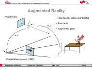
locations and the their relationships. Figure 1.3 shows a scene taken from two different<br />
viewpoints. The high overlap enables an estimation <strong>of</strong> 3D scene geometry, which can be<br />
used to improve the semantic labeling <strong>of</strong> the scene. In this thesis we treat the problem<br />
<strong>of</strong> scene understanding as a semantic labeling process, where each pixel is assigned a<br />
specific object class.<br />
Due to huge variability the task <strong>of</strong> visual scene understanding is still a largely unsolved<br />
problem. Among occlusions, illumination, viewpoint and scale changes, natural or man-
1.3. <strong>Semantic</strong> <strong>Interpretation</strong> <strong>of</strong> <strong>Aerial</strong> <strong>Images</strong> 5<br />
Figure 1.3: <strong>Semantic</strong> interpretation aims at assigning class labels to mapped objects. In<br />
this thesis we focus on a pixel-wise scene understanding by using a given set <strong>of</strong> predefined<br />
object classes. The high redundancy in the aerial data enables an estimation <strong>of</strong> the scene<br />
geometry as well as a semantic classification from different viewpoints.<br />
made structures, shape-defined (things) or formless objects (stuff ), transparent or highlytextured<br />
regions complicate the task <strong>of</strong> finding a meaningful object representation for<br />
effective scene understanding. Visual scene understanding has been addressed by a variety<br />
<strong>of</strong> prominent works [Shotton et al., 2007, Rabinovich et al., 2006, Verbeek and Triggs,<br />
2007,Gould et al., 2008,Ladicky et al., 2010a] that aim at an accurate explanation <strong>of</strong> each<br />
pixel in observed image. From these approaches, one can notice that the combination <strong>of</strong><br />
several intermediate results achieves improved recognition accuracies and is required to<br />
obtain a full description <strong>of</strong> images.<br />
<strong>Semantic</strong> image interpretation can be seen as possibly highly automatic processes for<br />
understanding and analyzing the objects shown in arbitrary images. These processes include<br />
object detection, aiming at tagging objects <strong>of</strong> a particular target class with a bounding<br />
box, but also image classification, where pixels, assemblies <strong>of</strong> pixels, parts or even
6 Chapter 1. Introduction<br />
images are assigned a label selected from a pool <strong>of</strong> predefined object classes. Object detection<br />
differs from classification in its goal. The goal <strong>of</strong> object detection is to describe,<br />
count and find an object as a whole 1 , by taking into account its visual appearance and<br />
shape, represented either in 2D or 3D.<br />
We consider image classification as a pixel-oriented process, where a single pixel or<br />
a pixel and its neighborhood are the input and a semantic class label for a single pixel is<br />
the output. In addition, the task <strong>of</strong> image classification also treats the relations between<br />
pixels within the observed image. The choice <strong>of</strong> using object classification or detection<br />
is mainly based on a discrimination into things and stuff object classes [Forsyth et al.,<br />
1996]. While things objects have a distinct size and shape, stuff can be rather seen as<br />
a material that is specified by a texture and has no ascertainable form 2 . Distinguishing<br />
between these two types leads to improvements for the task <strong>of</strong> full scene description as<br />
recently shown in [Heitz and Koller, 2008, Ladicky et al., 2010a].<br />
This thesis mainly focuses on the semantic enrichments, also referred to as landuse<br />
classification, <strong>of</strong> mapped object points, greatly represented with high-resolution and<br />
highly redundant aerial imagery. The image content gets separated into regions that typically<br />
describe buildings, circulation spaces, such as streets and parking areas or driveways,<br />
vegetation, grass surfaces and water bodies. The regions are commonly defined by assemblies<br />
<strong>of</strong> pixels forming an ineffable amount <strong>of</strong> object variabilities and spatial extends. We<br />
thus treat scene understanding as stuff classification, where each pixel is described by<br />
its local neighborhood [Shotton et al., 2007, Verbeek and Triggs, 2007]. Although there<br />
exist solely image-based interpretation approaches for aerial images [Gruber-Geymayer<br />
et al., 2005,Porway et al., 2010], none <strong>of</strong> these concepts make considerable use <strong>of</strong> a tight<br />
combination <strong>of</strong> appearance and 3D information. We therefore propose to utilize these<br />
complementary cues for a semantic enrichment <strong>of</strong> digital aerial images. For instance, using<br />
a direct combination <strong>of</strong> color and height data would successfully separate gray-valued<br />
ro<strong>of</strong>tops from streets or might be useful to distinguish between grass and elevated vegetation,<br />
like trees and bushes. Having the semantic explanation <strong>of</strong> each pixel will have a<br />
significant effect on many following tasks. We think <strong>of</strong> the way we search in images, how<br />
we can compress, publish and broadcast them on the Internet or how urban scenes get represented<br />
and visualized. Moreover, assigning an object class to each object point, brings<br />
us, together with available color and 3D information, directly to a holistic description <strong>of</strong><br />
aerial images scenes. This holistic collection supports the refinement <strong>of</strong> the obtained interpretation<br />
toward a fine-scaled description, where building blocks, ro<strong>of</strong>top landscapes,<br />
chimneys, trees etc. are represented individually.<br />
1 In detection tasks the object is usually known in principle to have a certain scale, shape or appearance<br />
2 It is obvious that the assignment <strong>of</strong> objects to the things or stuff category depends on the image acquisition,<br />
e.g., clouds or trees might then be refer to both categories
1.4. Contributions 7<br />
Figure 1.4: Overview <strong>of</strong> the proposed aerial image interpretation workflow. We utilize<br />
highly redundant color and range images for the pixel-wise explanation. A fusion step<br />
provides us with a holistic scene description, consisting <strong>of</strong> fused color, height and classification,<br />
that can be used to construct interpreted city models.<br />
1.4 Contributions<br />
In order to obtain an accurate semantic interpretation <strong>of</strong> aerial images, this thesis focuses<br />
on utilizing highly redundant appearance and 3D information cues extensively. In particular,<br />
modern digital imaging techniques enable image acquisition with high redundancy<br />
from significantly overlapping views without high additional costs. In this thesis we thus<br />
study the combination <strong>of</strong> redundancy, appearance and scene geometry for tightly interacting<br />
processing steps. Figure 1.4 summarizes the proposed workflow.
8 Chapter 1. Introduction<br />
1. From Appearance and 3D to Interpreted Image Pixels The first contribution deals<br />
with large-scale semantic interpretation <strong>of</strong> single high-resolution aerial images. In order<br />
to obtain a reliable object class assignment to each pixel in the images, we introduce a<br />
novel region descriptor, based on statistical measurements. This descriptor enables a compact<br />
and straightforward integration <strong>of</strong> appearance and 3D information without considerations<br />
about normalization issues. Since the aerial imagery provides an enormous amount<br />
<strong>of</strong> data, we exploit efficient data structures, such as integral images and fast multi-class<br />
learners. To provide a quick descriptor calculation, the proposed supervised classification<br />
approach mainly relies on a pixel-wise semantic interpretation by incorporating local<br />
neighborhoods. We also exploit unsupervised segmentation, providing important spatial<br />
support, and optimization strategies to accurately delineate the mapped objects with respect<br />
to the real edges. The suggested interpretation workflow gets first evaluated on<br />
standard benchmark datasets. For the aerial images we then demonstrate that the tight<br />
combination <strong>of</strong> appearance and 3D information is essential for an accurate semantic interpretation<br />
at the pixel level.<br />
2. From 3D to the Fusion <strong>of</strong> Redundant Pixel Observations. The second contribution<br />
studies the fusion <strong>of</strong> redundant observations for the semantic interpretation, color<br />
and height measurements. The generation <strong>of</strong> these congruent modalities is essential for a<br />
holistic scene description. Due to the high geometric redundancy <strong>of</strong> the aerial imagery and<br />
the availability <strong>of</strong> well-defined scene geometry, a projection to a common view (we employ<br />
the orthographic view) yields multiple, highly redundant pixel observations for each<br />
involved modality. We thus make use <strong>of</strong> the range images, representing the geometry, to<br />
align the overlapping perspective image information into a single view. Since the range<br />
images are prone to contain many outliers we put emphasis on optimization schemes,<br />
<strong>of</strong>fering novel regularization techniques. As a first step we exploit continuous energy<br />
minimization methods to integrate redundant scene observations for color and height.<br />
The fusion step, defined over multiple color observations, utilizes improved image priors,<br />
based on efficient wavelets. In contrast to the height field fusion, where a total-variation<br />
based regularization advances sharp edges, the wavelet regularization preserves fine structures<br />
and a natural appearance. A second step yields congruent semantic interpretation<br />
within the orthographic representation by accumulating multi-view classifications, resulting<br />
from the per-image explanation. Having the raw ortho-fused interpretation facilitates<br />
an investigation <strong>of</strong> different optimization methods with respect to correctly classified pixels<br />
and object delineation. The experiments show that the continuous formulation <strong>of</strong> the<br />
Potts model provides a simple way to capture object edges by incorporating appearance<br />
or height data within the optimization procedure.
1.5. Outline 9<br />
3. From Interpreted Regions to 3D Models. The third contribution addresses the modeling<br />
<strong>of</strong> the obtained semantic interpretation. We particularly discuss the construction <strong>of</strong><br />
fully parametrized 3D models <strong>of</strong> buildings. The proposed approach again relies on the<br />
tight interaction between semantic classification, color and height information. In a first<br />
step, we make use <strong>of</strong> unsupervised color image segmentation to extract and model any<br />
type <strong>of</strong> building footprint. Established building regions, derived from the semantic interpretation,<br />
are then assigned with individual geometric primitives efficiently estimated<br />
from the corresponding height data. A clustering yields representative geometric prototypes<br />
that are used within a final labeling procedure. This labeling strategy, defined on<br />
a reduced adjacency graph, yields a consistent and smooth modeling <strong>of</strong> the individual<br />
ro<strong>of</strong>tops, where each ro<strong>of</strong>top gets parametrized by few parameters. Available elevation<br />
measurements and a simple triangulation are subsequently used to extrude the final 3D<br />
building model, efficiently described by unique ID-number, an assembly <strong>of</strong> polygons,<br />
geometric prototypes and mean colors.<br />
1.5 Outline<br />
We detail the contributions in three technical chapters that describe the semantic interpretation<br />
<strong>of</strong> single images, the fusion <strong>of</strong> available modalities and the modeling <strong>of</strong> the<br />
obtained interpretation. For each <strong>of</strong> the main chapters, we discuss related work, outline<br />
the concepts and evaluate the methods individually. The remaining part <strong>of</strong> the thesis is<br />
thus organized as follows:<br />
Chapter 2. In Chapter 2 we briefly describe different input modalities required for the<br />
proposed algorithms. We present the basic information <strong>of</strong> the involved aerial imagery,<br />
distinguish between radiometric and geometric redundancy and explain the generation <strong>of</strong><br />
surface and terrain models.<br />
Chapter 3. Chapter 3 deals with the semantic interpretation <strong>of</strong> single images by tightly<br />
integrating appearance and height information. This chapter is divided into four parts:<br />
feature representation, feature classification, the application <strong>of</strong> unsupervised segmentation<br />
for improved object delineation and the refinement step based on energy minimization.<br />
The experimental evaluation studies the performance <strong>of</strong> the proposed interpretation<br />
workflow applied to standard image collections and aerial images.<br />
Chapter 4. Chapter 4 focuses on the fusion <strong>of</strong> massively redundant image information.<br />
While in Chapter 3 the aerial images are treated independently, this chapter aims at integrating<br />
the data from multiple perspective images. We thus highlight the generation <strong>of</strong>
10 Chapter 1. Introduction<br />
high-quality results from multiple observation for color, height and semantic interpretation.<br />
For each modality separately, optimization schemes are introduced for the fusion in<br />
an orthographic view. The evaluation section demonstrates the benefit <strong>of</strong> using the high<br />
redundancy provided by the aerial imagery.<br />
Chapter 5. In Chapter 5 we address the problem <strong>of</strong> semantic modeling by incorporating<br />
the holistic scene description obtained from Chapter 4. The main part <strong>of</strong> Chapter 5<br />
covers the extraction, parametrization and modeling <strong>of</strong> ro<strong>of</strong>top landscapes from color information,<br />
derived building regions and surface models. A detailed evaluation shows the<br />
benefit <strong>of</strong> this interaction.<br />
Chapter 6. Finally, Chapter 6 concludes the thesis with a summary <strong>of</strong> the obtained<br />
outcomes and gives and ideas for future work, that could help to improve the suggested<br />
interpretation workflow.
Chapter 2<br />
<strong>Digital</strong> <strong>Aerial</strong> Imagery<br />
This thesis aims for a largely automatic semantic interpretation <strong>of</strong> digitally mapped urban<br />
environments by utilizing massively redundant information <strong>of</strong> appearance and 3D<br />
scene information. While highly overlapping color images and corresponding geometric<br />
data are assumed to be given in advance, additional products are required to achieve<br />
the interpretation <strong>of</strong> aerial scenes. We thus outline involved modalities, ranging from<br />
redundant color and texture information, over models, representing the surface and the<br />
terrain, to estimated elevation measurements. Having the holistic collection <strong>of</strong> data applies<br />
to semantically describe entire virtual space, but also to automatically derive parameters<br />
individually specified for a certain task. In this thesis the proposed approaches<br />
largely use digital aerial images produced by the high-resolution camera Micros<strong>of</strong>t Ultra-<br />
CamD [Leberl et al., 2003]. The camera provides multi-view pixel observations, obtained<br />
by acquiring the aerial project with high overlaps, as well as multi-spectral information<br />
for mapped point, so that any applied algorithm can rely on highly redundant analysis.<br />
We first describe the digital aerial imagery and highlight the process <strong>of</strong> range image generation.<br />
This chapter further outlines the generation <strong>of</strong> additional input sources, such as<br />
the terrain model and the derivation <strong>of</strong> the elevation measurements, and discusses the orthographic<br />
image representation that is commonly used in aerial workflows. In addition,<br />
we introduce the aerial project Dallas, Graz and San Francisco.<br />
2.1 <strong>Aerial</strong> Photography<br />
<strong>Digital</strong> aerial mapping has become feasible with the first large-format digital aerial cameras<br />
in the beginning <strong>of</strong> the 21st century. To compete with at that time traditionally used<br />
film images, these digital cameras had to <strong>of</strong>fer an image width <strong>of</strong> at least <strong>of</strong> 11000 pixels<br />
and a color band including RGB and infrared channels [Leberl et al., 2003]. The first dig-<br />
11
12 Chapter 2. <strong>Digital</strong> <strong>Aerial</strong> Imagery<br />
ital camera 1 in use was inspired from space cameras in the form <strong>of</strong> a push-broom sensor<br />
operating with a linear array that images a single line in the terrain at any one time. Alternative<br />
products 2 were frame-based, but operating a rectangular instead <strong>of</strong> a square format.<br />
A large frame format is being achieved by combining image tiles obtained through separate<br />
lenses. An additional factor is the color which in novel frame systems is obtained<br />
at a lower geometric resolution than the panchromatic channel, and the final image is a<br />
result <strong>of</strong> fusing panchromatic with color bands. The issue <strong>of</strong> forward motion compensation<br />
is implemented in some <strong>of</strong> the camera types to achieve longer exposure times and<br />
thus better radiometry. Current large-format aerial cameras include multiple area charge<br />
coupled devices (CCD) based on the Bayer-pattern color and up to eight lenses [Leberl<br />
et al., 2003, Gruber, 2007]. They thus provide an increased stability and <strong>of</strong>fer geometric<br />
resolutions in the range <strong>of</strong> 195 MPixels at a radiometric resolution <strong>of</strong> 13 bits per pixel. A<br />
typical pixel size (ground sampling distance (GSD)) <strong>of</strong> today’s cameras is at 8 to 15 cm.<br />
Figure 2.1 shows several detailed views <strong>of</strong> Graz demonstrating pixel sizes <strong>of</strong> 8 cm.<br />
On the contrary, digital satellite imagery <strong>of</strong>fers pixel sizes in the 50 cm range and are<br />
very useful to create coarse ortho-photos, but the computation <strong>of</strong> interpreted images and<br />
the creation <strong>of</strong> accurate 3D models are first being obstructed by an insufficient resolution,<br />
and secondly by an insufficient geometric redundancy (mainly suppressed by a projection<br />
near to the orthographic ones). <strong>Digital</strong> aerial sensing therefore <strong>of</strong>fers (i) a dramatic<br />
improvement <strong>of</strong> image quality over film images from then perhaps 7 to 8 bits per pixel<br />
to today’s 13 bits, (ii) the no-cost option <strong>of</strong> increasing the number <strong>of</strong> images per project<br />
and thus vastly improving the redundancy <strong>of</strong> the taken measurements, and (ii) the ability<br />
<strong>of</strong> increasing the level <strong>of</strong> detail by reducing the pixel size in a project at almost no additional<br />
cost. The combination <strong>of</strong> these improvements in image quality and image overlaps<br />
has favorable consequences for the degree <strong>of</strong> automation for further processing step on<br />
standard workstations or multi-core systems.<br />
2.2 Redundancy<br />
<strong>Digital</strong> aerial sensors today produce highly redundant digital aerial images cost-efficiently.<br />
With traditional analogue film images, a 150 sqkm urban space in the past was imaged<br />
from an aircraft with a simple two-image overlap at 60% in the direction <strong>of</strong> flight and<br />
20% across the flight direction. While the traditional film photogrammetry maps each<br />
object point on only a stereo pair, a digital system can increase the geometric redundancy<br />
to ten or even more without additional costs. For digital images, one can show that the<br />
increase from two to ten or more observations per object point improves the measurement<br />
1 www.leica-geosystems.com<br />
2 www.intergraph.com/photo
2.2. Redundancy 13<br />
Figure 2.1: Geometric resolution and pixel size. The first row depicts a single image<br />
taken from the dataset Graz with a geometric resolution <strong>of</strong> 11500 × 7500 pixels. Each<br />
pixel describes an area <strong>of</strong> approximately 8 × 8 cm. The second row shows details cropped<br />
from the huge image. Note that at this pixel size walking humans can be recognized.<br />
accuracy by a factor <strong>of</strong> six [Ladstätter and Gruber, 2008]. It also reduces the occlusions<br />
between high buildings and it supports mapping <strong>of</strong> facades since they will become visible<br />
near the edges <strong>of</strong> vertical aerial images. The increased geometric accuracy particularly<br />
enables measurements with improved precision, which is needed to obtain sharply delineated<br />
object edges, e.g., in the dense matching procedure (see Section 2.3) or a multi-view<br />
semantic interpretation workflow (see Chapter 3 and 4).<br />
The pixel sizes obtained by scanning analogues films may have been at 25 cm on<br />
the ground and <strong>of</strong>fer RGB color channels at 24 bits, representing a data volume <strong>of</strong> 300<br />
MBytes per aerial photograph. A 150 sqkm area today is being mapped on 3000 digital
14 Chapter 2. <strong>Digital</strong> <strong>Aerial</strong> Imagery<br />
Figure 2.2: Sixty images taken from the dataset Dallas. The scene is taken from highly<br />
overlapping viewpoints. In this work, we utilize the geometric redundancy to produced a<br />
holistic description <strong>of</strong> urban scenes.<br />
images (16 bits color) with 80%/60% overlaps and a pixel size <strong>of</strong> 12.5 cm, resulting a<br />
data volume <strong>of</strong> approximately 1.5 GBytes. This is an increase <strong>of</strong> the data quantity by two<br />
orders <strong>of</strong> magnitude and is at the core <strong>of</strong> achieving full automation <strong>of</strong> aerial mapping.<br />
Figure 2.2 depicts sixty highly overlapping images taken from Dallas.<br />
The high geometric redundancy is obtained by using forward and side overlaps, so<br />
that every point in the terrain is imaged at least 10 times, and any algorithm can rely on<br />
multiple analysis results that then can either reinforce or cancel one another. Figure 2.3<br />
shows a set <strong>of</strong> redundant scene observations taken from Graz. Every point on ground is<br />
mapped multiple times from different views. The proposed approaches make use <strong>of</strong> the<br />
high redundancy.<br />
The geometric redundancy additionally gets augmented by a radiometric redundancy
2.3. <strong>Digital</strong> Surface Model 15<br />
Figure 2.3: Some redundant observations <strong>of</strong> a scene located in Graz. The mapped area is<br />
shown from different camera viewpoints, which are defined by the flight direction. In our<br />
approach we integrate overlapping information within a common orthographic view.<br />
using four spectral bands, adding an infrared band to the classical red, green and blue color<br />
channels. Moreover, the high-resolution color images <strong>of</strong>fer sophisticated processing steps<br />
that synthetically increase the redundancy. Many essential results, obtained from digital<br />
aerial images, like DSM or DTM, classification maps, ortho-photos <strong>of</strong> any modality and<br />
3D building models, are therefore derived cost-efficiently by fully automated 1 processing<br />
pipelines.<br />
2.3 <strong>Digital</strong> Surface Model<br />
Estimating depth information and hence 3D structure <strong>of</strong> arbitrary scenes from overlapping<br />
views is essential and therefore a well-studied problem [Hartley and Zisserman,<br />
2000, Kraus, 2004]. In this thesis we focus on purely image-based approaches, where<br />
we extensively make use <strong>of</strong> available multi-view matching results computed from the<br />
highly overlapping digital aerial images.<br />
1 Note that the term fully automatic refers to an absence <strong>of</strong> manual interventions possibly required in case <strong>of</strong><br />
missing data or erroneous intermediate results.
16 Chapter 2. <strong>Digital</strong> <strong>Aerial</strong> Imagery<br />
Figure 2.4: Sparse 3D structure and camera orientations computed for the datasets Graz<br />
and Dallas by using the SfM approach described in [Irschara, 2011].<br />
Depth information, represented in the so-called range images, <strong>of</strong> an observed scene<br />
can be computed from at least two overlapping views, generally denoted as stereo image<br />
pair. This technique basically determines corresponding points in images (and thus depth<br />
information) using, e.g., correlation-based matching methods [Hartley and Zisserman,<br />
2000]. Due to poorly-textured areas and repetitive structures in the images, such simple<br />
methods could produce unstable results. It is obvious that the quality <strong>of</strong> the estimated 3D<br />
scene structure will greatly improve when relying on multiple image views. Fortunately,<br />
digital aerial images taken with the high-resolution camera, provide a high degree <strong>of</strong><br />
geometric overlap at no additional cost. Each point on ground is thus visible in multiple<br />
images, enabling an improved estimation <strong>of</strong> the underlying scene geometry.<br />
Dense scene geometry estimation is commonly performed within two processing steps.<br />
First, Structure from Motion (SfM) also referred to as aerial triangulation (AT) in the field<br />
<strong>of</strong> photogrammetry, recovers the camera parameters and a sparse 3D point cloud from<br />
input images that describes determined pixel correspondences [Kraus, 2004]. As the second<br />
step the dense matching estimates depth information for every pixel in the image<br />
space [Scharstein and Szeliski, 2001]. In the following section we briefly discuss the<br />
principles <strong>of</strong> SfM and dense matching.<br />
Structure from Motion<br />
The first processing step needed for dense 3D reconstructions, the SfM, recovers the<br />
sparse 3D structure <strong>of</strong> an observed scene and estimates the orientations <strong>of</strong> the involved<br />
cameras. The process <strong>of</strong> triangulation consists <strong>of</strong> the manual or automated selection <strong>of</strong><br />
point measurements in overlapping images (tie points and ground control points) and the<br />
determination <strong>of</strong> unknown parameters <strong>of</strong> the camera pose and position.
2.3. <strong>Digital</strong> Surface Model 17<br />
Since the exterior camera orientations are approximately known for an aerial project<br />
due to Global Positioning Systems (GPS) and Inertial Measuring Units (IMU), the AT<br />
can be rather seen as refinement step in order to obtain camera orientations with subpixel<br />
accuracy. AT is commonly based on using bundle adjustment [Brown, 1976], which<br />
simultaneously refines the scene geometry as well as the estimated camera parameters.<br />
The exterior orientations <strong>of</strong> the aerial images could be achieved by an automatic process as<br />
described in [Zebedin et al., 2006], but also by a sophisticated SfM approach as described<br />
in [Irschara, 2011], where the camera poses are estimated fully automatically. Figure 2.4<br />
shows the estimated camera poses and the sparse 3D geometry computed for both aerial<br />
projects Graz and Dallas.<br />
Dense Matching<br />
The AT yields camera orientations and a sparse set <strong>of</strong> 3D points <strong>of</strong> the scene, but for<br />
many practical applications, like a pixel-wise semantic interpretation or the construction<br />
<strong>of</strong> photo-realistic 3D models, dense surface models are highly desired for further processing.<br />
A dense matching process therefore estimates depth values for every sampled point<br />
in a defined discrete image space. There exists a variety <strong>of</strong> methods addressing the problem<br />
<strong>of</strong> dense matching problem. A good survey <strong>of</strong> existing stereo matching methods is<br />
given in [Scharstein and Szeliski, 2001]. Depending on the set <strong>of</strong> pixels on which the optimization<br />
<strong>of</strong> the disparity values is performed, dense matching methods can be roughly<br />
categorized into three classes. Among them are local methods [Birchfield and Tomasi,<br />
1998, Yoon and Kweon, 2006], semi-global [Hirschmüller, 2006, Klaus et al., 2006] and<br />
global optimization methods [Pock et al., 2008]. Many dense stereo matching algorithms<br />
are based on plane-sweep techniques [Cox et al., 1996, Gallup et al., 2007]. The plane<br />
sweep concept also allows the direct accumulation <strong>of</strong> matching costs for multiple images<br />
[Hirschmüller and Scharstein, 2009].<br />
By using the recovered camera orientation parameters, an area-based matching algorithm<br />
produces a dense range image for each image in the aerial dataset. In our case the<br />
range images are computed from a triplet <strong>of</strong> input images (a reference image and its two<br />
immediate neighbors) with the plane sweeping approach described in [Cox et al., 1996].<br />
Figure 2.5 shows three overlapping input images and the corresponding dense matching<br />
result. The plane sweeping is based on the normalized cross-correlation as similarity measurement<br />
and produces a 3D depth space, which contains the depth hypotheses and their<br />
associated correlation values. In order to obtain consistent depth images, where neighboring<br />
pixels have similar depth values, the final range images get refined by applying a<br />
semi-global optimization approach as described in [Klaus et al., 2006].<br />
In Figure 2.6 some dense matching results are shown for single images extracted from<br />
the aerial projects. The computed range images, each with a dimension <strong>of</strong> 11500 × 7500
18 Chapter 2. <strong>Digital</strong> <strong>Aerial</strong> Imagery<br />
Figure 2.5: A dense matching result obtained for a small scene <strong>of</strong> Dallas. A triplet <strong>of</strong><br />
overlapping images is used to compute the corresponding range image. The first row<br />
shows the center image and the corresponding computed range image. The images in<br />
the second row are the direct neighbors, that are taken from different view points. The<br />
computed range images are composed <strong>of</strong> depth values, describing the estimated distances<br />
from the camera to the point on the surface <strong>of</strong> the observed scene for each pixel. These<br />
depth values thus define the underlying 3D scene geometry.<br />
pixels, provide depth information for every position in the image space. Each depth value<br />
then represents the distance from the camera to the pixel on the estimated surface <strong>of</strong> the<br />
observed scene. Having the depth information for each sampled image point thus enables<br />
a pixel-wise transformation to a 3D world coordinate system forming a surface model.<br />
Such models can then be defined in 2.5D or in the full 3D space 1 .<br />
Since the range data is computed for each image in the aerial project, the high geometric<br />
redundancy <strong>of</strong>fers the generation <strong>of</strong> multiple measurements for one and the same point<br />
1 Note that we only focus on a 2.5D representation, however, the 2.5D information is sometimes referred to<br />
as 3D height throughout this thesis.
2.3. <strong>Digital</strong> Surface Model 19<br />
Figure 2.6: Dense matching results, computed for individual images <strong>of</strong> the aerial projects<br />
<strong>of</strong> Dallas, Graz and San Francisco. Each range image provide pixel-synchronous depth<br />
information for a corresponding color image. By taking into account the camera parameters,<br />
depth values can be directly transformed to huge 3D point cloud, forming a sampled<br />
surface model in world coordinate system. Depending on the SfM approach, this coordinates<br />
system can either be a local or a global one.<br />
<strong>of</strong> the surface model. Hence, an sophisticated handling <strong>of</strong> these, highly redundant, 3D observations<br />
can be used to improve the surface model itself (as we will show in Chapter 4),<br />
but also to derive a terrain model, representing the bald earth. Knowing the terrain model<br />
is essential in order to turn relative height observations into a normalized surface model,<br />
where the corresponding values denote an elevation from the ground. In the next section
20 Chapter 2. <strong>Digital</strong> <strong>Aerial</strong> Imagery<br />
we therefore discuss how to derive the terrain model from the DSM.<br />
2.4 <strong>Digital</strong> Terrain Model<br />
The dense point cloud, provided by the dense matching process, can be seen as an uninterpreted<br />
representation <strong>of</strong> visible surfaces <strong>of</strong> observed scenes. In the literature, there exists a<br />
variety <strong>of</strong> techniques to construct a terrain model. These techniques range from applying<br />
local operators [Eckstein and Munkelt, 1995, Weidner and Förstner, 1995], over utilizing<br />
surface models [Champion and Boldo, 2006,Sohn and Dowman, 2002] and different segmentation<br />
[Sithole and Vosselman, 2005] or even recognition approaches [Zebedin et al.,<br />
2006], to using hybrid methods [Baillard, 2008].<br />
In this thesis we used a local filtering strategy and a variational strategy to separate<br />
the available 3D points into those that describe the terrain surface and those that represent<br />
elevated objects. By taking into account the derived range images from overlapping views<br />
(we use an approximated median to efficiently integrate the height observations from<br />
four neighboring views) and the available camera data, a filtering strategy detects local<br />
minimums (defining points on ground) over different scales in the fused point cloud. A<br />
derived probability map encodes sampled image regions, that have been formerly elevated<br />
by buildings and trees. Similar to the approach described in [Unger et al., 2010], we make<br />
use <strong>of</strong> a variational in-painting strategy in order to fill these areas with meaningful terrain<br />
height values.<br />
Subtracting the DTM from the DSM delivers the absolute elevation measurements <strong>of</strong><br />
the objects, which can now be used as a discriminative feature cue for the proposed semantic<br />
interpretation workflow (see Chapter 3) or for the estimation <strong>of</strong> real object heights,<br />
required for the construction <strong>of</strong> 3D models. Figure 2.7 depicts derived elevation measurements<br />
for an image <strong>of</strong> Dallas. Note that these elevation maps provide absolute distance<br />
measurements, that can be easily used to distinguish between objects located on the<br />
ground and elevated object, like trees and buildings.<br />
2.5 Orthographic Image Representation<br />
In aerial imaging, orthographic projections are a <strong>of</strong>ten used to represent the mapped information.<br />
Web-driven initiatives, like Google Earth and Micros<strong>of</strong>t Bing Maps, frequently<br />
<strong>of</strong>fer imagery in the form <strong>of</strong> 2D ortho-photos due to efficiency. These orthographic images<br />
are commonly derived from perspective imagery by transforming the input sources<br />
to a parallel projection, where each sampled has then a constant pixel size. Due to the<br />
projection, vertical objects, like building facades, are represented as 2D lines in the re-
2.5. Orthographic Image Representation 21<br />
Figure 2.7: Elevation measurements for an image <strong>of</strong> Dallas. The computed elevation<br />
maps provide absolute height values for each pixel. Dark values denote no elevation,<br />
while bright color defines high elevation. Such normalized surface model are widely<br />
adopted for 3D modeling, however, in this work we extensively utilize this representation<br />
for the generation <strong>of</strong> a full semantic interpretation.<br />
sulting ortho-image and, thus, not visible in the resulting view. Figure 2.8 depicts both a<br />
perspective and a resulting ortho-projected color image.<br />
The ortho-photos are created by projecting the photo texture either onto a virtual plane<br />
for the so-called traditional ortho-photos or onto the DSM to produce a true ortho-image.<br />
While proposed methods largely rely on image stitching methods, we extensively concentrate<br />
on the redundant data fusion. Knowing the correspondences between image coordinates<br />
and the 3D point (resulting from the range images), input sources, like color,<br />
infrared, but also pixel-wise semantic knowledge, can be quickly sampled within the orthographic<br />
view.
22 Chapter 2. <strong>Digital</strong> <strong>Aerial</strong> Imagery<br />
Figure 2.8: An orthographic representation for a Graz scene. While the left image shows<br />
a perspective view, the right one depicts the ortho-photo <strong>of</strong> the same scene, where the<br />
parallel projection yields constant pixel sizes. It is obvious that vertical structures, like<br />
facades, disappear in the ortho-view.<br />
In Chapter 4 we introduce efficient methods for an ortho-image generation providing<br />
holistic knowledge about the observed scene, ranging from a fused terrain model, over<br />
a high-quality color image, to a pixel-wise semantic explanation <strong>of</strong> each object point.<br />
Hence, a major outcome <strong>of</strong> this work is a holistic description <strong>of</strong> aerial data with color,<br />
surface models, and semantic interpretation within the orthographic image representation.<br />
2.6 Datasets<br />
In this thesis we apply the proposed methods to three challenging aerial projects, acquired<br />
with the UltracamD at varying GSDs, namely the imageries Dallas, Graz and San Francisco.<br />
The dataset Dallas includes large building structures in a relatively flat terrain and<br />
is mainly dominated by gray valued areas. The buildings vary from low factory halls<br />
to skyscrapers with specular facades. The dataset San Francisco has mainly a suburban<br />
appearance embedded in a hilly terrain with many building-tree transitions. The 155 images<br />
<strong>of</strong> Graz show a colorful characteristic with a detailed ro<strong>of</strong>top landscape. Different<br />
types <strong>of</strong> vegetation and water areas mapped with a reduced pixel size make this dataset<br />
challenging. Table 2.1 summarizes the basic information for the aerial datasets.
2.7. Summary 23<br />
Dataset Nb <strong>of</strong> <strong>Images</strong> GSD Color, 24 bits Range images Infrared<br />
Dallas 68 15 cm X X X<br />
Graz 155 8 cm X X<br />
San Francisco 77 15 cm X X<br />
Table 2.1: The three datasets used throughout this thesis: Dallas, Graz and San Francisco.<br />
The images are taken with the UltracamD providing an overlap <strong>of</strong> 80% in the<br />
direction <strong>of</strong> flight and 60% across the flight direction. Each image has a geometric resolution<br />
<strong>of</strong> 11500 × 7500 pixels. The required data volume per image (used for this work)<br />
is in the range <strong>of</strong> 450 MBytes, including 24 bits color images, the DSM and the DTM.<br />
2.7 Summary<br />
This chapter has described the aerial information sources required for the proposed approaches.<br />
These sources range from acquired color information, over derived texture<br />
descriptions, to computed surface models describing the geometry <strong>of</strong> the observed scene.<br />
In this thesis we assume that highly overlapping color images, the corresponding range<br />
images an the camera data are given in advance. These intermediate results enable an<br />
extraction <strong>of</strong> normalized surface models or the generation <strong>of</strong> additional appearance cues<br />
useful for, e.g., a full semantic image interpretation, but also coordinate transformations<br />
from the 2D image space to a 3D world coordinate system. The coordinate transformations<br />
particularly allows us to sample multiple observations for color, height and assigned<br />
object labels within a common view. Hence, we first outline a concept for a full semantic<br />
interpretation <strong>of</strong> aerial images by compactly utilizing appearance and elevation measurements.<br />
Then, the highly overlapping multi-view classification, together with color and<br />
geometry, are ortho-projected to form an improved holistic description <strong>of</strong> urban spaces.
24 Chapter 2. <strong>Digital</strong> <strong>Aerial</strong> Imagery
Chapter 3<br />
From Appearance and 3D to<br />
Interpreted Image Pixels<br />
In order to explain every visible spot on ground, mapped by the digital aerial imagery, we<br />
introduce a novel concept for a full semantic interpretation <strong>of</strong> urban scenes. Our methods<br />
relies on a compact integration <strong>of</strong> appearance and 3D information cues. In this chapter<br />
we show this combination is essential to obtain a reliable semantic description for each<br />
image in the aerial dataset. Having an accurate semantic interpretation, as well as both<br />
the color and 3D information, then defines a holistic description <strong>of</strong> mapped aerial scenes.<br />
The proposed pixel-wise classification utilizes multiple low-level feature cues, such as<br />
true color, edge responses and 3D data, that derived from a variational reconstruction approach.<br />
To enable a compact integration <strong>of</strong> appearance and elevation measurements we<br />
thus use powerful region descriptors that are derived from statistical moments. Together<br />
with randomized forests probabilistic assignments for multiple object classes are obtained<br />
efficiently for each pixel in the image domain. Final processing steps, based on both unsupervised<br />
segmentation and energy minimization, additionally refine the assigned class<br />
labeling with respect to real object boundaries. The experimental evaluation demonstrates<br />
the proposed interpretation method on standard benchmark dataset and compares the obtained<br />
rates to state-<strong>of</strong>-the-art results. We further show that our approach can be successfully<br />
applied to two-class problems in aerial imagery, like a building classification, but<br />
also to distinguish between multiple object classes like building, street, tree, grass and<br />
water.<br />
3.1 Introduction<br />
Due to indefinitely large variabilities in the object’s appearances and shapes, the problem<br />
<strong>of</strong> semantic image interpretation is still an unsolved task in computer vision. Varying<br />
25
26 Chapter 3. From Appearance and 3D to Interpreted Image Pixels<br />
Figure 3.1: Highly overlapping aerial images taken from Dallas. The mainly gray-valued<br />
areas provide a challenging task to discriminate, e.g., building structures from the street<br />
network. We thus argue that 3D information has to be integrated for an accurate semantic<br />
scene interpretation.<br />
illumination, partial occlusions, viewpoint and scale changes additionally complicate the<br />
problem. Although appearance-driven classification approaches [Shotton et al., 2007,Verbeek<br />
and Triggs, 2007, Gould et al., 2008] obtain reliable results on computer vision<br />
benchmark datasets, such as the Micros<strong>of</strong>t Research Cambridge (MSRC) [Winn et al.,<br />
2005, Shotton et al., 2007] or the PASCAL Visual Object Classes (VOC) Challenge [Everingham<br />
et al., 2007] images, full scene interpretation in a real world-scale still poses<br />
a challenging task. Figure 3.1 shows an aerial scene <strong>of</strong> Dallas that is taken from different<br />
viewpoints. Considering the highly overlapping color images, even for humans it is<br />
challenging to distinguish between gray-valued building structures and regions that representing<br />
the street network. In this work we are certainly not only interested in a reliable<br />
explanation <strong>of</strong> building and street pixels, but also in accurately separating tree, grass, and<br />
water object points. We claim that there is a need to incorporate 3D scene geometry into<br />
the classification to permit an accurate semantic explanation <strong>of</strong> the image content.<br />
In this chapter we thus propose a straightforward yet efficient approach to combine<br />
multiple feature cues like color, edge responses and elevation measurements. For instance,<br />
using a combination <strong>of</strong> color and elevation measurements would successfully separate<br />
street regions from gray-valued ro<strong>of</strong>tops or would help to distinguish between grass<br />
areas and trees. Figure 3.2 shows congruent RGB color and 3D information, extracted<br />
from a perspective aerial image <strong>of</strong> the dataset Dallas. A segmentation <strong>of</strong> these images<br />
into several object classes provides then a semantic knowledge <strong>of</strong> the objects on ground<br />
and approves a specified post-processing to construct virtual cities where, e.g., each recognized<br />
object is modeled according to its obtained interpretation.<br />
As a first step we outline a rapid semantic interpretation, based on a novel feature<br />
representation, that is directly applicable to machine learning methods. The proposed<br />
representation, derived from compact covariance descriptors [Tuzel et al., 2006] allows
3.2. Overview 27<br />
Figure 3.2: Corresponding color and 3D information, represented as a normalized surface<br />
model. The proposed concept exploits both appearance and 3D height data to obtain an<br />
accurate semantic interpretation at the level <strong>of</strong> pixels. Bright pixel values denote a high<br />
elevation from the ground.<br />
us to compactly integrate color values, derived filter responses or computed height information,<br />
while an arbitrary learner efficiently performs a classification task at the pixel<br />
level. Due to efficiency and multi-class capability we make extensively use <strong>of</strong> randomized<br />
forest (RF) classifiers [Breiman, 2001], that have been successfully adopted to various<br />
computer vision problems. Since the proposed interpretation mainly uses rectangular<br />
pixel-neighborhoods we have to consider the accurate object delineation in a second step,<br />
where unsupervised segmentation and energy minimization are applied to capture the real<br />
boundaries. To demonstrate state-<strong>of</strong>-the-art performance we present evaluation results for<br />
commonly used benchmark datasets by integrating appearance cues. We then apply our<br />
proposed method to real world aerial imagery, performing large-scale semantic classification,<br />
where the feature representation additionally integrates available 3D information.<br />
For both benchmark images and the aerial images the classification accuracy is investigated<br />
in terms <strong>of</strong> correctly classified pixels and by visual inspection.<br />
3.2 Overview<br />
The first processing step <strong>of</strong> the semantic interpretation workflow involves an initial classification<br />
performed on each image in the aerial dataset. We argue that a local stuff classification<br />
[Forsyth et al., 1996] that is performed at the pixel level, is well suited for efficient
28 Chapter 3. From Appearance and 3D to Interpreted Image Pixels<br />
interpretation <strong>of</strong> images. On the one hand, the aerial images provide a nearly constant<br />
stuff object scale that is mainly defined by the GSD <strong>of</strong> the aerial project. The local interpretation<br />
can be thus performed for one scale which is mainly defined by the patch size.<br />
On the other hand, the huge variability <strong>of</strong> the mapped data and the undefined object’s<br />
shapes make a top-down recognition strategy intractable to solve. In addition the training<br />
sample generation does not need entirely annotated objects, but rather an efficient assigning<br />
<strong>of</strong> object classes by drawing strokes. We therefore concentrate on a local explanation<br />
<strong>of</strong> the images and introduce the exact object extraction in a later step (see Chapter 5).<br />
We extensively exploit statistical Sigma Points [Julier and Uhlmann, 1996] features,<br />
directly derived from the well-established covariance descriptors [Tuzel et al., 2006] in<br />
combination with RF classifiers [Breiman, 2001] to compactly describe and classify color,<br />
basic texture and elevation measurements within local image regions. The combination<br />
<strong>of</strong> the derived statistical features and RF classifiers provides several advantages for largescale<br />
computations in aerial imagery. Since the aerial imagery consists <strong>of</strong> multiple information<br />
sources, there is a need to reasonably combine these low-level information cues.<br />
We therefore apply a Sigma Points feature representation to compactly describe different<br />
channels considering a small local neighborhood. Compared to computed histograms<br />
over multi-spectral data, these descriptors are low-dimensional and enable a simple integration<br />
<strong>of</strong> appearance and height information, that is then represented on a Euclidean<br />
vector space. Moreover, they can be quickly computed for each pixel using integral image<br />
structures and also support parallel computation techniques.<br />
Randomized forests have proven to give robust and accurate results for challenging multiclass<br />
classification tasks [Lepetit and Fua, 2006, Shotton et al., 2008]. RFs are very efficient<br />
at runtime since the final decision is made on fast binary decisions between a small<br />
number <strong>of</strong> selected feature attributes. In addition, the classifier can be efficiently trained<br />
on a large amount <strong>of</strong> data and can handle some errors in the training data.<br />
In the following sections we first review related work in the context <strong>of</strong> semantic image<br />
interpretation and classification. Then, we outline the core parts <strong>of</strong> our semantic interpretation,<br />
consisting <strong>of</strong> a powerful feature representation (Section 3.4), the classifier (Section<br />
3.5) and refinement steps to obtain an improved final class labeling (see Sections 3.6<br />
and 3.7).<br />
3.3 Related Work<br />
While recently proposed approaches aim at extracting coarse scene geometry directly<br />
from interpretation results [Hoiem et al., 2007,Saxena et al., 2008,Gould et al., 2009,Liu<br />
et al., 2010] or try to jointly estimate classification and dense reconstruction [Ladicky<br />
et al., 2010b], we rather focus on directly integrating available 3D data in our interpre-
3.3. Related Work 29<br />
tation workflow to improve the task <strong>of</strong> semantic labeling. The tight integration <strong>of</strong> 3D<br />
data into image classification as additional information source is still a new and upcoming<br />
field <strong>of</strong> research. As shown in [Brostow et al., 2008, Sturgess et al., 2009, Xiao and<br />
Quan, 2009], a combination <strong>of</strong> color and coarse 3D information, obtained from SfM geometry,<br />
is essential for an accurate semantic interpretation <strong>of</strong> street-level images. Leibe<br />
et al. [Leibe et al., 2007] demonstrated that SfM improves the detection and tracking <strong>of</strong><br />
moving objects. In this thesis we go one step further by utilizing dense 3D reconstruction.<br />
Several approaches in the field <strong>of</strong> photogrammetry, dealing with aerial imagery, focus on<br />
detecting single object classes, e.g., buildings by using only LiDAR data [Matei et al.,<br />
2008, Toshev et al., 2010] or height models [Lafarge et al., 2008], but also on exploiting<br />
appearance cues together with elevation measurements (resulting from a combination <strong>of</strong><br />
a surface and a terrain model) [Rottensteiner et al., 2004, Zebedin et al., 2006]. While<br />
these approaches focus on binary classification tasks, the presented concept handles multiple<br />
classes and can be configured to specific objects. In contrast to [Zebedin et al.,<br />
2006], where appearance and geometry are treated separately, our approach tightly integrates<br />
dense matching results and low-level cues like color and derived edge responses<br />
within a compact yet local feature representation. In addition, we train specified object<br />
classes directly and do not introduce prior knowledge, like, e.g., that buildings and trees<br />
are elevated from ground, to derive the final classification.<br />
Local classification strategies, using supervision, aim to semantically describe every<br />
pixel by considering a small spatial neighborhood or entire image regions, provided by<br />
unsupervised segmentation, in the image space. In fact, Bag-<strong>of</strong>-Features (BoF) models<br />
have shown excellent performance in various recognition tasks [Winn et al., 2005,Nowak<br />
et al., 2006, Rabinovich et al., 2006, Marszalek and Schmid, 2007, Verbeek and Triggs,<br />
2007, Bosch et al., 2007, Pant<strong>of</strong>aru et al., 2008, Fulkerson et al., 2009, Lazebnik and Raginsky,<br />
2009]. The BoF concept is mainly based on collecting different types <strong>of</strong> feature<br />
vectors within given image regions. Collected features instances are then quantized into<br />
a specified number <strong>of</strong> words by using well-established clustering procedures. Any image<br />
region is then represented by an one-dimensional histogram <strong>of</strong> word occurrences. The<br />
resulting histogram representations get then trained and evaluated with arbitrary classifiers.<br />
Commonly, quantized feature instances are extensively composed <strong>of</strong> combinations<br />
<strong>of</strong> Texton filter bank responses [Winn et al., 2005], SIFTs [Lowe, 2004], Histogram <strong>of</strong><br />
Oriented Gradients (HOG) [Dalal and Triggs, 2005] or spatial information. However<br />
a reliable combination <strong>of</strong> different feature requires a sophisticated normalization step.<br />
An integration <strong>of</strong> appearance and height information particularly induces problems since<br />
height is difficult to quantize, e.g., into one-dimensional histograms if the present value<br />
range not known in advance.<br />
Mainly inspired by popular approaches [Viola and Jones, 2004,Tuzel et al., 2007,Shot-
30 Chapter 3. From Appearance and 3D to Interpreted Image Pixels<br />
ton et al., 2008], where extracted raw features are directly processed, we build our interpretation<br />
step on locally extracted feature descriptors, capable to compactly integrate<br />
different cues, which are then trained and evaluated with fast classifiers. Most <strong>of</strong> the<br />
proposed descriptors can be computed rapidly within rectangular image patches by utilizing<br />
integral structures [Viola and Jones, 2004, Porikli, 2005, Tuzel et al., 2006] or by<br />
directly extracting raw pixel values [Shotton et al., 2008, Gall and Lempitsky, 2009]. In<br />
particular, integral images enable descriptor computations in constant time independently<br />
<strong>of</strong> the considered patch size. Viola and Jones [Viola and Jones, 2004] proposed a realtime<br />
recognition framework based on Haar-like wavelets. These wavelets are rapidly<br />
constructed with intensity integral structure by calculating sums within rectangular image<br />
regions. Porikli [Porikli, 2005] proposed to compute histogram-based descriptors with<br />
integral structures. This concept was successfully applied to approximate an accelerated<br />
construction <strong>of</strong> region descriptors based on Edge Orientation Histograms (EOH) [Levi<br />
and Weiss, 2004] or Local Binary Patterns (LBP) [Ojala et al., 2002]. Prominent techniques<br />
like SURF [Bay et al., 2006] and on-line boosting [Grabner and Bisch<strong>of</strong>, 2006]<br />
make use <strong>of</strong> the provided efficiency. Even more simply, Shotton et al. [Shotton et al.,<br />
2008] developed an extremely fast semantic classification <strong>of</strong> small images by using RF<br />
classifiers [Breiman, 2001] and basic intensity value differences that are evaluated in small<br />
spatial neighborhoods. In [Yi et al., 2009] the authors applied an extended approach to<br />
the semantic segmentation <strong>of</strong> medical data that is represented in a 3D voxel space. In our<br />
case an extraction <strong>of</strong> pixel differences might be used to efficiently combine color and 3D<br />
height, however, the feature extraction is prone to noisy images (dense matching results<br />
usually contain outliers and undefined regions caused by occlusions) and does not provide<br />
scale- and rotation-invariance implicitly.<br />
Tuzel, Porikli and Meer [Porikli, 2005, Tuzel et al., 2006] successfully demonstrated<br />
the power <strong>of</strong> various statistical feature representations mainly in the context <strong>of</strong> visual<br />
object tracking. In [Wu and Nevatia, 2008], the authors showed that covariance descriptors<br />
can be successfully applied to detection tasks. Especially the covariance descriptors<br />
enable a simple integration <strong>of</strong> various information cues, like intensity values or filter responses<br />
and <strong>of</strong>fer an invariance to rotation and scale. Probably the most powerful advantage<br />
is the quick generation provided by an extended set <strong>of</strong> integral images.<br />
Unfortunately, the classification <strong>of</strong> local feature descriptors, computed within rectangular<br />
image regions, does not capture the real object boundaries. In order to accurately<br />
delineate the real object boundaries, there is a trend to perform object classification by utilizing<br />
conservative over-segmentation techniques. Since our workflow uses a pixel-wise<br />
classification by considering a rectangular spatial neighborhood, we propose to introduce<br />
an unsupervised segmentation to refine the classification results with respect to object<br />
edges. Malisiewics and Efros [Malisiewicz and Efros, 2007] particularly showed that
3.4. Feature Representation 31<br />
a correct spatial support, provided by unsupervised segmentation methods, significantly<br />
improves the recognition performance over approaches using image patches. A variety<br />
<strong>of</strong> methods, obtaining state-<strong>of</strong>-the-art performance on evaluation datasets, directly integrates<br />
image partition methods into semantic or holistic scene understanding [Russell<br />
et al., 2006, Malisiewicz and Efros, 2007, Pant<strong>of</strong>aru et al., 2008, Kohli et al., 2008, Gould<br />
et al., 2009] or object localization and detection [Galleguillos et al., 2008,Fulkerson et al.,<br />
2009]. Due to the missing <strong>of</strong> perfect image partitions [Unnikrishnan et al., 2007], multiple<br />
image segmentations are widely used for accurate object delineation and classification<br />
[Russell et al., 2006, Pant<strong>of</strong>aru et al., 2008, Kohli et al., 2008]. It is obvious, that<br />
the generation <strong>of</strong> multiple segmentations induces enormous computational complexity<br />
and is impractical for aerial image segmentation. Recently, Fulkerson et al. [Fulkerson<br />
et al., 2009] proposed to use super-pixels, rapidly generated by Quickshift [Vedaldi and<br />
Soatto, 2008], for object segmentation and localization. These super-pixels accurately<br />
preserve object boundaries and are thus suitable to describe coherent parts <strong>of</strong> mapped objects.<br />
Additionally, subsequent processing steps, such as a refined labeling, benefit from<br />
the reduced image grid in terms <strong>of</strong> computational complexity [Ren and Malik, 2003]. It<br />
is clear that also TurboPixels [Levinshtein et al., 2009] or the small segments provided<br />
by [Ren and Malik, 2003] can be used to compute different image partitions.<br />
Once a meaningful, however initial, explanation for a pixel or even for an assembly <strong>of</strong><br />
pixels is found, image interpretation concepts additionally integrate contextual constraints<br />
to find a globally consistent final class labeling. These contextual constraints capture the<br />
probability <strong>of</strong> class occurrences within an image and also provide a regularized labeling<br />
in a spatial (pixel or region) neighborhood. Conditional Markov random field (CRF)<br />
formulations [Boykov et al., 2001, Komodakis and Tziritas, 2007] are widely adopted to<br />
include these contextual constraints for coherent image classification and segmentation.<br />
The optimization, based on energy minimization, is usually performed on regular image<br />
grids [Verbeek and Triggs, 2007, Shotton et al., 2007, Rabinovich et al., 2006, Pant<strong>of</strong>aru<br />
et al., 2008], but also on reduced super-pixel graphs [Fulkerson et al., 2009, Gould et al.,<br />
2009].<br />
3.4 Feature Representation<br />
This section highlights the construction <strong>of</strong> the powerful region-based descriptor, derived<br />
from first (mean) and second order statistical moment (covariance matrix). Region covariance<br />
representations compactly combine raw pixel values, such as appearance and<br />
filter responses, and have shown to give excellent results in object detection [Tuzel et al.,<br />
2006, Wu and Nevatia, 2008], visual tracking [Porikli et al., 2006, Tuzel et al., 2007, Arsigny<br />
et al., 2007, Tyagi and Davis, 2008, Li et al., 2008] and medical image process-
32 Chapter 3. From Appearance and 3D to Interpreted Image Pixels<br />
ing 1 [Pennec et al., 2006, Fletcher and Joshi, 2007]. They additionally provide a lower<br />
dimensionality than constructed histograms representations like HOGs [Dalal and Triggs,<br />
2005] or LBPs [Ojala et al., 2002]. Wu and Nevatia [Wu and Nevatia, 2008] and Paisitkriangkrai<br />
et al. [Paisitkriangkrai et al., 2008] particularly showed that covariance descriptors<br />
provide high discriminative power compared to the prominent HOG descriptors.<br />
A major drawback <strong>of</strong> covariance descriptors is that these matrices do not lie on a<br />
Euclidean vector space, which means that element-wise difference computations <strong>of</strong> two<br />
observed matrices do not measure a valid similarity [Pennec et al., 2006]. Therefore, standard<br />
machine learning methods, that require similarity computations between attributes<br />
or a reference instance cannot be applied directly.<br />
In the following, we first discuss the well-studied first and second order statistical<br />
moments. Second, we review related representations based on manifolds and introduce<br />
the concept <strong>of</strong> our novel feature representation that approximates mean and covariances<br />
directly on a Euclidean vector space. Additionally, we highlight the efficient construction<br />
<strong>of</strong> the mean and the covariance matrix within rectangular shapes using integral structures,<br />
making the descriptor interesting to computer vision problems like large-scale classification<br />
or real-time tracking and detection.<br />
3.4.1 Mean and Covariance Descriptors<br />
Estimating the mean and covariance region descriptors from multiple information sources<br />
<strong>of</strong>fers a low-dimensional feature representation that simply integrates feature channels,<br />
such as color, filter responses, 3D height information, etc., and also exploits the correlation<br />
between them. The diagonal elements <strong>of</strong> the covariance matrix provide the variances<br />
<strong>of</strong> the feature attributes in one channel, whereas the <strong>of</strong>f diagonal elements capture the<br />
correlation values between the involved low-level modalities.<br />
In this thesis we assume that the first and second order statistics, represented by the<br />
mean vector µ and the covariance matrix Σ, denote the standard parameterization <strong>of</strong> a<br />
D-dimensional, multivariate normal distribution N D (µ, Σ). A vector x ∈ R D is said to be<br />
normal distributed according to x ∼ N D (µ, Σ). The resulting probability density function<br />
is then defined as<br />
f X (x) =<br />
1<br />
e − 1<br />
(2π) D 2 |Σ| 1 2 (x−µ)T Σ −1 (x−µ) , (3.1)<br />
2<br />
where µ ∈ R D and |Σ| is the determinant <strong>of</strong> the covariance matrix Σ. From (3.1) we<br />
can observe that the quadratic term in the exponent simplifies to x T Σ −1 x for zero-mean<br />
vectors. Note for some cases the resulting covariance matrix might also be singular, if the<br />
1 Note that in computer vision literature positive-definite covariance matrices are <strong>of</strong>ten denoted as tensors.
3.4. Feature Representation 33<br />
considered samples are linearly dependent (i.e., an observed image provides substantial<br />
homogeneous regions and edge or 3D information are directly derived from the intensity<br />
values) or if the number <strong>of</strong> samples is less than D + 1. In these cases the resulting<br />
distribution has no density.<br />
Since covariance matrices can also be singular, they are symmetric and positive semidefinite<br />
by definition with Σ ∈ Sym D , where Sym D denotes the space <strong>of</strong> these matrices.<br />
In this vector space a D × D covariance matrix can be fully described by D(D + 1)/2<br />
distinct entries. To ease the working with covariance matrices, we require that the covariance<br />
matrices have to be symmetric positive-definite (SPD) matrices with Σ ∈ Sym + D .<br />
In order to handle singular cases, e.g., computing covariance descriptors within homogeneous<br />
image regions, we introduce a commonly used regularization 1 with Σ = Σ + ɛI D ,<br />
where I D is the D-dimensional identity matrix and ɛ = 1e-6. Σ ∈ Sym + D<br />
is then a strictly<br />
symmetric (Σ = Σ T ) and positive-definite matrix, satisfying y T Σy > 0 for all y ∈ R D .<br />
These SPD matrices are also <strong>of</strong>ten denoted as tensor matrices [Pennec et al., 2006].<br />
3.4.2 Working with Symmetric Positive-Definite Matrices<br />
Since there exists no closed-form solutions for integrating the probability density function<br />
f X (x) (see (3.1)), various methods for approximation have been proposed in the past.<br />
The methods range from computationally expensive Monte-Carlo simulation methods,<br />
over approximations, such as truncated Taylor series expansion, to prominent techniques,<br />
provided by differential geometry [Boothby, 1975]. In the following section we briefly<br />
discuss related methods in the context <strong>of</strong> feasible representations, where well-established<br />
distance measurements can then be computed efficiently.<br />
Computation on Riemannian Manifolds<br />
Differential geometry based approaches are widely adopted to compute distance between<br />
observed covariance matrices on Riemannian manifolds [Förstner and Moonen, 1999,<br />
Goldberger et al., 2003,Arsigny et al., 2007]. In [Pennec et al., 2006,Dryden et al., 2009]<br />
detailed summaries are given for derived metrics and methods <strong>of</strong> covariance interpolation<br />
and filtering.<br />
For a SPD matrix Σ ∈ Sym + D<br />
, there exist two fundamental operations, the matrix<br />
exponential and the logarithm, which can be easily computed by utilizing the spectral<br />
decomposition <strong>of</strong> the considered matrix. Common Euclidean vector space operations,<br />
such as addition and subtraction, are then represented via exponential and logarithm maps<br />
on the Riemannian manifold.<br />
1 Note that even a small amount <strong>of</strong> noise, added to the considered samples, might largely avoid singular<br />
covariance matrices.
34 Chapter 3. From Appearance and 3D to Interpreted Image Pixels<br />
Let Σ = LΛL T be an ordinary spectral decomposition, where L is an orthonormal<br />
matrix, and Λ is real and diagonal. The exponential series is then given by<br />
exp (Σ) =<br />
∞∑<br />
k=0<br />
Σ k<br />
k!<br />
= L exp (Λ) L T , (3.2)<br />
where exp (Λ) is the diagonal matrix composed <strong>of</strong> the eigenvalue’s exponentials. As in<br />
the scalar case, the matrix logarithm is defined as the inverse <strong>of</strong> the exponential. The<br />
logarithm series <strong>of</strong> the matrix Σ can be thus written as<br />
log (Σ) =<br />
∞∑ (−1) k+1<br />
(Σ − I D ) k = L log (Λ) L T , (3.3)<br />
k<br />
k=1<br />
where log (Λ) is the diagonal matrix, that defines the eigenvalue logarithms. Note that the<br />
exponential series is defined for any symmetric matrix in Sym D due to the one-to-one<br />
correspondence between the symmetric matrix and the tensor. In contrast, the inverse<br />
function, the matrix logarithm, is defined solely for SPD matrices. However, in our case<br />
this might be guaranteed by the applied regularization step. Based on the specific properties<br />
<strong>of</strong> the matrix exponential and logarithm, we can now define a vector space structure<br />
on tensors, providing a simple vectorization <strong>of</strong> SPD matrices or metrics providing valid<br />
distance computations.<br />
In fact, the space <strong>of</strong> SPD matrices Sym + D<br />
lies on a connected Riemannian manifold<br />
M describing a Lie group. A manifold can be seen as a topological space, that is locally<br />
like an isomap to a Euclidean vector space since every point on the manifold has a neighborhood<br />
for which there exists an isomorphism, mapping the neighborhood to R [Pennec<br />
et al., 2006]. For a differentiable Riemannian manifold, we can define the derivatives <strong>of</strong><br />
curves on the manifold. The derivatives at a point X ∈ M, defined on the manifold,<br />
live in a vector space, which describes the tangent space at that point. This tangent space<br />
can be thus clearly identified by the space <strong>of</strong> SPD matrices Sym + D<br />
. The distance between<br />
two points d(X, Y ) with Y ∈ M is then given by the length <strong>of</strong> a curve, connecting these<br />
points on the manifold. The minimum length is also referred to as the geodesic.<br />
Two invariant Riemannian metrics are typically adopted to compute the geodesic between<br />
samples <strong>of</strong> SPD matrices, namely the Log-Euclidean and the affine-invariant metric.<br />
Log-Euclidean Metric. Under the Log-Euclidean Riemannian metric the Lie group<br />
structure <strong>of</strong> SPD matrices can be extended to a Lie algebra. The Lie algebra also defines<br />
a vector space on tensors, that can be then described by a Euclidean metric. The<br />
geodesic between two SPD matrices Σ 1 and Σ 2 is given by
3.4. Feature Representation 35<br />
d LE (Σ 1 , Σ 2 ) = ‖ log (Σ 1 ) − log (Σ 2 ) ‖ F . (3.4)<br />
From (3.4) it can be seen that the Log-Euclidean metric directly corresponds to Euclidean<br />
metrics, such as the Frobenius norm (L 2 norm applied to matrices), in the domain <strong>of</strong><br />
matrix logarithms, since the shortest distance between the two points in the manifold<br />
is given by straight line. As shown in [Pennec et al., 2006] this metric overcomes the<br />
problem <strong>of</strong> computational limitations while maintaining the theoretical properties. In<br />
addition, it is widely adopted to the exact estimation <strong>of</strong> statistics for a number <strong>of</strong> SPD<br />
matrix samples [Pennec et al., 2006, Dryden et al., 2009].<br />
Since log (Σ) provides a vector space structure under the Log-Euclidean metric <strong>of</strong> a<br />
given SPD matrix Σ, we can unfold log (Σ) into a feature vector without loosing any information.<br />
Considering a region covariance matrix Σ ∈ Sym + D<br />
, we apply the Log-Euclidean<br />
mapping according to (3.3). This concept has been extensively applied to learning incremental<br />
subspaces in tracking [Li et al., 2008], detection [Wu and Nevatia, 2008] and even<br />
semantic classification [Kluckner et al., 2009b].<br />
Affine-Invariant Metric. The second metric defined on Riemannian manifolds is referred<br />
to as the affine-invariant distance [Porikli et al., 2006, Pennec et al., 2006]. Given<br />
two SPD matrices Σ 1 and Σ 2 , the metric d AI (Σ 1 , Σ 2 ) computes the length <strong>of</strong> the geodesic<br />
connecting these two points on the manifold with<br />
d AI (Σ 1 , Σ 2 ) = ‖ log(Σ − 1 2<br />
1 Σ 2 Σ − 1 2<br />
1 )‖ F . (3.5)<br />
Note that any transformation <strong>of</strong> the form Σ ′ = QΣQ T applied to the covariance matrix<br />
Σ, satisfying Sym + D<br />
, does not affect the computed distance under this metric. As shown<br />
by Förstner and Moonen [Förstner and Moonen, 1999] Equation (3.5) can be solved in<br />
closed-form based on generalized eigenvalues λ i that are computed for Σ − 1 2<br />
1 Σ 2 Σ − 1 2<br />
1 . The<br />
metric is defined as<br />
∑<br />
d f (Σ 1 , Σ 2 ) = √ D log 2 λ i (Σ 1 , Σ 2 ) . (3.6)<br />
i=1<br />
The definition <strong>of</strong> this metric guarantees the triangle inequality, symmetry and positivity<br />
for SPD matrices [Förstner and Moonen, 1999]. However, compared to the Log-<br />
Euclidean metric, the affine-invariant metric involves matrix inversions, square roots, logarithms<br />
and exponentials, and has therefore an increased computational complexity.
36 Chapter 3. From Appearance and 3D to Interpreted Image Pixels<br />
Kullback-Leibler Divergence. Both the Log-Euclidean and the affine-invariant metric<br />
enable a similarity computation between SPD matrices that represent solely the second order<br />
moments. In this work we aim to additionally consider the discriminative information<br />
given by the mean vector.<br />
The Kullback-Leibler (KL) divergence [Kullback and Leibler, 1951] is a popular<br />
method to compute similarity between two fully parametrized normal distributions. Let<br />
f = N D (µ f , Σ f ) and g = N D (µ g , Σ g ) be two D-dimensional multivariate normal distributions,<br />
the similarity measurement between f and g, satisfying positivity, is defined<br />
as<br />
d KL (f, g) = 1 2<br />
(<br />
log |Σ g|<br />
|Σ f | + tr ( )<br />
Σ −1<br />
g Σ f − D+<br />
+ (µ f − µ g ) T Σ −1<br />
g (µ f − µ g )<br />
)<br />
. (3.7)<br />
Note that KL divergence is not symmetric d KL (f, g) ≠ d KL (g, f), however, a symmetric<br />
similarity measurement can be obtained by using the sum with d KL (f, g) + d KL (g, f).<br />
Since there exists no closed-form solution for computing the similarity between mixtures<br />
<strong>of</strong> Gaussians, Monte Carlo simulation methods are widely adopted to approximate the<br />
divergence [Goldberger et al., 2003]. Similar to the KL divergence the Bhattacharyya distance<br />
[Bhattacharyya, 1945] can be used to compute the distance between two Gaussian<br />
distributions.<br />
Shape <strong>of</strong> Gaussians. Another elegant way to compute distances between first and second<br />
order statistics is described in [Gong et al., 2009], where the authors propose to utilize<br />
a feature descriptors based on Shape <strong>of</strong> Gaussians (SOG). Based on the mean vector µ<br />
and a decomposed covariance matrix Σ = AA T , representing a multivariate Gaussian<br />
distribution, a positive definite lower triangular (PDLT) matrix<br />
M =<br />
( A<br />
T<br />
µ<br />
0 1<br />
) T<br />
(3.8)<br />
can be constructed. Let x 0 be a D-dimensional random vector drawn from a Gaussian distribution<br />
z ∼ N D (0, I D ) and x 1 , x 2 be samples corresponding to the normal distributions<br />
x 1 ∼ N D (µ 1 , Σ 1 ) and x 2 ∼ N D (µ 2 , Σ 2 ). Then, the following mapping functions can be<br />
defined:<br />
(<br />
x2<br />
1<br />
) ( z<br />
= M 2<br />
1<br />
)<br />
(<br />
= M 2 M1<br />
−1 x1<br />
1<br />
)<br />
, (3.9)
3.4. Feature Representation 37<br />
where M 1 and M 2 denote the constructed PDLT matrices for the considered Gaussian<br />
distributions. Since PDLT matrices are closed under matrix multiplications and inverse<br />
computations, the resulting matrices are again PDLT matrices. Hence, it can be seen that<br />
the mapping from x 1 to x 2 with M 2 M1 −1 is performed with a PDLT matrix. Considering<br />
the affine-invariant metric defined in (3.5) the geodesic length between two PDLT<br />
matrices are simply computed with<br />
d SOG (N D (µ 1 , Σ 1 ), N D (µ 1 , Σ 1 )) = ‖ log(M −1<br />
1 M 2 )‖ F . (3.10)<br />
Approximation <strong>of</strong> Normal Distributions<br />
As shown in the last sections, exponential and logarithmic mappings to Riemannian manifolds<br />
can be utilized to find meaningful vector spaces, where well-established norms<br />
measure a valid distance. Unfortunately, even Riemannian manifolds mappings do not<br />
provide a straightforward solution for the combination <strong>of</strong> first and second order statistics,<br />
which is <strong>of</strong> interest in case <strong>of</strong> semantic classification where, e.g., the mean vector<br />
also provides an important discriminative measurement. We therefore pursue an efficient<br />
technique to represent first and second order statistics directly on a Euclidean vector<br />
space, where distance measurements can be then applied. Our concept relies on approximating<br />
the mean and covariance matrix directly on a Euclidean vector space by utilizing<br />
the constructive definition <strong>of</strong> multivariate Gaussian distributions. While computationally<br />
complex Monte Carlo methods are commonly exploited to accurately simulate a given<br />
non-linear function with 1/N ∑ i x i, where x i are correlated samples and N → ∞, we<br />
are interested in finding a more efficient, however adequate, approximation <strong>of</strong> a fully<br />
parametrized multivariate distribution.<br />
In the context <strong>of</strong> state prediction, Julier and Uhlmann [Julier and Uhlmann, 1996]<br />
proposed the concept <strong>of</strong> the unscented transformation (UT), where first and second order<br />
statistics are propagated through the system using non-linear transformations. Thus,<br />
the UT can also be seen as an efficient method for approximating the statistics <strong>of</strong> a random<br />
variable that undergoes a non-linear transformation. The concept <strong>of</strong> UT is mainly<br />
founded on the intuition that it is easier to approximate a normal distribution than it is to<br />
approximate an arbitrary non-linear function or transformation. Although UT is similar to<br />
Monte Carlo methods, no random sampling is used and only a reduced set <strong>of</strong> deterministically<br />
chosen points are required to approximate the source distribution. In the following<br />
we outline the concept <strong>of</strong> Sigma Points, and show how to construct a meaningful feature<br />
representation to integrate various low-feature cues for the task <strong>of</strong> semantic interpretation.
38 Chapter 3. From Appearance and 3D to Interpreted Image Pixels<br />
3.4.3 Generating Correlated Samples<br />
Consider an arbitrary sample vector x = [x 1 , x 2 , . . . , x D ] T , where each scalar element is<br />
normally distributed with x i ∼ N (µ i , σ i ) and i = {1 . . . D}. Since a normal distribution<br />
is closed under linear transformations, we can write a linear combination <strong>of</strong> the random<br />
variables under the assumption, that the scalars x i are independent and identically distributed<br />
with<br />
α 1 x 1 + α 2 x 2 + . . . + α D x D<br />
∼ N ( ∑ i<br />
α i µ i , ∑ i<br />
α 2 i σ 2 i ). (3.11)<br />
More generally, we can rewrite (3.11) for multivariate distributions in vector notation as<br />
Ax ∼ N D (Aµ, AA T ), (3.12)<br />
where A ∈ R D×D satisfies AA T = Σ. Since our computed covariance matrix Σ is SPD<br />
we can always decompose the matrix according to Σ = LΛL T , where L ∈ R D×D is<br />
orthogonal and Λ ∈ R D is a positive diagonal matrix.<br />
Recall that for the univariate case the probability density function <strong>of</strong> a random variable<br />
is symmetric around the mean µ and that a multivariate normal distribution can be seen as<br />
a linear combination <strong>of</strong> univariate distributions. We can thus map a multivariate normal<br />
random variable x ∼ N (µ, Σ) to the standard normal z = [z 1 , z 2 , . . . , z D ] T with z i ∼<br />
N (0, 1) and i = {1 . . . D}, and vice versa according to the constructive definition with<br />
z = Σ −1/2 (x − µ) ⇐⇒ x = Σ 1/2 z + µ. (3.13)<br />
According to (3.13), a sample vector x ∼ N D (µ, Σ) can now be seen as a correlated random<br />
vector mainly constructed over a collection <strong>of</strong> independent and normally distributed<br />
variables drawn from z ∼ N D (0, I D ). Note that the SOG concept (3.9) makes use <strong>of</strong> the<br />
constructive definition. Figure 3.3 depicts these relations for the case with D = 2.<br />
Moreover, from (3.13) we can see that the non-linear transformation is mainly based on<br />
the computation <strong>of</strong> the matrix square root <strong>of</strong> Σ. Although the square root <strong>of</strong> a matrix is not<br />
unique, we can use any square root since one root can be mapped to another by applying<br />
an orthonormal transformation with LL T = I, where L is an orthonormal matrix. Thus,<br />
we can decompose the SPD matrix Σ according to
3.4. Feature Representation 39<br />
Figure 3.3: Transformation between individual samples, drawn from the standard normal,<br />
and the correlated random vector for a 2D case. The blue dots denote arbitrary samples,<br />
while the red points are samples defined on the unit circle. The transformation is given<br />
for µ = [0, 0] T and Σ = [1 0.5; 0.5 1].<br />
Σ = LΛL T<br />
= LΛ 1/2 Λ 1/2 L T<br />
= LΛ 1/2 (Λ 1/2 ) T L T<br />
= LΛ 1/2 (LΛ 1/2 ) T<br />
= AA T . (3.14)<br />
From (3.14) we can observe that A = LΛ 1/2 , and therefore derive a formulation that<br />
defines random normal vectors to have multivariate normal distribution x ∼ N D (µ, Σ)<br />
with<br />
x = Az + µ = (LΛ 1/2 )z + µ, (3.15)<br />
where z ∼ N D (0, I D ). Furthermore, considering both (3.14) and (3.15), we can notice<br />
that the matrix square root computation is not restricted to roots providing an orthogonality<br />
constraints (e.g., the singular value decomposition (SVD)) which are computationally<br />
more expensive. In fact, a stable method like the Cholesky factorization can be applied efficiently<br />
to compute the matrix square root Σ = AA T , where A is then a lower triangular<br />
matrix.<br />
So far, we have shown that random vectors drawn from an arbitrary normal distributions<br />
can be transformed to the standard normal and vice versa (see Figure 3.3), whereas
40 Chapter 3. From Appearance and 3D to Interpreted Image Pixels<br />
the transformation clearly reflects the characteristics <strong>of</strong> the statistical moments. In particular,<br />
in this work we are interested in computing a finite set <strong>of</strong> correlated samples, that<br />
allows us to represent the properties <strong>of</strong> available mean and covariance information.<br />
3.4.4 Sigma Points Representation<br />
Julier and Uhlmann [Julier and Uhlmann, 1996] proposed the unscented transform for<br />
the approximation <strong>of</strong> individual normal distribution by deterministically sampling instead<br />
<strong>of</strong> finding an exact, however, closed-form solution <strong>of</strong> the non-linear density function in<br />
a manifold [Pennec et al., 2006]. As shown in [Julier and Uhlmann, 1996, Julier and<br />
Uhlmann, 1997], the UT provides an efficient estimator for the underlying probability<br />
distribution and was successfully applied to unscented Kalman filtering, where it overcomes<br />
the drawbacks <strong>of</strong> truncated (second order) Taylor expansions used for extended<br />
Kalman filtering. In the D-dimensional case the UT relies on constructing a small set <strong>of</strong><br />
2D + 1 specific vectors s i ∈ R D , also referred to as Sigma Points [Julier and Uhlmann,<br />
1996]. Considering the constructive definition, given in (3.15), the generation for the set<br />
<strong>of</strong> Sigma Points is defined as follows:<br />
s 0 = µ s i = µ + α(Σ 1/2 ) i s i+D = µ − α(Σ 1/2 ) i , (3.16)<br />
where i = {1 . . . D} and (Σ 1/2 ) i defines the i-th column <strong>of</strong> the required matrix square<br />
root Σ 1/2 . The scalar α defines a constant weighting for the elements in the covariance<br />
matrix and is set to α = √ 2 for Gaussian input signals [Julier and Uhlmann, 1996]. In<br />
contrast to Monte Carlo methods, where test vectors are taken randomly from a standard<br />
normal, the construction <strong>of</strong> the Sigma Points can be seen as an efficient mapping<br />
<strong>of</strong> a specified set <strong>of</strong> test vectors t i ∈ R D that deterministically sample the intersections<br />
<strong>of</strong> an unit hypersphere with a D-dimensional Cartesian coordinate system. Due to symmetry<br />
and positive definiteness <strong>of</strong> the regularized covariance matrices, the efficient and<br />
stable Cholesky factorization can be applied to compute the matrix square root <strong>of</strong> Σ. In<br />
principle any method for square root factorization could be used, however, the Cholesky<br />
decomposition requires the least mathematical operations with complexity O(n 3 /3).<br />
Figure 3.4 illustrates the specified sampling <strong>of</strong> the test vectors and the mapping for a<br />
simplified 2D case. Here, the mean vector t 0 = µ represents the origin in a Euclidean<br />
vector space. The resulting feature representation S = (s 0 , s 1 , . . . , s 2D ) is obtained by<br />
concatenation <strong>of</strong> the individual Sigma Points and captures both, first and second order<br />
statistics. Each <strong>of</strong> these generated vectors s i ∈ R D describes a Euclidean space, allowing<br />
element-wise distance computations between corresponding samples <strong>of</strong> a given distribution.<br />
The Sigma Points construction is summarized in Algorithm 3.1. From this algorithm
3.4. Feature Representation 41<br />
Figure 3.4: Sigma Points generation for a 2D case (D = 2): The set <strong>of</strong> Sigma Points<br />
s 0,...,2D reflects the characteristic <strong>of</strong> the non-linear function f(·). The test vectors t 1...2D are<br />
the canonical bases given by the dimension D. The center point s 0 directly corresponds<br />
to the t 0 and the mean vector µ, respectively, which can be seen as an <strong>of</strong>fset, defining a<br />
translation in Euclidean space.<br />
one can observe that the construction solely consists <strong>of</strong> basic vector and matrix operations<br />
making an implementation very simple. In [Julier and Uhlmann, 1996] the authors proved<br />
that the computed statistics for the points s i accurately capture the original information<br />
about µ and Σ up to third order for Gaussian and up to second order for non-Gaussian<br />
inputs.<br />
Algorithm 3.1 Construction <strong>of</strong> the Sigma Points.<br />
Require: Mean vector µ and covariance matrix Σ<br />
1: Perform regularization and weighting Σ = αΣ + ɛI<br />
2: Use Cholesky decomposition to compute matrix square root Σ = AA T<br />
3: Compute s i according to (3.16)<br />
4: Construct the set <strong>of</strong> Sigma Points S = (s 0 , s 1 , . . . , s 2d )<br />
3.4.5 Feature Representation for the <strong>Semantic</strong> <strong>Interpretation</strong><br />
In our case we extract the statistics directly from the image content, incorporating arbitrary<br />
low-level feature cues. Let I ⊆ R W ×H×D′ be an one- or three-dimensional intensity<br />
image, and let F ⊆ R W ×H×D be a feature image generated from I with<br />
F (p) = Φ(I(p)), (3.17)<br />
where p = (p x , p y ) is a pixel position defined the image I. In our case, the feature generator<br />
function Φ(·) provides mappings, such as color space conversions, derivative and
42 Chapter 3. From Appearance and 3D to Interpreted Image Pixels<br />
height field computations. Then, the feature vector F (p) ∈ R D corresponds to vector<br />
consisting <strong>of</strong> extracted attributes at the image coordinate (p x , p y ) in F . These vectors<br />
are not restricted to normalized value ranges and include usually appearance, basic texture<br />
descriptions, but even spatial attributes, magnitudes or angles can be used for region<br />
description [Porikli et al., 2006].<br />
Given the feature image F , any extracted covariance descriptor <strong>of</strong> an arbitrary region<br />
R ⊂ F results in a covariance matrix Σ ∈ Sym D :<br />
Σ =<br />
1<br />
|R| − 1<br />
∑<br />
(F (p) − µ) (F (p) − µ) T , (3.18)<br />
p∈R<br />
where |R| denotes the cardinality <strong>of</strong> considered samples in the region R and µ ∈ R D is<br />
the sample mean vector given by<br />
µ = 1<br />
|R|<br />
∑<br />
F (p) . (3.19)<br />
p∈R<br />
A restriction to non-spatial attributes preserves the scale and rotation invariance because<br />
Σ does not capture the ordering <strong>of</strong> the incorporated attribute vector in the image grid.<br />
Applying the Sigma Points construction (see Algorithm 3.1) to µ and Σ yields a feature<br />
vector that compactly reflects the characteristics <strong>of</strong> first and second order statistics 1 .<br />
In the following we briefly outline the rapid construction <strong>of</strong> the statistics using an<br />
extended set <strong>of</strong> integral images. The feature representation clearly can be computed for<br />
rectangular regions as well as for areas provided by unsupervised segmentation methods.<br />
3.4.6 Integral Image Structures<br />
Integral image structures, also referred to as summed area tables, are simple, but powerful<br />
representations for efficient computation <strong>of</strong> feature value sums within rectangular regions.<br />
By exploiting the integral structure, any region sum can be computed in constant time<br />
independently <strong>of</strong> the region dimension. Viola and Jones introduced integral images over<br />
intensity values for rapid object detection [Viola and Jones, 2004], where each pixel <strong>of</strong><br />
the integral images is the sum <strong>of</strong> all pixels within a rectangle, defined by the image origin<br />
and an investigated pixel. The integral image Int(r, c) at a coordinate (r, c) is defined as<br />
F with<br />
Int(r, c) = ∑ p x≤r<br />
∑<br />
F (p x , p y ) (3.20)<br />
1 We have also applied the Sigma Points, extracted from both a parametrized normal distribution [Kluckner<br />
et al., 2009a] and generalized structure tensors [Donoser et al., 2010], to the task <strong>of</strong> visual object tracking,<br />
where we used well-established norms to compute for similarity between extracted representations.<br />
p y≤c
3.4. Feature Representation 43<br />
for an input image. As shown in various approaches, integral structures can be extended to<br />
handle multi-dimensional data. In our approach we exploit integral structures to compute<br />
first and second order statistics <strong>of</strong> rectangular image regions [Tuzel et al., 2006]. Given<br />
the feature image F , we first construct D integral images, containing the summed feature<br />
values, with<br />
S i (r, c) = ∑ p x≤r<br />
∑<br />
F (p x , p y , i), i = {1 . . . D} . (3.21)<br />
p y≤c<br />
In order to compute the covariance matrices we additionally construct integral images<br />
providing us with the permuted pairs <strong>of</strong> tensors <strong>of</strong> the feature channels according to<br />
T ij (r, c) = ∑ p x≤r<br />
∑<br />
F (p x , p y , i) F (p x , p y , j), i, j = {1 . . . D} . (3.22)<br />
p y≤c<br />
Since covariance matrices are symmetric, a reduced set <strong>of</strong> D(D + 1)/2 tensor integral<br />
images are sufficient for a full construction <strong>of</strong> the second order moment.<br />
Let R(p x1 , p y1 , p x2 , p y2 ) be a region <strong>of</strong> interest with a left upper corner (p x1 , p y1 ) and<br />
a lower right corner (p x2 , p y2 ), the sums and the sums for the tensors, composed over the<br />
feature attributes can be computed with<br />
and<br />
S R i = S i (p x1 , p y1 ) + S i (p x2 , p y2 ) − S i (p x1 , p y2 ) − S i (p x2 , p y1 ), i = {1 . . . D} , (3.23)<br />
Tij R = T ij (p x1 , p y1 ) + T ij (p x2 , p y2 ) − T ij (p x1 , p y2 ) − T ij (p x2 , p y1 ), i, j = {1 . . . D} ,<br />
(3.24)<br />
respectively. Given the sums Si<br />
R and sums <strong>of</strong> tensors Tij<br />
R for a regions R, we use an<br />
unbiased estimate <strong>of</strong> the population variance to compute the covariance matrix <strong>of</strong> the<br />
region R with<br />
Σ(i, j) =<br />
(<br />
1<br />
Tij R − 1 )<br />
|R| − 1 |R| SR i Sj<br />
R<br />
i, j = {1 . . . D} , (3.25)<br />
where |R| again denotes the number <strong>of</strong> covered pixels within the rectangular region R.<br />
The first order statistics <strong>of</strong> a region R is defined as<br />
µ(i) = 1<br />
|R| SR i (3.26)<br />
with i = {1 . . . D}. This computation enables a construction <strong>of</strong> sample mean and covariance<br />
matrix with constant time consumptions. The complexity for the integral image
44 Chapter 3. From Appearance and 3D to Interpreted Image Pixels<br />
computation is O(D 2 W H). Note that covariance descriptors can also be computed in<br />
one pass for arbitrary region shapes, e.g., provided by an unsupervised segmentation, by<br />
using additionally computed tensors and lists <strong>of</strong> coordinates.<br />
3.5 Randomized Forest Classifier<br />
The structure <strong>of</strong> the proposed Sigma Points representation S perfectly fits the concept <strong>of</strong><br />
RF classifiers, where the learning and evaluation strategy is mainly based on comparing<br />
randomly selected attributes <strong>of</strong> an observed feature instances. In the case <strong>of</strong> semantic interpretation,<br />
where a meaningful reference model is missing or at least costly to estimate,<br />
similarity measurements, such as the KL-divergence [Goldberger et al., 2003], affineinvariant<br />
[Förstner and Moonen, 1999] or Log-Euclidean [Pennec et al., 2006] metric are<br />
intractable to use in decision trees directly. We thus outline how the Sigma Points can be<br />
applied straightforwardly to a RF framework.<br />
Randomized forests 1 , proposed by [Amit et al., 1996,Breiman, 2001], have been successfully<br />
applied to various computer vision problems, including clustering [Moosmann<br />
et al., 2006], visual tracking by keypoint recognition [Lepetit and Fua, 2006], object<br />
categorization [Bosch et al., 2007] or detection [Gall and Lempitsky, 2009], semantic<br />
classification [Shotton et al., 2008, Schr<strong>of</strong>f et al., 2008, Brostow et al., 2008] and regression<br />
[Criminisi et al., 2010]. While regression forests provide an efficient mapping <strong>of</strong><br />
high-dimensional data to model parameters, a RF classifier projects real-valued feature<br />
instances to probabilistic decisions.<br />
Efficiency in both training and testing, inherent multi-class capability and accuracy<br />
make RFs highly applicable to challenging practical problems. These classifiers additionally<br />
reduce the problem <strong>of</strong> overfitting [Amit et al., 1996] and provide robustness to label<br />
noise. The handling <strong>of</strong> label noise is particularly important since massive human interaction<br />
is used to generate labeled training maps and human are known to make (minor)<br />
mistakes. Moreover, since the trees in the forest are trained and evaluated independently,<br />
RFs can be accelerated considerably by using multi-core systems [Sharp, 2008]. This<br />
makes them interesting for large-scale tasks or real-time problems.<br />
An RF classifier consists <strong>of</strong> an ensemble <strong>of</strong> T binary decision trees , where the nodes<br />
<strong>of</strong> each tree include split criteria that give the direction <strong>of</strong> branching left and right down<br />
the tree until a leaf node in a predefined depth Z is reached. A leaf node l i ∈ L then<br />
contains the class distribution P (c|l i ) generated by the target labels <strong>of</strong> the visible training<br />
examples. An averaging over all tree decisions in the forest yields the resulting accumulated<br />
class distribution obtained for each evaluated feature instance according to<br />
1 Randomized forests are also referred to as randomized tree, random forests or random decision trees.
3.5. Randomized Forest Classifier 45<br />
P (c|L) = 1 T<br />
T∑<br />
P (c|l i ) . (3.27)<br />
A mode estimation with c ∗ = arg max c P (c|L) computes the final object class c ∗ .<br />
A random tree construction proceeds from the root node top-down by splitting the<br />
available training subset at each node into tiled left and right feature sets. To rapidly grow<br />
each tree <strong>of</strong> the forest, the split node criteria are learned using only a subset S ′ <strong>of</strong> the<br />
whole training data S. For the process <strong>of</strong> training each feature vector S k ∈ S is assigned<br />
a class label c k that is provided by the labeled ground truth maps. The learned split criteria<br />
in the nodes then maximize the sample-weighted information gain ratio ∆H <strong>of</strong> the class<br />
distribution in the currently available subsets <strong>of</strong> the training data:<br />
i=1<br />
∆H = − |S r|<br />
|S l + S r | H(S r) − |S l|<br />
|S l + S r | H(S l) . (3.28)<br />
Here, H(·) describes the computed Shannon entropy considering the class distribution<br />
with H(·) = − ∑ |c|<br />
i=1 p i log p i . The terms |S r | and |S l | define the cardinality <strong>of</strong> the feature<br />
vectors split to right or left branch. Typically, a greedy strategy is used to optimize the<br />
information gain by simply comparing raw channel values [Shotton et al., 2008], linear<br />
combinations <strong>of</strong> two or more feature values [Bosch et al., 2007], or by using sophisticated<br />
or task-specific node test [Schr<strong>of</strong>f et al., 2008, Gall and Lempitsky, 2009].<br />
Our classifier implementation follows the learning strategy as proposed by [Bosch<br />
et al., 2007], where linear combinations are computed for the entire feature vector in<br />
order to estimate the split decision. We have implemented an accelerated technique by<br />
simply taking into account the corresponding dimension {1 ≤ a ≤ D} and by randomly<br />
selecting two weighted elements {1 ≤ i, j ≤ 2D + 1, ∀i, j i ≠ j} according to<br />
αs i (a) + βs j (a) =<br />
{ > γ, split left<br />
≤ γ, split right .<br />
(3.29)<br />
The scalar parameters α, β, and γ denote greedy-optimized values that maximize the<br />
information gain with respect to the training labels [Shotton et al., 2008]. The optimized<br />
split decision, defined in (3.29), can then be seen as a discrimination <strong>of</strong> projected Sigma<br />
Points s i ∈ R D in an one-dimensional space. In [Kluckner and Bisch<strong>of</strong>, 2009] we have<br />
estimated the split criteria by directly integrating the constructive definition (3.15) into<br />
the decision nodes. Compared to the incomplete representation obtained with the Sigma<br />
Points, this concept has considerably suffered from overfitting.<br />
After forest construction by only using a subset <strong>of</strong> the training samples S ′ ⊂ S, each<br />
tree is refined with the entire set <strong>of</strong> feature vectors in order to generate the final leaf node
46 Chapter 3. From Appearance and 3D to Interpreted Image Pixels<br />
class distributions. This technique permits a sophisticated handling <strong>of</strong> a large amount <strong>of</strong><br />
data and significantly improves the generalization capability [Shotton et al., 2008].<br />
At testing time, we evaluate the classifier at each pixel location by passing down the<br />
extracted feature representation in the forest and accumulating the class distributions to<br />
obtain P (c|L). It is evident that other classifiers, such as multi-class boosting [Shotton<br />
et al., 2007], multinomial logit modeling [Ranganathan, 2009], etc., could be used instead.<br />
For instance, in [Nguyen et al., 2010] we have shown that the Sigma Points representation<br />
can be trained and evaluated with linear SVMs.<br />
While learning methods, like SVMs, boosting or logistic regression, are based on<br />
computing linear combinations, the structure <strong>of</strong> the RF classifier enables a very fast testing<br />
procedure since the number <strong>of</strong> evaluations is directly related to the defined tree depth Z.<br />
Ordinarily, we construct a forest with T = 10 trees, each with a depth <strong>of</strong> Z = 15,<br />
hence, an observed feature instance is then evaluated with a low number <strong>of</strong> 10×15 binary<br />
decisions during testing.<br />
3.6 Introducing Segmentation for Object Delineation<br />
So far, we have considered the semantic interpretation at the pixel level (by incorporating<br />
small rectangular image regions) due to efficient construction using integral images.<br />
While well-defined objects like cars, pedestrians or faces can be successfully detected<br />
with bounding boxes, e.g., with [Viola and Jones, 2004] it is obvious that real-world images<br />
include many objects in varying scales that cannot be captured with a fixed-scale<br />
rectangular prior. In addition, running a sliding window strategy does not incorporate potential<br />
relationships between evaluated locations implicitly. Figure 3.5 shows a small part<br />
<strong>of</strong> a classification result for Graz. One can notice that the obtained result shows a high<br />
granularity with respect to the dominant classes mainly caused by minor classification<br />
errors or the lack <strong>of</strong> missing context information, such as derived object boundaries.<br />
As a next step efficient unsupervised segmentation methods are thus investigated to<br />
refine the initial classification results. Unsupervised image segmentation can be generally<br />
seen as the task <strong>of</strong> partitioning a given image into distinct regions. These regions commonly<br />
consist <strong>of</strong> pixels that have a similar characteristic. Recent approaches combine the<br />
results <strong>of</strong> different segmentation methods (by varying the parameter setting <strong>of</strong>, e.g., the<br />
popular mean-shift algorithm [Comaniciu and Meer, 2002] or the graph-based segmentation<br />
method by Felzenszwalb and Huttenlocher [Felzenszwalb and Huttenlocher, 2004b])<br />
in order to determine semantically coherent segments <strong>of</strong> an observed image. These coherent<br />
image segments are also denoted as super-pixels [Ren and Malik, 2003].<br />
Recently, Fulkerson et al. [Fulkerson et al., 2009] used Quickshift [Vedaldi and Soatto,<br />
2008, Fulkerson and Soatto, 2010] to compute super-pixels for the description <strong>of</strong> the im-
3.6. Introducing Segmentation for Object Delineation 47<br />
Figure 3.5: An intermediate interpretation result <strong>of</strong> the proposed pixel-wise classification.<br />
The result shows a high granularity with respect to the computed class modes. We thus<br />
use an unsupervised segmentation step to obtain an improved semantic labeling.<br />
age content. They showed that these super-pixels accurately preserve object boundaries <strong>of</strong><br />
natural as well as man-made objects and that subsequent stages benefit from the reduced<br />
image grid. Hence, a single super-pixel segmentation <strong>of</strong>fers two important advantages:<br />
(i) computed super-pixels can be seen as the smallest units in the image space. All subsequent<br />
processing steps can be performed on a reduced graph instead <strong>of</strong> incorporating<br />
the full pixel image grid. The resulting relationships between neighboring super-pixels<br />
are stored in an adjacency graph that can be processed efficiently. (ii) Super-pixels are<br />
considered as homogeneous regions providing important spatial support: Due to edge<br />
preserving capability, each super-pixel describes a coherent part <strong>of</strong> only one object class.<br />
Aggregating data, such as the class distributions provided by the classifier, over the pixels<br />
defining a super-pixel compensates for wrong detections and boundary effects.<br />
In Figure 3.6 computed Quickshift super-pixels are given for a small scene <strong>of</strong> Graz.<br />
One can notice that a single image partition captures nearly all relevant object boundaries<br />
(i.e., transitions between buildings and trees). Additionally, one can see that the superpixels<br />
significantly differ from the rectangular prior which is used for to compute the<br />
initial semantic image interpretation.<br />
In order to accurately capture object boundaries within the semantic classification we<br />
highlight two simple concepts that make use <strong>of</strong> the super-pixels.<br />
The first concept relies on a direct computation <strong>of</strong> the Sigma Points representation for<br />
each super-pixel. It involves a conservative super-pixel generation for the training process,<br />
but feature extraction and classification can be performed on a reduced image grid.<br />
The second method is based on extracting Sigma Points for small rectangular patches located<br />
around each pixel. Contrary to first concept, where the trained classifier directly<br />
yields a class distribution for an assembly <strong>of</strong> connected pixels, a super-pixel is rather<br />
treated as a region providing important spatial support. At runtime, the classifier com-
48 Chapter 3. From Appearance and 3D to Interpreted Image Pixels<br />
Figure 3.6: Super-pixel segmentation <strong>of</strong> a small image. Even a single image segmentation<br />
(σ = 2.0, τ = 10.0) preserves important object boundaries, like the transitions<br />
between buildings and trees.<br />
putes confidences for each pixel considering a small rectangular neighborhood by using<br />
a sliding window approach [Viola and Jones, 2004]. Then, an aggregation <strong>of</strong> confidences<br />
over the super-pixel region yields an averaged class distribution for each segment. This<br />
method does not require any segmentation during training (which significantly simplifies<br />
the training process) and benefits from a rapid feature computation within regular patches<br />
by using powerful integral images.<br />
Spatial Support provided by Multiple Image Partitions. For the sake <strong>of</strong> completeness,<br />
in [Kluckner et al., 2009b] we have shown that the second method, where superpixels<br />
provide spatial support for the confidence aggregation, can be applied to integrate<br />
multiple image segmentations. We employed two different segmentation approaches (i.e.,<br />
the graph-based method proposed by Felzenszwalb and Huttenlocher [Felzenszwalb and<br />
Huttenlocher, 2004b] and the mean-shift approach [Comaniciu and Meer, 2002]), which<br />
are selected due to public availability, efficiency, popularity and the use <strong>of</strong> different techniques<br />
for image partitioning. A huge pool <strong>of</strong> probable connected pixels are produced<br />
using these methods with varying parameter settings in a first step. For each segmented<br />
region, we group the individual pixel-wise classifications yielding a final class distribution<br />
for every region. In order to select consistently classified regions, we compute the<br />
Shannon entropy over the aggregated class distribution. Taking into account the minimum<br />
entropy over all segmentations for each pixel, a final image partition with corresponding<br />
class distributions is obtained by assigning the index <strong>of</strong> the corresponding region. Due to
3.7. Refined Labeling 49<br />
high computational complexity, the concept cannot be applied to aerial image interpretation.<br />
We have thus applied this approach to benchmark images only. For details we refer<br />
to [Kluckner et al., 2009b].<br />
3.7 Refined Labeling<br />
Since our local semantic interpretation strategy yields class distributions for each pixel or<br />
super-pixel in the observed image independently, we apply a commonly used refinement<br />
step to achieve a smooth and spatially consistent class labeling over the entire image<br />
space. The problem <strong>of</strong> obtaining a final consistent labeling <strong>of</strong> the image scene can be<br />
seen as a task <strong>of</strong> multi-class image segmentation, where each considered pixel value is<br />
selected from a predefined pool <strong>of</strong> class labels. In general the segmentation problem into<br />
multiple object classes for an image domain Ω ⊂ R 2 can be defined as a minimization<br />
problem <strong>of</strong> the Potts model [Potts, 1952] with<br />
{<br />
min λ<br />
ω i ,l i<br />
N∑<br />
Per(ω i ; Ω) +<br />
i=0<br />
N∑<br />
∫<br />
i=0<br />
ω i<br />
|g − l i | 2 dx<br />
}<br />
, (3.30)<br />
⋃<br />
where l i is a probable assignment to the class i and N ω i = Ω forms a valid image partition<br />
into N classes with ω i ∩ ω j = 0, ∀i ≠ j. The first term <strong>of</strong> the functional incorporates<br />
the boundary length <strong>of</strong> the segment ω i for the regularization, while the second term considers<br />
the data at each point x in the segment ω i . The scalar value λ defines the trade-<strong>of</strong>f<br />
between data term and regularization.<br />
In the discrete setting, the segmentation problem into multiple object classes can be<br />
written as a minimization problem according to<br />
min<br />
c<br />
{ ∑<br />
p<br />
D(c p ) + λ ∑ p,q<br />
i=0<br />
V (c p , c q )<br />
}<br />
, (3.31)<br />
where D(c p ) denotes the data term and the pairwise interaction potential V (c p , c q ). The<br />
goal is to infer a final labeling c that assigns each defined image region p ∈ Ω (this could<br />
be a single pixel or even a connected part <strong>of</strong> an image) a label c p ∈ c, where the labeling<br />
is then both piecewise smooth and consistent with the observed data. While the observed<br />
data commonly consists <strong>of</strong> initially computed parameters, like as probable assignments<br />
to specified object classes, the pairwise potentials <strong>of</strong>ten describe image information or<br />
learned class constellations within an image [Rabinovich et al., 2006].<br />
Given the learned parameters for the CRF formulation (i.e., unary and pairwise potentials),<br />
we seek for an optimized final labeling c ∗ that minimize the energy defined
50 Chapter 3. From Appearance and 3D to Interpreted Image Pixels<br />
in (3.32). This is also referred to as inference. Although the problem <strong>of</strong> multi-class image<br />
segmentation is NP-hard (a two class problem can be solved exactly), there exists<br />
a variety <strong>of</strong> algorithms to compute a solution approximately. In the context <strong>of</strong> discrete<br />
optimization Boykov et al. [Boykov et al., 2001] proposed the concept <strong>of</strong> α-expansion to<br />
simplify the problem to a set <strong>of</strong> binary labeling problems. In [Komodakis and Tziritas,<br />
2007], the authors used linear programming to find an approximate labeling via graph<br />
cuts.<br />
Inference is typically performed on a four-connected neighborhood image graph, which<br />
seems suitable for most practical applications with respect to computational complexity<br />
[Verbeek and Triggs, 2007, Shotton et al., 2007, Rabinovich et al., 2006, Pant<strong>of</strong>aru<br />
et al., 2008]. Kohli et al. [Kohli et al., 2008] proposed to directly consider multiple image<br />
partitions within the optimization for the task <strong>of</strong> semantic image segmentation. Similar<br />
to the labeling proposed in [Fulkerson et al., 2009], we exploit the adjacency graph, extracted<br />
from a single super-pixel segmentation, to enforce an evident final class labeling<br />
with low computational costs.<br />
Let G(Ω, E) be an adjacency graph with a super-pixel node ω i ∈ Ω and a pair<br />
(ω i , ω j ) ∈ E be an edge between the segments ω i and ω j , then an energy can be formulated<br />
with respect to the class labels c i ∈ c. Considering an adjacency graph the<br />
minimization problem can be defined as<br />
⎧ ⎫<br />
⎨ ∑<br />
min D(ω i |c i ) + λ<br />
∑<br />
⎬<br />
V (ω i , ω j |c i , c j )<br />
c ⎩<br />
⎭ , (3.32)<br />
ω i ∈Ω<br />
(ω i ,ω j )∈E<br />
where D(ω i |c i ) expresses the unary potential <strong>of</strong> a super-pixel node. In case <strong>of</strong> classification<br />
refinement, c represents a labeling <strong>of</strong> the adjacency graph that assigns each graph<br />
node ω i a label c i . The unary potential D(ω i |c i ) = − log(P (ω i )) denotes the class distribution<br />
obtained for a super-pixel ω i , either by aggregating confidences from the pixels or<br />
by directly estimated with the RF classifier. The scalar λ again controls the influence <strong>of</strong><br />
the regularization. In order to consider the region sizes in the minimization process (favoring<br />
larger regions), we compute the pairwise edge term V (ω i , ω j |c i , c j ) between the both<br />
super-pixels ω i and ω j by taking into account the number <strong>of</strong> common boundary pixels<br />
and estimated mean color distances. The pairwise potentials for ω i and ω j are computed<br />
according to<br />
V (ω i , ω j |c i , c j ) = b(ω i, ω j )<br />
1 + g(ω i , ω j ) δ(c i ≠ c j ), (3.33)<br />
where b (ω k , ω j ) computes the number <strong>of</strong> common boundary pixels <strong>of</strong> the super-pixels,<br />
g(ω k , ω j ) defines the L 2 norm <strong>of</strong> the mean color distance vector and δ(·) is the zero-one<br />
indicator function that encodes label jumps between c i and c j .
3.8. Experiments on Benchmark Datasets 51<br />
Inference. In this work the initial class labeling is optimized by applying α-expansion<br />
moves [Boykov et al., 2001]. Although the primal-dual optimization [Komodakis and<br />
Tziritas, 2007] obtains identical results much faster this concept suffers from enormous<br />
memory requirements. Note that the energy minimization problem can be easily extended<br />
to the corresponding graph, where each pixel denotes a node with four or eight direct<br />
neighbors. The size <strong>of</strong> the resulting graph and thus the computational complexity drastically<br />
increases, with number <strong>of</strong> involved neighboring nodes.<br />
3.8 Experiments on Benchmark Datasets<br />
A first experimental setup demonstrates the proposed semantic interpretation applied to<br />
standard benchmark datasets.<br />
Due to the compact representation we exploit several low-level feature cues to describe<br />
small spatial neighborhoods. In our case a single low-level feature cue might be one<br />
<strong>of</strong> the color channels, derived filter responses or computed elevation measurements in<br />
case <strong>of</strong> aerial image interpretation. According to the applied feature cues we construct<br />
the required integral images for the computation <strong>of</strong> the covariance matrix descriptors.<br />
Having both the mean vector and covariance matrix permits the construction <strong>of</strong> the Sigma<br />
Points feature instances by following the algorithm described in Section 3.4.4. These<br />
instances are then used for classifier construction and evaluation, where the RF classifier<br />
maps extracted feature vectors to class distributions. The final refinement step takes the<br />
probable class assignments as input and provides a full semantic interpretation <strong>of</strong> the<br />
image content.<br />
We evaluate our proposed semantic classification scheme on common benchmark<br />
datasets, like the MSRC [Winn et al., 2005,Shotton et al., 2007] and the VOC2007 [Everingham<br />
et al., 2007] image collections, but also on the eTRIMS image database [Korč and<br />
Förstner, 2009] to demonstrate a broad applicability. Each dataset contains many object<br />
classes representing building, grass, tree, cow, sheep, water, book, etc. with a large intraclass<br />
variability and challenging changes in scale and illumination. Since our approach<br />
works in a supervised manner, labeled ground truth data is required to construct and evaluated<br />
the classifiers. We thus extract the target classes directly from the pixel-wisely<br />
labeled ground truth maps that are <strong>of</strong>fered with the datasets.<br />
In contrast to the MSRC images the ground truth annotations <strong>of</strong> the VOC2007 and<br />
eTRIMS images are provided with a higher degree <strong>of</strong> accuracy and also include a void<br />
class, which encodes border regions between object classes, ambiguous image areas or<br />
objects that are not in the pool <strong>of</strong> labeled object classes. Note that the void-labeled pixels<br />
are ignored during training and testing procedures. Figure 3.7 shows some MSRC images<br />
and the ground truth labeling. The following paragraphs outline the characteristics <strong>of</strong> the
52 Chapter 3. From Appearance and 3D to Interpreted Image Pixels<br />
Figure 3.7: Some images and ground truth labels <strong>of</strong> the MSRC dataset: The first row<br />
shows typical sample images. The second row depicts the corresponding labeling used<br />
for training and testing. The void class is represented with black pixels is not considered<br />
in our experiments.<br />
benchmark datasets.<br />
MSRCv1<br />
The MSRCv1 dataset [Winn et al., 2005] consists <strong>of</strong> 240 images with 9 on the pixel level<br />
labeled object classes. For the training and the testing procedure we randomly split the<br />
dataset into 120 training and 120 test images. Due to randomness <strong>of</strong> this splitting procedure,<br />
we independently repeat the experiments 20 times to obtain meaningful averaged<br />
classification rates. An evaluation on this dataset provides results for a comparison to<br />
state-<strong>of</strong>-the-art approaches [Schr<strong>of</strong>f et al., 2008, Verbeek and Triggs, 2007].<br />
MSRCv2<br />
The MSRCv2 dataset is an extension <strong>of</strong> the MSRCv1 with an increased number <strong>of</strong> images<br />
and object classes. The annotations include 21 object classes. The experiments on this<br />
dataset are performed following the train/test splits as suggested in [Shotton et al., 2007].<br />
A number <strong>of</strong> 276 images are used for training and the remaining 256 for testing.<br />
VOC2007<br />
The VOC2007 dataset [Everingham et al., 2007] provides extremely challenging images<br />
with 20 labeled object classes and a background class. Compared to the MSRC collec-
3.8. Experiments on Benchmark Datasets 53<br />
tions, the dataset includes more images at higher resolution. For our experiment we use<br />
422 images for training and the remaining 210 for testing as suggested in the train/test<br />
splitting files [Everingham et al., 2007].<br />
eTrims<br />
The eTrims dataset [Korč and Förstner, 2009] includes 60 challenging terrestrial images<br />
showing various building facades that are embedded in different urban environments. We<br />
use the labeled ground truth data for the object classes (building, ground, sky, vegetation)<br />
and repeat the interpretation for different random sets <strong>of</strong> training images in order to<br />
determine a reliable classification accuracy.<br />
3.8.1 Evaluation Metric<br />
We evaluate the classification accuracy with respect to the PASCAL VOC2007 segmentation<br />
taster challenge protocol [Everingham et al., 2007]. For each pixel in the test images,<br />
we predict the class <strong>of</strong> the object containing that pixel. The provided ground truth labels<br />
are then used to evaluate the performance. The classification accuracy is computed<br />
across the number <strong>of</strong> object classes. For each class separately, we compute the score that<br />
gives the correct classified percentage <strong>of</strong> pixels. More precisely, for each object class<br />
the number <strong>of</strong> correctly classified pixels is divided by the number <strong>of</strong> ground truth pixels.<br />
We additionally compute the percentage <strong>of</strong> correctly pixels over all classes. In order to<br />
complete the performance evaluation we give numbers for computation times 1 , that are<br />
recorded for different processing steps.<br />
3.8.2 Sigma Points and Randomized Forest<br />
In this initial experimental setup we investigate the performance <strong>of</strong> using Sigma Points<br />
within the powerful RF classifiers. As a first experiment different types and combinations<br />
<strong>of</strong> feature channels are integrated by using the proposed Sigma Points representation.<br />
Collected feature instances are then trained and evaluated with the RFs. In a second<br />
experiment we vary the forest size in order to find a reliable trade-<strong>of</strong>f between accuracy<br />
and evaluation time. It is obvious that a short evaluation time is essential for processing<br />
a large amount <strong>of</strong> data. For the initial experiments we use the MSRCv2 dataset with 21,<br />
at the pixel level labeled, classes to provide results for a comparison to state-<strong>of</strong>-the-art<br />
approaches.<br />
1 We use a standard hardware: Dual-Core Processor with 3 GBytes <strong>of</strong> memory, GeForce GTX 9800, C++<br />
Implementation compiled on Windows XP/Visual Studio 8.0
54 Chapter 3. From Appearance and 3D to Interpreted Image Pixels<br />
In order to capture an improved invariance to shape deformations and to synthetically<br />
increase the amount <strong>of</strong> training samples we apply small artificial affine distortions<br />
to the training images. The transformed images are then used to extract the Sigma Points<br />
instances. Each tree in the RF is initially constructed with a set <strong>of</strong> 60000 randomly selected<br />
feature vectors. During the training phase, each split decision in the nodes <strong>of</strong> the<br />
tree is estimated by maximizing the information gain over 1000 greedy iterations. To<br />
obtain precise split decisions near the leaf nodes, we additionally weight the number <strong>of</strong><br />
performed iterations according to the corresponding node’s depth in the tree. After the<br />
initial tree construction, the class probabilities in the leaf nodes are refined by passing<br />
down the entire set <strong>of</strong> extracted feature instances. Note that this set may consists <strong>of</strong> several<br />
millions <strong>of</strong> extracted instances. Due to unbalanced labeling <strong>of</strong> the training data (the<br />
number <strong>of</strong> extracted representations significantly varies for the object classes), we apply<br />
an inverse weighting by taking into account the number <strong>of</strong> extracted instances for each<br />
class to simulate a balanced dataset [Shotton et al., 2008]. At evaluation time we use a<br />
symmetric content-padding for all test images in order to obtain valid class assignment<br />
near the image borders.<br />
Combination <strong>of</strong> Features<br />
As commonly suggested in local or patch-based classification approaches [Shotton et al.,<br />
2007] we extract the Sigma Points feature representation in a spatial neighborhood <strong>of</strong><br />
21 × 21 pixels. The training data is sparsely collected on a 5 × 5 image grid and the<br />
corresponding target labels are extracted by considering the available ground truth images.<br />
Due the absence <strong>of</strong> 3D information in this experiment we use different combinations<br />
<strong>of</strong> color spaces 1 and filter responses (we use Sobel filter masks). For each feature combination<br />
we extract approximately 1.5 million feature instances in a first step. Due to<br />
randomness <strong>of</strong> the classifier, we repeat the training and evaluation procedure 20 times<br />
in order to obtain meaningful performance measurements for each parameter setup. The<br />
highest classification accuracy (we consider the averaged class rate) is obtained for an integration<br />
<strong>of</strong> RGB-color and the absolute values for first and second order derivatives computed<br />
in both horizontal and vertical direction: F (x, y) = [R G B d x d y d xx d yy ] T .<br />
Note that the Sigma Points feature vectors have a dimension <strong>of</strong> D(2D +1), if D low-level<br />
feature cues are integrated. In the specific case we thus obtain a feature vector with 105<br />
attributes that represent the characteristics <strong>of</strong> the mean and the covariance matrix.<br />
A summary <strong>of</strong> the obtained classification accuracies and evaluation times for a forest<br />
size <strong>of</strong> T = 10 and Z = 15 is given in Table 3.8. We additionally compare the rates to<br />
reported intermediate evaluation results <strong>of</strong> several state-<strong>of</strong>-the-art approaches. It can be<br />
1 We use the OpenCV color space converter, which uses a normalization scheme to {0 . . . 255}.
3.8. Experiments on Benchmark Datasets 55<br />
R G B L a b d x ,d y d xx ,d yy Pixel Avg Class Avg Eval Time<br />
[%] [%] [s]<br />
X 35.17 28.53 0.35<br />
X 50.96 39.90 0.32<br />
X 48.08 36.90 0.34<br />
X X 56.67 45.64 0.41<br />
X X X 59.56 45.99 0.49<br />
[Schr<strong>of</strong>f et al., 2008], only color 54.00 n.a. n.a.<br />
[Schr<strong>of</strong>f et al., 2008], color+HOG 69.90 n.a. n.a.<br />
[Lazebnik and Raginsky, 2009], initial model 53.26 40.65 n.a.<br />
[Shotton et al., 2008] 14.80 24.10 n.a.<br />
Table 3.1: A quantitative evaluation <strong>of</strong> the interpretation workflow by using different<br />
combinations <strong>of</strong> integrated low-level feature cues. Note that the given values are computed<br />
for the raw classification step without using a refinement. It can be clearly seen that<br />
RGB color in combination with first and second order derivatives obtains the best results.<br />
In addition, a comparison to reported intermediate results <strong>of</strong> state-<strong>of</strong>-the-art approaches<br />
demonstrates a similar performance.<br />
clearly seen that our direct approach is able to keep up with the compared methods. A<br />
combination <strong>of</strong> RGB and first/second order derivatives yield the best performance with an<br />
averaged evaluation time <strong>of</strong> about 0.5 seconds per image. Figure 3.8 depicts the averaged<br />
class accuracies as a function <strong>of</strong> varying tree depths. From Figure 3.8 we can notice that<br />
tree depths <strong>of</strong> 15 to 20 obtain a reliable classification result for different combinations <strong>of</strong><br />
low-level features. Moreover, the additional integration <strong>of</strong> second-order derivatives only<br />
slightly improves the accuracy <strong>of</strong> the overall result considering the evaluation on 21 object<br />
classes.<br />
<strong>Interpretation</strong> <strong>of</strong> Terrestrial <strong>Images</strong>. Mainly inspired by the recent work <strong>of</strong> Drauschke<br />
and Mayer [Drauschke and Mayer, 2010], we apply the proposed classification to the task<br />
<strong>of</strong> initial terrestrial facade interpretation. Similar to the MSRC and VOC images, we extract<br />
the Sigma Points feature vectors at sampled image locations by considering a spatial<br />
neighborhood <strong>of</strong> 21 × 21 pixels. The target labels for the 4 object classes are extracted<br />
from the ground truth images. For each run <strong>of</strong> the experiment, a total number <strong>of</strong> approximately<br />
400K feature instances is extracted for the training process. These instances are<br />
trained with a forest, consisting <strong>of</strong> T = 10 trees, each with a maximum depth <strong>of</strong> Z = 15.<br />
Due to a missing train/test splitting setup, we repeat the feature extraction, the training<br />
and the testing procedure 20 times in order to obtain a meaningful evaluation. The ob-
56 Chapter 3. From Appearance and 3D to Interpreted Image Pixels<br />
0.5<br />
0.45<br />
R G B<br />
L a b<br />
Gray dx dy<br />
R G B dx dy<br />
R G B dx dy dxx dyy<br />
0.5<br />
0.45<br />
R G B<br />
L a b<br />
Gray dx dy<br />
R G B dx dy<br />
R G B dx dy dxx dyy<br />
Accuracy Average [%]<br />
0.4<br />
0.35<br />
0.3<br />
Accuracy Average [%]<br />
0.4<br />
0.35<br />
0.3<br />
0.25<br />
0.25<br />
0.2<br />
5 10 15 20<br />
Tree Depth<br />
0.2<br />
5 10 15 20<br />
Tree Depth<br />
Figure 3.8: Obtained classification rates (we consider the averaged class specific rates)<br />
computed for increasing tree depths Z. The evaluation is performed for tree numbers <strong>of</strong><br />
T = 5 (left) and T = 10 (right).<br />
RGB d x ,d y d xx ,d yy Pixel Avg Class Avg Eval Time<br />
[%] [%] [s]<br />
X X 73.82 ± 1.42 76.21 ± 0.67 1.89<br />
X 77.88 ± 1.36 79.31 ± 0.82 1.58<br />
X X 86.48 ± 0.93 86.75 ± 1.04 1.72<br />
X X X 87.54 ± 0.84 87.72 ± 1.28 2.20<br />
Table 3.2: Pixel-wise interpretation results obtained for a set <strong>of</strong> 30 test images. Since<br />
there exists no suggested train/test data splitting, the rates are averaged over 20 runs with<br />
random sets <strong>of</strong> training and test images. We depict the accuracy for different combinations<br />
<strong>of</strong> integrated low-level feature cues.<br />
tained quantitative results for different combinations <strong>of</strong> feature cues are summarized in<br />
Table 3.2. Figure 3.9 depicts some pixel-wise interpretation results using color, first and<br />
second order derivative filters. Note that even an initial scene geometry, e.g., computed<br />
with SfM might help to further increase the classification accuracy.<br />
Forest Size<br />
The second experiment investigates the performance <strong>of</strong> using the Sigma Points representation<br />
together with RF classifiers by varying the forest sizes. The forest size is<br />
defined by the number <strong>of</strong> trees in the forest T and maximum depth Z <strong>of</strong> each tree.<br />
In this experiment we construct the Sigma Points by using low-level cues according to<br />
F (x, y) = [R G B d x d y ] T .<br />
The classification accuracies are determined for forest sizes <strong>of</strong> T = {1 . . . 20} and
3.8. Experiments on Benchmark Datasets 57<br />
Figure 3.9: Pixel-wise semantic interpretation obtained for some eTRIMS facade images.<br />
The applied classification procedure segments the test images into four different object<br />
classes: building (red), ground (brown), sky (blue) and vegetation (green). The initial<br />
classification is obtained by integrating color, first and second order derivatives within the<br />
Sigma Points feature representation.<br />
Z = {5 . . . 20}. We additionally record the required time for training and an averaged<br />
evaluation for a single test image. Due to randomness <strong>of</strong> the RF classifier we average the<br />
results over 5 runs. The obtained classification accuracies are given in Figure 3.10. The<br />
performance evaluation shows that a forest size <strong>of</strong> T = 10 and Z = 15 clearly reaches<br />
a saturation in terms <strong>of</strong> correctly classified pixel. Moreover, while the required training<br />
time increases exponentially, one can observe that the evaluation time is linear with the<br />
forest size since a feature vector evaluation is accomplished with T × Z binary tests.<br />
3.8.3 Initial <strong>Interpretation</strong> <strong>of</strong> Benchmark <strong>Images</strong><br />
Considering the conduced experiments, a forest size <strong>of</strong> T = 10 and Z = 15 and an<br />
integration <strong>of</strong> RGB color/first order derivatives have proven to give a reliable initial semantic<br />
interpretation <strong>of</strong> the MSRCv2 test images. As a next step we use this setup to<br />
perform a semantic interpretation on all benchmark datasets. The obtained performance<br />
measurements are summarized in Table 3.3. One can notice that an initial interpretation<br />
<strong>of</strong> normally-sized images (circa 0.5 MPixels) takes in the range <strong>of</strong> 2 seconds. A detailed<br />
class-specific evaluation for the two MSRC image collections is given in Table 3.4,
58 Chapter 3. From Appearance and 3D to Interpreted Image Pixels<br />
Accuracy [%]<br />
60<br />
55<br />
50<br />
45<br />
40<br />
35<br />
20<br />
Accuracy Class Average [%]<br />
50<br />
45<br />
40<br />
35<br />
30<br />
25<br />
20<br />
20<br />
15<br />
15<br />
20<br />
15<br />
15<br />
20<br />
10<br />
5<br />
10<br />
10<br />
5<br />
10<br />
Tree Depth<br />
5<br />
0<br />
Number <strong>of</strong> Trees<br />
Tree Depth<br />
5<br />
0<br />
Number <strong>of</strong> Trees<br />
2000<br />
0.8<br />
0.7<br />
Training Time [sec]<br />
1500<br />
1000<br />
500<br />
Evalution Time [sec]<br />
0.6<br />
0.5<br />
0.4<br />
0.3<br />
0.2<br />
0<br />
20<br />
0.1<br />
20<br />
15<br />
15<br />
20<br />
15<br />
15<br />
20<br />
10<br />
5<br />
10<br />
10<br />
5<br />
10<br />
Tree Depth<br />
5<br />
0<br />
Number <strong>of</strong> Trees<br />
Tree Depth<br />
5<br />
0<br />
Number <strong>of</strong> Trees<br />
Figure 3.10: Computed classification accuracies depending on the forest size. The first<br />
row depicts the classification accuracy computed over all pixel (left) and averaged for each<br />
object class (right). A saturation <strong>of</strong> the classification accuracy is obtained for a forest size<br />
<strong>of</strong> T = 10 and Z = 15. The recording <strong>of</strong> the training (left) and evaluation time is given<br />
in the second row (right). The evaluation time increases linearly with the forest size and<br />
varies between 0.3 and 0.8 seconds for a reliable classification <strong>of</strong> a MSRC image. The<br />
training process takes about 20 minutes on a standard hardware.<br />
where we can observe that our classification workflow successfully distinguish between<br />
stuff object classes, such as grass, tree, water and road, by solely using color and basic<br />
texture information. The interpretation <strong>of</strong> pixels, occupied by man-made objects, like<br />
buildings and cars, particularly fails due to ambiguous image regions (non-textured areas)<br />
and missing context information.<br />
Figure 3.11 shows some interpretation results computed for MSRCv2 test images.<br />
From the visual results, it can be clearly seen that the proposed classification workflow<br />
does not preserve real object boundaries since the Sigma Points are compute within rectangular<br />
image patches. We therefore conduct additional experiments to overcome the<br />
problem <strong>of</strong> missing object delineation.
3.8. Experiments on Benchmark Datasets 59<br />
Dataset # Classes # Pixels Pixel Avg Class Avg Eval Time/Image<br />
[Pixel] [%] [%] [s]<br />
eTRIMS 4 396058 86.48 86.75 1.87<br />
MSRCv1 9 68304 71.65 70.70 0.26<br />
MSRCv2 21 69578 56.67 45.64 0.29<br />
VOC2007 21 177625 17.89 16.80 0.70<br />
Table 3.3: Performance evaluation <strong>of</strong> the proposed interpretation workflow. For each<br />
dataset separately, classifiers are trained and evaluated with extracted Sigma Points features.<br />
For a quantitative evaluation we use a forest size <strong>of</strong> T = 10 and Z = 15 and<br />
an integration <strong>of</strong> RGB color and first order derivatives. Although the rates for VOC2007<br />
seem very low (16.8 %), the averaged accuracy is considerably higher than random chance<br />
(4.76 %).<br />
3.8.4 Introducing Segmentation and Refined Labeling<br />
In this section we investigate how unsupervised segmentation and the refined labeling influence<br />
the classification accuracy in terms <strong>of</strong> correctly classified pixels. In this thesis we<br />
solely concentrate on single image partitions, however we expect that multiple segmentation<br />
will further improve the accuracy with an increased computational complexity. In<br />
the following we mainly focus on the two different concepts to improve the initial image<br />
interpretation with respect to real object boundaries.<br />
The first concept (we refer to it as SuperPixel) relies on a direct computation <strong>of</strong> statistical<br />
Sigma Points features for each super-pixel, provided by a Quickshift [Vedaldi and<br />
Soatto, 2008] image segmentation. It is obvious that the integral images cannot be used<br />
for this concept. Extracted super-pixel feature instances, together with their class labels<br />
(taken from the available ground truth maps), are learned and evaluated with the RF classifier.<br />
This concept thus involves a conservative super-pixel segmentation for the training<br />
process, but feature extraction and classification can be performed on reduced image data.<br />
The second method (in the following we refer to it as SpatialSupport) is based on<br />
extracting features within rectangular patches located around a pixel. In this case integral<br />
structures permit an efficient construction <strong>of</strong> the feature representation. We train a classifier,<br />
where each obtained feature vector is assigned the most frequent class label within the<br />
rectangular patch analyzing the provided ground truth. Contrary to SuperPixel, where the<br />
classifier directly yields a class distribution for an entire segment, we treat a super-pixel<br />
more as a region providing important spatial support. At runtime, the classifier computes<br />
confidences for each pixel. An aggregation <strong>of</strong> confidences within a super-pixel then results<br />
in an averaged class distribution for each segment. Note that this method does not<br />
require any segmentation during training.
60 Chapter 3. From Appearance and 3D to Interpreted Image Pixels<br />
Object Class MSRCv1 MSRCv2<br />
[%] [%]<br />
building 43.30 19.91<br />
grass 85.66 88.78<br />
tree 81.36 74.43<br />
cow 67.61 49.38<br />
sky 86.71 67.78<br />
aeroplane 54.26 50.86<br />
face 68.61 58.29<br />
car 64.98 32.66<br />
bicycle 83.51 64.24<br />
water n.a 53.93<br />
sheep n.a 53.51<br />
flower n.a 60.61<br />
sign n.a 31.60<br />
bird n.a 13.74<br />
book n.a 45.69<br />
chair n.a 19.68<br />
road n.a 53.39<br />
cat n.a 35.49<br />
dog n.a 26.31<br />
body n.a 19.57<br />
boat n.a 20.17<br />
chance 11.11 4.76<br />
average 70.70 45.64<br />
Table 3.4: Computed classification results individually obtained for the available object<br />
classes. The rates distinctly exceed the values <strong>of</strong> random chance. The obtained rates for<br />
relevant stuff object classes, that frequently occur in aerial images (tree, grass, road, water,<br />
building) are largely higher than the averaged classification rates and random chance,<br />
respectively.<br />
We compute the Sigma Points, describing a super-pixel or an image patch (21 × 21<br />
pixels), for RGB colors and the first order derivatives yielding a feature vector with a<br />
dimension <strong>of</strong> 55 for D = 5. As usual we train an RF with T = 10 trees, each with a<br />
maximum depth <strong>of</strong> Z = 15.<br />
In order to generate the super-pixels, not limited to a size or number, we apply Quickshift<br />
[Vedaldi and Soatto, 2008] to a five-dimensional vector consisting <strong>of</strong> image coor-
3.8. Experiments on Benchmark Datasets 61<br />
MSRCv1 MSRCv2 VOC2007<br />
Pixel Class Pixel Class Pixel Class<br />
Avg Avg Avg Avg Avg Avg<br />
[%] [%] [%] [%] [%] [%]<br />
Pixel level 71.65 70.70 55.86 44.76 17.06 16.08<br />
SuperPixel 68.75 67.28 53.20 42.73 17.59 16.96<br />
SpatialSupport 74.99 74.74 62.04 50.72 22.53 19.14<br />
Refined 79.58 79.63 69.30 58.11 29.45 21.92<br />
[Kluckner et al., 2009b] 86.80 81.8 73.7 61.8 29.1 21.45<br />
[Schr<strong>of</strong>f et al., 2008] 87.20 n.a. 71.7 n.a. n.a. n.a.<br />
[Pant<strong>of</strong>aru et al., 2008] n.a n.a. 74.3 60.3 n.a. n.a.<br />
[Gould et al., 2008] 88.5 n.a. 76.5 n.a. n.a. n.a.<br />
Table 3.5: A comparison <strong>of</strong> obtained classification rates for three benchmark datasets<br />
(MSRCv1,MSRCv2,VOC2007). The results are evaluated at the pixel level and illustrate<br />
the performance <strong>of</strong> the different stages <strong>of</strong> our approach: Raw pixel and super-pixel classification,<br />
introducing spatial support using the super-pixels, and the refinement step with<br />
the CRF stage (λ = 2.0), defined on the super-pixel adjacency graph.<br />
dinates and CIELab color values. The parameters for Quickshift are set to σ = 2.0 and<br />
τ = 8.0. The CRF-based refinement step is performed on the super-pixel graph by using<br />
λ = 2.0.<br />
Note that the class distributions for the super-pixels are computed by using the methods<br />
SpatialSupport. Table 3.5 compares the initial results for the pixel-wise interpretation,<br />
both concepts SuperPixel and SpatialSupport, and the refined labeling to the rates<br />
reported for state-<strong>of</strong>-the-art methods. We again report both the overall per-pixel classification<br />
rate (i.e., the accuracy <strong>of</strong> all pixels correctly classified) and the average <strong>of</strong> class<br />
specific per-pixel percentages, that gives a more significant measurement due to varying<br />
quantity <strong>of</strong> labeled pixels for each class.<br />
Interestingly, the initial classifications, performed at the pixel level can be improved<br />
significantly by exploiting super-pixels as spatial support for all three datasets, while the<br />
direct classification <strong>of</strong> feature instances that are extracted within super-pixels, obtains a<br />
slightly lower accuracy. We assume that an improved integration <strong>of</strong> local context information<br />
due to exceeding the object boundaries and high redundancy within a super-pixel<br />
obtained by classification at the pixel level, cause the significant increase <strong>of</strong> the overall<br />
number <strong>of</strong> correctly classified pixels.<br />
The CRF stage further improves the classification rates yielding a consistent final<br />
labeling <strong>of</strong> the super-pixels. Please note, the results presented in this work do not consider,
62 Chapter 3. From Appearance and 3D to Interpreted Image Pixels<br />
e.g., global context information [Pant<strong>of</strong>aru et al., 2008] or location priors [Gould et al.,<br />
2008]. This context data would avoid impossible object constellations within an image,<br />
like that a cow stands on a table. In [Kluckner et al., 2009b] we additionally used multiple<br />
image segmentation and context information learned from the trainings data. Some visual<br />
results are depicted in Figure 3.11. Figure 3.12 highlights massive failure cases obtained<br />
for the MSRCv2 dataset.<br />
An evaluation <strong>of</strong> computational costs at runtime shows that the generation <strong>of</strong> the<br />
super-pixels for a MSRC image consumes most <strong>of</strong> the time (approximately 680 ms) in<br />
both concepts, SuperPixel and SpatialSupport. Feature extraction, classification and refined<br />
labeling on a reduced image grid (100 ms) runs slightly faster than evaluating all<br />
pixels in the test image by using efficient integral structures (160 ms). A comparison<br />
shows that our suggested concepts take about 1 second per image, which is 6 times faster<br />
than the timings reported in [Shotton et al., 2007]. Taking into account the computational<br />
costs and classification accuracy we conclude that the method SpatialSupport performs<br />
better than SuperPixel. It is evident that the CRF stage could also be optimized for a fouror<br />
eight-connected neighborhood.<br />
3.9 Experiments on <strong>Aerial</strong> <strong>Images</strong><br />
So far, we have shown that our interpretation workflow, based on the Sigma Points feature<br />
representation and efficient RF classifiers, can be successfully applied to standard<br />
benchmark image collections. In a next step the proposed method is demonstrated on<br />
real-world aerial imagery, where we integrate appearance channels and 3D information<br />
to obtain a interpretation into multiple object classes. In this chapter we evaluate the<br />
proposed classification solely on single large-scale aerial images that are acquired from<br />
different viewpoints with high overlap.<br />
In order to demonstrate the influence <strong>of</strong> the available feature cues (i.e., color, edge<br />
responses and elevation measurements) we compute pixel-wise interpretation results for<br />
different combinations integrated within the Sigma Points representation.<br />
In a first experiment we focus on the interpretation <strong>of</strong> single aerial images into two<br />
classes, where we discriminate building structures from the background. Note that our<br />
approach can be easily extended to handle other challenging binary classification tasks,<br />
e.g., distinguishing between vegetation/non-vegetation or extracting water areas from the<br />
background.<br />
A second experiment investigates the performance <strong>of</strong> the interpretation by using an<br />
extended set <strong>of</strong> objects classes (building, tree, water, grass and street), where we entirely<br />
segment each aerial image into those five object classes.<br />
Due to spectral differences, varying pixel sizes and changing landscapes we indi-
3.9. Experiments on <strong>Aerial</strong> <strong>Images</strong> 63<br />
Figure 3.11: Some visual results selected from the MSRCv2 database including 21 object<br />
classes. The first and second row shows the original color images and the ground truth<br />
annotation, respectively. The initial results obtained by the RF classification are given in<br />
the third row. The fourth row shows the semantic interpretation results using a grouping <strong>of</strong><br />
confidences within super-pixels (SpatialSupport). The CRF-refined final interpretations<br />
are depicted in the last row.<br />
vidually construct the required classifiers for each aerial project (i.e., Dallas, Graz and<br />
San Francisco) by using hand-labeled training data. For each dataset separately we thus<br />
have to annotate images providing the training labels at the pixel level. Moreover, nonoverlapping<br />
ground truth maps are additionally generated for the evaluation procedure.<br />
3.9.1 Manually Labeling<br />
Since GIS information, in form <strong>of</strong> cadastral maps, and expert-labeled data are not available<br />
or out <strong>of</strong> date we have to generate ground truth maps in a rigorous process. While the<br />
large amount <strong>of</strong> overlapping aerial images is relatively easy to acquire, the annotations for
64 Chapter 3. From Appearance and 3D to Interpreted Image Pixels<br />
Figure 3.12: Some obvious failure cases selected from the MSRCv2 database including<br />
21 object classes. Again, the first and second row show the original color images and the<br />
ground truth, respectively. The first three columns depict massively wrongly classified<br />
regions in the refined labeling (third row). In these cases (column 1-3), context information<br />
in form <strong>of</strong> probable class constellation within an image (a face appears above a body,<br />
boats and planes are generally not mounted on buildings), would significantly improve<br />
the final interpretation. In case <strong>of</strong> the last column, additional 3D information could help<br />
to enhance the final classification.<br />
the buildings, water or grass areas, trees and street layer, are generally not available. Due<br />
to spectral differences and huge variations in the landscape and the appearance, an enormous<br />
amount <strong>of</strong> labeled training data is required for each aerial project. The coverage<br />
<strong>of</strong> extended sets <strong>of</strong> object classes particularly needs a tedious and sophisticated manual<br />
labeling effort.<br />
Therefore, we have developed an approach to extract representative training labels.<br />
In a first step the corresponding camera centers get clustered spatially in order to select a<br />
representative collection <strong>of</strong> perspective images for the ground truth generation. The number<br />
<strong>of</strong> expected clusters is chosen according to the dimension <strong>of</strong> the described bounding<br />
box in the world coordinate system. The cluster centers then determine the nearest neighbors<br />
as probable candidates for the labeling procedure. Note that this concept only selects<br />
a basic set <strong>of</strong> potential images. A trivial manual interaction step involves an additional<br />
visual selection to gather special observations for the training process.<br />
According to the quantity, the assembly and the shown landscape characteristics <strong>of</strong> the<br />
available images we then generate corresponding ground truth maps for each aerial project<br />
in a second step. It is obvious that the generation <strong>of</strong> training labels demands attention with
3.9. Experiments on <strong>Aerial</strong> <strong>Images</strong> 65<br />
Figure 3.13: Manually labeled ground truth information for Graz. The objects in the<br />
images are annotated by using brush strokes. We commonly assign labels for the classes<br />
building, water, grass, tree and street. The color coding for the object classes is illustrated<br />
in the last row.<br />
respect to the mapped objects. For instance, one has to distinguish between swimming<br />
pools and natural water areas. Thus, we rather assign pools a building class label than a<br />
water label. Moreover, it is not trivial to assign the training labels for elevated circulation<br />
spaces, like bridges or overpasses. In these ambiguous cases no labels are assigned to<br />
those image regions. In addition, street-related objects, such as cars, trucks and trams,<br />
are assigned with the street label. Please note that an interpretation at a country-scale<br />
requires additional object classes, e.g., for the discrimination <strong>of</strong> different types <strong>of</strong> agriculturally<br />
used areas or mountains.<br />
For the experimental evaluation quantities <strong>of</strong> 8 (Dallas), 15 (Graz) and 13 (San Francisco)<br />
images have been largely labeled to provide the ground truth information. The<br />
number <strong>of</strong> labeled pixels for each aerial project varies in the range <strong>of</strong> 300 MPixels to 350<br />
MPixels. Figure 3.13 shows ground truth labels generated for images <strong>of</strong> Graz.<br />
3.9.2 Binary Building Classification<br />
To investigate the influence <strong>of</strong> the available low-level feature cues we collect Sigma Points<br />
vectors for different combinations <strong>of</strong> input sources. For the binary classification procedure<br />
we utilize the color images and elevations measurements, resulting from the DSM and the<br />
DTM. In addition, we again apply Sobel filter masks to gray-value converted color images
66 Chapter 3. From Appearance and 3D to Interpreted Image Pixels<br />
to compute elementary texture information. In this experiment we compute binary building<br />
classification results for combinations <strong>of</strong> elevation measurements, color, color/edge<br />
responses, and color/edge responses/elevation measurements. The feature vector then<br />
consists <strong>of</strong> 78 attributes, if RGB color, edge responses and elevation measurements are<br />
combined by using the Sigma Points representation. The dimension <strong>of</strong> the spatial neighborhood<br />
is set according to the provided datasets GSDs with 9 × 9 pixels (Dallas, San<br />
Francisco) and 13 × 13 pixels (Graz), respectively. During the training and the evaluation<br />
procedure we collect the feature representation at a full image resolution (11500 × 7500<br />
pixels). For each dataset separately, RF classifiers with T = 8 trees and maximum depths<br />
<strong>of</strong> Z = 15 are trained in a first step. Note that the size <strong>of</strong> the forests has given a reliable<br />
trade-<strong>of</strong>f between computation time and accuracy. Due to a significant reduction<br />
<strong>of</strong> expensive computation time, the trained RFs are evaluated at each pixel location using<br />
a third <strong>of</strong> the full image resolution. The final classification results, composed <strong>of</strong> the<br />
class-specific confidence maps, are then up-sampled to form a dimension-corresponding<br />
interpretation result.<br />
The building classification rates obtained for the datasets Dallas, Graz and San Francisco<br />
are summarized in Table 3.6. A mix <strong>of</strong> color, edge responses and 3D information<br />
results in averaged rates <strong>of</strong> 92% (Dallas), 96% (Graz), and 90% San Francisco. For<br />
instance, using solely color yields low classification accuracies <strong>of</strong> 83% (Dallas), 83%<br />
(Graz), and 79% (San Francisco). In Figure 3.14 a building classification for San Francisco<br />
is shown by using different combinations <strong>of</strong> available input sources. It is evident that<br />
color only cannot successfully separate all building structures from the background since<br />
some image regions are massively covered by shadows. In these cases even for humans<br />
it is hard to distinguish between building and background. Figure 3.15 illustrates some<br />
building classifications obtained for Graz scenes. The tight combination <strong>of</strong> RGB color,<br />
first order derivatives and elevation measurements obviously yields the best interpretation<br />
results. Furthermore, one can notice that even the challenging bluish building structure<br />
(Kunsthaus) can be successfully separated from the background.<br />
3.9.3 <strong>Semantic</strong> <strong>Interpretation</strong> into Five Object Classes<br />
As a next step we treat the semantic interpretation as a five-class segmentation problem,<br />
where each pixel <strong>of</strong> the aerial images is assigned a label representing one <strong>of</strong> the classes for<br />
building, tree, water, grass or street. Similar to the building classification we individually<br />
train RF classifiers (T = 8 trees, depth Z = 15) for different combinations <strong>of</strong> feature<br />
cues.<br />
The size <strong>of</strong> the considered neighborhood is again set according to 9 × 9 pixels for<br />
Dallas and San Francisco) and 13 × 13 pixels for Graz. Table 3.7 summarizes the ob-
3.9. Experiments on <strong>Aerial</strong> <strong>Images</strong> 67<br />
Dallas<br />
RGB Texture Height Pixel Avg building background<br />
[%] [%] [%]<br />
X 65.01 69.45 60.57<br />
X 82.65 89.47 75.85<br />
X X 84.96 90.18 79.74<br />
X X X 91.46 85.37 97.53<br />
Graz<br />
RGB Texture Height Pixel Avg building background<br />
[%] [%] [%]<br />
X 62.04 66.59 57.68<br />
X 82.68 82.78 82.58<br />
X X 87.20 83.65 90.60<br />
X X X 96.05 94.04 97.98<br />
San Francisco<br />
RGB Texture Height Pixel Avg building background<br />
[%] [%] [%]<br />
X 57.68 72.33 42.70<br />
X 74.85 83.29 66.23<br />
X X 78.67 82.42 74.85<br />
X X X 90.44 87.02 93.92<br />
Table 3.6: Binary building classification results obtained for the three aerial datasets.<br />
The rates are given for different feature cues and combinations in terms <strong>of</strong> correctly assigned<br />
labels. It can be clearly seen that an integration <strong>of</strong> appearance and 3D information<br />
significantly improves the interpretation at the pixel level.<br />
tained classification results in terms <strong>of</strong> correctly classified pixels. We can observed that<br />
a combination <strong>of</strong> color, edge responses and 3D information significantly improves the<br />
classification accuracy. Moreover, it is interesting to notice that especially height only<br />
successfully separates the water object class from the remaining classes. We assume that<br />
the high reconstruction errors, caused by motion, yield high variances in the statistics estimation.<br />
For the RF classifier it is thus rather easy to select discriminative attributes in<br />
the provided Sigma Points feature vector.<br />
In Figure 3.16 computed confusion matrices are shown for color as feature cue, and<br />
the combination <strong>of</strong> color, basic texture and 3D height information. Figure 3.17 shows
68 Chapter 3. From Appearance and 3D to Interpreted Image Pixels<br />
Figure 3.14: A building interpretation result for a scene <strong>of</strong> San Francisco using only<br />
color and the entire set <strong>of</strong> available feature cues (color, edge responses, elevation measurements).<br />
Color and available 3D information are shown in the first column. In the<br />
middle, the obtained building classification is given for the use <strong>of</strong> RGB color information<br />
(we depict the raw building confidences and the dominant object class. The last column<br />
illustrates the corresponding results obtained for color, basic texture and elevation measurements.<br />
Red colors denote the building class, while cyan describes background areas.<br />
a semantic interpretation into the five object classes by using different combinations <strong>of</strong><br />
appearance and elevation measurements. One can observe that the use <strong>of</strong> height only<br />
produce many water areas. Similar to moving water areas, regions occupied by specular<br />
or occluded facades result in uncertain range information. A tight integration <strong>of</strong><br />
appearance and color information within the proposed interpretation workflow significantly<br />
overcomes these problems. Moreover, it is obvious that a regularization scheme<br />
would further improve the final assignment <strong>of</strong> the object classes. Figure 3.18 shows an<br />
interpretation results for overlapping images <strong>of</strong> Dallas. These images clearly show that<br />
frequently occurring crossovers are largely assigned with the building class. Note that<br />
a labeling <strong>of</strong> these structures as street would considerably worsen the final classification<br />
accuracy. Thus, context information in form <strong>of</strong> web-based GIS data may be exploited to<br />
adapt these problems. In Figure 3.19 the raw confidences for each object class, directly<br />
evaluated with RF classifiers, are shown for some images <strong>of</strong> Graz.<br />
3.9.4 Improving the Initial Classification Result<br />
Until now the semantic explanation <strong>of</strong> the aerial scenes has been performed at the pixel<br />
level without consideration <strong>of</strong> the spatial neighborhood information. As shown in Fig-
3.9. Experiments on <strong>Aerial</strong> <strong>Images</strong> 69<br />
Figure 3.15: A building classification computed for two Graz scenes by using different<br />
combinations <strong>of</strong> low-level feature cues. The color information, represented in a perspective<br />
view is given in the first row. The second row depicts the raw confidences and the<br />
dominant object class for the use <strong>of</strong> color. A result by utilizing color and basic texture<br />
is shown in the third row. From the last row, it can be clearly seen that an integration <strong>of</strong><br />
color, texture and elevation measurements yields the best interpretation result.
70 Chapter 3. From Appearance and 3D to Interpreted Image Pixels<br />
Dallas<br />
RGB Texture Height Pixel Avg building water grass tree street<br />
[%] [%] [%] [%] [%] [%]<br />
X 42.75 35.15 67.52 58.71 71.73 28.87<br />
X 77.65 72.10 94.67 88.73 91.97 73.42<br />
X X 81.49 78.15 92.10 91.00 92.92 75.57<br />
X X X 89.36 84.02 94.16 94.59 96.08 93.57<br />
Graz<br />
RGB Texture Height Pixel Avg building water grass tree street<br />
[%] [%] [%] [%] [%] [%]<br />
X 40.05 38.36 80.68 38.97 31.76 44.03<br />
X 73.68 64.25 77.99 61.42 86.56 85.49<br />
X X 79.53 71.73 88.40 66.97 93.14 86.36<br />
X X X 91.55 93.23 96.11 75.56 92.91 89.81<br />
San Francisco<br />
RGB Texture Height Pixel Avg building water grass tree street<br />
[%] [%] [%] [%] [%] [%]<br />
X 28.73 29.89 84.26 65.43 51.50 0.00<br />
X 65.04 62.37 91.87 69.44 74.38 59.32<br />
X X 70.69 71.87 95.74 69.66 82.14 59.38<br />
X X X 82.98 81.20 96.32 71.71 81.52 84.52<br />
Table 3.7: The results obtained for a semantic interpretation into five object classes for<br />
the three aerial datasets. The rates are given for different feature cues and combinations<br />
in terms <strong>of</strong> correctly assigned labels.<br />
ure 3.20, the interpretation shows a high granularity with respect to the dominant class<br />
label. Similar to the refinement step, that is applied to the benchmark images, super-pixel<br />
segmentation and the CRF stage are subsequently used to obtain a smooth and consistent<br />
class assignment. In this experiment we utilize a CRF stage defined over a four-connected<br />
neighborhood, and the one computed for a super-pixel generated adjacency graph. The<br />
optimized class assignments are summarized in Figure 3.20. For both optimization strategies<br />
the smoothing parameter is set to λ = 10.0. In addition, the available color image<br />
provides the weights for the graph edges, where we either calculate simple color distances<br />
between neighboring pixels or the deviation between the mean colors <strong>of</strong> computed superpixels.<br />
We estimate the weighted color distance by using a exponential normalization
3.9. Experiments on <strong>Aerial</strong> <strong>Images</strong> 71<br />
Dallas, Color, Average: 84.2<br />
Dallas, All, Average: 92.5<br />
Building<br />
72.1 2.9 1.1 0.7 23.2<br />
Building<br />
84.0 1.1 0.5 0.7 13.7<br />
Classification<br />
Water<br />
Grass<br />
Tree<br />
4.3 94.7 0.7 0.2 0.1<br />
4.7 1.3 88.7 5.0 0.3<br />
2.8 0.5 4.3 92.0 0.4<br />
Classification<br />
Water<br />
Grass<br />
Tree<br />
1.2 94.2 1.4 0.0 3.1<br />
0.8 0.4 94.6 3.2 0.9<br />
1.0 0.5 1.6 96.1 0.8<br />
Street<br />
24.5 0.9 0.9 0.3 73.4<br />
Street<br />
3.8 1.0 1.1 0.6 93.6<br />
Building Water Grass Tree Street<br />
Ground Truth<br />
Building Water Grass Tree Street<br />
Ground Truth<br />
Graz, Color, Average: 75.1<br />
Graz, All, Average: 89.5<br />
Building<br />
64.3 3.5 0.7 1.4 30.1<br />
Building<br />
93.2 1.0 0.4 1.5 3.8<br />
Classification<br />
Water<br />
Grass<br />
Tree<br />
3.7 78.0 0.1 1.4 16.9<br />
5.7 8.8 61.4 20.3 3.8<br />
2.6 5.3 2.8 86.6 2.7<br />
Classification<br />
Water<br />
Grass<br />
Tree<br />
0.3 96.1 0.2 1.1 2.3<br />
0.6 5.4 75.6 12.7 5.7<br />
0.7 2.9 2.4 92.9 1.1<br />
Street<br />
7.5 4.4 0.4 2.2 85.5<br />
Street<br />
2.8 4.6 0.9 1.9 89.8<br />
Building Water Grass Tree Street<br />
Ground Truth<br />
Building Water Grass Tree Street<br />
Ground Truth<br />
SF, Color, Average: 71.5<br />
SF, All, Average: 83.1<br />
Building<br />
62.4 0.1 1.7 10.6 25.3<br />
Building<br />
81.2 0.1 0.4 9.8 8.5<br />
Classification<br />
Water<br />
Grass<br />
Tree<br />
1.3 91.9 2.8 1.1 2.9<br />
8.3 0.2 69.4 14.7 7.3<br />
8.3 0.0 4.1 74.4 13.2<br />
Classification<br />
Water<br />
Grass<br />
Tree<br />
0.1 96.3 0.0 0.0 3.6<br />
3.3 0.0 71.7 10.6 14.3<br />
4.9 0.0 1.3 81.5 12.3<br />
Street<br />
25.8 0.0 2.9 12.0 59.3<br />
Street<br />
4.3 0.0 1.4 9.7 84.5<br />
Building Water Grass Tree Street<br />
Ground Truth<br />
Building Water Grass Tree Street<br />
Ground Truth<br />
Figure 3.16: Computed confusion matrices for the three datasets. It is obvious that an<br />
integration <strong>of</strong> color, texture and 3D information (right column) drastically improves the<br />
classification accuracy rates compared to use color only (left colomn). This combination<br />
particularly benefits the discrimination between the building and the street class.<br />
function with exp(−κ| · |). The weights κ = {0.1 . . . 10.0} are adjusted according to a<br />
visual inspection <strong>of</strong> the results.
72 Chapter 3. From Appearance and 3D to Interpreted Image Pixels<br />
Figure 3.17: A five-class semantic interpretation result computed for a Dallas scene by<br />
utilizing appearance and elevation measurements. The first row presents both the original<br />
color image and the derived DSM. The second row shows the pixel-wise interpretation result<br />
obtained by using height only, color/texture, and color/texture/3D information. From<br />
a visual inspection one can notice that an integration <strong>of</strong> appearance and elevation yields<br />
the best results.<br />
An optimized labeling is given in Figure 3.21 for a small San Francisco scene. In<br />
Figure 3.22 the original color image is overlaid with both a raw building classification and<br />
the optimized binary labeling. One can notice that the explanation <strong>of</strong> building structures,<br />
in particular the facade elements, can be improved by applying the CRF stage. However,<br />
although the refinement would partly improve the intermediate interpretation, we skip<br />
the optimization procedure within our workflow due to enormous computational effort.<br />
Refining an image with a dimension <strong>of</strong> 800 × 700 pixels takes approximately 5 seconds.<br />
Thus, an optimization <strong>of</strong> an aerial image at full resolution requires in the range <strong>of</strong> 15<br />
minutes, which would scale to hours for an entire aerial project. We rather optimize the
3.10. Discussion and Summary 73<br />
Figure 3.18: Initial semantic interpretation obtained for huge aerial images (11500 ×<br />
7500) showing the environment <strong>of</strong> Dallas. The classification procedure segments every<br />
test images into five classes by integrating color, first and second order derivatives within<br />
the Sigma Points feature representation. Note that a single image can be processed within<br />
few minutes.<br />
labeling for the fused classification results within an orthographic view as shown in the<br />
next chapter.<br />
3.10 Discussion and Summary<br />
This chapter has extensively focused on initial semantic interpretation <strong>of</strong> individual (aerial)<br />
images by integrating multiple types <strong>of</strong> modalities, such as appearance, edge responses,<br />
and 3D height information. In this work the semantic classification, together with the<br />
available color and geometry information, is an indispensable part <strong>of</strong> a holistic description<br />
<strong>of</strong> the image content. We thus have presented the Sigma Points features, a novel<br />
representation in the context <strong>of</strong> semantic image classification. They are efficiently derived<br />
from statistical region descriptors and enable a low-dimensional, straightforward<br />
and tight integration <strong>of</strong> multiple low-level cues and also exploits the correlation between<br />
them. Due to the representation on a Euclidean vector space, the Sigma Points can be<br />
easily applied to fast multi-class randomized forest classifiers.<br />
In the experimental evaluation, we have shown state-<strong>of</strong>-the-art performance on standard<br />
benchmark datasets, like the MSRC or the VOC2007 image collections, without uti-
74 Chapter 3. From Appearance and 3D to Interpreted Image Pixels<br />
Figure 3.19: Initial semantic interpretation obtained for two images extracted from the<br />
aerial project <strong>of</strong> Graz. From the top to the bottom we depict the raw confidences for<br />
building, water, grass, tree and street, the dominant object class and the corresponding<br />
color image. We use appearance and elevation to compute the semantic interpretation.
3.10. Discussion and Summary 75<br />
Figure 3.20: A refined labeling for a Graz scene (800 × 700 pixels). The first row shows<br />
the color image and the raw interpretation result, where the dominant object classes are<br />
evaluated at the pixel level. The second row depicts the optimized labeling obtained for<br />
the refinement on a four-connected and a super-pixel graph, respectively. While the superpixel<br />
based optimization appears fringed, especially in facade regions, the image-graph<br />
refinement considerably discards small objects, like isolated trees and small courtyards.<br />
In addition, shadows cause large areas <strong>of</strong> wrongly assigned water labels. To reduce these<br />
problems, we propose to use a multi-view classification as a next step (see Chapter 4).<br />
lizing derived location priors or global context cues, that handle valid class constellations<br />
within a test image. Moreover, we have demonstrated that an integration <strong>of</strong> unsupervised<br />
segmentation and energy minimization techniques improves the accuracy significantly by<br />
taking into account the initial pixel-wise classifications.
76 Chapter 3. From Appearance and 3D to Interpreted Image Pixels<br />
Figure 3.21: A refined labeling for San Francisco (800 × 700 pixels). The color image<br />
and the corresponding raw interpretation are depicted in the first row, while the second<br />
row shows an optimized class assignment using four-connected and a super-pixel graph,<br />
respectively.<br />
In case <strong>of</strong> the aerial image interpretation we have shown that a combination <strong>of</strong> appearance<br />
and 3D height information is essential for an accurate explanation <strong>of</strong> each pixel.<br />
We have thus applied our method to the prominent task <strong>of</strong> building classification and to<br />
the multi-class problem, where we distinguish between objects representing the classes<br />
building, water, grass, tree and street. Our approach can be easily extended to handle<br />
additional object classes, such as different types <strong>of</strong> agriculturally used areas or mountains.<br />
The experiments have shown that the compact integration <strong>of</strong> appearance and 3D<br />
information yields an initial interpretation accuracy <strong>of</strong> more than 90% for the building<br />
classification and 81% to 93% for the pixel-wise multi-class explanation.<br />
Until now we have considered the initial interpretation <strong>of</strong> single aerial images. Applying<br />
the interpretation to every image in the dataset provides us with a highly redundant
3.10. Discussion and Summary 77<br />
Figure 3.22: A building classification result computed for a Dallas scene. From left to<br />
right: the building confidences, the background probabilities, the color image overlaid<br />
with the raw classification result, and the color image masked with the refined interpretation<br />
using a four-connected image grid.<br />
holistic collection <strong>of</strong> appearance, surface models and semantic interpretation. In fact, we<br />
are rather interested in generating a high-quality land-cover map within a meaningful description<br />
that makes extensively use <strong>of</strong> redundant image information. In aerial imagery,<br />
this representation is the orthographic view. Due to the availability <strong>of</strong> the scene geometry,<br />
the highly redundant results can be combined within this orthographic view. In the next<br />
chapter we therefore discuss the mapping and the multi-view fusion <strong>of</strong> color, height and<br />
semantic interpretation.
78 Chapter 3. From Appearance and 3D to Interpreted Image Pixels
Chapter 4<br />
From 3D to the Fusion <strong>of</strong> Redundant<br />
Pixel Observations<br />
This chapter addresses the problem <strong>of</strong> aerial data fusion with many redundant observations<br />
for color, 3D information and the derived semantic interpretation. In particular, we<br />
present approaches for image fusion within an orthographic view, since this is a commonly<br />
used representation an aerial imagery workflow to integrate overlapping yet perspective<br />
images. Hence, the obtained fusion results for the available modalities, given in<br />
corresponding perspective view, can then be seen as a compact holistic description <strong>of</strong> the<br />
observed scene within the common view.<br />
As a first step, the available range images and the camera data are extensively used to align<br />
multiple source modalities, such as appearance, height and classification results. For each<br />
modality individually, we present efficient methods, defined over redundant input images,<br />
to compute an improved fusion result. Next, we propose a variational formulation for the<br />
integration <strong>of</strong> redundant 3D height data, which then forms a consistent surface model.<br />
Furthermore, this formulation is extended with a wavelet regularization in order to enable<br />
a natural-appearing recovery <strong>of</strong> fine details in the images by performing joint inpainting<br />
and denoising from a given set <strong>of</strong> redundant color observations. Besides, we discuss an<br />
exemplar-based inpainting technique for an integrated removal <strong>of</strong> non-stationary objects,<br />
like moving cars. Finally, we additionally introduce a variational refinement step to make<br />
the semantic interpretation, aggregated from initial multi-view classification consistent<br />
and smooth with respect to real object boundaries. In the experimental section we show<br />
that the redundancy significantly helps to increase the image quality and the classification<br />
accuracy.<br />
79
80 Chapter 4. From 3D to the Fusion <strong>of</strong> Redundant Pixel Observations<br />
4.1 Introduction<br />
The image fusion from digital aerial images poses a challenging problem for many reasons.<br />
In case <strong>of</strong> high-resolution color images, the fusion step must maintain fine details<br />
and complex textures. In addition, the fused images should provide natural appearance<br />
without outliers and erroneously assigned or missing regions. In contrast to a color image<br />
fusion, where object edges should appear naturally, the integration <strong>of</strong> redundant height<br />
information must preserve sharp edges and capture the 3D shape <strong>of</strong> objects in order to<br />
accurately describe and model, e.g., the mapped ro<strong>of</strong>tops. Moreover, the fusion has to<br />
handle large areas with missing or noisy data caused by moving cars, flowing water bodies<br />
or large areas <strong>of</strong> occlusion.<br />
In general, image fusion integrates information <strong>of</strong> several images, taken from the same<br />
scene, in order to generate an improved image with respect to noise, outliers, illumination<br />
changes etc. Nevertheless, the efficient fusion <strong>of</strong> multiple observations for various<br />
modalities, ranging from scalar values [Zach et al., 2007, Carlavan et al., 2009], over<br />
vector-valued data, like color [Fitzgibbon et al., 2003,Agarwala et al., 2006,Strecha et al.,<br />
2008], to intermediate recognition results provided by various types <strong>of</strong> classifiers [Xiao<br />
and Quan, 2009,Leibe et al., 2007] is a hot topic in current research since scene information<br />
can be taken from different view points without additional costs.<br />
In particular, modern aerial imaging technologies provide multi-spectral images, that<br />
map every visible spot <strong>of</strong> urban environments from many overlapping camera viewpoints.<br />
Typically, a point on ground is at least visible in 10 cameras. Figure 4.1 shows the resulting<br />
camera positions <strong>of</strong> the aerial project <strong>of</strong> Graz. Each camera location provides<br />
multi-spectral information about the observed scene.<br />
The provided, highly redundant data (several observations for a considered point)<br />
enables efficient techniques for height field generation [Hirschmüller, 2006], but also<br />
methods for resolution and quality enhancement [Fitzgibbon et al., 2003,Agarwala et al.,<br />
2006, Strecha et al., 2008, Goldluecke and Cremers, 2009].<br />
One the hand, initially derived range images, mainly computed in 2.5D from a stereo<br />
setup [Hirschmüller, 2006] or even from many input images [Irschara, 2011] can also be<br />
exploited to geometrically align data, such as the corresponding color information and<br />
semantic interpretation, within a common coordinate system. On the other hand, taking<br />
into account redundant observations <strong>of</strong> corresponding points in a common 3D world,<br />
the localization accuracy can be significantly improved using an integration <strong>of</strong> redundant<br />
range data for a full 3D reconstruction [Zach et al., 2007] or for a generation <strong>of</strong> improved<br />
2.5D surface models [Zebedin, 2010].<br />
In our approach we extensively utilize the alignment <strong>of</strong> many overlapping images<br />
within a common view. The available range images (see Chapter 2) are used to com-
4.1. Introduction 81<br />
Figure 4.1: The aerial project <strong>of</strong> Graz. Each <strong>of</strong> the 155 camera locations provides multispectral<br />
information about the observed scene on ground from varying viewpoints. We<br />
fuse the perspective information <strong>of</strong> color, height and semantic interpretation into a common<br />
(orthographic) view.<br />
pute pixel-wise geometric transformations between the original perspective images and<br />
an orthographic view, which is also related to novel view synthesis [Fitzgibbon et al.,<br />
2003, Woodford et al., 2007]. Since the range information is available for each image in<br />
the dataset, a transformation to a common view produce many redundant scene observations.<br />
Figure 4.2 depicts an aerial scene taken from different camera positions and a<br />
corresponding set <strong>of</strong> range images, that enable a geometric projection to a common view.<br />
Due to occlusions, specular and moving objects some <strong>of</strong> the range image tiles show large<br />
areas <strong>of</strong> missing information and erroneously assigned pixel information.<br />
Thus, our task can also be interpreted as an information fusion from multiple input<br />
observations <strong>of</strong> the same scene by joint inpainting and denoising. While inpainting fills<br />
undefined areas, the denoising removes strong outliers and noise by exploiting the high<br />
redundancy in the input data. In our case, these outliers can be strong reconstruction<br />
errors included in the initial range maps, but also inconsistently transformed color values<br />
or wrongly assigned semantic class labels mainly caused by classification uncertainty or<br />
inaccurate object delineation. In this chapter we therefore concentrate on methods which<br />
account for these issues.<br />
In literature, there exists a variety <strong>of</strong> methods to obtain improved fusion image results<br />
from multiple measurements. The methods differ in the used modalities, concepts and<br />
aims. Intuitively, considering scalar-valued modalities, like height and infrared data, a<br />
pixel-wise mean or even a median computation would produce a meaningful final result
82 Chapter 4. From 3D to the Fusion <strong>of</strong> Redundant Pixel Observations<br />
Figure 4.2: An aerial scene taken from different camera viewpoints and a corresponding<br />
set <strong>of</strong> computed range images, that enable a pixel-wise geometric transformations,<br />
together with the camera data, <strong>of</strong> image data to a common view. Occlusions, specular and<br />
moving objects cause large areas <strong>of</strong> missing information (white areas) and erroneously<br />
assigned pixel values.<br />
with low computational complexity. In case <strong>of</strong> robustly fusing vector-valued data, such as<br />
the color information, a set <strong>of</strong> random projections <strong>of</strong> the entire vector onto 1D lines could<br />
be used to detect the median <strong>of</strong> high-dimensional information [Tukey, 1974]. Related,<br />
one could also use a clustering technique to find reliable color values for an improved<br />
texture generation [Zebedin et al., 2006]. In contrast to estimating a representative model<br />
<strong>of</strong> the given data, the classification result fusion is frequently performed by simply accumulating<br />
the provided confidences since the class confidences are in general normalized<br />
and produced from a single classifier.<br />
Nevertheless, these fusion techniques provide low computational complexity, however,<br />
every pixel in the image domain is processed separately and, thus, the results are<br />
prone to be noisy and may contain outliers. To overcome these issues, energy minimization<br />
techniques with different types <strong>of</strong> regularizations are widely adopted to inverse<br />
problems [Tikhonov, 1943]. Those methods are based on the minimization <strong>of</strong> a given<br />
energy functional by considering both the deviation between the solution and an observed
4.2. Introducing a Common View 83<br />
input data and the smoothness <strong>of</strong> the solution, also referred to as regularization. In this<br />
chapter we investigate optimization schemes, formulated in the continuous domain to robustly<br />
integrate the available modalities. In particular, different types <strong>of</strong> regularizations<br />
are investigated.<br />
In order to obtain fused information from multiple observations we first propose to use<br />
an extended formulation <strong>of</strong> the popular denoising model proposed by [Nikolova, 2004] to<br />
perform a tight integration <strong>of</strong> multiple intensity images, like color images or height fields.<br />
For clarity, we derive our model for scalar-valued images, however the formulation can be<br />
easily extended to vector-valued data. In addition, we show that this model is also useful<br />
to generate improved surface models and that a novel extension <strong>of</strong> the regularization term<br />
(we replace total-variation (TV) norm by an efficient wavelet based regularization) will<br />
lead to a natural-appearing fusion <strong>of</strong> multiple color images. Further, we again exploit the<br />
pixel-wise transformation to aggregate the computed class distributions, resulting from<br />
the initial semantic classification, into the common view. In order to regularize the aggregated<br />
interpretation result, we use a continuous formulation <strong>of</strong> the Potts model [Pock<br />
et al., 2009] to obtain a spatially coherent semantic labeling.<br />
The experimental evaluation investigates the influence <strong>of</strong> redundancy on modalities,<br />
such as color and height, and presents qualitative and quantitative results. In addition, we<br />
show that the classification accuracy can be improved by collecting redundant probabilities<br />
for each object class from multiple view points. Moreover, we compare the refined<br />
labeling results obtained for different types <strong>of</strong> optimization strategies.<br />
4.2 Introducing a Common View<br />
As a first step, the required source images for modalities representing color, height and<br />
semantic interpretation need to be aligned within a common view. To obtain the required<br />
range data for each input image we use a dense matching similar to the method proposed<br />
in [Hirschmüller, 2006]. By taking into account the corresponding ranges images (see<br />
Figure 4.2) and the available camera data, each pixel in the images can be transformed<br />
individually to 3D world coordinates (the system can be either a local or a global one)<br />
forming a large cloud <strong>of</strong> points, where each point is then defined by a 3D coordinate, the<br />
color information and a class distribution, that encodes a probable object class assignment.<br />
As commonly used in photogrammetry, we transform the data to orthographic view<br />
representation. Since we are interested in a large-scale holistic description <strong>of</strong> the scene<br />
within the image space, we introduce virtual orthographic cameras with a specified pixel<br />
resolution (we use a similar sampling distance as provided by the original images) in<br />
order to sample the information in a common 3D coordinate system. This enables a collecting<br />
<strong>of</strong> corresponding images tiles, out <strong>of</strong> the generated point cloud that is projected
84 Chapter 4. From 3D to the Fusion <strong>of</strong> Redundant Pixel Observations<br />
to the ground plane (we simply set the height coordinate to a fixed value). Hence, a collection<br />
<strong>of</strong> multiple sampled points results in a highly redundant pool <strong>of</strong> image candidates<br />
for the different modalities. In Figure 4.3, the corresponding image patches, transformed<br />
to a common (orthographic) view, are given for color, height and semantic classification,<br />
where we only display the most dominant object class. Due to missing data in the individual<br />
height fields (e.g.caused by non-stationary objects or occlusions) the initial alignment<br />
causes undefined areas, artifacts or outliers in the novel view.<br />
In the following various regularized approaches, individually adapted to the considered<br />
modality, are introduced to improve the final result with respect to these problems.<br />
4.3 Fusion <strong>of</strong> Redundant Intensity Information<br />
This section highlights our fusion model, that allows us to efficiently fuse redundant color<br />
and height field observations into a single, high-quality result. Note that an integration<br />
<strong>of</strong> multiple images at a city-scale demands fast and sophisticated methods, we thus make<br />
use <strong>of</strong> energy minimization techniques defined in the continuous domain. These methods<br />
provide a high parallelization capability and obtain in general a globally optimal solution.<br />
The basic concept <strong>of</strong> energy minimization methods is to formulate the solution <strong>of</strong> a given<br />
problem as an optimum <strong>of</strong> an functional, by taking into account <strong>of</strong> both the distance<br />
<strong>of</strong> the solution to the observed data and the smoothness itself. First, we briefly discuss<br />
related work. Then, we derive our fusion model, which is based on TV-L 1 denoising<br />
model [Nikolova, 2004], capable to handle multiple input observations. In order to exploit<br />
the particular characteristics <strong>of</strong> the involved modalities we individually adapt the fusion<br />
model for color and height information. In case <strong>of</strong> color we replace the TV-norm by a<br />
wavelet-based regularization, capable to preserve fine image structures and produces a<br />
natural fusion result.<br />
4.3.1 Background<br />
The challenging task <strong>of</strong> reconstructing an original image from given (noisy) observations<br />
is known to be an inverse ill-posed problem. In order to solve such optimization<br />
problems, additional assumptions, such as the smoothness <strong>of</strong> the solution, have to be considered.<br />
The optimization problem can be generally formulated as the minimization <strong>of</strong><br />
the functional<br />
min<br />
u<br />
{ R(u) + λ D(u, f) } , (4.1)<br />
where u is the sought solution, the function R(u) denotes the regularization, which forces<br />
a smooth solution. Depending on the problem R(u) can be defined for different types
4.3. Fusion <strong>of</strong> Redundant Intensity Information 85<br />
Figure 4.3: Perspective scene observations transformed to a common orthographic view<br />
by using the corresponding range image information (see Figure 4.2). Our approaches<br />
take redundant observations for color (first row), height (second row) and semantic classification<br />
(last row) as input data and generate an improved fused image without undefined<br />
areas and outliers. Note that the individual observations include many undefined areas<br />
(white pixels) caused by occlusions, sampling effects and non-stationary objects.<br />
<strong>of</strong> potential functions. The term D(u, f) expresses the data term, which measures the<br />
deviation between solution and one or even more observations f <strong>of</strong> the data. The scalar<br />
value λ controls the trade-<strong>of</strong>f between data fidelity and the smoothness <strong>of</strong> the solution.<br />
Although fast mean or median computation over multiple pixel observations will sup-
86 Chapter 4. From 3D to the Fusion <strong>of</strong> Redundant Pixel Observations<br />
press noisy or undefined areas, each pixel in the image is treated independently (the<br />
image reconstruction is thus performed without spatial regularization). A variety <strong>of</strong><br />
algorithms for fusion <strong>of</strong> redundant information is based on image priors [Fitzgibbon<br />
et al., 2003, Woodford et al., 2007], image transforms [Pajares and de la Cruz, 2004],<br />
Markov random field optimization procedures [Agarwala et al., 2006] and generative<br />
models [Strecha et al., 2008]. Variational formulations are well-suited for finding smooth<br />
and consistent solutions <strong>of</strong> the inverse problem by exploiting different types <strong>of</strong> regularizations<br />
[Tikhonov, 1943, Rudin et al., 1992, Nikolova, 2004, Carlavan et al., 2009, Zach<br />
et al., 2007].<br />
The quadratic model [Tikhonov, 1943] uses the L 2 norm for regularization, however,<br />
causes smoothed edges. Introducing a TV-norm instead leads to the edge preserving denoising<br />
model proposed by Rudin, Osher and Fatemi (ROF) [Rudin et al., 1992]. The<br />
authors in [Nikolova, 2004] proposed to also use a L 1 norm in the data term in order to<br />
estimate the deviation between sought solution and input observation. Thus, compared<br />
to the ROF model, the resulting TV-L 1 model is more effective in the removal <strong>of</strong> speckle<br />
noise [Nikolova, 2004] and for shape denoising due to the contrast invariance provided<br />
by the L 1 norm [Nikolova et al., 2006]. Zach et al. [Zach et al., 2007] applied the TV-L 1<br />
to robust range image integration from multiple views. Although TV-based methods are<br />
well-suited for tasks, like range data integration, in texture inpainting the regularization<br />
produces results that look unnatural near recovered edges, since regions are largely recovered<br />
by piece-wise constant solutions. In the last years a lot <strong>of</strong> effort has been put into the<br />
development <strong>of</strong> more suitable image priors.<br />
To overcome the problem <strong>of</strong> the so called cartoon-like appearance caused by the TVregularization,<br />
natural image priors based on multi-level transforms, like wavelets [Selesnick<br />
et al., 2005,Portilla and Simoncelli, 2000,Fadili et al., 2009] or curvelets [Candés<br />
et al., 2006], can be used within the optimization model [Starck et al., 2004,Carlavan et al.,<br />
2009]. These transforms provide a compact yet sparse image representation obtained with<br />
low computational costs. Inspired by [Carlavan et al., 2009], we utilize a wavelet transform<br />
for natural regularization within our proposed variational fusion framework capable<br />
to handle multiple input observations for color.<br />
In the following the fusion model, defined over multiple input observations, is derived<br />
from well-established TV-L 1 denoising model. In a first step we use the model to integrate<br />
several observations for height information. Secondly, for the color image fusion the<br />
regularization is extended with a linear wavelet transform, that provide improved image<br />
priors yielding natural appearing fusion results.
4.3. Fusion <strong>of</strong> Redundant Intensity Information 87<br />
4.3.2 The Proposed Model<br />
We consider a discrete image domain Ω as a regular grid <strong>of</strong> size W × H pixels with<br />
Ω = {(i, j) : 1 ≤ i ≤ W, 1 ≤ j ≤ H}, where the tupel (i, j) denotes a pixel position in<br />
the domain Ω.<br />
Our fusion model, taking into account multiple input observations can be seen as an<br />
extension <strong>of</strong> the TV-L 1 denoising model proposed by Nikolova [Nikolova, 2004]. Especially<br />
the TV-L 1 denoising model will enable a reliable removal <strong>of</strong> outliers, that are<br />
caused by the geometry-driven alignment (we expect that the range images contain some<br />
errors). In the discrete setting the minimization problem <strong>of</strong> the common TV-L 1 model for<br />
an image domain Ω is then formulated as<br />
min<br />
u∈X<br />
{<br />
‖∇u‖ 1 + λ ∑ }<br />
|u i,j − f i,j | , (4.2)<br />
i,j∈Ω<br />
where X = R W H is a finite-dimensional vector space provided with a scalar product<br />
〈u, v〉 X<br />
= ∑ i,j u i,jv i,j , u, v ∈ X. The first term ‖∇u‖ 1 denotes the TV <strong>of</strong> the sought<br />
solution u and reflects the regularization in terms <strong>of</strong> a smooth solution. The gradient ∇u<br />
normally results from finite difference calculations with Neumann boundary conditions<br />
and is defined in the vector space R W H × R W H . Moreover we also need the divergence<br />
operator div : R W H × R W H → R W H . This operator defines the adjoint <strong>of</strong> the gradient<br />
operator with div = −∇ ∗ . The second term accounts for the summed errors between u<br />
and the (noisy) input data f. The scalar λ controls the fidelity between data fitting and<br />
regularization, whereas a low value <strong>of</strong> λ leads to smoother solutions. In following we<br />
derive our model for the task <strong>of</strong> image fusion from multiple observations.<br />
As a first modification <strong>of</strong> the TV-L 1 model defined in (4.2), we extend the convex<br />
minimization problem to handle a set <strong>of</strong> K input observations (f 1 , . . . , f K ). Introducing<br />
multiple input images can be accomplished by summing the deviations between the<br />
sought solution u and available observations f k , k = {1 . . . K} according to<br />
min<br />
u∈X<br />
{<br />
‖∇u‖ 1 + λ<br />
}<br />
K∑ ∑<br />
|u i,j − fi,j|<br />
k . (4.3)<br />
k=1 i,j∈Ω<br />
As the L 1 norm in the data term is known to be not optimal for Gaussian noise (we<br />
expect a small amount), we use the robust Huber norm [Huber, 1981] to estimate the error<br />
between sought solution and observations instead. The Huber norm is quadratic for small<br />
deviations (this is appropriate for handling normal distributed noise) and linear for larger<br />
errors, which corresponds to median-like behavior. The Huber norm is defined as
88 Chapter 4. From 3D to the Fusion <strong>of</strong> Redundant Pixel Observations<br />
|t| ɛ =<br />
{<br />
t 2<br />
2ɛ<br />
: 0 ≤ t ≤ ɛ<br />
t − ɛ 2<br />
: ɛ < t<br />
. (4.4)<br />
Because <strong>of</strong> the range image driven alignment <strong>of</strong> the source information, undefined areas<br />
can be simply determined in advance for any geometrically transformed image f k .<br />
Therefore, we support our formulation with a spatially varying term w k i,j ∈ [0, 1] W H ,<br />
which encodes the inpainting domain. The choice w k i,j = 0 corresponds to pure inpainting<br />
at a pixel location (i, j). Note that in our case we only consider a binary case {0, 1},<br />
however, the strength <strong>of</strong> inpainting can be easily supported, e.g., by incorporating the angle<br />
between an orthographic and real camera viewing direction. This context information<br />
would prefer objects, captured near to an orthographic view point, within the fusion step.<br />
Considering the encoded inpainting domain and the Huber norm, our modified energy<br />
minimization problem for redundant observations can now be formulated for the image<br />
domain Ω as<br />
min<br />
u∈X<br />
{<br />
‖∇u‖ 1 + λ<br />
}<br />
K∑ ∑<br />
wi,j|u k i,j − fi,j| k ɛ . (4.5)<br />
k=1 i,j∈Ω<br />
In the following we highlight an iterative strategy based on a first-order primal-dual algorithm<br />
to minimize the non-smooth problem defined in (4.5).<br />
4.3.3 Primal-Dual Formulation<br />
Note that the minimization problem given in (4.5) poses a large-scale (the dimensionality<br />
directly depends on the number <strong>of</strong> image pixels, e.g., for a small color image tile: 3 ×<br />
1600 2 pixels) and non-smooth optimization problem. Following recent trends in convex<br />
optimization [Nemirovski, 2004,Nesterov, 2005], we apply an optimal first-order primaldual<br />
scheme [Chambolle and Pock, 2010,Esser et al., 2009] to minimize the energy. Thus<br />
we first need to convert the formulation defined in (4.5) into a classical convex-concave<br />
saddle-point problem. The general minimization problem is written as<br />
min max {〈Ax, y〉 + G(x) − F ∗ (y)} (4.6)<br />
x∈X y∈Y<br />
where A is a linear operator, G and F ∗ are convex functions and the term F ∗ denotes<br />
the convex conjugate <strong>of</strong> the function F . The finite-dimensional vector spaces X and Y<br />
provide a scalar product 〈·, ·〉 and a norm ‖ · ‖ = 〈·, ·〉 1 2 . By applying the Legendre-<br />
Fenchel transform to (4.5), we obtain an energy with the dual variables p ∈ P and q ∈ Q<br />
as follows
4.3. Fusion <strong>of</strong> Redundant Intensity Information 89<br />
min max<br />
u p,q<br />
{<br />
〈∇u, p〉 − δ P (p) +<br />
K∑ ( 〈u<br />
− f k , q k〉 − δ Q k(q k ) − ɛ ) }<br />
2 ‖qk ‖ 2 . (4.7)<br />
k=1<br />
In our case, the convex sets Q and P are defined as follows<br />
Q k = { q k ∈ R W H : |q k i,j| ≤ λw k i,j, (i, j) ∈ Ω } , k = {1 . . . K} , (4.8)<br />
P = { p ∈ R W H × R W H : ‖p‖ ∞ ≤ 1 } , (4.9)<br />
where the norm <strong>of</strong> the vector space P is defined as<br />
√<br />
‖p‖ ∞ = max |p i,j | , |p i,j | = (p 1 i,j<br />
i,j<br />
)2 + (p 2 i,j )2 . (4.10)<br />
Considering (4.7), we can first identify F ∗ = δ P (p) + ∑ K<br />
k=1<br />
(<br />
δQ k(q k ) + ɛ 2 ‖qk ‖ 2<br />
)<br />
. The<br />
functions δ P and δ Q k are simple indicator functions <strong>of</strong> the convex sets P and Q defined as<br />
δ P (p) =<br />
{ 0 if p ∈ P<br />
+∞ if p /∈ P<br />
δ Q k(q k ) =<br />
{ 0 if q k ∈ Q k<br />
+∞ if q k /∈ Q k . (4.11)<br />
Since a closed form solution for the sum over multiple L 1 norms cannot be implemented<br />
efficiently, we additionally introduce a dualization <strong>of</strong> the data term with respect to G<br />
yielding an extended linear term with 〈Ax, y〉 = 〈∇u, p〉+ ∑ K<br />
〈<br />
k=1 u − f k , q k〉 . According<br />
to [Chambolle and Pock, 2010], the primal-dual algorithm can be summarized as follows:<br />
First, we set the primal and dual time steps with τ > 0, σ > 0. Additionally, we construct<br />
the required structures with u 0 ∈ R W H , ū 0 = u 0 , p 0 ∈ P and q0 k ∈ Q k . Following<br />
the solution presented in [Chambolle and Pock, 2010], the basic iterative scheme is then<br />
given by<br />
⎧<br />
p n+1 = proj P (p n + σ∇ū n )<br />
( )<br />
⎪⎨ qn+1<br />
k = proj q k<br />
n +σ(ū n−f k )<br />
Q k<br />
, k = {1 . . . K}<br />
1+σɛ<br />
(<br />
u n+1 = u n − τ −div p n+1 + ∑ )<br />
K<br />
k=1<br />
⎪⎩<br />
qk n+1<br />
ū n+1 = 2u n+1 − u n .<br />
(4.12)<br />
In order to iteratively compute the solution <strong>of</strong> (4.7) using the primal-dual scheme, pointwise<br />
Euclidean projections <strong>of</strong> the dual variables p and q onto the convex sets P and Q are<br />
required. The projection <strong>of</strong> the dual variable p is defined as<br />
proj P (˜p i,j ) =<br />
˜p i,j<br />
max(1, |˜p i,j |)<br />
(4.13)
90 Chapter 4. From 3D to the Fusion <strong>of</strong> Redundant Pixel Observations<br />
Figure 4.4: The result <strong>of</strong> decomposing an input image using the DTCWT. The magnitudes<br />
<strong>of</strong> computed filter coefficients are shown at two different levels <strong>of</strong> decomposition.<br />
and the corresponding projections for the dual variables q k with k = {1 . . . K} are given<br />
by<br />
proj Q k(˜q k i,j) =<br />
˜q k i,j<br />
min(+λwi,j k , max(−λwk i,j , (4.14)<br />
|˜qk i,j |)).<br />
Note that the iterative minimization scheme mainly consists <strong>of</strong> simple point-wise operations,<br />
therefore it can be considerably accelerated by exploiting parallel hardware. The<br />
pro<strong>of</strong>s for convergence and details can be found in [Chambolle and Pock, 2010].<br />
4.3.4 Extension to a Wavelet-based Regularization<br />
Since an orthographic image generation from color information with sampling distances<br />
<strong>of</strong> 8 to 15 cm requires an accurate recovery <strong>of</strong> fine details and complex textures, we<br />
extend our model by replacing the TV-based regularization (the simplest choice for structured<br />
sparsity) with a dual-tree complex wavelet transform (DTCWT) [Selesnick et al.,<br />
2005, Fadili et al., 2009]. The DTCWT is nearly invariant to rotation, which is important<br />
for a sophisticated regularization, but also invariant to translations and can be computed<br />
efficiently by using separable filter banks. The transform is based on analyzing the signal<br />
with two separate wavelet decompositions, where one provides the real-valued part<br />
and the other one yields the complex part. Figure 4.4 depicts the absolute values <strong>of</strong> the<br />
obtained filter coefficients at different levels <strong>of</strong> decomposition. Due to the redundancy<br />
in the proposed decomposition, the directionality can be improved, compared to standard<br />
discrete wavelets [Selesnick et al., 2005].<br />
In order to include the wavelet based regularization into our generic formulation we<br />
replace the gradient operator ∇ by the linear transform Ψ : X → C. The space C ⊂ C D<br />
denotes the complex- and real-valued transform coefficients c ∈ C. The dimensionality <strong>of</strong><br />
C D directly depends on parameters, like the image dimensions, the number <strong>of</strong> levels and<br />
orientations. The adjoint operator <strong>of</strong> the transform Ψ, required for signal reconstruction,
4.4. Fusion <strong>of</strong> Redundant Classification Information 91<br />
is denoted as Ψ ∗ and is defined through the identity 〈Ψu, c〉 C<br />
= 〈u, Ψ ∗ c〉 X<br />
.<br />
Taking into account the TV-regularized energy minimization problem defined in 4.5,<br />
we can simply rewrite the functional for the image domain Ω as<br />
min<br />
u∈X<br />
{<br />
‖Ψu‖ 1 + λ<br />
}<br />
K∑ ∑<br />
wi,j|u k i,j − fi,j| k ɛ , (4.15)<br />
k=1 i,j∈Ω<br />
since the wavelet transform corresponds to a linear operation. According to the primaldual<br />
scheme described in Section 4.3.3, we obtain a slightly modified iterative solution,<br />
where we now have to update the dual variable c ∈ C. Again, we construct the required<br />
structures with u 0 ∈ R W H , ū 0 = u 0 , c 0 ∈ C and q k 0 ∈ Q k . The iterative scheme is defined<br />
as<br />
⎧<br />
c n+1 = proj C (c n + σΨū n )<br />
( )<br />
⎪⎨ qn+1<br />
k = proj q k<br />
n +σ(ū n−f k )<br />
Q k<br />
, k = {1 . . . K}<br />
1+σɛ<br />
(<br />
u n+1 = u n − τ Ψ ∗ c n+1 + ∑ )<br />
K<br />
k=1<br />
⎪⎩<br />
qk n+1<br />
ū n+1 = 2u n+1 − u n ,<br />
(4.16)<br />
where the point-wise Euclidean projections <strong>of</strong> the dual variable c onto the convex sets C<br />
is given according to<br />
proj C (˜c i,j ) =<br />
˜c i,j<br />
max(1, |˜c i,j |) . (4.17)<br />
Note that an extension <strong>of</strong> the TV-L 1 formulation to vector-valued data, such as color<br />
information, is straightforward and requires only slight modifications in the implementation.<br />
So far, we have shown how multi-view information, such as color and height maps,<br />
sampled within a common view, can be fused efficiently by using energy minimization<br />
schemes. To round up a meaningful holistic description <strong>of</strong> the aerial imagery in the orthographic<br />
representation we finally focus on the fusion <strong>of</strong> redundant semantic classifications<br />
in order to accurately explain every gathered point on ground.<br />
4.4 Fusion <strong>of</strong> Redundant Classification Information<br />
As extensively described in Chapter 3, the first processing step <strong>of</strong> our semantic interpretation<br />
workflow involves a rapid pixel-wise explanation, performed on each image in the<br />
aerial dataset. In our case we use either a binary building classification, where we separate<br />
building structures from the background, or a full image explanation into the elementary<br />
object classes representing building, water, tree, street and grass. In addition, in the last
92 Chapter 4. From 3D to the Fusion <strong>of</strong> Redundant Pixel Observations<br />
chapter we have shown that a combination <strong>of</strong> appearance and 3D cues is essential for a<br />
reliable classification at the level <strong>of</strong> images.<br />
Since we are interested in a large-scale semantic interpretation <strong>of</strong> whole urban environments,<br />
we again fuse the intermediate results (now we have a probable class assignment)<br />
obtained for the original images within an orthographic view. Figure 4.3 depicts<br />
some redundant scene classifications projected to a common view point. Note that the<br />
dominant object class assignment is shown without a regularization procedure. It can be<br />
clearly seen that depending on the perspective camera view the mapped objects are classified<br />
with varying accuracy. Thus, we propose to fuse the raw confidences obtained from<br />
multiple view point in order to compute an improved interpretation result. In addition, a<br />
regularization may help to smooth the labeling with respect to the real object boundaries<br />
and to reduce the problem <strong>of</strong> wrongly assigned class labels. The used color coding for<br />
these object classes is given in Figure 3.13.<br />
4.4.1 Accumulation <strong>of</strong> the Classifier Output<br />
In order to estimate a class-specific probability for each pixel in the orthographic view,<br />
computed class distributions (the multi-class RF, constructed as a supervised classfier,<br />
provides class distributions for every observed feature instance) from different view points<br />
are accumulated and then normalized for the number <strong>of</strong> multi-view interpretations. Note<br />
that compared to standard classifiers such, e.g., SVMs, where the outputs are distances<br />
to an estimated decision boundary, RFs inherently provide an efficient mapping <strong>of</strong> highdimensional<br />
data to a probabilistic output (forming a normalized class distribution). Therefore,<br />
an aggregating <strong>of</strong> multi-view results is straightforward. Figure 4.5 depicts the pixelwise<br />
accumulation result obtained by the proposed classification and fusion workflow.<br />
Due to classification and projection at the pixel level, the individual results shows a high<br />
granularity with respect to the dominant class confidences (first three rows), while the last<br />
row shows an improved semantic labeling. Nevertheless, the fusion step is performed at<br />
the level <strong>of</strong> pixels without considerations <strong>of</strong> important object boundaries and connected<br />
image regions. Thus, we introduce a regularization step to obtain a consistent final semantic<br />
labeling.<br />
4.4.2 Refined Labeling Within the Orthographic View<br />
Although our proposed feature representation considers some local context information,<br />
collected within a small spatial neighborhood, each pixel in the original images and especially<br />
in the fused case are explained almost independently. The problem <strong>of</strong> obtaining a<br />
smooth and spatially consistent labeling <strong>of</strong> the whole image scene can be again seen as the<br />
task <strong>of</strong> multi-class image segmentation (see Chapter 3), where each pixel value is selected
4.4. Fusion <strong>of</strong> Redundant Classification Information 93<br />
Figure 4.5: <strong>Semantic</strong> classification results projected to an orthographic view. The first<br />
three rows show the results obtained for redundant image tiles, while the last row depicts<br />
the aggregated confidences. The columns from left to right describe the confidences for<br />
building, water, grass, tree and street. The last column highlights a pixel-wise computation<br />
<strong>of</strong> the most dominant object class. Note that the pixel-wise fusion step considerably<br />
compensates for areas, where no interpretation is available (white pixels). In addition, the<br />
raw collection <strong>of</strong> multiple classification results significantly improves the final interpretation<br />
with respect to consistent assignment <strong>of</strong> object classes.<br />
from a predefined pool <strong>of</strong> class labels. In our case the labeling procedure is supported by<br />
fused class distributions. In general, a segmentation problem into multiple object classes<br />
can be defined as a minimization <strong>of</strong> the Potts model [Potts, 1952], which was originally<br />
introduced to model phenomena <strong>of</strong> solid state physics. Recall that Ω defines an arbitrary<br />
image domain in R W H , then the continuous formulation <strong>of</strong> the Potts model for a partition<br />
into N distinct object classes can be written as
94 Chapter 4. From 3D to the Fusion <strong>of</strong> Redundant Pixel Observations<br />
{<br />
min λ<br />
s i<br />
s.t.<br />
N∑<br />
Per(s i ; Ω) +<br />
i=1<br />
N∑<br />
∫<br />
i=1<br />
s i<br />
l i dx<br />
}<br />
N⋃<br />
s i = Ω, s i ∩ s j = ∅ ∀i ≠ j ,<br />
i=1<br />
,<br />
(4.18)<br />
The first term incorporates the length <strong>of</strong> the boundary <strong>of</strong> the segmentation s i , while the<br />
second term considers the data at each point in the segment s i . In turn, the scalar value<br />
λ defines the fidelity between data term and regularization (length <strong>of</strong> the boundary). The<br />
term l i ∈ R W H with i = {1 . . . N} are the fused confidence maps for each object class and<br />
s i is the resulting image partition for the object class i. In our case the confidence maps<br />
l i are directly obtained by accumulation and normalization <strong>of</strong> corresponding multiple<br />
observations <strong>of</strong> the interpretation for different object classes.<br />
In Chapter 3 we have largely applied minimization schemes, defined in discrete settings,<br />
to refine the semantic labeling. While discrete graph-based optimization techniques<br />
are in general hard to accelerate for a large amount <strong>of</strong> data, in this section we additionally<br />
suggest to use the continuous formulation <strong>of</strong> the Potts model. Recently, several solutions<br />
<strong>of</strong> the continuous formulation have been proposed [Chan and Vese, 2001, Pock<br />
et al., 2009, Olsson et al., 2009]. While Level-Sets [Chan and Vese, 2001] suffer from<br />
non-optimality, recent approaches are able to find globally optimal solutions <strong>of</strong> the Potts<br />
model. Olsson et at. [Olsson et al., 2009] proposed to reformulate the α-expansion<br />
moves [Boykov et al., 2001] in a continuous setting. Differently, Pock et al. [Pock et al.,<br />
2009] used a convex relaxation based on a primal-dual formulation <strong>of</strong> the TV functional.<br />
More importantly, they showed that their efficient primal-dual projected gradient algorithm<br />
enables a fast implementation on GPUs. Thus, in this section we additionally use<br />
the convex relaxation to minimize the energy defined in (4.18). According to [Pock et al.,<br />
2009], the minimization <strong>of</strong> the segmentation problem can be rewritten as a TV functional<br />
{<br />
min λ<br />
u i<br />
N∑<br />
∫<br />
i=1<br />
Ω<br />
√<br />
∇ui (x) T diag(g(x))∇u i (x) dx +<br />
N∑<br />
∫<br />
}<br />
u i (x)l i (x) dx , (4.19)<br />
i=1 Ω<br />
where u i : Ω → {0, 1} is a binary labeling function with u i (x) = 1, if x ∈ s i and<br />
u i (x) = 0 else. The first term denotes the TV <strong>of</strong> the functions u i and describes the<br />
corresponding anisotropic length <strong>of</strong> the segment s i . The term g ∈ R W H describes the<br />
edge penalty function, which enables a smooth labeling by taking into account strong<br />
edges, extracted from, e.g., available color or height information (see Section 4.3). The<br />
approximated metric tensor diag(g(x)) is used to incorporate the edge information into<br />
the energy functional. For each pixel the stopping function g is computed according to
4.5. Experiments 95<br />
Figure 4.6: A computed penalty function for an arbitrary aerial scene. We derive the<br />
edge image either from color or height data. In particular for elevated objects the penalty<br />
terms, computed from height, will give an improved object delineation, since shadows<br />
and color changes may produce irrelevant edges.<br />
g(x) = e −α|·| . (4.20)<br />
The scalar α defines the smoothness and ‖ · ‖ is the pixel-wise magnitude, computed from<br />
simple color or height value distances. Figure 4.6 illustrates the stopping function, either<br />
resulting from color information or fused 2.5D height data. These functions are easily<br />
derived by using a standard Sobel mask filtering. The second term defines the data term,<br />
provided by the class confidence maps.<br />
Since the space <strong>of</strong> binary functions u i forms a non-convex set, the functional cannot<br />
be directly minimized using a convex optimization strategy, such as the efficient primaldual<br />
algorithm. Pock et al. [Pock et al., 2009] proposed to relax the set <strong>of</strong> binary functions<br />
to a set <strong>of</strong> functions u i : Ω → [0, 1], which can take values between zero and one. They<br />
showed that this relaxation scheme yields globally optimal solutions for most practical<br />
problems. For the implementations details and pro<strong>of</strong>s we refer to [Pock et al., 2009].<br />
In the experiments we compare the results obtained for optimization schemes defined<br />
in the continuous and the discrete setting and show that the suggested refinement step ideally<br />
fits our holistic workflow and significantly improves the final semantic classification<br />
accuracy in terms <strong>of</strong> a qualitative and a quantitative evaluation.<br />
4.5 Experiments<br />
In this section we evaluate the described fusion approaches for color, height and semantic<br />
interpretation.<br />
In a first step, the fusion models, based on energy minimization schemes taking into
96 Chapter 4. From 3D to the Fusion <strong>of</strong> Redundant Pixel Observations<br />
account multiple scene observations for color and height information are investigated in a<br />
testing environment with artificially added noise and known ground truth data. The synthetic<br />
experiments focus on the image reconstruction capability in terms <strong>of</strong> the improved<br />
peak signal-to-noise-ratio (PSNR) by using an increasing number <strong>of</strong> input observations.<br />
The PSNR, computed for a ground truth image I 1 and a recovered or noisy image I 2 , is<br />
defined as<br />
(<br />
)<br />
(max I 1 ) 2<br />
P SNR = 10 log<br />
1/|I 1 | ∑ , (4.21)<br />
(I 1 − I 2 ) 2<br />
where the considered images are assumed to be normalized for the interval [0, 1]. Then,<br />
for both models we present real-world results obtained for aerial images, where we fuse<br />
multiple redundant image tiles showing urban environments. Since there exits no ground<br />
truth information, the evaluation is mainly performed by visual inspection.<br />
Second, we show how the use <strong>of</strong> redundant semantic classifications influences the<br />
fused interpretation within an orthographic view. A final refinement step based on optimization<br />
schemes exploits both the corresponding color and height data to obtain a highquality<br />
semantic interpretation, collected from multiple views.<br />
4.5.1 Experiments on Height Data Fusion<br />
In this section we first apply the described TV-L 1 fusion model (Equation (4.5)), capable<br />
to handle multiple input observations, to synthetically generated height data in order to<br />
evaluate the obtained results quantitatively. The synthetically constructed surface provides<br />
the ground truth information, that allows us to measure the deviation between the<br />
real height values and those obtained with our fusion model. In a second experiment we<br />
use our fusion model to fuse real-world aerial data, where we integrate redundant height<br />
field observations to form an improved representation <strong>of</strong> the mapped surface. Note that<br />
our holistic scene description also include a fused terrain model, however, the evaluation<br />
focuses on the surface model only.<br />
Synthetic Experiments<br />
In order to evaluate the performance <strong>of</strong> the proposed model we selected an arbitrary scene<br />
from the web and constructed a synthetic test image consisting <strong>of</strong> an isolated building with<br />
a complex gabled ro<strong>of</strong>top and a some simplified tree-like structures. Our synthetic model<br />
is represented as an intensity image with a dimension <strong>of</strong> 400 × 400 pixels. The height<br />
values are normalized to the full range <strong>of</strong> 2 16 available intensity values. Figure 4.7 shows<br />
our synthetically generated height model, the color information and the corresponding<br />
rendering.
4.5. Experiments 97<br />
Figure 4.7: A synthetically generated height model to evaluate the performance <strong>of</strong> our<br />
fusion model. From left to right: the height model, texture information and a rendering <strong>of</strong><br />
the synthetic setup. We add artificial noise to the height field in order to produce multiple<br />
input observations. Since the ground truth is provided by the original model a quantitative<br />
evaluation can be performed in terms <strong>of</strong> the PSNR. We use a small amount <strong>of</strong> Gaussian<br />
noise, impulse noise and varying percentages <strong>of</strong> undefined pixel information.<br />
For the quantitative evaluation we add different types <strong>of</strong> artificial noise to the synthetic<br />
model: First, a small amount <strong>of</strong> Gaussian noise N (0, 0.01) and impulse noise (1%)<br />
is applied for all experiments. In addition, in order to evaluate the required inpainting<br />
capability <strong>of</strong> the fusion model defined in (4.5) a random set <strong>of</strong> a certain quantity <strong>of</strong> pixels<br />
is set to undefined. Thus, we run experiments with 10%, 25%, 50% missing pixel<br />
information. This simulates the real case for the aerial imagery, where undefined areas<br />
are caused by occlusions and moving objects. In order to investigate the influence <strong>of</strong><br />
the redundancy the experiment is repeated for an increasing number <strong>of</strong> distorted input<br />
observations and a different quantities <strong>of</strong> undefined pixels. Table 4.1 summarizes the<br />
quantitative evaluation for 1, 5 and 10 input observations. In addition, we also calculate<br />
the PSNR for a mean and median computation, that do not provide a spatial regularization.<br />
From Table 4.1 we can observe that the result obtained with these simple methods<br />
improves with the number input observations. Nevertheless, the proposed fusion model<br />
significantly outperforms the mean and the median computation with more than 10 dB in<br />
all noise levels. The ratios are computed for the optimal parameter setup with ɛ = 1.0,<br />
λ = 1.0, τ = 0.01, and σ = 1/8/τ, which has given the best result in a cross-validation<br />
framework. Some visual results are shown in Figure 4.8, where we use a number <strong>of</strong> 10<br />
input observations. Although the tops <strong>of</strong> the mapped object cannot be reconstructed perfectly,<br />
the TV-regularization improves the quality <strong>of</strong> the fusion result with respect to the<br />
noise model. In addition, one can see that the result computed with TV-L 1 slightly suffers<br />
from stair-casing effects. To overcome these problems a Total Generalized Variation<br />
(TGV) regularization [Bredies et al., 2010] would further improve the quality <strong>of</strong> a height
98 Chapter 4. From 3D to the Fusion <strong>of</strong> Redundant Pixel Observations<br />
# Observations # Observations # Observations<br />
1 5 10<br />
Undefined Pixels 10 % 25 % 50% 10% 25% 50% 10 % 25 % 50 %<br />
Noisy image 14.1 10.7 8.0 14.1 10.7 8.0 14.1 10.7 8.0<br />
Median 14.1 10.7 8.0 26.4 24.9 18.5 29.4 28.5 25.9<br />
Mean 14.1 10.7 8.0 25.2 24.1 18.4 28.0 27.2 25.0<br />
TV-L 1 29.0 27.1 21.2 36.8 36.0 34.1 39.3 38.6 37.2<br />
Table 4.1: Quantitative evaluation <strong>of</strong> the height field fusion with multiple observations<br />
and a different amount <strong>of</strong> noise level. The evaluation is given in terms <strong>of</strong> the PSNR [dB].<br />
The TV-L 1 model obtains the best noise suppression.<br />
(a) Ground truth (b) 14.08 dB (c) 29.44 dB (d) 39.39 dB<br />
(e) Ground truth (f) 14.08 dB (g) 29.44 dB (h) 39.39 dB<br />
Figure 4.8: Some visual results computed from 10 distorted synthetic height observations.<br />
The first row shows the height model in the image space, while the second row<br />
depict the corresponding rendering. From left to right: the original height model, a noisy<br />
input observations, a result obtained with a median estimation and the fusion result <strong>of</strong> the<br />
TV-L 1 model. One can see that both the median and TV-L 1 model successfully reduces<br />
the outliers. However, we can notice that a regularization is essential for a reliable fusion<br />
<strong>of</strong> multiple height maps.<br />
map fusion since the model better supports piecewise affine image structures.
4.5. Experiments 99<br />
Experiments on Real Height Data<br />
Next, we apply our TV-L 1 model to real-world height maps extracted from the largescale<br />
aerial imagery. Since no ground truth data is available for the three datasets Dallas,<br />
Graz and San Francisco we mainly concentrate on a visual inspection <strong>of</strong> the computed<br />
fusion results. Note that an quantitative evaluation could be performed by, e.g., comparing<br />
the result to a point cloud taken with LiDAR. In Figure 4.9 computed image tiles for<br />
Dallas are depicted. In order to handle the large amount <strong>of</strong> available data we divide<br />
the fusion into 1600 × 1600 pixels image patches. The 2.5D fusion result is computed<br />
from an average <strong>of</strong> 10 input observations. One can see that although the proposed model<br />
works fine for the majority <strong>of</strong> the challenging building structures, specular facades and<br />
insufficient overlap between the aerial images, causes massive artifacts (bottom <strong>of</strong> the<br />
third image), which cannot be recovered completely. Although an increased strength <strong>of</strong><br />
regularization would account for such massive outliers, the structures <strong>of</strong> the remaining<br />
objects then get over-smoothed. The real-world height models given in this thesis are<br />
computed for λ = 1.0.<br />
Figure 4.10 illustrates the fusion result obtained for a single scene <strong>of</strong> Graz. The images<br />
provide a pixel size <strong>of</strong> approximately 8 cm. From the rendering one can see that fine<br />
details, such as dormers, are nicely preserved, while the major ro<strong>of</strong>top structures are<br />
correctly delineated. Compared to the Dallas scene, the isolated high-rise building is<br />
captured entirely since there are no neighboring building structures, which annoy the<br />
correspondence computation in the dense matching process.<br />
A computed strip for San Francisco, consisting <strong>of</strong> 10×3 individually processed image<br />
patches, is shown in Figure 4.11. Although San Francisco is embedded in a hilly terrain<br />
the surface model can be reconstructed nicely. A tight fusion <strong>of</strong> a single image patch,<br />
representing color and height information, requires less than 2 minutes on a standard<br />
graphics card. Note that our large-scale workflow can be applied to process any quantity<br />
<strong>of</strong> input images due to the block-processing in smaller image tiles.<br />
4.5.2 Experiments on Color Fusion<br />
The next step <strong>of</strong> our holistic interpretation workflow aims at fusing the available color information<br />
into an orthographic view. We therefore apply our convex fusion model, including<br />
the wavelet-based regularization, to generate high-quality real-world ortho-images. In<br />
this section we again apply our models (Equation (4.5) and (4.15)) to synthetic data, then<br />
we use it for integrating redundant color observations. To show the benefit <strong>of</strong> the waveletbased<br />
regularization, we compare the obtained results to those <strong>of</strong> the TV-L 1 model, the<br />
non-regularized mean and median fusion.
100 Chapter 4. From 3D to the Fusion <strong>of</strong> Redundant Pixel Observations<br />
Figure 4.9: Some orthographic color and height fusion results for Dallas. The first row<br />
shows the fused color information computed with the wavelet-based approach presented<br />
in 4.3. The second row depicts the corresponding height fields with a pixel size <strong>of</strong> approximately<br />
15 cm.<br />
Synthetic Experiments<br />
In order to evaluate the quality <strong>of</strong> our joint inpainting and denoising model, we first apply<br />
our formulation to the task <strong>of</strong> color image recovery using a single input observation only,<br />
where parts <strong>of</strong> the test images are replaced by black (undefined) pixels. To simulate the<br />
occlusions in the aerial imagery, caused by the transformation <strong>of</strong> perspective images to<br />
an orthographic view, we thus artificially set a certain amount <strong>of</strong> pixel to undefined by<br />
using randomly generated line structures. Figure 4.12 depicts an image distorted with 20<br />
random lines, and the results obtained for recovery using the TV-L 1 and the DTCWTregularized<br />
model. Although the structures are not recovered completely, the TV-norm in<br />
the smoothness term yields cartoon-like results compared to the improved wavelet-based<br />
regularization. The results for a quantitative evaluation are summarized in Table 4.2. Due<br />
to the randomness <strong>of</strong> this experiment we compute the statistics for the PSNR over 10<br />
runs. One can see that the model with the wavelet-based regularization performs best for<br />
different numbers <strong>of</strong> random lines.<br />
To show the performance with respect to recovered fine details, our second experiment
4.5. Experiments 101<br />
Figure 4.10: An orthographic view <strong>of</strong> a Graz scene. The first row shows the color and<br />
height fusion result for a 8 cm pixel size, while the second row depicts a rendering <strong>of</strong><br />
the fused height field. Note that fine details, like structures on the ro<strong>of</strong>top, are preserved<br />
accurately.<br />
Number <strong>of</strong> lines Noisy Image [dB] TV-L 1 [dB] Wavelet [dB]<br />
10 17.32 ± 0.98 31.20 ± 0.50 32.08 ± 0.41<br />
20 14.35 ± 0.75 30.26 ± 0.65 31.26 ± 0.57<br />
40 12.04 ± 0.41 28.82 ± 0.69 29.81 ± 0.41<br />
Table 4.2: Quantitative evaluation <strong>of</strong> the image recovery from a single input observation.<br />
We average the PSNR over 10 runs and compute the ratios for different numbers <strong>of</strong><br />
random lines. The wavelet-based regularization obtains the best noise suppression.<br />
investigates the denoising and inpainting capability <strong>of</strong> our proposed model using multiple<br />
images with synthetically added noise. Here, we take the Barbara and the Lenna gray-
102 Chapter 4. From 3D to the Fusion <strong>of</strong> Redundant Pixel Observations<br />
Figure 4.11: A computed strip <strong>of</strong> San Francisco with a GSD <strong>of</strong> 15 cm. A number <strong>of</strong> 10×3<br />
patches are combined to from a holistic description <strong>of</strong> the mapped area. The depicted<br />
image covers an area <strong>of</strong> approximately 2500 × 700 meters. The interpretation results<br />
from a refinement procedure using the continuous formulation <strong>of</strong> the Potts model [Pock<br />
et al., 2009].<br />
valued images. These 512 × 512 pixels test images contain fine structures and highly<br />
textured areas. In order to imitate the expected noise model, we add a small amount<br />
<strong>of</strong> Gaussian noise N (0, 0.01) and again replace a specified percentage <strong>of</strong> pixels with<br />
undefined areas (we use 10%, 25% and 50%). In Figure 4.13 distorted Barbara images<br />
are shown for a different amount <strong>of</strong> undefined pixels.<br />
An evaluation in terms <strong>of</strong> the PSNR for different amounts <strong>of</strong> undefined pixels and<br />
quantities <strong>of</strong> input observations is summarized in Figure 4.14. We compare our model to<br />
the TV-L 1 formulation, the mean and the median computation. For the TV-L 1 and our<br />
model we present the plots computed for the optimal parameters determined by an exhaustive<br />
search over meaningful parameter settings. One can see that our joint inpainting
4.5. Experiments 103<br />
Figure 4.12: Image recovery from a single input observation, which is distorted with<br />
random lines. Form left to right: the noisy image, the inpainting result computed with the<br />
TV-L 1 model and the result obtained with the wavelet-based model.<br />
Figure 4.13: Gray-valued Barbara images with artificially augmented noise. We use a<br />
small amount <strong>of</strong> Gaussian noise N (0, 0.01) and different percentages <strong>of</strong> undefined pixel<br />
information (10%, 25%, 50%).<br />
and denoising model, using the parameter setting τ = 0.05, σ = 1/8/τ, ɛ = 0.1, λ = 0.8<br />
(Lenna), λ = 1.2 (Barbara) and 3 levels <strong>of</strong> wavelet decomposition (we use (13, 19)-tap<br />
and Q-shift 14-tap filter kernels, respectively), performs best in all noise settings. Moreover,<br />
it is obvious that an increasing number <strong>of</strong> input observations significantly improves<br />
the result. Compared to the TV-L 1 model, the wavelet-based regularization improves the<br />
PSNR by an averaged value <strong>of</strong> 2 dB. In addition, we can observe that the plot, computed<br />
for the Lenna image, improves slightly faster with the number <strong>of</strong> input observations since<br />
this image contains less high-frequency textured areas than the Barbara image.<br />
Fusion <strong>of</strong> Real Color <strong>Images</strong><br />
Our next experiment focuses on the fusion <strong>of</strong> aerial color images in order to produce<br />
high-quality ortho-photos. Due to resource limitations in the processing, we collect the<br />
huge amount <strong>of</strong> provided information within smaller image patches (1600 × 1600 pixels).
104 Chapter 4. From 3D to the Fusion <strong>of</strong> Redundant Pixel Observations<br />
Peak Signal−To−Noise Ratio Outliers=10%<br />
Peak Signal−To−Noise Ratio Outliers=10%<br />
35<br />
35<br />
Peak Signal−To−Noise Ratio [dB]<br />
30<br />
25<br />
20<br />
15<br />
10<br />
Mean<br />
Median<br />
TV Regularization<br />
DTCWT Regularization<br />
5<br />
0 2 4 6 8 10 12 14 16 18 20<br />
Number <strong>of</strong> Input Observations<br />
Peak Signal−To−Noise Ratio [dB]<br />
30<br />
25<br />
20<br />
15<br />
10<br />
Mean<br />
Median<br />
TV Regularization<br />
DTCWT Regularization<br />
5<br />
0 2 4 6 8 10 12 14 16 18 20<br />
Number <strong>of</strong> Input Observations<br />
35<br />
Peak Signal−To−Noise Ratio Outliers=25%<br />
35<br />
Peak Signal−To−Noise Ratio Outliers=25%<br />
Peak Signal−To−Noise Ratio [dB]<br />
30<br />
25<br />
20<br />
15<br />
10<br />
Mean<br />
Median<br />
TV Regularization<br />
DTCWT Regularization<br />
5<br />
0 2 4 6 8 10 12 14 16 18 20<br />
Number <strong>of</strong> Input Observations<br />
Peak Signal−To−Noise Ratio [dB]<br />
30<br />
25<br />
20<br />
15<br />
10<br />
Mean<br />
Median<br />
TV Regularization<br />
DTCWT Regularization<br />
5<br />
0 2 4 6 8 10 12 14 16 18 20<br />
Number <strong>of</strong> Input Observations<br />
35<br />
Peak Signal−To−Noise Ratio Outliers=50%<br />
35<br />
Peak Signal−To−Noise Ratio Outliers=50%<br />
Peak Signal−To−Noise Ratio [dB]<br />
30<br />
25<br />
20<br />
15<br />
10<br />
Mean<br />
Median<br />
TV Regularization<br />
DTCWT Regularization<br />
5<br />
0 2 4 6 8 10 12 14 16 18 20<br />
Number <strong>of</strong> Input Observations<br />
Peak Signal−To−Noise Ratio [dB]<br />
30<br />
25<br />
20<br />
15<br />
10<br />
Mean<br />
Median<br />
TV Regularization<br />
DTCWT Regularization<br />
5<br />
0 2 4 6 8 10 12 14 16 18 20<br />
Number <strong>of</strong> Input Observations<br />
Figure 4.14: Quantitative results for the Barbara and the Lenna image: the PSNR depending<br />
on synthetically added noise and a varying number <strong>of</strong> input observations. The<br />
first column depicts the plots obtained for the Barbara image, while the second column<br />
the results for Lenna. The proposed model using the DTCWT-based regularization yields<br />
the best noise suppression for both test images.
4.5. Experiments 105<br />
As shown in Figure 4.3, the high overlap in the aerial project yields redundant scene<br />
observations, represented in the RGB color space. Depending on the provided overlap<br />
in the aerial imagery, e.g., 60% and 80%, the mapped area provides up to 15 redundant<br />
observations for the same scene.<br />
Figure 4.15 depicts four redundant details for Graz, where large regions are missing<br />
(black pixels) due to occlusions or sampling effects. One can see that both the TV-L 1 and<br />
the wavelet-based model fill these areas successfully by exploiting the redundant color<br />
information. However, the wavelet-based regularization preserves fine image structures<br />
with an improved natural appearance.<br />
Figure 4.16 shows the fusion result generated for three observations <strong>of</strong> a low-rise<br />
building embedded in a suburban environment. The ortho-projected images contain only<br />
a small amount <strong>of</strong> undefined pixels mainly due to low-height structures and sufficient<br />
coverage <strong>of</strong> the perspective images. Both models yield suitable fusion results, however,<br />
in vegetation-occupied regions the result appears over-smoothed. This is mainly caused<br />
by small 3D reconstruction in these areas caused by natural movements <strong>of</strong> the vegetation,<br />
e.g., caused by the wind. To overcome the problem <strong>of</strong> smoothed areas, an integrated<br />
combination <strong>of</strong> semantic interpretation and image fusion would give improved results.<br />
Figure 4.17 shows a generated ortho-photo for a region with a size <strong>of</strong> 128 × 128 meters.<br />
In Figure 4.18 and 4.19 large-scale results are given. Note that a computation within<br />
smaller image patches enables a quick computation <strong>of</strong> the ortho-photos with multiple<br />
cores.<br />
Removal <strong>of</strong> Non-Stationary Objects<br />
So far, we have shown that redundant color information can be successfully fused to a single<br />
image without undefined areas. However, non-stationary objects, such as moving cars,<br />
disturb in orthographic image generation. Thus, we additionally use our fusion model to<br />
remove cars by simultaneous inpainting. Car detection masks for aerial images can be<br />
obtained efficiently by various approaches to choice, e.g., [Viola and Jones, 2004, Grabner<br />
et al., 2008, Mauthner et al., 2010]. Figure 4.32 shows some car detections results<br />
obtained for scene <strong>of</strong> Graz. In a first step we apply a trained car classifier (we use an<br />
efficient approach described in [Mauthner et al., 2010]) to some overlapping perspective<br />
intensity images. Then, the acquired confidence maps (we treat the car detection as a<br />
binary detection task), together with the color information, are transformed to a common<br />
view by using the available range and camera data (as described in Section 4.2). A combination<br />
by simply aggregating the confidences and thresholding for a suitable activation<br />
threshold yields the final car detection mask. Then, having the mask defines an extended<br />
inpainting domain within the fusion model. It is obvious that the detected cars produce<br />
large regions <strong>of</strong> undefined pixels, where even the high redundancy <strong>of</strong> the images do not
106 Chapter 4. From 3D to the Fusion <strong>of</strong> Redundant Pixel Observations<br />
Figure 4.15: Obtained fusion results for a detail <strong>of</strong> Graz. The first rows shows redundant<br />
scene observations with many undefined pixels, mainly caused by occlusions and<br />
sampling effect. Both the TV-L 1 (left, second row) and the wavelet-based fusion model<br />
(right, second row) obtain accurate results, however the image-priors provided by the<br />
wavelet decomposition shows an improved appearance.<br />
provide useful color information. Hence, we estimate an individual color prior for each<br />
car detection or a group <strong>of</strong> recognized cars, by computing the median over color samples<br />
collected along individual computed car masks. Besides that moving cars are inherently<br />
removed due to the high redundancy (see Figure 4.20), parking vehicles can be successfully<br />
removed from the ortho-images by using the estimated, however constant, color<br />
value priors. In order to obtain an improved filling <strong>of</strong> the detected car areas we outline<br />
an improved strategy, that is mainly inspired by the work <strong>of</strong> Hays and Efros [Hays and<br />
Efros, 2007].<br />
The main idea is based on performing scene completion with respect to the computed<br />
detection mask by using a pool <strong>of</strong> potential exemplars. Thus, we randomly collect image<br />
patches (the dimension is adapted for a common car length) and apply basic image<br />
transformations, including rotation and translation, in order to synthetically increase the<br />
pool <strong>of</strong> candidates. To find the best matching candidate for each detected car we compute
4.5. Experiments 107<br />
Figure 4.16: A fusion results for a country residence, located in the surroundings <strong>of</strong> Graz.<br />
The first rows shows three scene observations with a relatively low number <strong>of</strong> undefined<br />
pixels. Although the fusion works fine for both models, the vegetation regions appear<br />
over-smoothed.<br />
a sum <strong>of</strong> weighted color distances between a masked detection and each exemplar. The<br />
weighting additionally prefers pixel locations near the mask boundary and is mainly derived<br />
by using a quick distance transform [Felzenszwalb and Huttenlocher, 2004a]. The<br />
detection mask with overlaid exemplars is then used as an additional input observation<br />
within the color fusion model. Obtained removal results are shown in Figure 4.31. Note<br />
that this approach works only for isolated car detection results and if potential inpainting<br />
candidates are possible to extract.<br />
4.5.3 Experiments on Classification Fusion<br />
In Chapter 3 we have extensively investigate how the tight use <strong>of</strong> appearance and 3D<br />
height information can be utilized to compute an initial semantic interpretation <strong>of</strong> aerial
108 Chapter 4. From 3D to the Fusion <strong>of</strong> Redundant Pixel Observations<br />
Figure 4.17: A wavelet-based fusion result for a larger region (128 × 128 meters). We<br />
integrated a total number <strong>of</strong> 8 redundant scene observation. Note that the fusion step<br />
successfully removes moving objects, such as cars.<br />
images. The experimental evaluation showed that the combination <strong>of</strong> both is essential<br />
for an image classification. However, the semantic explanation is treated separately for<br />
each image in the aerial dataset. Figure 4.22 shows computed classification results into<br />
the five object classes for some overlapping aerial images, which can be also interpreted<br />
as a multi-view large-scale semantic interpretation since each single image provides a<br />
number <strong>of</strong> 11500 × 7500 interpreted pixels. Note that due to relevance we only consider<br />
the interpretation results obtained for a tight combination <strong>of</strong> appearance and elevation<br />
measurements.<br />
In this section, we mainly focus on demonstrating the benefit <strong>of</strong> exploiting the redundancy<br />
for the generation <strong>of</strong> a final semantic interpretation within an orthographic view.<br />
Similar to the last chapter, we consider an interpretation into the two object classes (building<br />
and background) and into the five classes, where the image content is separated into<br />
building, water, tree, grass and street.<br />
We first investigate how the fusion from multiple interpretation results influences the<br />
final classification in terms <strong>of</strong> correctly classified pixels. Then, we compare different<br />
optimization methods to refine the results by taking into account derived object boundaries.<br />
Finally, we compare obtain classification accuracies to the ones obtained with an
4.5. Experiments 109<br />
Figure 4.18: Some wavelet-based fusion results obtained for the inner city <strong>of</strong> Graz. We<br />
compute the fusion for image patches with a size <strong>of</strong> 1600 × 1600 pixels. Every pixel in<br />
the image patches represents a point on ground with a size <strong>of</strong> approximately 8 × 8 cm.
110 Chapter 4. From 3D to the Fusion <strong>of</strong> Redundant Pixel Observations<br />
Figure 4.19: Some wavelet-based fusion result computed for a small part <strong>of</strong> San Francisco,<br />
where every pixel describes a point on ground with a size <strong>of</strong> 15 cm.<br />
existing land-use classification workflow [Gruber-Geymayer et al., 2005]. Figure 4.21<br />
summarizes the intermediate results <strong>of</strong> our fusion and refinement procedure. The first<br />
row depicts several corresponding semantic interpretation results, that are initially transformed<br />
to a common view. Then, a pixel-wise accumulation <strong>of</strong> the class probabilities<br />
yields the input for the refinement step. The results, before and after the refinement, are<br />
shown in the second row. Additionally, we exploit color or height information to enable a<br />
consistent final class labeling with respect to real object boundaries.<br />
In order to perform a quantitative evaluation <strong>of</strong> our classification and fusion strategy
4.5. Experiments 111<br />
Figure 4.20: Car inpainting by using constant color priors. From left to right: The original<br />
perspective image, the fusion result without using a car detection mask and the inpainting<br />
result obtained and for the wavelet-based model.<br />
to obtain a final interpretation, we have to additionally generate ground truth information<br />
for an orthographic view. Due to a balanced existence <strong>of</strong> the five considered object classes<br />
10 × 6 image tiles (each tile covers an area <strong>of</strong> 128 × 128 meters) are largely labeled by<br />
different operators to provide ground truth data at the pixel level. However, bordering and<br />
transition regions are not assigned with one <strong>of</strong> the object classes. Clearly an interactive<br />
labeling scheme, as the strategy described in [Santner et al., 2010], would account for<br />
an improved quantitative evaluation <strong>of</strong> our proposed approach. For the remaining aerial<br />
projects Dallas and San Francisco, sets <strong>of</strong> 6×6 and 6×5 ground truth maps are generated<br />
by a rigorous procedure <strong>of</strong> manual labeling, respectively. In Figure 4.21, the labeled<br />
ground truth image is shown for the Kunsthaus scene.<br />
The Fusion <strong>of</strong> Redundant Classifications<br />
The first experiment investigates how redundancy influences the interpretation accuracy<br />
in terms <strong>of</strong> undefined pixels and correctly classified pixels. In order to determine the<br />
classification accuracy in the orthographic view, we extract a subset <strong>of</strong> labeled ground<br />
truth maps (25 image patches for the Graz dataset), covering an area <strong>of</strong> approximately<br />
500 × 500 meters. Due to a varying number <strong>of</strong> occluded pixels, we repeat the fusion step<br />
20 times (shown as blue dots) with random sets <strong>of</strong> selected observations. It is obvious<br />
that the percentage <strong>of</strong> undefined pixel significantly decreases with the number <strong>of</strong> involved<br />
observations. Note that the remaining undefined pixels could be entirely eliminated by<br />
an additional refinement step. This experiment also shows that the challenging task <strong>of</strong><br />
distinguishing between water and street regions, covered with shadows, benefits from<br />
aggregating multiple redundant classifications. In addition, the classification rate <strong>of</strong> small<br />
grass-covered areas can be improved by using multi-view observations.
112 Chapter 4. From 3D to the Fusion <strong>of</strong> Redundant Pixel Observations<br />
Figure 4.21: A semantic interpretation result for the Kunsthaus scene: The first row<br />
shows redundant semantic classifications projected to a common orthographic view. Note<br />
that these images include many undefined regions (white pixels) caused by occlusions<br />
and varying viewpoints. The raw accumulation over redundant image patches and the<br />
final refined classification result are given in the second row. The third row shows a<br />
corresponding fused color image, 2.5D height information and the hand-labeled ground<br />
truth map.<br />
Refinement <strong>of</strong> the <strong>Semantic</strong> <strong>Interpretation</strong><br />
For practical applications it is essential to obtain an accurate semantic classification results<br />
with respect to real object boundaries. We therefore compare the results obtained for the
4.5. Experiments 113<br />
Figure 4.22: Overlapping aerial images: We exploit color (first column) and dense matching<br />
results (second column) to derive a highly redundant semantic classification (third<br />
column). Each image has a dimension <strong>of</strong> 11500 × 7500 pixels and was processed in a few<br />
minutes.<br />
differently introduced refinement methods. In particular, we compare the results <strong>of</strong> a discrete<br />
optimization strategy defined on a four-neighborhood connected graph, a refinement<br />
procedure performed on an adjacency graph by incorporating the available super-pixel<br />
segmentation and the multi-class segmentation approach highlighted in Section 4.4, that<br />
is formulated in the continuous domain. For both the four-connected neighborhood and<br />
the super-pixel graph we minimize the energy functional by using the well-established α-<br />
expansion [Boykov et al., 2001]. Note that these methods are computed on a conventional<br />
single-core machines, since a parallel computation is hard to achieve. In contrast, the continuous<br />
formulation <strong>of</strong> the Potts model (4.19) can be minimized efficiently by exploiting,<br />
e.g., multiple cores <strong>of</strong> a GPU. For the binary labeling case - the building classification -<br />
the refinement strategies yield globally-optimal solutions, while in the multi-class problem<br />
only an approximation is achieved in a worst-case scenario.
114 Chapter 4. From 3D to the Fusion <strong>of</strong> Redundant Pixel Observations<br />
1<br />
0.6<br />
Percentage <strong>of</strong> undefined pixels<br />
0.5<br />
0.4<br />
0.3<br />
0.2<br />
0.1<br />
0<br />
0 1 2 3 4 5 6 7 8 9 10 11<br />
Number <strong>of</strong> redundant classifications<br />
Classification accuracy<br />
0.95<br />
0.9<br />
0.85<br />
0.8<br />
Building<br />
Water<br />
Green<br />
Tree<br />
Street<br />
0.75<br />
1 2 3 4 5 6 7 8 9 10<br />
Number <strong>of</strong> redundant classifications<br />
Figure 4.23: Fusion <strong>of</strong> redundant semantic classifications: The first plot shows the percentage<br />
<strong>of</strong> undefined pixels as a function <strong>of</strong> involved observations. The second plot depicts<br />
the obtained accuracy in terms <strong>of</strong> correctly classified pixels for an increasing quantity<br />
<strong>of</strong> involved semantic classifications. Due to varying occlusion, we average the rates over<br />
20 runs. It can be clearly seen that the classes water and grass benefit from a fusion <strong>of</strong> redundant<br />
classifications. Due to high reconstruction errors (mainly composed <strong>of</strong> undefined<br />
depth values) in strongly moving water areas the interpretation workflow yields uncertain<br />
or missing class decisions (see e.g.the amount <strong>of</strong> white (undefined) pixels in the first row<br />
<strong>of</strong> Figure 4.21). Hence, the integration over multiple classification results in an improved<br />
interpretation, and therefore in an increased accuracy.<br />
Table 4.3 compares the computed classification rates for the three datasets. Note that<br />
we skip the evaluation <strong>of</strong> the water class for the aerial dataset Dallas and San Francisco<br />
since there are no representatively large enough water areas available in the test region.<br />
Figure 4.27 represents these results as confusion matrices. It is perfectly clear that also<br />
a single interpretation, performed on fused color and height information could be used<br />
instead <strong>of</strong> using redundant classification. While such an approach would only provide an<br />
interpretation <strong>of</strong> structures that are clearly visible in the ortho-view, the proposed workflow<br />
also <strong>of</strong>fers an initial classification <strong>of</strong> vertical objects such as house walls. This information<br />
could be utilized to derive accurate GIS information or to determine the exact<br />
location <strong>of</strong> the brickwork.<br />
Figure 4.24 illustrates the refinement result obtained for a San Francisco scene by<br />
using different optimization strategies. In the case <strong>of</strong> the multi-class interpretation the<br />
edge information, required for the object delineation, is directly derived from the color<br />
information. Considering (4.20), the smoothing parameter is set to α = 1.0 for all experiments<br />
performed for the five-class problem. The trade-<strong>of</strong>f between data fidelity and<br />
regularization is set to λ = 10.0 for both discrete optimization schemes, while we used<br />
λ = 0.5 for the minimization <strong>of</strong> the continuous formulated functional. Note that feeding
4.5. Experiments 115<br />
the CRFs with the negative logarithms <strong>of</strong> the class probabilities has given an improved<br />
interpretation result in terms <strong>of</strong> correctly labeled image regions.<br />
Taking into account the quantitative evaluation and the visual inspection <strong>of</strong> the obtained<br />
results for the fusion <strong>of</strong> the semantic interpretation, we can conclude that the continuous<br />
formulation <strong>of</strong> the Potts model yields a reasonable refined labeling with nearly no<br />
parameters to adjust within an attractive computation time <strong>of</strong> approximately 20 seconds<br />
per image tile with a size <strong>of</strong> 1600 × 1600 pixels. Compared to the method <strong>of</strong> Boykov<br />
et al. [Boykov et al., 2001] (16 seconds), the refined labeling on a super-pixel neighborhoods<br />
can be performed quickly (3 seconds), however the super-pixel generation itself<br />
introduces a significant loss <strong>of</strong> computation time. In addition, from a practical point <strong>of</strong><br />
view a time-consuming parameter tuning is required for both discrete methods in order to<br />
achieve comparable refinement results. A full semantic interpretation obtained for a strip<br />
<strong>of</strong> Dallas is shown in Figure 4.26. The applied continuous formulation <strong>of</strong> the Potts model<br />
largely preserves objects boundaries, like building edges, by using a color-driven stopping<br />
function. Figure 4.21 summarizes the different steps <strong>of</strong> our refinement procedure.<br />
Some observed special cases are illustrated in Figure 4.25. One can see that even<br />
the final labeling cannot entirely compensate large classification errors. These errors are<br />
mainly caused by wrongly generated elevation measurements with coincidentally similar<br />
appearance to the street class. Obscured image regions are sometimes classified as water<br />
since the wavelength <strong>of</strong> mapped water regions is very similar to the ones <strong>of</strong> shadows.<br />
Although a higher radiometric resolution would account for these problems, the available<br />
image timestamps together with the known 3D scene geometry could be utilized to<br />
predict shadowed areas and to improve the final interpretation result. Furthermore, from<br />
Figure 4.25 we can observe that the tight integration <strong>of</strong> appearance and 3D height enables<br />
a correct assignment <strong>of</strong> the building class, even if the ro<strong>of</strong>tops are covered with grass,<br />
provided that these special cases are trained with the classifier.<br />
For the binary building classification task, averaged final rates <strong>of</strong> more than 90.0%<br />
are obtained for Dallas (building: 97.9% and background: 96.2%), Graz (94.7% and<br />
95.2%) and San Francisco (91.6% and 96.5%). These rates are computed by comparing<br />
the refined results (we use the energy minimization scheme defined in the continuous<br />
domain (4.18)) to the ground truth labeling. Compared to the five-class problem, where<br />
we distinguish between building, water, grass, tree and street, one can observe that the<br />
binary classification yields slightly increased rates <strong>of</strong> the building class. However, for the<br />
two-class case, mainly an elevated object class, namely the building class, is discriminated<br />
from background. This allows us to exploit edge information, derived from the fused<br />
2.5D height data, as penalty function. Such a penalty function, applied to the five-class<br />
interpretation, would destroy, e.g., the transitions between grass and street regions since<br />
there is no appreciable deviation in the computed elevation measurements. The effect
116 Chapter 4. From 3D to the Fusion <strong>of</strong> Redundant Pixel Observations<br />
Figure 4.24: A visual comparison <strong>of</strong> various refinement strategies. The first row depict<br />
the color image, the corresponding height field and the raw classification result without<br />
a refinement step. The refinement results are given for the continuous version <strong>of</strong> the<br />
Potts model, the discrete optimization formulation using a four-connected graph and the<br />
optimization on a super-pixel neighborhood graph.<br />
<strong>of</strong> using color- and height-driven stopping function within the continuous Potts model is<br />
shown in Figure 4.28. Due to different value ranges <strong>of</strong> the height data the smoothing<br />
parameter is set to α = 20.0. It can be clearly seen that the height-driven refinement<br />
step obtains improved results concerning the real building edges. In particular, shadowed<br />
areas benefit from the regularization with a height-driven penalty function.<br />
Comparison to an Existing Workflow<br />
Finally, we compare the results produced with the proposed workflow to the available<br />
land-use classification for Graz, computed with the method described in [Gruber-Geymayer<br />
et al., 2005]. This method is mainly based on three processing steps: Without consideration<br />
<strong>of</strong> the 3D height information, in a first step the raw aerial images are coarsely divided<br />
into initial object classes, like solid, shadow, water and vegetation, by using SVM classifiers,<br />
that are trained in a supervised manner. Once the corresponding range data is<br />
computed from the overlapping perspective images, these initial land-use classifications
4.5. Experiments 117<br />
Figure 4.25: Some special (failure) cases. Even the refinement step cannot compensate<br />
large classification errors, caused by an erroneous DTM extraction and similar spectral<br />
wavelength. The spectral range <strong>of</strong> shadowed regions is very similar to the ones <strong>of</strong> the<br />
water class. The rightmost sample shows that even grassed ro<strong>of</strong>tops can be assigned a<br />
correct class label.<br />
are aligned within an orthographic view by means <strong>of</strong> the camera data and provided depth<br />
values. As a second step, static prior information is used to separate the initial vegetation<br />
classification into grass and tree or to split the solid areas into street and building. Third,<br />
and similar to our approach, a multi-class segmentation based on an optimization scheme<br />
is applied in order to refine the final class labeling.<br />
In order to compare the performance <strong>of</strong> the very different workflows, we first align<br />
both results into a common world coordinate system with a corresponding GSD at 8 cm.<br />
Figure 4.29 shows an aligned strip <strong>of</strong> Graz including five object classes. Note that the<br />
original color coding <strong>of</strong> the method presented in [Gruber-Geymayer et al., 2005], is adjusted<br />
according to our class colors. In addition, we replace the uncertainty regions by<br />
an additional class that encodes undefined (white pixels). Table 4.3 summarizes a quantitative<br />
evaluation in terms <strong>of</strong> correctly classified pixels. One can notice that our approach<br />
provides improved classification results for grass, tree and street. Due to the large<br />
amount <strong>of</strong> building pixels the method in [Gruber-Geymayer et al., 2005] obtains a slightly
118 Chapter 4. From 3D to the Fusion <strong>of</strong> Redundant Pixel Observations<br />
Figure 4.26: A semantic classification obtained for a strip <strong>of</strong> Dallas. The Potts model<br />
largely preserves objects boundaries, like building edges, by using a color-driven penalty<br />
function. To handle the enormous amount <strong>of</strong> redundant data we collect the data in 1600 ×<br />
1600 pixels image patches.<br />
Dallas, cont Potts, Average: 95.9<br />
Graz, cont Potts, Average: 96.9<br />
Sf, cont Potts, Average: 93.0<br />
Building<br />
96.9 0.1 0.3 2.7<br />
Building<br />
93.1 0.1 1.9 0.4 4.4<br />
Building<br />
90.1 0.1 3.3 6.6<br />
Classification<br />
Grass<br />
Tree<br />
0.6 92.8 6.1 0.5<br />
0.7 0.7 96.7 1.8<br />
Classification<br />
Water<br />
Grass<br />
Tree<br />
0.0 99.3 0.0 0.3 0.4<br />
0.2 0.0 94.8 4.2 0.8<br />
0.1 0.3 0.6 98.6 0.3<br />
Classification<br />
Grass<br />
Tree<br />
0.0 90.4 7.3 2.3<br />
0.8 0.3 94.5 4.4<br />
Street<br />
1.8 0.7 0.3 97.2<br />
Street<br />
0.6 0.4 0.1 0.4 98.6<br />
Street<br />
0.3 0.0 2.6 97.1<br />
Building Grass Tree Street<br />
Ground Truth<br />
Building Water Grass Tree Street<br />
Ground Truth<br />
Building Grass Tree Street<br />
Ground Truth<br />
Figure 4.27: Computed confusion matrices for the aerial projects. We obtain classification<br />
rates <strong>of</strong> approximately 90% for the three challenging datasets. The low gray-valued<br />
buildings in Dallas are sometimes mixed with the street class which could be caused by an<br />
inaccurate terrain models. Due to similar spectral ranges small shadow regions covering<br />
the class street are classified as water (Graz). Many small trees inside <strong>of</strong> courtyards and<br />
the hilly terrain in San Fransisco explain the relatively low classification rates obtained<br />
for the tree class.<br />
increased averaged accuracy. Aware that the evaluation is far from a fair comparison,<br />
we can observe that both methods perform nearly equally although they entirely differ<br />
in the used methods and used training data. However, although the methods presented<br />
in [Gruber-Geymayer et al., 2005] performs slightly better, our approach provides several
4.5. Experiments 119<br />
Dallas building water grass tree street Pixel Avg<br />
[%] [%] [%] [%] [%] [%]<br />
Raw 96.20 n.a. 90.57 95.58 96.19 95.61<br />
Potts model 96.91 n.a. 92.81 96.73 97.21 96.64<br />
CRF 4-connected 96.99 n.a. 92.60 96.23 97.08 96.54<br />
CRF super-Pixel 97.19 n.a. 92.86 96.53 96.92 96.61<br />
San Francisco building water grass tree street Pixel Avg<br />
[%] [%] [%] [%] [%] [%]<br />
Raw 86.67 n.a. 87.91 91.68 95.39 89.62<br />
Potts model 90.10 n.a. 90.45 94.50 97.11 92.47<br />
CRF four-connected 90.06 n.a. 89.69 94.25 97.10 92.34<br />
CRF super-Pixel 89.61 n.a. 91.81 94.90 96.89 92.32<br />
Graz building water grass tree street Px Avg<br />
[%] [%] [%] [%] [%] [%]<br />
Raw 92.98 98.95 93.87 98.00 97.35 95.37<br />
Potts model 93.14 99.29 94.77 98.64 98.59 95.95<br />
CRF four-connected 93.15 99.27 94.62 98.48 98.52 95.90<br />
CRF super-Pixel 93.15 99.50 94.79 98.50 98.61 95.95<br />
[Gruber-Geymayer et al., 2005] 96.54 99.38 88.95 95.66 97.37 96.34<br />
Table 4.3: A comparison <strong>of</strong> different refinement strategies: We skip the water class for<br />
Dallas and San Francisco due to a missing water areas in the test images. The refinement<br />
step successfully improves the final interpretation in terms <strong>of</strong> correctly classified pixel. In<br />
addition, we compare the rates to the ones obtained by a workflow proposed in [Gruber-<br />
Geymayer et al., 2005].<br />
advantages. First, our approach provides an interpretation into predefined object classes<br />
that are directly learned from the training data annotation. This is useful if e.g.training<br />
data is automatically derived from web-based GIS systems. In addition, the set <strong>of</strong> object<br />
classes is not limited to a certain group <strong>of</strong> objects. Second, we directly combine appearance<br />
and 3D information, and exploit redundant classifications <strong>of</strong> perspective input images.<br />
This information could be additionally used for different application ranging from<br />
automated GIS data derivation to full 3D facade description. Third, our workflow does<br />
not introduce static information like that the building or tree class can be separated from<br />
street or grass by means <strong>of</strong> the available elevation. It is evident that such an information<br />
could be used to improve the final results <strong>of</strong> our workflow.
120 Chapter 4. From 3D to the Fusion <strong>of</strong> Redundant Pixel Observations<br />
Figure 4.28: Building classification for scenes <strong>of</strong> Dallas and San Francisco. We use<br />
the edge information, either extracted from the color or the 3D height data, to refine the<br />
classification. One can see that 3D height information significantly improves the final<br />
building delineation.
4.6. Discussion and Summary 121<br />
Figure 4.29: A visual comparison between the results obtained with our workflow and<br />
the one described in [Gruber-Geymayer et al., 2005]. The first row shows the color image<br />
tiles. The results computed with [Gruber-Geymayer et al., 2005] are given in the second<br />
row, while our interpretation is depicted in the last row. Note that the refined classification<br />
results have been aligned to a common world coordinate system in a first step. In addition,<br />
we only compare corresponding object classes, the remaining, mainly uncertainty classes,<br />
are skipped for the evaluation procedure and are denoted as white pixels. From a visual<br />
inspection one can notice that our approach yields a similar interpretation result without<br />
undefined regions.<br />
4.6 Discussion and Summary<br />
This chapter has discussed how to obtain congruent image tiles, represented within a<br />
common view. for color, surface models and semantic interpretation. This can be clearly<br />
seen as a holistic collection <strong>of</strong> various scene descriptions. As commonly used in photogrammetry,<br />
we utilize the available range information to transform highly overlapping<br />
scene observations to an orthographic view. Due to the provided high overlap in the aerial<br />
project, redundant measurements for different source modalities are available for each
122 Chapter 4. From 3D to the Fusion <strong>of</strong> Redundant Pixel Observations<br />
sampled point on ground. In this chapter the modalities are handled individually to obtain<br />
improved fusion results.<br />
We have presented variational approaches for color and height data integration, which<br />
can be accelerated using parallel computation. These methods are essential for large-scale<br />
computations due to the enormous amount <strong>of</strong> data. In the experimental section, we have<br />
showed that optimization strategies including different types <strong>of</strong> regularization are important<br />
for maintaining the high quality <strong>of</strong> aerial images within the various fusion steps. In a<br />
first step we used the TV-L 1 energy functional, defined over multiple input observations,<br />
to form an 2.5D height map <strong>of</strong> the observed scene. Moreover, we have presented a novel<br />
variational method to fuse redundant gray and color images by using wavelet-based priors<br />
for regularization. To compute the solution <strong>of</strong> our large-scale optimization problems<br />
we exploit an optimal primal-dual algorithm. We have shown that our fusion method is<br />
well-suited for synthetic view generation in high-resolution aerial imagery, but also for an<br />
integrated exemplar-based inpainting to remove, e.g., non-stationary objects, like cars.<br />
In order to complete the holistic scene description, we have also aggregated the available<br />
multi-view semantic interpretation within the corresponding orthographic view. In<br />
the evaluation framework we have investigated how highly overlapping semantic classification<br />
into different object classes influences the final result and how optimization<br />
techniques can be applied to improve the final class labeling in terms <strong>of</strong> correctly classified<br />
pixels. In particular for the refinement <strong>of</strong> the accumulated interpretation results, edge<br />
penalty functions derived from fused color or height information are utilized within the<br />
energy minimization to assign the correct class labels with respect to real object boundaries.<br />
Compared to the rates obtained for single images (see Chapter 3), the fusion <strong>of</strong> redundant<br />
initial classifications and a sophisticated refinement stage significantly increase<br />
the final percentage <strong>of</strong> correctly explained pixels to more than 92%. Especially for the<br />
building classification we have shown that an integration <strong>of</strong> 3D information into the refinement<br />
step successfully separates the elevated structures from the background.<br />
From this chapter we conclude that redundant scene observations <strong>of</strong> any modality help<br />
to improve the final result concerning noise suppression, the amount <strong>of</strong> undefined pixels<br />
and classification accuracy. Especially, variational methods providing sophisticated regularization<br />
techniques, are essential for the processing <strong>of</strong> aerial imagery due to accuracy,<br />
well-defined formulations and efficiency. Moreover, the potential parallelization schemes<br />
fit the multi-core technology and enable extremely low computation times, which is important<br />
in case <strong>of</strong> handling immense amount <strong>of</strong> collected input data.
4.6. Discussion and Summary 123<br />
Figure 4.30: A holistic description <strong>of</strong> Graz represented within an orthographic view with<br />
a GSD <strong>of</strong> 8 cm. The proposed workflow provides the fused color data, the surface and<br />
terrain model (we only depict the DSM), and a semantic interpretation <strong>of</strong> the mapped<br />
environment by utilizing 155 highly overlapping aerial images. A number <strong>of</strong> 20 × 10<br />
patches are combined into individual image structures, each with more than 450 MPixels.<br />
The mapped regions shows the inner-city <strong>of</strong> Graz and covers an area <strong>of</strong> approximately<br />
3.3 sqkm.
124 Chapter 4. From 3D to the Fusion <strong>of</strong> Redundant Pixel Observations<br />
Figure 4.31: Inpainting results using a car detection mask. We compute the car mask<br />
with the approach described in [Mauthner et al., 2010]. From left to right: The car detection<br />
mask, the fusion result computed without using a car detection mask, the result<br />
obtained by pure inpainting and the inpainting with supporting exemplars. The car areas<br />
are successfully removed in both cases, however the exemplar-based inpainting appears<br />
more naturally.
4.6. Discussion and Summary 125<br />
Figure 4.32: Car detection and inpainting from overlapping images. The first row shows<br />
some overlapping perspective input images overlaid with the car detection mask. By using<br />
the available range images and camera data we project the information to a common<br />
orthographic view (the second row shows the color information, while the third row depicts<br />
the projected car detection. The fused color image without using the car detection<br />
and the inpainting result is given in the last row.
126 Chapter 4. From 3D to the Fusion <strong>of</strong> Redundant Pixel Observations
Chapter 5<br />
From Interpreted Regions to 3D Models<br />
In the previous chapters we have highlighted a workflow for digital aerial images, that<br />
provide us with a holistic description <strong>of</strong> urban environments. The processing steps yield<br />
many corresponding image tiles, representing color information, surface and terrain models<br />
and semantically interpreted regions. This collection <strong>of</strong> data can be used to generate<br />
large-scale synthetic or realistic models <strong>of</strong> environments in a next step. While photorealistic<br />
city models mainly consist <strong>of</strong> uninterpreted meshes with assigned texture information,<br />
we rather focus on semantic modeling, where the model is constructed according<br />
to an available interpretation. These models enable fast search queries and can be efficiently<br />
streamed over the Internet or easily applied to procedural modeling. We particularly<br />
focus on an efficient and purely image-driven reconstruction <strong>of</strong> the ro<strong>of</strong> landscape<br />
by exploiting the holistic scene description. However, in a similar way the image tiles<br />
can also be used to generate a complete street network or to recreate vegetation with<br />
compactly parametrized models <strong>of</strong> trees and bushes. Our approach again extensively integrates<br />
both appearance cues and height data to accurately extract building regions and<br />
to model complex ro<strong>of</strong>tops. The main processing steps rely on fast color segmentation<br />
techniques based on super-pixels, the estimation <strong>of</strong> suitable geometric prototypes and a<br />
quick modeling procedure, where each super-pixel is extruded to 3D by using the available<br />
height information. Considering the super-pixels as smallest units in the image space,<br />
these regions <strong>of</strong>fer important spatial support for an information fusion step and enable a<br />
generic geometrically modeling and a simple description <strong>of</strong> arbitrary building footprints<br />
and ro<strong>of</strong>top shapes. Again we apply our approach to three different datasets showing<br />
environments <strong>of</strong> Dallas, Graz and San Francisco.<br />
127
128 Chapter 5. From Interpreted Regions to 3D Models<br />
5.1 Introduction<br />
Methods for building detection, extraction and 3D modeling from aerial imagery have<br />
become very popular, especially in remote sensing, due to a rapidly increasing number <strong>of</strong><br />
applications, like urban planning and monitoring, change detection, navigation support,<br />
cartography or photogrammetric survey. Large areas <strong>of</strong> the world are now being mapped<br />
at human-scale detail to support these applications. A central task is the detection and<br />
3D modeling <strong>of</strong> building structures. A comprehensive survey <strong>of</strong> building detection from<br />
aerial imagery is given in [Mayer, 1999]. In recent years an intense research on automatic<br />
methods for building modeling at a city-scale has been undertaken [Vosselman and<br />
Dijkman, 2001, Parish and Müller, 2001, Werner and Zisserman, 2002, Zebedin et al.,<br />
2008, Lafarge et al., 2010]. Nowadays, useful approaches need to be fully automated allowing<br />
large-area mapping at low cost. Nevertheless, the enormous amount <strong>of</strong> collected<br />
data requires fast methods and sophisticated processing pipelines, getting by with a minimum<br />
<strong>of</strong> human interaction.<br />
In the case <strong>of</strong> large-scale datasets the process <strong>of</strong> building extraction and modeling<br />
from urban environments becomes very difficult for many reasons. Buildings are complex<br />
objects with many architectural details and shape variations. Buildings are located in<br />
urban scenes that contain various objects from man-made to natural ones. Many <strong>of</strong> those<br />
are in close proximity or overlapping and occluding each other, such as parking lots,<br />
vehicles, street lamps, trees, etc. Some objects are covered with shadows or cluttered.<br />
For instance, Figure 5.1 depicts typical urban scenes taken from three different datasets<br />
showing some <strong>of</strong> these properties. These variations make the task <strong>of</strong> a general building<br />
extraction and modeling challenging.<br />
We therefore propose an approach, which greatly utilizes the available holistic description<br />
<strong>of</strong> scenes, ranging from color and texture, to 3D information and a full semantic<br />
interpretation <strong>of</strong> the pixels. As shown in the Chapters 3 and 4, a sophisticated combination<br />
<strong>of</strong> appearance cues and 3D data provides a reliable detection <strong>of</strong> building structures<br />
in aerial images. Having an accurate knowledge about the land-use enables a model construction<br />
according to the corresponding interpretation by simultaneously using available<br />
color and height observations.<br />
Additionally, we again introduce an unsupervised color segmentation technique based<br />
on super-pixels [Vedaldi and Soatto, 2008] for a generic construction <strong>of</strong> entire ro<strong>of</strong>top<br />
landscapes. Super-pixels are coherent images regions, describing the smallest unit in<br />
the image space and are not limited to predefined sizes or shapes. Hence, in the optimal<br />
case a set <strong>of</strong> super-pixels enables a composition <strong>of</strong> any building footprint. Together<br />
with an estimated plane (here we additionally exploit the congruent height information),<br />
each super-pixel is used to form a geometric part <strong>of</strong> a ro<strong>of</strong>top. A final refinement step
5.1. Introduction 129<br />
Figure 5.1: Typical color images <strong>of</strong> complex urban scenes taken from the dataset Graz,<br />
Dallas and San Francisco. Note that each dataset provides an immense amount <strong>of</strong> building<br />
types and variations. In order to handle this challenging data we first propose to utilize<br />
elevation measurements in combination with color information and secondly we use color<br />
segmentation based on super-pixels to model any type <strong>of</strong> building shape.<br />
yields a piece-wise planar approximation by taking into account the extracted geometric<br />
parametrization <strong>of</strong> adjacent super-pixels. Therefore, our approach exceedingly exploits<br />
the redundancy in the data, mainly given by color, height and building classification, in<br />
order to reconstruct the ro<strong>of</strong>top landscape. Apart from some human interaction to label<br />
training maps for learning the classifiers (this has been addressed in the previous chapters),<br />
the proposed method runs automatically with a low number <strong>of</strong> parameters to adjust.
130 Chapter 5. From Interpreted Regions to 3D Models<br />
5.2 Related Work<br />
Recent approaches heavily differ in the use <strong>of</strong> data sources, extracted feature types and the<br />
applied models. A couple <strong>of</strong> recently proposed methods exploit 3D information provided<br />
by LiDAR data [Matei et al., 2008,Poullis and You, 2009], but already earlier approaches<br />
[Bignone et al., 1996, Cord et al., 1999] used a combination <strong>of</strong> 2D and 3D information<br />
for building extraction and modeling. Matei et al. [Matei et al., 2008] proposed a largescale<br />
building segmentation for densely classified urban environments. Their approach<br />
accurately preserves object boundaries and enables an accurate modeling <strong>of</strong> ro<strong>of</strong>tops,<br />
however the approach requires a fine parameter tuning. Poullis and You [Poullis and<br />
You, 2009] employed a three-staged approach, including preprocessing, segmentation and<br />
modeling, for a fully automatic yet large-scale construction <strong>of</strong> polygonal 3D city models<br />
from LIDAR data. They evaluated the approach on a variety <strong>of</strong> datasets.<br />
Due to improvements in the field <strong>of</strong> stereo and multi-view matching (see [Hirschmüller,<br />
2006, Irschara, 2011]), an increasing number <strong>of</strong> methods directly utilize DSMs, that are<br />
extracted from redundant images. Lafarge et al. [Lafarge et al., 2008] detected rectangular<br />
building footprints in the surface models and used symmetry criteria to roughly<br />
estimate the geometry <strong>of</strong> ro<strong>of</strong>tops. In [Lafarge et al., 2010] the authors extended this<br />
approach with a library <strong>of</strong> 3D blocks for improved building generalization from single<br />
DSMs. These blocks can be seen as pieces sticked together for building construction and<br />
have to be given in advance. A coarse estimation <strong>of</strong> the ro<strong>of</strong>top landscape can then be<br />
used to detect structures at a finer scale [Dornaika and Bredif, 2008]. In contrast, to exploit<br />
a given number <strong>of</strong> designed models, we rather consider individual image regions,<br />
provided by super-pixel segmentation, as the smallest units representing generic building<br />
parts.<br />
While Taillandier [Taillandier, 2005] exploited cadastral maps, aerial images and a<br />
DSM for a generic modeling, Vosselman and Dijkman [Vosselman and Dijkman, 2001]<br />
reconstructed rectangular shaped buildings from point clouds and given ground plans by<br />
detecting line intersections and discontinuities between planar faces. Baillard and Zisserman<br />
[Baillard and Zisserman, 2000] proposed an automatic method to generically<br />
construct a piecewise planar model from multiple images. More generally, Zebedin et<br />
al. [Zebedin et al., 2008] proposed a concept based on fusion <strong>of</strong> feature and area information<br />
for building modeling. The method relies on directly extracting geometric prototypes,<br />
such as planes and surfaces <strong>of</strong> revolution, taking into account height data, 3D lines and an<br />
individual building mask. A CRF-based optimization procedure refines the final result to<br />
form consistent and piecewise planar ro<strong>of</strong>top reconstructions.<br />
Our modeling approach is mainly based on the availability <strong>of</strong> a semantic interpretation,<br />
where building regions can be easily extracted. Related methods involve classifi-
5.3. Overview 131<br />
cation techniques to automatically distinguish between mapped objects. Matikainen et<br />
al. [Matikainen et al., 2007] employed a DSM segmentation and a color-driven classification<br />
to discriminate buildings from trees. In [Zebedin et al., 2006] the authors fused<br />
information from redundant multi-spectral aerial images within a multi-stage approach to<br />
generate orthographic images for color, 3D height and land-use classification.<br />
5.3 Overview<br />
This chapter outlines an approach for efficient, fully image-driven building extraction and<br />
synthetic 3D modeling in large-scale aerial imagery, by using an available holistic scene<br />
description consisting <strong>of</strong> color, surface models and semantic interpretation. Our entire<br />
modeling concept is summarized in Figure 5.2.<br />
We consider highly overlapping color aerial images and two types <strong>of</strong> derived height<br />
fields as input sources: As described in Chapter 2, a dense matching approach [Klaus<br />
et al., 2006] provides us with corresponding range information for each pixel in the input<br />
images. Note that the range information defines a DSM in a 3D coordinate system. A<br />
DTM, representing the bald earth, is computed in advance from the DSM by using a<br />
similar approach as described in [Unger et al., 2010].<br />
In order to compute the building classification we utilize the results <strong>of</strong> the approach<br />
as described in Chapter 3. We perform a binary classification by using the Sigma Points<br />
feature representation within RF classifiers in order to obtain an initial interpretation at<br />
the pixel level for each image in the dataset. Note that our modeling approach can be fed<br />
with any computed semantic interpretation, either the five-class interpretation (building,<br />
water, tree, grass and street), where we finally extract building regions, or the pure binary<br />
building classification. Due to the high overlap in the aerial imagery, each mapped point<br />
on the ground provides class distributions computed from different viewpoints. Then,<br />
a pixel-wise fusion step <strong>of</strong> multiple views into a common 3D coordinate system generates<br />
redundant image tiles for various source modalities, like image interpretation, color<br />
and height information (see Chapter 4). This fusion step provides corresponding image<br />
patches for color, height and semantic (building) classification in an orthographic view. In<br />
addition a terrain model enables a direct computation <strong>of</strong> elevation measurements required<br />
for the modeling procedure. Figure 5.3 shows two neighboring sets <strong>of</strong> the required input<br />
data (color, height and building class confidences), represented in an orthographic view.<br />
The main step <strong>of</strong> our approach involves the generic ro<strong>of</strong>top construction taking into<br />
account the computed super-pixels. A generation <strong>of</strong> super-pixels provides footprints for<br />
any object in an observed color image. Taking into account the refined building classification<br />
and additional height information, 3D geometric primitives, describing the smallest<br />
unit <strong>of</strong> a building ro<strong>of</strong>top, can be extracted efficiently. Then, estimated ro<strong>of</strong>top hypotheses
132 Chapter 5. From Interpreted Regions to 3D Models<br />
Figure 5.2: Overview <strong>of</strong> the proposed building extraction and modeling approach: We<br />
again utilize color images and height information to detect and construct 3D building<br />
models. Note that the building classification and the fusion processing steps are described<br />
in detail in the Chapters 3 and 4, respectively.<br />
for each super-pixel in a building (we simply extract connected components on the adjacency<br />
graph) are collected and clustered in order to find representative ro<strong>of</strong>top prototypes.<br />
In our case we use a spectral clustering step [Frey and Dueck, 2007] to detect representative<br />
geometric prototypes. Finally, a CRF optimization consistently assigns the found<br />
prototypes to each super-pixel in building considering the resulting reconstruction error<br />
and the neighborhood segments. To show the performance <strong>of</strong> our modeling approach we<br />
apply the method to the datasets Dallas, Graz and San Francisco.
5.4. Building Modeling based on Super-Pixels 133<br />
Figure 5.3: Two neighboring sets <strong>of</strong> input patches <strong>of</strong> Graz used in the modeling pipeline:<br />
we use a holistic collection <strong>of</strong> fused orthographic image tiles consisting <strong>of</strong> color (first column),<br />
height (second column) and raw building confidences (last column). Additionally,<br />
we exploit the available terrain model to generate the final building models.<br />
5.4 Building Modeling based on Super-Pixels<br />
A variety <strong>of</strong> modern methods integrate unsupervised image segmentation methods into<br />
the processing workflow in order to accurately detect real object boundaries. Several approaches<br />
utilize multiple segmentations [Malisiewicz and Efros, 2007, Pant<strong>of</strong>aru et al.,<br />
2008]. However, the generation <strong>of</strong> many image partitions induces enormous computational<br />
complexity and is thus impractical for aerial image segmentation. Fulkerson et<br />
al. [Fulkerson et al., 2009] proposed recently to use super-pixels, rapidly generated by<br />
Quickshift [Vedaldi and Soatto, 2008]. These super-pixels accurately preserve object<br />
boundaries <strong>of</strong> natural and man-made objects. Figure 5.4 depicts a super-pixel segmentation<br />
result obtained for different parameter settings.<br />
Applying a super-pixel segmentation to our approach <strong>of</strong>fers several benefits: First,<br />
computed super-pixels can be seen as the smallest units in the image space. All subsequent<br />
processing steps can be performed on a reduced adjacency graph instead <strong>of</strong> incorporating<br />
the full pixel image grid, thus reducing the data volume. Furthermore, we consider
134 Chapter 5. From Interpreted Regions to 3D Models<br />
(a) Original 256x256<br />
(b) 309 Super-pixels<br />
(c) 151 Super-pixels<br />
(d) 88 Super-pixels<br />
Figure 5.4: A super-pixel segmentation obtained with Quickshift [Vedaldi and Soatto,<br />
2008] for a small scene <strong>of</strong> Graz. The image partitions are computed for different parameter<br />
settings (τ = 2.0, σ = {8.0, 10.0, 12.0}) and result in a different quantity <strong>of</strong> segments.<br />
Note that for all parameters the real boundaries are almost captured completely. In our<br />
experiments we keep the parameters fixed for all three datasets.<br />
super-pixels as homogeneous regions, providing important spatial support: Due to edge<br />
preserving capability, each super-pixel describes a part <strong>of</strong> only one class, namely building<br />
or background. Aggregating data, such as the building classification or height information,<br />
over the pixels defining a super-pixel compensates for outliers and erroneous pixels.
5.4. Building Modeling based on Super-Pixels 135<br />
Figure 5.5: A rendering <strong>of</strong> a small scene <strong>of</strong> Graz. The left image shows the original point<br />
cloud rendering using available color and height information. The right figure depicts the<br />
rendering overlaid with the Quickshift super-pixel segmentation (τ = 2.0, σ = 10.0).<br />
In our approach we exploit the super-pixel regions to determine representative geometric<br />
primitives.<br />
For instance, an accumulation <strong>of</strong> building probabilities results in an improved building<br />
classification for each segment. A color averaging within small regions synthesizes the<br />
final modeling results and significantly reduces the amount <strong>of</strong> data. More importantly, we<br />
exploit super-pixels, which define parts <strong>of</strong> the building footprints, for the 3D modeling<br />
procedure. Taking into account a derived polygon approximating <strong>of</strong> the boundary pixels<br />
and corresponding height information, classified building footprints can be extruded to<br />
form any type <strong>of</strong> geometric 3D primitives. Thus, introducing super-pixels for footprint<br />
description allows us to model any kind <strong>of</strong> ground plan and in the following the ro<strong>of</strong>top<br />
landscape. In addition, extracted polygons together with determined color and geometric<br />
prototypes can be efficiently stored and streamed over the Internet. In Figure 5.5 a point<br />
cloud rendering is overlaid with the obtained super-pixel segmentation. Our approach<br />
yields a representative geometric primitive for each building super-pixel.<br />
5.4.1 Prototype Extraction<br />
Let S be a set <strong>of</strong> super-pixels S i = {s 1 , . . . , s K }, classified as parts <strong>of</strong> a building i, we<br />
initially fit geometric primitives to the available corresponding point clouds provided by<br />
the fused digital surface model. Due to the fact that a super-pixel is a list <strong>of</strong> 2D coordinates<br />
and that the surface model provides corresponding height information at the pixel<br />
level, a terrain model gets directly used to extract a point cloud P k = {p 1 , . . . , p N } in the<br />
world coordinate system for each super-pixel s k ∈ S i with k = {1 . . . K} and |s k | = N<br />
individual points. In this work we only consider planes as geometric primitives, however,<br />
the prototype extraction process can be extended to any kind <strong>of</strong> primitives. Due to robustness<br />
we apply Random Sample Consensus (RANSAC) [Fischler and Bolles, 1981]
136 Chapter 5. From Interpreted Regions to 3D Models<br />
over a fixed number <strong>of</strong> iterations to find those plane, minimizing the distance to the point<br />
cloud, for each super-pixel representing a part <strong>of</strong> a building. Note that even least square<br />
estimates or a fitting with a huge set <strong>of</strong> pre-defined prototypes could be used instead. This<br />
procedure yields an initial ro<strong>of</strong>top hypothesis h k = (q k , n k ) for each super-pixel defined<br />
by a 3D single point q k ∈ R 3 on the estimated plane and a normal vector n k ∈ R 3 . The<br />
set <strong>of</strong> hypothesis H i for a building i is denoted as H i = {h 1 , . . . , h K }. Figure 5.7 shows<br />
a color-coded assignment <strong>of</strong> individually extracted geometric prototypes.<br />
5.4.2 Prototype Clustering<br />
As a next step, we introduce a clustering <strong>of</strong> the geometric hypotheses H i for two reasons:<br />
Since the optimization step can be seen as a prototype labeling problem, similar 3D primitives<br />
should provide same labels in order to result a smooth reconstruction <strong>of</strong> a ro<strong>of</strong>top.<br />
Second, the clustering significantly reduces the number <strong>of</strong> probable labels, which benefits<br />
the efficiency <strong>of</strong> the subsequent optimization procedure. In addition, the space <strong>of</strong> the<br />
possible parametrization can be reduced in advance.<br />
In our approach we use affinity propagation [Frey and Dueck, 2007] to efficiently<br />
determine a reduced set H i ′ ⊆ H i <strong>of</strong> representative exemplars <strong>of</strong> 3D primitives. Affinity<br />
propagation takes as input a distance matrix D <strong>of</strong> pairwise similarity measurements. Note<br />
that the number <strong>of</strong> exemplars has not to be defined beforehand, but is estimated from the<br />
input exemplars. We construct the similarity matrix as follows: For each 3D primitive<br />
h k ∈ H i , which consists <strong>of</strong> a normal vector n k and a single 3D point q k in space, we<br />
estimate the reconstruction error by taking into account the current prototype hypothesis<br />
h k and a random set <strong>of</strong> points P j extracted from an adjacent super-pixel <strong>of</strong> s k . Let be l =<br />
p n + t[0, 0, 1] T the equation <strong>of</strong> a perpendicular line with t ∈ R and let be q k · n k + d n = 0<br />
the equation <strong>of</strong> a plane, we can compute a distance d n between the point p n and the point<br />
p ′ n projected onto the plane according to<br />
with<br />
d n = ‖p n − p ′ n‖ 2 = ‖ ( p n + t[0, 0, 1] T ) − p n ‖ 2 = ‖t[0, 0, 1] T ‖ 2 , (5.1)<br />
t = n k · (q k − p n )<br />
n k · [0, 0, 1] T . (5.2)<br />
Figure 5.6 shows an illustrative example. For each hypothesis h k we compute a normalized<br />
reconstruction error over a randomly sampled point cloud to additionally speed up<br />
the computation <strong>of</strong> the distance matrix required for the clustering procedure. An element<br />
(j, k) in the distance matrix, which corresponds to the reconstruction error between two<br />
super-pixels j and k is then computed with
5.4. Building Modeling based on Super-Pixels 137<br />
Figure 5.6: An illustration <strong>of</strong> a distance computation between a geometric primitive defined<br />
by a plane (q k , n k ) and a point cloud P k . We use a random subset <strong>of</strong> points to<br />
estimate a reliable geometric primitive representation <strong>of</strong> the point cloud provided by each<br />
super-pixel.<br />
(<br />
)<br />
1 ∑<br />
D(j, k) = 0.5 d j n<br />
|n 1 |<br />
1<br />
+ 1 ∑<br />
d<br />
k<br />
|n<br />
n 2 |<br />
n2<br />
, (5.3)<br />
1<br />
where n 1 and n 2 are indexes <strong>of</strong> randomly selected points. Since affinity propagation supports<br />
sparse similarity matrices [Frey and Dueck, 2007], we consider only adjacent image<br />
regions, which additionally reduces computational costs for constructing the distances.<br />
The clustering procedure yields a set <strong>of</strong> representative geometric primitive prototypes,<br />
which are used to approximate a ro<strong>of</strong>top shape with respect to the available height information.<br />
Assigned clusters are shown in Figure 5.7 for the Kunsthaus scene. One can<br />
see that geometrically similar structures (represented within a super-pixel) are assigned<br />
a representative geometric prototype. As a next step we use an optimization based on a<br />
CRF formulation to obtain a consistent prototype labeling for each individual building.<br />
5.4.3 Prototype Refinement<br />
Although extracting geometric prototypes by using super-pixels captures some local information,<br />
the super-pixel regions in the image space, assigned with geometric primitives,<br />
are handled nearly independently. In order to incorporate spatial dependencies between<br />
nodes defined on the image grid, CRF formulations [Boykov et al., 2001] are widely used<br />
to enforce an evident and smooth assignment <strong>of</strong> probable label candidates. In contrast to<br />
minimizing the energy on a full four- or eight-connected image grid we apply the CRF<br />
stage defined on the super-pixel neighborhoods similar as proposed in [Fulkerson et al.,<br />
2009]. This optimization provides a consistent labeling <strong>of</strong> the geometric prototypes in
138 Chapter 5. From Interpreted Regions to 3D Models<br />
Figure 5.7: Intermediate results for the Kunsthaus scene in Graz. The first column depicts<br />
the computed super-pixels overlaid with the building mask (see Section 5.4 and 5.4.1).<br />
Note that each super-pixel is assigned an individual geometric prototype. The second<br />
column shows the assignment after clustering the geometric prototypes. The result <strong>of</strong><br />
the CRF-based refinement step, which groups super-pixels by taking into account the<br />
geometric primitives, is given in the last column.<br />
order to obtain piecewise planar ro<strong>of</strong>tops.<br />
In our case c represents a labeling <strong>of</strong> the adjacency graph that assigns each super-pixel<br />
s k in a building i a final label c k ∈ H i, ′ where H i ′ is the set <strong>of</strong> representative geometric<br />
prototypes obtained by the clustering process. In this case a label is a possible assignment<br />
to a specific geometric primitive.<br />
Let G(S, E) be an adjacency graph with a super-pixel node s k ∈ S and a pair<br />
(s k , s j ) ∈ E be an edge between the segments s k and s j , then an energy can be defined<br />
with respect to the class labels c. Generally, the energy can be defined as<br />
E(c|G) = ∑ s k ∈S<br />
D(s k |c k ) + λ<br />
∑<br />
(s k ,s j )∈E<br />
V (s k , s j |c k , c j ) , (5.4)<br />
where D(s k |c k ) expresses the unary potential <strong>of</strong> a super-pixel node. Similar as proposed<br />
in [Zebedin et al., 2008], the unary potential D(s k |c k ) denotes the costs, in terms <strong>of</strong>
5.4. Building Modeling based on Super-Pixels 139<br />
summed point-to-plane distance measurements, <strong>of</strong> s k being assigned a geometric prototype.<br />
For each geometric primitive in h j ∈ H i ′ we compute the unary potential for a<br />
super-pixel s k with<br />
D(s k |c k ) = 1 ∑<br />
d j n<br />
|n 1 |<br />
1<br />
. (5.5)<br />
n 1<br />
where n 1 is a random subset <strong>of</strong> points and d j n 1<br />
is the point-to-plane distance as defined<br />
in (5.1). In order to obtain a smooth geometric prototype labeling within homogeneous<br />
building areas, we compute the pairwise edge term V (s k , s j |c k , c j ) between the superpixels<br />
s k and s j with<br />
V (s k , s j |c k , c j ) = b(s k, s j )<br />
1 + g(s k , s j ) δ(c k ≠ c j ). (5.6)<br />
The function b (s k , s j ) computes the number <strong>of</strong> common boundary pixels <strong>of</strong> two given<br />
segments, g(s k , s j ) is the L 2 norm <strong>of</strong> the mean color distance vector and δ(·) is a simple<br />
zero-one indicator function. The scalar λ controls the influence <strong>of</strong> the regularization<br />
and is estimated by using cross validation. In this work we again minimize the energy<br />
defined in (5.4) by using α-expansion moves [Boykov et al., 2001]. A refined labeling <strong>of</strong><br />
prototypes is shown in the right column <strong>of</strong> Figure 5.7.<br />
5.4.4 Ro<strong>of</strong>top Modeling<br />
So far, the footprint <strong>of</strong> each building consists <strong>of</strong> a set <strong>of</strong> defined super-pixels in the image<br />
space. In order to obtain a geometric footprint modeling <strong>of</strong> each super-pixel, we<br />
first identify common boundary pixels between adjacent building super-pixels. For each<br />
super-pixel, this procedure extracts a specific set <strong>of</strong> boundary fragments, which can be<br />
individually approximated by straight line segments. A pairwise matching <strong>of</strong> collected<br />
line segments yields a closed yet simplified 2D polygon. Note that we assume convexity<br />
<strong>of</strong> these polygon in order to obtain a quick triangulation. Taking account <strong>of</strong> the DTM and<br />
the refined geometric primitive assignment, the footprint polygons defined by a number <strong>of</strong><br />
vertexes are then extruded to form small units <strong>of</strong> a ro<strong>of</strong>top: distinctive 3D ro<strong>of</strong>top points<br />
are determined by intersecting the plane (given by the geometric primitive) with a line,<br />
directed to [0, 0, 1] T , going through the corresponding vertex on ground. For the purpose<br />
<strong>of</strong> visualization, we simply use a 2D Delaunay triangulation 1 to generate the models <strong>of</strong><br />
the buildings. An individual 3D building model <strong>of</strong> our approach can now be seen as a<br />
collection <strong>of</strong> composed building super-pixels having identical building and ro<strong>of</strong>top prototype<br />
indexes, respectively. It is obvious that a hierarchical grouping <strong>of</strong> super-pixels could<br />
1 CGAL, Computational Geometry Algorithms Library, www.cgal.org
140 Chapter 5. From Interpreted Regions to 3D Models<br />
Figure 5.8: The resulting 3D model for the Kunsthaus and a neighboring building. Each<br />
building consists <strong>of</strong> a collection <strong>of</strong> super-pixels, represented as polygons, with an assigned<br />
mean color value and a geometric prototype. It can be noticed that the red ro<strong>of</strong>top in the<br />
foreground is reconstructed accurately. The optimization process results in 4 dominant<br />
geometric prototypes. In the case <strong>of</strong> the complex bluish structure, it is obvious that the<br />
resulting model is composed <strong>of</strong> many (planar) geometric primitives.<br />
be used to further simplify the resulting building model. Figure 5.8 displays the result <strong>of</strong><br />
our modeling procedure, obtained for the Kunsthaus scene.<br />
5.5 Experiments<br />
This section evaluates our proposed concept on a large amount <strong>of</strong> real world data. Thus,<br />
we present results <strong>of</strong> our building generalization and perform quantitative and visual inspection<br />
<strong>of</strong> the constructed models for the three datasets Dallas, Graz and San Francisco.<br />
Due to limitations in memory the building model is computed for image tiles with a size<br />
<strong>of</strong> 1600 × 1600 pixels. Table 5.1 summarizes the basic information for the three datasets<br />
used in the evaluation.<br />
In our performed experiments, Quickshift is applied to a five-dimensional vector, consisting<br />
<strong>of</strong> pixel location and CIELab color. The parameters for Quickshift are set to<br />
τ = 2.0 and σ = 8.0. It turned out that these parameters capture nearly all object boundaries<br />
in some observed test images. In addition, this parameter setting has given a reliable<br />
trade-<strong>of</strong>f between generating sufficiently small regions in order to accurately reconstruct<br />
curved shapes at low computational costs. For a 1600 × 1600 pixel image tile we obtain<br />
approximately 4800 super-pixels with nearly constant regions sizes.<br />
In order to obtain a quantitative evaluation, the root mean squared error (RMSE) over
5.5. Experiments 141<br />
Dataset Image tiles Area # <strong>of</strong> Buildings # Pixels<br />
Dallas 11 × 11 7 sqkm 1160 76.81e6<br />
Graz 24 × 14 5.5 sqkm 2572 298.6e6<br />
San Francisco 11 × 11 7 sqkm 1927 113.91e6<br />
Table 5.1: Basic information for the evaluation. We perform the experiments on the full<br />
area covered by the provided perspective aerial images. Due to high redundancy in the<br />
imagery an image tile includes information from up to 15 perspective views and has a<br />
dimension <strong>of</strong> 1600 × 1600 pixels, which corresponds to a real size <strong>of</strong> 240 × 240 meters<br />
for Dallas and San Francisco, and 128 × 128 meters for Graz, respectively.<br />
all building pixels is computed between the DSM values and the heights obtained by our<br />
3D modeling procedure. Since there exists no ground truth data, e.g., in form <strong>of</strong> separately<br />
generated LiDAR point cloud we have to assume that the original point cloud, provided<br />
by the fused digital surface model, provides us with ground truth heights. Clearly, image<br />
regions with large reconstruction errors caused by partial occlusions or specular facades<br />
will distort the error measurements to some extent. For each building separately we determine<br />
the RMSE between the 3D points, resulting from the dense matching and the fusion<br />
step, and the corresponding (refined) geometric primitive. To obtain a meaningful error<br />
computation we compute median, first and second order statistics over all buildings in a<br />
dataset. In addition, we repeat the experiments for different λ, which controls the trade-<strong>of</strong>f<br />
between model simplification and data fidelity. Table 5.2 summarizes the obtained results<br />
<strong>of</strong> our quantitative evaluation. We can observe that our modeling approach obtains an acceptable<br />
small deviation for Graz and San Francisco with lower than 1.5 m. Taking into<br />
account the obtained results for Dallas, one can notice that reconstruction errors caused<br />
by specular facades and huge areas <strong>of</strong> occlusions drastically corrupt the accuracy <strong>of</strong> our<br />
modeling process in terms <strong>of</strong> an increased RMSE and high standard deviation. Moreover,<br />
it is obvious that the intensity <strong>of</strong> the regularization introduces higher deviations between<br />
the real and geometrically refined point cloud. In addition, it is evident that the strength<br />
<strong>of</strong> regularization controls the model simplification, and thus, the number <strong>of</strong> residual geometric<br />
prototypes. While no regularization yields an averaged number <strong>of</strong> 24 extracted<br />
geometric candidates per building block (Graz), a λ = 1.0 reduces to a quantity <strong>of</strong> 11<br />
prototypes. Figure 5.9 depicts a scene <strong>of</strong> Graz from two viewpoints for different values<br />
<strong>of</strong> regularization. Furthermore, it is obvious that the model computed with λ = 0.01<br />
shows high granularity with respect to the extracted prototypes, while the result obtained<br />
with λ = 5.0 appears too simplified. Therefore, we choose values, ranging from 0.1 to<br />
1.0, to construct the building models. Note that even an adaptive value can be used by<br />
incorporating the original point cloud into an efficient feedback loop.
142 Chapter 5. From Interpreted Regions to 3D Models<br />
Dallas Graz San Francisco<br />
λ Median Mean Std Median Mean Std Median Mean Std<br />
[m] [m] [m] [m] [m] [m] [m] [m] [m]<br />
0.001 1.159 2.016 3.404 0.963 1.047 0.688 1.212 1.452 1.136<br />
0.01 1.178 2.024 3.423 0.960 1.051 0.690 1.197 1.449 1.137<br />
0.1 1.153 2.028 3.404 0.960 1.056 0.692 1.220 1.455 1.130<br />
1.0 1.398 2.213 3.395 1.097 1.191 0.708 1.423 1.649 1.140<br />
5.0 2.113 2.835 3.508 1.720 1.773 0.939 1.868 2.082 1.320<br />
Table 5.2: Statistics <strong>of</strong> the error measurements between the (real) DSM values and reconstructed<br />
heights using our modeling approach. We calculate the deviations in meters<br />
over all buildings in datasets for different strengths <strong>of</strong> regularizations.<br />
Average processing time<br />
per image tile (1600 × 1600 pixels) 65 s<br />
Segmentation 25.3 %<br />
Extract super-pixel information 6.2 %<br />
Prototype Extraction 19.4 %<br />
Prototype Clustering 47.7 %<br />
Prototype Refinement 0.6 %<br />
Ro<strong>of</strong>top Modeling 0.7 %<br />
Table 5.3: Time consumption <strong>of</strong> the individual processing steps for a single image patch.<br />
The super-pixel segmentation, the prototype extraction and clustering consume most <strong>of</strong><br />
required computation time. These values can be significantly reduced by, e.g., implementing<br />
the proposed steps on a GPU.<br />
In Figures 5.10, 5.11, 5.12 and 5.13, computed 3D models are shown for Dallas, Graz<br />
and San Francisco. For efficiency and large-scale capability, these models are sticked<br />
together in tiles <strong>of</strong> 1600 × 1600 pixels. Given the fused color, height and classification<br />
images, the entire 3D model <strong>of</strong> Graz can be computed within a couple <strong>of</strong> hours using<br />
a standard dual-core machine. Table 5.3 outlines an assembly <strong>of</strong> the time consumption<br />
for each processing step. Super-pixel segmentation, prototype extraction and clustering<br />
consume most <strong>of</strong> the required computation time.
5.5. Experiments 143<br />
Figure 5.9: 3D building models <strong>of</strong> the Griesplatz (located in Graz) shown from two<br />
different viewpoints. The model is computed for different intensities <strong>of</strong> regularization.<br />
From top to bottom: point cloud provided by the DSM, model refined with λ = 0.01<br />
(the model appears very rough) and λ = 5.0 (the model seems over-smoothed). Thus, we<br />
choose the regularization between 0.1 and 1.0.
144 Chapter 5. From Interpreted Regions to 3D Models<br />
Figure 5.10: 3D building models <strong>of</strong> Dallas. The full model <strong>of</strong> Dallas (first row) covers<br />
an area <strong>of</strong> approximately 7 sqkm and can be constructed within a couple <strong>of</strong> hours<br />
on a standard machine. In particular, computed building models <strong>of</strong> skyscrapers suffer<br />
from reconstruction errors, caused by massive occlusions and large specular facades. To<br />
be optimistic, an improved multi-view matching method [Irschara, 2011] will overcome<br />
problems, like an inconsistent prototype assignment. Moreover, one can see that elevated<br />
circulation spaces, such as highways, are classified as building structures and therefore<br />
modeled with the proposed pipeline.<br />
5.6 Discussion and Summary<br />
In this chapter we have described an efficient, purely image-driven approach for constructing<br />
semantic 3D models <strong>of</strong> buildings by utilizing an available holistic scene description<br />
consisting <strong>of</strong> color, 3D height information and a corresponding semantic interpretation.
5.6. Discussion and Summary 145<br />
Figure 5.11: The 3D building models <strong>of</strong> Graz covers an area <strong>of</strong> approximately 5.5 sqkm.<br />
The model is depicted from different viewpoints. Note that even complex building structures<br />
are preserved accurately.<br />
In particular, involving a super-pixel segmentation enables a generic 2D modeling <strong>of</strong> any<br />
building footprint and in the following a modeling <strong>of</strong> complex ro<strong>of</strong>top shapes. Since the<br />
super-pixels describe the smallest units in the image space, processing steps, like geo-
146 Chapter 5. From Interpreted Regions to 3D Models<br />
metric prototype extraction and refinement, benefit from a reduced image grid and thus<br />
significantly reduce the computational complexity. Hence the holistic description within<br />
the orthographic view is extended with super-pixel segmentation results in order to enable<br />
efficient processing steps, like the street network extraction or an alignment with<br />
web-based GIS data, on an adjacency graph. We have applied our approach to different<br />
aerial projects and have demonstrated large-scale capability with low time consumption.<br />
In contrast to photo-realistic mesh-based models, building models at a city-scale,<br />
constructed with the proposed methods, are comprised <strong>of</strong> a huge collection <strong>of</strong> uniquely<br />
identified building blocks, where each block is composited as an assembly <strong>of</strong> grouped<br />
pixels (in our case super-pixels). Each super-pixel is assigned with derived properties,<br />
like a geometric primitive, a mean color, an approximated boundary, etc., which can be<br />
efficiently represented in a hierarchical data structure. This hierarchical structure can be<br />
easily exploited to efficiently generate models at different levels <strong>of</strong> detail with CityGML 1<br />
or to provide input sources for grammar-based or procedural visualization methods, such<br />
as CityEngine [Parish and Müller, 2001]. It is obvious that an optimization strategy would<br />
additionally reduce the complexity <strong>of</strong> the generated building models by collecting sets <strong>of</strong><br />
super-pixels that describe basic 2D shapes, like rectangles or circles.<br />
1 http://www.citygml.org
5.6. Discussion and Summary 147<br />
Figure 5.12: 3D building models <strong>of</strong> Graz. We additionally overlaid the 3D visualization<br />
with a triangulated DTM. One can observe that this background information improves the<br />
impression <strong>of</strong> the model nicely. Note that every building is identified by an unique key<br />
and fully described with a few parameters.
148 Chapter 5. From Interpreted Regions to 3D Models<br />
Figure 5.13: 3D building models <strong>of</strong> a part <strong>of</strong> San Francisco. The model <strong>of</strong> San Francisco<br />
covers an area <strong>of</strong> 2500 × 2500 meters. Since our holistic collection also <strong>of</strong>fers a fused<br />
terrain model, the building block can be placed according to the provided real height<br />
values.
Chapter 6<br />
Conclusion<br />
This thesis has addressed the problem <strong>of</strong> semantic image interpretation <strong>of</strong> large-scale<br />
aerial images, utilizing redundancy, appearance and 3D information. The redundancy<br />
in the aerial data, which results from the highly overlapping image acquisition, enabled<br />
image-based methods for the estimation <strong>of</strong> dense and pixel-synchronous 3D scene information.<br />
Based on a novel statistical descriptor and a fast classifier, we have derived a semantic<br />
interpretation workflow that compactly combines redundant measurements for each pixel,<br />
consisting <strong>of</strong> color, derived edge responses and height values. The experiments have<br />
shown that the compact integration <strong>of</strong> these measurements improves the classification<br />
accuracy significantly. This has also confirmed to use sophisticated image representations,<br />
which tightly integrate appearance and 3D information. Applying the workflow to every<br />
image in the aerial data has obtained a redundant image interpretation and can thus be<br />
seen as a large-scale multi-view classification strategy.<br />
Since the full scene geometry is given by the 3D reconstruction, a fusion step has<br />
been introduced to integrate the highly overlapping and therefore highly redundant information<br />
into a common view. A projection to this common view has permitted the fusion<br />
<strong>of</strong> multiple observations for color, height and semantic classification by using powerful<br />
energy optimization methods. In particular, energy optimization methods, defined over<br />
multiple observations, have yielded spatially consistent and noise-reduced results. Undefined<br />
regions, mainly caused by moving objects or occlusions, are successfully filled<br />
by considering highly redundant image data. From the experiments we can conclude that<br />
task-specific regularization strategies, such as total variation, wavelets or the Potts model,<br />
are essential to integrate multi-view information for color, object class assignments and<br />
height values.<br />
The derived holistic scene description has finally enabled a computation <strong>of</strong> parametrized<br />
building models - a step towards a fully interpreted virtual city. The building models, in<br />
149
150 Chapter 6. Conclusion<br />
turn, have been computed through utilizing the interchange between appearance and 3D<br />
information cues.<br />
By using the three challenging datasets <strong>of</strong> Dallas, Graz and San Francisco, we have<br />
demonstrated a high generalization capability. Additionally, only a few parameters, mainly<br />
chosen from reasonable value ranges, are required to control the entire workflow. In the<br />
following section we summarize the proposed methods and outline some ideas for future<br />
research.<br />
6.1 Summary<br />
The presented workflow in this thesis takes as input redundant color and range images<br />
and generates a set <strong>of</strong> congruent images. They consist <strong>of</strong> fused color information, surface<br />
models and a refined semantic labeling, which assigns a specific object class to each<br />
pixel. In this work we have addressed the problem <strong>of</strong> building classification, as well as<br />
the multi-class case, where we distinguish between the classes building, street, tree, grass<br />
and water. In order to obtain a reliable semantic labeling we propose to use available<br />
appearance and 3D information cues extensively.<br />
In Chapter 3 we have worked out the advantages <strong>of</strong> digital aerial mapping and have<br />
described the required source modalities, like the generation <strong>of</strong> redundant range images<br />
and the computation <strong>of</strong> terrain models. Additionally, this chapter has outlined the orthographic<br />
representation and the characteristics <strong>of</strong> the applied real-world aerial projects.<br />
In Chapter 3 we have introduced the semantic interpretation <strong>of</strong> single high-resolution<br />
aerial images. To obtain a reliable object class assignment for each pixel, we have outlined<br />
a novel region descriptor which is based on Sigma Points features. This representation<br />
allows us to integrate appearance and 3D information compactly, without considering<br />
normalization issues. The use <strong>of</strong> efficient data structures, such as integral images<br />
and fast multi-class learners, <strong>of</strong>fers low computation times. In addition, we have outlined<br />
the utilization <strong>of</strong> unsupervised segmentation, providing important spatial support<br />
and optimization strategies to accurately delineate the mapped objects with respect to the<br />
real boundaries. The per-image interpretation workflow has been evaluated on standard<br />
benchmark datasets and huge aerial images. On aerial images we have demonstrated that a<br />
tight combination <strong>of</strong> appearance and 3D information is essential for an accurate semantic<br />
interpretation at the level <strong>of</strong> pixels.<br />
Chapter 4 has studied the fusion <strong>of</strong> redundant observations for the obtained semantic<br />
interpretation, color and height information. Due to the high geometric redundancy <strong>of</strong><br />
the aerial imagery and the availability <strong>of</strong> well-defined scene geometry, a projection to a<br />
common view has provided highly redundant measurements for each involved modality.<br />
We have thus demonstrated that available range images, representing the scene geometry,
6.2. Outlook 151<br />
can be successfully used to align the overlapping perspective image information into a<br />
common view. In a first step energy optimization has been used to integrate redundant<br />
scene observations for color and height. We have applied the well-established TV-L 1<br />
model, as well as an extended fusion model that uses improved wavelet-based image<br />
priors. To obtain a congruent semantic interpretation in the orthographic view, the highly<br />
redundant multi-view classification has been projected to the orthographic view and then<br />
been aggregated. An optimization based on the Potts model has <strong>of</strong>fered a simple way<br />
to capture object edges by incorporating appearance or height data. The evaluation has<br />
clearly shown that the geometric, but also the radiometric redundancy, is important for<br />
the generation <strong>of</strong> a holistic scene description composed <strong>of</strong> color, height and semantic<br />
interpretation.<br />
Finally, in Chapter 5 we have addressed the modeling <strong>of</strong> the obtained semantic interpretation.<br />
In contrast to photo-realistic modeling, where the models usually consist<br />
<strong>of</strong> textured meshes, we have focused on virtual modeling providing semantic knowledge<br />
about the underlying content. We have particularly discussed the construction <strong>of</strong> fully<br />
parametrized 3D building models. The proposed approach has again relied on an interaction<br />
between semantic classification, available color and height information. Our approach<br />
has obtained fully parametrized building models. The estimated parameters have<br />
then been used for 3D visualization, consisting <strong>of</strong> a data-efficient assembly <strong>of</strong> polygons,<br />
geometric prototypes and mean color values.<br />
6.2 Outlook<br />
This thesis has described an approach with a high degree <strong>of</strong> automation to derive a holistic<br />
description <strong>of</strong> aerial images. Although we have presented the work in the context <strong>of</strong><br />
aerial imagery, it is evident that the proposed concepts could also be applied to terrestrial<br />
images or any other scale <strong>of</strong> image acquisition. In some points, there is still room for<br />
improvements in further research.<br />
6.2.1 Training Data<br />
A big step towards an automatic image understanding must be the reduction <strong>of</strong> massive<br />
human interaction that is required to generate training maps providing the object labels.<br />
While web-based photo communities on the Internet, like Flickr, Google <strong>Images</strong>, etc.,<br />
which <strong>of</strong>fer multiple images from nearly every hot-spot in the world, are usually exploited<br />
to improve the 3D reconstruction for free, the acquisition <strong>of</strong> labeled data for a<br />
semantic classification can be accomplished by playfully contributing a lot <strong>of</strong> manual<br />
interaction, such as with LabelMe [Russell and Torralba, 2009] or by simply using ex-
152 Chapter 6. Conclusion<br />
pensive paid services, like Amazon Mechanical Turk [Sorokin and Forsyth, 2008]. One<br />
goal must therefore be to take advantage <strong>of</strong> GIS resources, in form <strong>of</strong> publicly available<br />
user-annotated Internet data, in order to reduce the manual intervention and to improve<br />
the semantic classification. The OpenStreetMap 1 initiative particularly <strong>of</strong>fers a rapidly<br />
growing amount <strong>of</strong> vector-based data that contains GPS locations <strong>of</strong> buildings, sights and<br />
trees, courses <strong>of</strong> rivers and streets. Taking into account this information, annotations for<br />
object classes, like buildings, trees, streets, etc. might be extracted, forming an enormous<br />
set <strong>of</strong> training labels at the pixel-level for each dataset without considering the coverage<br />
and landscape characteristics.<br />
6.2.2 Joint Estimation <strong>of</strong> 3D and <strong>Semantic</strong> <strong>Interpretation</strong><br />
In this thesis we have assumed that 3D scene structure is computed in advance from<br />
overlapping source images. Although we have proposed to compactly combine available<br />
appearance and 3D information for an accurate semantic interpretation, one might think<br />
that classification and 3D reconstruction might be estimated jointly, since these problems<br />
are mutually informative. On the one hand, height data can be a very informative cue to<br />
discriminate between object classes, like building and streets, or to distinguish between<br />
different types <strong>of</strong> vegetation. On the other hand, information about the objects yields a<br />
strong prior about the underlying 3D structure and can improve dense matching results<br />
in regions, where photo-consistency computation is challenging due to low-textured areas,<br />
changing lighting conditions and reflections. A very interesting method has recently<br />
introduced by Ladicky et al. [Ladicky et al., 2010b], where the authors tried to estimate<br />
a pixel-wise classification and dense reconstruction jointly in a discrete optimization setting.<br />
They demonstrated attractive results on street-level images for a number <strong>of</strong> object<br />
classes, however, this concept might also work in the context <strong>of</strong> aerial imagery.<br />
6.2.3 Virtual Cities and GIS Enrichment<br />
While triangulation techniques <strong>of</strong>fer an efficient representation for the visualization <strong>of</strong> uninterpreted<br />
large-scale 3D models, there is still a lack <strong>of</strong> ways to represent class-specific<br />
semantic information. Future work should therefore focus on the concept <strong>of</strong> a virtual city,<br />
where efficient data representations permit a thematic 3D visualization, but also the handling<br />
<strong>of</strong> search queries and user-specific data extraction. In particular, extracted data could<br />
then be used to refine and update GIS data in terms <strong>of</strong> accuracy, as well as to automatically<br />
increase the dimensionality <strong>of</strong> the existing systems from two to three dimensions.<br />
1 http://www.openstreetmap.org
Appendix A<br />
Publications<br />
My work at the Institute <strong>of</strong> Computer Graphics and Vision at Graz University <strong>of</strong> Technology<br />
led to the following list <strong>of</strong> published work. For the sake <strong>of</strong> completeness, these<br />
publications are reported in an inverse chronological order. Note that this thesis is mainly<br />
based on a subset <strong>of</strong> these papers (typed in bold letters).<br />
(1) Kluckner, S., Pock, T., Bisch<strong>of</strong>, H.: Exploiting Redundancy for <strong>Aerial</strong> Image<br />
Fusion using Convex Optimization. In: Proceedings German Association for<br />
Pattern Recognition. (2010)<br />
(2) Mauthner, T., Kluckner, S., Roth, P.M., Bisch<strong>of</strong>, H.: Efficient Object Detection Using<br />
Orthogonal NMF Descriptor Hierarchies. In: Proceedings German Association<br />
for Pattern Recognition. (2010)<br />
(3) Leberl, F., Bisch<strong>of</strong>, H., Pock, T., Irschara, A., Kluckner, S.: <strong>Aerial</strong> Computer<br />
Vision for a 3D Virtual Habitat. IEEE Computer 43(6), pp 24-31 (2010)<br />
(4) Kluckner, S., Bisch<strong>of</strong>, H.: Large-Scale <strong>Aerial</strong> Image <strong>Interpretation</strong> Using A<br />
Redundant <strong>Semantic</strong> Classification. In: Proceedings International Society for<br />
Photogrammetry and Remote Sensing Symposium, Photogrammetric Computer<br />
Vision and Image Analysis. (2010)<br />
(5) Kluckner, S., Bisch<strong>of</strong>, H.: Image-based Building Classification and 3D Modeling<br />
with Super- Pixels. In: Proceedings International Society for Photogrammetry<br />
and Remote Sensing Symposium, Photogrammetric Computer Vision<br />
and Image Analysis. Best Paper Award. (2010)<br />
(6) Kluckner, S., Unger, M., Pock, T., Bisch<strong>of</strong>, H.: Large-scale <strong>Semantic</strong> Classification<br />
and Ortho-Image Fusion. In: BMVA Meeting, <strong>Aerial</strong> Image Analysis<br />
and Classification, Scientific Abstract. (2010)<br />
153
154 Chapter A. Publications<br />
(7) Nguyen, T.T., Kluckner, S., Bisch<strong>of</strong>, H., Leberl, F.: <strong>Aerial</strong> Photo Building Classification<br />
by Stacking Appearance and Elevation Measurements. In: Proceedings<br />
International Society for Photogrammetry and Remote Sensing Symposium, 100<br />
Years ISPRS - Advancing Remote Sensing Science. (2010)<br />
(8) Donoser, M., Kluckner, S., Bisch<strong>of</strong>, H.: Object Tracking by Structure Tensor Analysis.<br />
In: Proceedings International Conference on Pattern Recognition. (2010)<br />
(9) Kluckner, S., Donoser, M., Bisch<strong>of</strong>, H.: Super-Pixel Class Segmentation in<br />
Large-Scale <strong>Aerial</strong> Imagery. In: Proceedings Annual Workshop <strong>of</strong> the Austrian<br />
Association for Pattern Recognition. (2010)<br />
(10) Kluckner, S., Bisch<strong>of</strong>, H.: <strong>Semantic</strong> Classification by Covariance Descriptors<br />
Within a Randomized Forest. In: Proceedings International Conference on<br />
Computer Vision, Workshop on 3D Representation for Recognition (3dRR-<br />
09). (2009)<br />
(11) Kluckner, S., Mauthner, T., Roth, P.M., Bisch<strong>of</strong>, H.: <strong>Semantic</strong> Classification<br />
in <strong>Aerial</strong> Imagery by Integrating Appearance and Height Information. In:<br />
Proceedings Asian Conference on Computer Vision. (2009)<br />
(12) Leberl, F., Kluckner, S., Bisch<strong>of</strong>, H.: Collection, Processing and Augmentation <strong>of</strong><br />
VR Citites. In: Proceedings Photogrammetric Week, Stuttgart University. (2009)<br />
(13) Kluckner, S., Mauthner, T., Roth, P.M., Bisch<strong>of</strong>, H.: <strong>Semantic</strong> Image Classification<br />
using Consistent Regions and Individual Context. In: Proceedings<br />
British Machine Vision Conference. (2009)<br />
(14) Kluckner, S., Mauthner, T., Bisch<strong>of</strong>, H.: A Covariance Approximation on Euclidean<br />
Space for Visual Tracking. In: Proceedings Annual Workshop <strong>of</strong> the<br />
Austrian Association for Pattern Recognition. (2009)<br />
(15) Kluckner, S., Bisch<strong>of</strong>, H.: Pixel-wise Image Segmentation using Randomized Forest<br />
Classification and Shape Information. In: Proceedings Computer Vision Winter<br />
Workshop. (2009)<br />
(16) Kluckner, S., Pacher, G., Bisch<strong>of</strong>, H., Leberl, F.: Objekterkennung in Luftbildern<br />
mit Methoden der Computer Vision durch kombinierte Verwendung<br />
von Redundanz, Farb- und Hoeheninformation. In: Proceedings Internationale<br />
15. Geodaetische Woche. (2009)
155<br />
(17) Leberl, F., Kluckner, S., Pacher, G., Grabner, H., Bisch<strong>of</strong>, H., Gruber, M.: Detecting<br />
Cars in <strong>Aerial</strong> Imagery for Improvements <strong>of</strong> Orthophotos and <strong>Digital</strong> Elevation<br />
Models. In: Proceedings ASPRS Annual Conference. (2008)<br />
(18) Pacher, G., Kluckner, S., Bisch<strong>of</strong>, H.: An Improved Car Detection using Street<br />
Layer Extraction. In: Proceedings Computer Vision Winter Workshop. (2008)<br />
(19) Leberl, F., Bisch<strong>of</strong>, H., Grabner, H., Kluckner, S.: Recognizing Cars in <strong>Aerial</strong><br />
Imagery to Improve Orthophotos. In: Proceedings ACM International Symposium<br />
on Advances in Geographic Information Systems. (2007)<br />
(20) Kluckner, S., Pacher, G., Grabner, H., Bisch<strong>of</strong>, H., Bauer, J.: A 3D Teacher for Car<br />
Detection in <strong>Aerial</strong> <strong>Images</strong>. In: Proceedings International Conference on Computer<br />
Vision, Workshop on 3D Representation for Recognition (3dRR-07). (2007)<br />
(21) Urschler, M., Kluckner, S., Bisch<strong>of</strong>, H.: A Framework for Comparison and Evaluation<br />
<strong>of</strong> Nonlinear Intra-Subject Image Registration Algorithms. In: Proceedings<br />
International Conference on Medical Image Computing and Computer Assisted Intervention,<br />
ISC/NAMIC Workshop on Open Science. (2007)
156 Chapter A. Publications
Appendix B<br />
Acronyms<br />
CRF Conditional Markov random field<br />
DSM <strong>Digital</strong> Surface Model<br />
DTCWT Dual Tree Complex Wavelet Transform<br />
DTM <strong>Digital</strong> Terrain Model<br />
GIS Geographic Information System<br />
GPU Graphics Processing Unit<br />
GSD Ground Sampling Distance<br />
KL Kullback-Leibler<br />
LiDAR Light detection and ranging<br />
LoD Level <strong>of</strong> Detail<br />
PSNR Peak Signal-to-Noise Ratio<br />
RF Randomized Forest<br />
RMSE Root Mean Squared Error<br />
SfM Structure from Motion<br />
SVD Singular Value Decomposition<br />
TV Total Variation<br />
UT Unscented Transformation<br />
157
158 Chapter B. Acronyms
List <strong>of</strong> Figures<br />
1.1 A illustration <strong>of</strong> the high images resolution. . . . . . . . . . . . . . . . . 2<br />
1.2 A scene <strong>of</strong> Berlin rendered and visualized with both Google Earth and<br />
CityGML standard. . . . . . . . . . . . . . . . . . . . . . . . . . . . . . 4<br />
1.3 The idea <strong>of</strong> a semantic interpretation <strong>of</strong> real-world aerial images. . . . . . 5<br />
1.4 Overview <strong>of</strong> the proposed aerial image interpretation workflow. . . . . . . 7<br />
2.1 Geometric resolution and pixel size for images <strong>of</strong> Graz. . . . . . . . . . . 13<br />
2.2 Sixty, highly overlapping images taken from the dataset Dallas. . . . . . . 14<br />
2.3 Some redundant observations <strong>of</strong> a scene located in Graz. . . . . . . . . . 15<br />
2.4 SfM results shown for the datasets Graz and Dallas. . . . . . . . . . . . . 16<br />
2.5 A dense matching result obtained for a small scene <strong>of</strong> Dallas. . . . . . . . 18<br />
2.6 Dense matching results, computed for individual images <strong>of</strong> the aerial<br />
projects <strong>of</strong> Dallas, Graz and San Francisco. . . . . . . . . . . . . . . . . 19<br />
2.7 Elevation measurements for an image <strong>of</strong> Dallas. . . . . . . . . . . . . . . 21<br />
2.8 An orthographic representation for a Graz scene. . . . . . . . . . . . . . 22<br />
3.1 Corresponding viewpoints <strong>of</strong> an extracted aerial image scene taken from<br />
Dallas. . . . . . . . . . . . . . . . . . . . . . . . . . . . . . . . . . . . . 26<br />
3.2 Corresponding color and 3D information, represented as a normalized<br />
surface model. . . . . . . . . . . . . . . . . . . . . . . . . . . . . . . . . 27<br />
3.3 Transformation between individual samples, drawn from the standard normal,<br />
and the correlated random vector for a 2D case. . . . . . . . . . . . 39<br />
3.4 Sigma Points generation for the 2D case. . . . . . . . . . . . . . . . . . . 41<br />
3.5 An intermediate interpretation result <strong>of</strong> the proposed pixel-wise classification.<br />
. . . . . . . . . . . . . . . . . . . . . . . . . . . . . . . . . . . . 47<br />
3.6 Super-pixel segmentation <strong>of</strong> a small image. . . . . . . . . . . . . . . . . 48<br />
3.7 Some images and ground truth labels <strong>of</strong> the MSRC dataset. . . . . . . . . 52<br />
159
160 LIST OF FIGURES<br />
3.8 Obtained classification rates depending on the tree depths Z. . . . . . . . 56<br />
3.9 Pixel-wise semantic interpretation obtained for some eTRIMS facade images.<br />
. . . . . . . . . . . . . . . . . . . . . . . . . . . . . . . . . . . . . 57<br />
3.10 Computed classification accuracies depending on the forest size. . . . . . 58<br />
3.11 Some visual results selected from the MSRCv2 database. . . . . . . . . . 63<br />
3.12 Some obvious failure cases selected from the MSRCv2 database. . . . . . 64<br />
3.13 Manually labeled ground truth information for Graz. . . . . . . . . . . . 65<br />
3.14 A building interpretation result for a scene <strong>of</strong> San Francisco using different<br />
combinations <strong>of</strong> available feature cues. . . . . . . . . . . . . . . . . . 68<br />
3.15 A building classification computed for two Graz scenes. . . . . . . . . . 69<br />
3.16 Confusion matrices for the datasets Dallas, Graz and San Francisco. . . . 71<br />
3.17 A five-class semantic interpretation result computed for a Dallas scene. . 72<br />
3.18 Initial semantic interpretation obtained for high-resolution aerial images. . 73<br />
3.19 Initial semantic interpretation obtained for two images extracted from the<br />
aerial project <strong>of</strong> Graz. . . . . . . . . . . . . . . . . . . . . . . . . . . . . 74<br />
3.20 A refined labeling for a smaller Graz scene. . . . . . . . . . . . . . . . . 75<br />
3.21 A refined labeling for a part <strong>of</strong> San Francisco. . . . . . . . . . . . . . . . 76<br />
3.22 A building classification result computed for a Dallas scene. . . . . . . . 77<br />
4.1 Camera poses and sparse scene geometry for the aerial project <strong>of</strong> Graz. . 81<br />
4.2 An aerial scene taken from different camera viewpoints and a corresponding<br />
set <strong>of</strong> derived range images. . . . . . . . . . . . . . . . . . . . . . . 82<br />
4.3 Perspective scene observations transformed to a common orthographic<br />
view by using the corresponding range image information. . . . . . . . . 85<br />
4.4 The result <strong>of</strong> decomposing an input image using the DTCWT. . . . . . . 90<br />
4.5 <strong>Semantic</strong> classification results projected to an orthographic view. . . . . . 93<br />
4.6 A computed penalty function for an arbitrary aerial scene. . . . . . . . . . 95<br />
4.7 A synthetically generated height model to evaluate the performance <strong>of</strong><br />
our fusion model. . . . . . . . . . . . . . . . . . . . . . . . . . . . . . . 97<br />
4.8 Some visual results computed from 10 distorted synthetic height observations.<br />
. . . . . . . . . . . . . . . . . . . . . . . . . . . . . . . . . . . . . 98<br />
4.9 Some orthographic color and height fusion results for Dallas. . . . . . . . 100<br />
4.10 An orthographic view <strong>of</strong> a Graz scene. . . . . . . . . . . . . . . . . . . . 101<br />
4.11 A computed strip <strong>of</strong> San Francisco with a GSD <strong>of</strong> 15 cm. . . . . . . . . . 102<br />
4.12 Image recovery from a single input observation, which is distorted with<br />
random lines. . . . . . . . . . . . . . . . . . . . . . . . . . . . . . . . . 103<br />
4.13 Gray-valued Barbara images distorted with artificial noise. . . . . . . . . 103<br />
4.14 Quantitative results for the Barbara and the Lenna image. . . . . . . . . . 104
LIST OF FIGURES 161<br />
4.15 Obtained fusion results for a detail <strong>of</strong> Graz. . . . . . . . . . . . . . . . . 106<br />
4.16 A fusion results for a country residence, located in the surroundings <strong>of</strong><br />
Graz. . . . . . . . . . . . . . . . . . . . . . . . . . . . . . . . . . . . . 107<br />
4.17 A wavelet-based fusion result for a 128 × 128 meters region. . . . . . . . 108<br />
4.18 Some wavelet-based fusion results obtained for the inner city <strong>of</strong> Graz. . . 109<br />
4.19 Some wavelet-based fusion results computed for San Francisco. . . . . . 110<br />
4.20 Car inpainting by using constant color priors. . . . . . . . . . . . . . . . 111<br />
4.21 A semantic interpretation result for the Kunsthaus scene. . . . . . . . . . 112<br />
4.22 Overlapping aerial data consisting <strong>of</strong> color, height and interpretation. . . . 113<br />
4.23 Fusion <strong>of</strong> redundant semantic classifications. . . . . . . . . . . . . . . . 114<br />
4.24 A visual comparison <strong>of</strong> various refinement strategies. . . . . . . . . . . . 116<br />
4.25 Some special (failure) cases. . . . . . . . . . . . . . . . . . . . . . . . . 117<br />
4.26 A semantic classification obtained for a strip <strong>of</strong> Dallas. . . . . . . . . . . 118<br />
4.27 Computed confusion matrices for the three aerial projects. . . . . . . . . 118<br />
4.28 Building classification for scenes <strong>of</strong> Dallas and San Francisco. . . . . . . 120<br />
4.29 A comparison <strong>of</strong> our workflow and the one described in [Gruber-Geymayer<br />
et al., 2005]. . . . . . . . . . . . . . . . . . . . . . . . . . . . . . . . . . 121<br />
4.30 A holistic description <strong>of</strong> Graz, represented within orthographic view with<br />
a GSD <strong>of</strong> 8 cm. . . . . . . . . . . . . . . . . . . . . . . . . . . . . . . . 123<br />
4.31 Inpainting results using a car detection mask. . . . . . . . . . . . . . . . 124<br />
4.32 Car detection and inpainting from overlapping images. . . . . . . . . . . 125<br />
5.1 Typical color images <strong>of</strong> complex urban scenes taken from the datasets<br />
Graz, Dallas and San Francisco. . . . . . . . . . . . . . . . . . . . . . . 129<br />
5.2 Overview <strong>of</strong> the proposed building extraction and modeling approach. . . 132<br />
5.3 Two neighboring sets <strong>of</strong> input patches <strong>of</strong> Graz used in the modeling pipeline.133<br />
5.4 A super-pixel segmentation obtained with Quickshift for a scene <strong>of</strong> Graz. 134<br />
5.5 A rendering <strong>of</strong> a small scene <strong>of</strong> Graz. . . . . . . . . . . . . . . . . . . . 135<br />
5.6 An illustration <strong>of</strong> a distance computation between a geometric primitive<br />
and a point cloud. . . . . . . . . . . . . . . . . . . . . . . . . . . . . . . 137<br />
5.7 Intermediate results for the Kunsthaus scene in Graz. . . . . . . . . . . . 138<br />
5.8 The resulting 3D model for the Kunsthaus and a neighboring building. . . 140<br />
5.9 3D building models <strong>of</strong> the Griesplatz (located in Graz) shown from two<br />
different viewpoints. . . . . . . . . . . . . . . . . . . . . . . . . . . . . 143<br />
5.10 3D building models computed for a large area <strong>of</strong> Dallas. . . . . . . . . . 144<br />
5.11 3D building models <strong>of</strong> Graz covering an area <strong>of</strong> about 5.5 sqkm. . . . . . 145<br />
5.12 3D building models <strong>of</strong> Graz overlaid with a triangulated DTM. . . . . . . 147<br />
5.13 3D building models <strong>of</strong> a part <strong>of</strong> San Francisco. . . . . . . . . . . . . . . 148
162 LIST OF FIGURES
List <strong>of</strong> Tables<br />
2.1 The basic information for the aerial projects Dallas, Graz and San Francisco.<br />
. . . . . . . . . . . . . . . . . . . . . . . . . . . . . . . . . . . . 23<br />
3.1 A quantitative evaluation <strong>of</strong> the interpretation workflow by using different<br />
combinations <strong>of</strong> integrated low-level feature cues. . . . . . . . . . . . . . 55<br />
3.2 Pixel-wise interpretation results obtained for a set eTRIMS facade images. 56<br />
3.3 Performance evaluation <strong>of</strong> the proposed interpretation workflow obtained<br />
for MSRC, eTRIMS and VOC2007 images. . . . . . . . . . . . . . . . . 59<br />
3.4 Computed classification results individually obtained for the available object<br />
classes. . . . . . . . . . . . . . . . . . . . . . . . . . . . . . . . . . 60<br />
3.5 A comparison <strong>of</strong> the rates obtained for a refined classification obtained<br />
for the benchmark datasets MSRC and VOC2007. . . . . . . . . . . . . . 61<br />
3.6 Binary building classification results computed for the three aerial datasets. 67<br />
3.7 The results obtained for a semantic interpretation into five object classes. . 70<br />
4.1 Quantitative evaluation <strong>of</strong> the height field fusion with multiple observations<br />
and a different amount <strong>of</strong> noise level. . . . . . . . . . . . . . . . . . 98<br />
4.2 Quantitative evaluation <strong>of</strong> the image recovery from a single input observation.<br />
. . . . . . . . . . . . . . . . . . . . . . . . . . . . . . . . . . . . 101<br />
4.3 A comparison <strong>of</strong> different optimization techniques for the label refinement. 119<br />
5.1 Basic information for the evaluation <strong>of</strong> the modeling approach. . . . . . . 141<br />
5.2 Statistics <strong>of</strong> the error measurements between the (real) DSM values and<br />
reconstructed heights. . . . . . . . . . . . . . . . . . . . . . . . . . . . . 142<br />
5.3 Time consumption <strong>of</strong> the individual modeling step required for a single<br />
image patch. . . . . . . . . . . . . . . . . . . . . . . . . . . . . . . . . . 142<br />
163
164 LIST OF TABLES
Bibliography<br />
[Agarwal et al., 2009] Agarwal, S., Snavely, N., Simon, I., Seitz, S. M., and Szeliski,<br />
R. (2009). Building Rome in a Day. In Proceedings International Conference on<br />
Computer Vision.<br />
[Agarwala et al., 2006] Agarwala, A., Agrawala, M., Cohen, M., Salesin, D., and<br />
Szeliski, R. (2006). Photographing Long Scenes with Multi-viewpoint Panoramas.<br />
ACM Transaction on Graphics (SIGGRAPH), 25.<br />
[Amit et al., 1996] Amit, Y., Geman, A., and Geman, D. (1996). Shape Quantization and<br />
Recognition with Randomized Trees. Neural Computation, 9(7):1545–1588.<br />
[Arsigny et al., 2007] Arsigny, V., Fillard, P., Pennec, X., and Ayache, N. (2007). Geometric<br />
Means in a Novel Vector Space Structure on Symmetric Positive-Definite Matrices.<br />
SIAM Journal on Matrix Analysis and Applications, 29(1):328–347.<br />
[Baillard, 2008] Baillard, C. (2008). A Hybrid Method for Deriving DTMs from<br />
Urban DEMs. International Archives <strong>of</strong> Photogrammetry and Remote Sensing,<br />
XXXVII(3):109–111.<br />
[Baillard and Zisserman, 2000] Baillard, C. and Zisserman, A. (2000). A Plane-Sweep<br />
Strategy For The 3D Reconstruction Of Buildings From Multiple <strong>Images</strong>. International<br />
Archives <strong>of</strong> Photogrammetry and Remote Sensing, XXXIII(2):56–62.<br />
[Bay et al., 2006] Bay, H., Tuytelaars, T., and Van Gool, L. (2006). Surf: Speeded Up<br />
Robust Features. In Proceedings European Conference on Computer Vision.<br />
[Bhattacharyya, 1945] Bhattacharyya, A. (1945). On a Measure <strong>of</strong> Divergence between<br />
two Statistical Populations Defined by their Probability Distributions. Bulletin <strong>of</strong> the<br />
Calcutta Mathematical Society, 35:99–109.<br />
165
166 BIBLIOGRAPHY<br />
[Bignone et al., 1996] Bignone, F., Henricsson, O., Fua, P., and Stricker, M. (1996). Automatic<br />
Extraction <strong>of</strong> Generic House Ro<strong>of</strong>s from High Resolution <strong>Aerial</strong> Imagery. In<br />
Proceedings European Conference on Computer Vision, pages 83–96.<br />
[Birchfield and Tomasi, 1998] Birchfield, S. and Tomasi, C. (1998). Depth Discontinuities<br />
by Pixel-to-Pixel Stereo. In Proceedings International Conference on Computer<br />
Vision.<br />
[Boothby, 1975] Boothby, W. M. (1975). Introduction to Differentiable Manifolds and<br />
Riemannian Geometry. Academic Press.<br />
[Bosch et al., 2007] Bosch, A., Zisserman, A., and Munoz, X. (2007). Image Classification<br />
using Random Forests and Ferns. In Proceedings International Conference on<br />
Computer Vision.<br />
[Boykov et al., 2001] Boykov, Y., Veksler, O., and Zabih, R. (2001). Efficient Approximate<br />
Energy Minimization via Graph Cuts. IEEE Transactions on Pattern Analysis<br />
and Machine Intelligence, 20(12):1222–1239.<br />
[Bredies et al., 2010] Bredies, K., Kunisch, K., and Pock, T. (2010). Total Generalized<br />
Variation. SIAM Journal on Imaging Sciences, 3(3):492–526.<br />
[Breiman, 2001] Breiman, L. (2001). Random forests. Machine Learning, pages 5–32.<br />
[Brostow et al., 2008] Brostow, G. J., Shotton, J., Fauqueur, J., and Cipolla, R. (2008).<br />
Segmentation and Recognition Using Structure from Motion Point Clouds. In Proceedings<br />
European Conference on Computer Vision.<br />
[Brown, 1976] Brown, D. C. (1976). The Bundle Adjustment - Progress and Prospects.<br />
International Archives <strong>of</strong> Photogrammetry and Remote Sensing, XXI(3).<br />
[Candés et al., 2006] Candés, E., Laurent, D., Donoho, D., and Ying, L. (2006). Fast<br />
Discrete Curvelet Transforms. Multiscale Modeling and Simulation, 5(3):861–899.<br />
[Carlavan et al., 2009] Carlavan, M., Weiss, P., Blanc-Féraud, L., and Zerubia, J. (2009).<br />
Complex Wavelet Regularization for Solving Inverse Problems in Remote Sensing. In<br />
Proceedings Geoscience and Remote Sensing Society.<br />
[Chambolle and Pock, 2010] Chambolle, A. and Pock, T. (2010). A First-order Primaldual<br />
Algorithm for Convex Problems with Applications to Imaging. Technical report,<br />
TU Graz.
BIBLIOGRAPHY 167<br />
[Champion and Boldo, 2006] Champion, N. and Boldo, D. (2006). A Robust Algorithm<br />
for Estimating <strong>Digital</strong> Terrain Models from <strong>Digital</strong> Surface Models in Dense Urban<br />
Areas. International Archives <strong>of</strong> Photogrammetry and Remote Sensing, XXXVI(3):1–<br />
6.<br />
[Chan and Vese, 2001] Chan, T. and Vese, L. (2001). Active Contours Without Edges.<br />
Transactions on Image Processing, 10(2):266–277.<br />
[Comaniciu and Meer, 2002] Comaniciu, D. and Meer, P. (2002). Mean Shift: A Robust<br />
Approach Toward Feature Space Analysis. IEEE Transactions on Pattern Analysis and<br />
Machine Intelligence, 24(5):603–619.<br />
[Cord et al., 1999] Cord, M., Jordan, M., Cocquerez, J.-P., and Paparoditis, N. (1999).<br />
Automatic Extraction and Modeling <strong>of</strong> Urban Buildings from High-resolution<br />
<strong>Aerial</strong> <strong>Images</strong>. International Archives <strong>of</strong> Photogrammetry and Remote Sensing,<br />
XXXII(3):187–192.<br />
[Cox et al., 1996] Cox, I. J., Hingorani, S. L., Rao, S. B., and Maggs, B. M. (1996). A<br />
Maximum Likelihood Stereo Algorithm. Computer Vision and Image Understanding,<br />
63(3):542–567.<br />
[Criminisi et al., 2010] Criminisi, A., Shotton, J., Robertson, D., and Konukoglu, E.<br />
(2010). Regression Forests for Efficient Anatomy Detection and Localization in CT<br />
Studies. In Medical Image Computing and Computer-Assisted Intervention.<br />
[Dalal and Triggs, 2005] Dalal, N. and Triggs, B. (2005). Histograms <strong>of</strong> Oriented Gradients<br />
for Human Detection. In Proceedings IEEE Conference Computer Vision and<br />
Pattern Recognition.<br />
[Donoser et al., 2010] Donoser, M., Kluckner, S., and Bisch<strong>of</strong>, H. (2010). Object Tracking<br />
by Structure Tensor Analysis. In Proceedings International Conference on Pattern<br />
Recognition.<br />
[Dornaika and Bredif, 2008] Dornaika, F. and Bredif, M. (2008). An Efficient Approach<br />
to Building Superstructure Reconstruction Using <strong>Digital</strong> Elevation Maps. International<br />
Archives <strong>of</strong> Photogrammetry and Remote Sensing, XXXVII(3):179–185.<br />
[Drauschke and Mayer, 2010] Drauschke, M. and Mayer, H. (2010). Evaluation <strong>of</strong> Texture<br />
Energies for Classification <strong>of</strong> Facade <strong>Images</strong>. International Archives <strong>of</strong> Photogrammetry<br />
and Remote Sensing, XXXVIII(3):257–262.
168 BIBLIOGRAPHY<br />
[Dryden et al., 2009] Dryden, I. L., Koloydenko, A., and Zhou, D. (2009). Non-<br />
Euclidean Statistics for Covariance Matrices, with Applications to Diffusion Tensor<br />
Imaging. The Annals <strong>of</strong> Applied Statistics, 3(3):1102–1123.<br />
[Eckstein and Munkelt, 1995] Eckstein, W. and Munkelt, O. (1995). Extracting Objects<br />
From <strong>Digital</strong> Terrain Models. In Remote Sensing and Reconstruction for Three-<br />
Dimensional Objects and Scenes, SPIE, pages 43–51.<br />
[Esser et al., 2009] Esser, E., Zhang, X., and Chan, T. (2009). A General Framework<br />
for a Class <strong>of</strong> First Order Primal-Dual Algorithms for TV Minimization. Technical<br />
Report 67, University <strong>of</strong> California, Los Angeles.<br />
[Everingham et al., 2007] Everingham, M., Van Gool, L., Williams, C.<br />
K. I., Winn, J., and Zisserman, A. (2007). The PASCAL Visual Object<br />
Classes Challenge 2007 (VOC2007) Results. http://www.pascalnetwork.org/challenges/VOC/voc2007/workshop/index.html.<br />
[Fadili et al., 2009] Fadili, M. J., Starck, J. L., and Murtagh, F. (2009). Inpainting and<br />
Zooming Using Sparse Representations. Computer Journal, 52(1).<br />
[Felzenszwalb and Huttenlocher, 2004a] Felzenszwalb, P. F. and Huttenlocher, D. P.<br />
(2004a). Distance Transforms <strong>of</strong> Sampled Functions. Technical report, Cornell University,<br />
Computing and Information Science.<br />
[Felzenszwalb and Huttenlocher, 2004b] Felzenszwalb, P. F. and Huttenlocher, D. P.<br />
(2004b). Efficient Graph-Based Image Segmentation. International Journal <strong>of</strong> Computer<br />
Vision, 59(2):167–181.<br />
[Fischler and Bolles, 1981] Fischler, M. A. and Bolles, R. C. (1981). Random Sample<br />
Consensus: A Paradigm for Model Fitting with Application to Image Analysis<br />
and Automated Cartography. Communication Association and Computing Machine,<br />
24(6):381–395.<br />
[Fitzgibbon et al., 2003] Fitzgibbon, A., Wexler, Y., and Zisserman, A. (2003). Imagebased<br />
Rendering using Image-based Priors. In Proceedings International Conference<br />
on Computer Vision.<br />
[Fletcher and Joshi, 2007] Fletcher, P. T. and Joshi, S. (2007). Riemannian Geometry for<br />
the Statistical Analysis <strong>of</strong> Diffusion Tensor Data. Signal Processing, 87(2):250–262.<br />
[Förstner and Moonen, 1999] Förstner, W. and Moonen, B. (1999). A Metric for Covariance<br />
Matrices. Technical report, Department <strong>of</strong> Geodesy and Geoinformatics, Stuttgart<br />
University.
BIBLIOGRAPHY 169<br />
[Forsyth et al., 1996] Forsyth, D. A., Malik, J., Fleck, M. M., Greenspan, H., Leung, T.,<br />
Belongie, S., Carson, C., and Bregler, C. (1996). Finding Pictures <strong>of</strong> Objects in Large<br />
Collections <strong>of</strong> <strong>Images</strong>. Technical report, UC Berkeley.<br />
[Frahm et al., 2010] Frahm, J.-M., Georgel, P., Gallup, D., Johnson, T., Raguram, R.,<br />
Wu, C., Jen, Y.-H., Enrique Dunn, B. C., Lazebnik, S., and Pollefeys, M. (2010).<br />
Building Rome on a Cloudless Day. In Proceedings European Conference on Computer<br />
Vision.<br />
[Frey and Dueck, 2007] Frey, B. J. and Dueck, D. (2007). Clustering by Passing Messages<br />
Between Data Points. Science, 315:972–976.<br />
[Fulkerson and Soatto, 2010] Fulkerson, B. and Soatto, S. (2010). Really Quick Shift:<br />
Image Segmentation on a GPU. In Proceedings European Conference on Computer<br />
Vision, Workshop on Computer Vision using GPUs.<br />
[Fulkerson et al., 2009] Fulkerson, B., Vedaldi, A., and Soatto, S. (2009). Class Segmentation<br />
and Object Localization with Superpixel Neighborhoods. In Proceedings<br />
International Conference on Computer Vision.<br />
[Gall and Lempitsky, 2009] Gall, J. and Lempitsky, V. (2009). Class-specific Hough<br />
Forests for Object Detection. In Proceedings IEEE Conference Computer Vision and<br />
Pattern Recognition.<br />
[Galleguillos et al., 2008] Galleguillos, C., Babenko, B., Rabinovich, A., and Belongie,<br />
S. (2008). Weakly Supervised Object Recognition and Localization with Stable Segmentations.<br />
In Proceedings European Conference on Computer Vision.<br />
[Gallup et al., 2007] Gallup, D., Frahm, J. M., Mordohai, P., Yang, Q., and Pollefeys,<br />
M. (2007). Real-time Plane-sweeping Stereo with Multiple Sweeping Directions. In<br />
Proceedings IEEE Conference Computer Vision and Pattern Recognition.<br />
[Goesele et al., 2010] Goesele, M., Ackermann, J., Fuhrmann, S., Klowsky, R.,<br />
Langguth, F., Muecke, P., and Ritz, M. (2010). Scene Reconstruction from Community<br />
Photo Collections. Computer, 43(6):48–53.<br />
[Goldberger et al., 2003] Goldberger, J., Gordon, S., and Greenspan, H. (2003). An Efficient<br />
Image Similarity Measure based on Approximations <strong>of</strong> KL-Divergence between<br />
two Gaussian Mixtures. In Proceedings International Conference on Computer Vision.<br />
[Goldluecke and Cremers, 2009] Goldluecke, B. and Cremers, D. (2009). A Superresolution<br />
Framework for High-Accuracy Multiview Reconstruction. In Proceedings German<br />
Association for Pattern Recognition.
170 BIBLIOGRAPHY<br />
[Gong et al., 2009] Gong, L., Wang, T., and Liu, F. (2009). Shape <strong>of</strong> Gaussians as Feature<br />
Descriptors. In Proceedings IEEE Conference Computer Vision and Pattern Recognition.<br />
[Gould et al., 2009] Gould, S., Fulton, R., and Koller, D. (2009). Decomposing a Scene<br />
into Geometric and <strong>Semantic</strong>ally Consistent Regions. In Proceedings International<br />
Conference on Computer Vision.<br />
[Gould et al., 2008] Gould, S., Rodgers, J., Cohen, D., Elidan, G., and Koller, D. (2008).<br />
Multi-class Segmentation with Relative Location Prior. International Journal <strong>of</strong> Computer<br />
Vision, 80(3):300–316.<br />
[Grabner and Bisch<strong>of</strong>, 2006] Grabner, H. and Bisch<strong>of</strong>, H. (2006). On-line Boosting and<br />
Vision. In Proceedings IEEE Conference Computer Vision and Pattern Recognition.<br />
[Grabner et al., 2008] Grabner, H., Nguyen, T., Grabner, B., and Bisch<strong>of</strong>, H. (2008). Online<br />
Boosting-based Car Detection from <strong>Aerial</strong> <strong>Images</strong>. International Journal <strong>of</strong> Photogrammetry<br />
and Remote Sensing, 63(3):382–396.<br />
[Gruber, 2007] Gruber, M. (2007). UltraCamX, the New <strong>Digital</strong> <strong>Aerial</strong> Camera System<br />
by Micros<strong>of</strong>t Photogrammetry. In Proceedings <strong>of</strong> the 50. Photogrammetric Week.<br />
[Gruber-Geymayer et al., 2005] Gruber-Geymayer, B. C., Klaus, A., and Karner, K.<br />
(2005). Data Fusion for Classification and Object Extraction. International Archives<br />
<strong>of</strong> Photogrammetry and Remote Sensing, XXXVI(3):125–130.<br />
[Hartley and Zisserman, 2000] Hartley, R. I. and Zisserman, A. (2000). Multiple View<br />
Geometry in Computer Vision. Cambridge University Press.<br />
[Hays and Efros, 2007] Hays, J. and Efros, A. A. (2007). Scene Completion Using Millions<br />
<strong>of</strong> Photographs. ACM Transaction on Graphics (SIGGRAPH), 26.<br />
[Heitz and Koller, 2008] Heitz, G. and Koller, D. (2008). Learning Spatial Context: Using<br />
Stuff to Find Things. In Proceedings European Conference on Computer Vision.<br />
[Hirschmüller, 2006] Hirschmüller, H. (2006). Stereo Vision in Structured Environments<br />
by Consistent Semi-Global Matching. In Proceedings IEEE Conference Computer<br />
Vision and Pattern Recognition.<br />
[Hirschmüller and Scharstein, 2009] Hirschmüller, H. and Scharstein, D. (2009). Evaluation<br />
<strong>of</strong> Stereo Matching Costs on <strong>Images</strong> with Radiometric Differences. IEEE Transactions<br />
on Pattern Analysis and Machine Intelligence, 31(9):1582–1599.
BIBLIOGRAPHY 171<br />
[Hoiem et al., 2007] Hoiem, D., Stein, A., Efros, A. A., and Hebert, M. (2007). Recovering<br />
Occlusion Boundaries from a Single Image. In Proceedings International<br />
Conference on Computer Vision.<br />
[Huber, 1981] Huber, P. (1981). Robust Statistics. Wiley, New York.<br />
[Irschara, 2011] Irschara, A. (2011). Image Based 3D Reconstruction for a Virtual Habitat.<br />
PhD thesis, Graz University <strong>of</strong> Technology.<br />
[Julier and Uhlmann, 1996] Julier, S. and Uhlmann, J. K. (1996). A General Method<br />
for Approximating Nonlinear Transformations <strong>of</strong> Probability Distributions. Technical<br />
report, Robotics Research Group, Department <strong>of</strong> Engineering Science, University <strong>of</strong><br />
Oxford.<br />
[Julier and Uhlmann, 1997] Julier, S. and Uhlmann, J. K. (1997). A New Extension <strong>of</strong><br />
the Kalman Filter to Nonlinear Systems. In International Symposium <strong>of</strong> Aerospace/Defense<br />
Sensing, Simulations and Controls.<br />
[Klaus et al., 2006] Klaus, A., Sormann, M., and Karner, K. (2006). Segment-Based<br />
Stereo Matching Using Belief Propagation and a Self-Adapting Dissimilarity Measure.<br />
In Proceedings International Conference on Pattern Recognition.<br />
[Kluckner and Bisch<strong>of</strong>, 2009] Kluckner, S. and Bisch<strong>of</strong>, H. (2009). <strong>Semantic</strong> Classification<br />
by Covariance Descriptors Within a Randomized Forest. In Proceedings International<br />
Conference on Computer Vision, Workshop on 3D Representation for Recognition<br />
(3dRR-09).<br />
[Kluckner et al., 2009a] Kluckner, S., Mauthner, T., and Bisch<strong>of</strong>, H. (2009a). A Covariance<br />
Approximation on Euclidean Space for Visual Tracking. In Proceedings Annual<br />
Workshop <strong>of</strong> the Austrian Association for Pattern Recognition.<br />
[Kluckner et al., 2009b] Kluckner, S., Mauthner, T., Roth, P. M., and Bisch<strong>of</strong>, H.<br />
(2009b). <strong>Semantic</strong> Image Classification using Consistent Regions and Individual Context.<br />
In Proceedings British Machine Vision Conference.<br />
[Kohli et al., 2008] Kohli, P., Ladicky, L., and Torr, P. (2008). Robust Higher Order Potentials<br />
for Enforcing Label Consistency. In Proceedings IEEE Conference Computer<br />
Vision and Pattern Recognition.<br />
[Kolbe et al., 2005] Kolbe, T., Gröger, G., and Plümer, L. (2005). CityGML - Interoperable<br />
Access to 3D City Models. In Proceedings <strong>of</strong> the 1st International Symposium on<br />
Geo-information for Disaster Management.
172 BIBLIOGRAPHY<br />
[Komodakis and Tziritas, 2007] Komodakis, N. and Tziritas, G. (2007). Approximate<br />
Labeling via Graph Cuts Based on Linear Programming. IEEE Transactions on Pattern<br />
Analysis and Machine Intelligence, 29(8):1436–1453.<br />
[Korč and Förstner, 2009] Korč, F. and Förstner, W. (2009). eTRIMS Image Database<br />
for Interpreting <strong>Images</strong> <strong>of</strong> Man-Made Scenes. Technical Report TR-IGG-P-2009-01,<br />
Department <strong>of</strong> Photogrammetry, University <strong>of</strong> Bonn.<br />
[Kraus, 2004] Kraus, K. (2004). Photogrammetrie: Geometrische Informationen aus<br />
Photographien und Laserscanner-Aufnahmen: Bd 1. Gruyter, ISBN: 3110177080.<br />
[Kullback and Leibler, 1951] Kullback, S. and Leibler, R. A. (1951). On Information and<br />
Sufficiency. The Annals <strong>of</strong> Mathematical Statistics, 22(1):79–86.<br />
[Ladicky et al., 2010a] Ladicky, L., Sturgess, P., Alahari, K., Russell, C., and Torr, P. H.<br />
(2010a). What, Where And How Many? Combining Object Detectors and CRFs. In<br />
Proceedings European Conference on Computer Vision.<br />
[Ladicky et al., 2010b] Ladicky, L., Sturgess, P., Russell, C., Sengupta, S., Bastanlar,<br />
Y., Clocksin, W., and Torr, P. H. (2010b). Joint Optimisation for Object Class Segmentation<br />
and Dense Stereo Reconstruction. In Proceedings British Machine Vision<br />
Conference.<br />
[Ladstätter and Gruber, 2008] Ladstätter, R. and Gruber, M. (2008). Geometric Aspects<br />
Concerning the Photogrammetric Workflow <strong>of</strong> the <strong>Digital</strong> <strong>Aerial</strong> Camera UltraCamX.<br />
International Archives <strong>of</strong> Photogrammetry and Remote Sensing, XXXVII(1):521–525.<br />
[Lafarge et al., 2008] Lafarge, F., Descombes, X., Zerubia, J., and Pierrot-Deseilligny,<br />
M. (2008). Automatic Building Extraction from DEMs using an Object Approach and<br />
Application to the 3D-city Modeling. International Journal <strong>of</strong> Photogrammetry and<br />
Remote Sensing, 63(3):365–381.<br />
[Lafarge et al., 2010] Lafarge, F., Descombes, X., Zerubia, J., and Pierrot-Deseilligny,<br />
M. (2010). Structural Approach for Building Reconstruction from a Single DSM.<br />
IEEE Transactions on Pattern Analysis and Machine Intelligence, 32(1):135–147.<br />
[Lazebnik and Raginsky, 2009] Lazebnik, S. and Raginsky, M. (2009). An Empirical<br />
Bayes Approach to Contextual Region Classification. In Proceedings IEEE Conference<br />
Computer Vision and Pattern Recognition.<br />
[Leberl et al., 2003] Leberl, F., Gruber, M., Ponticelli, M., Bernoegger, S., and Perko, R.<br />
(2003). The Ultracam Large Format <strong>Aerial</strong> <strong>Digital</strong> Camera System. In Proceedings <strong>of</strong><br />
the ASPRS Annual Convention.
BIBLIOGRAPHY 173<br />
[Leibe et al., 2007] Leibe, B., Cornelis, N., Cornelis, K., and Van Gool, L. (2007). Dynamic<br />
3D Scene Analysis from a Moving Vehicle. In Proceedings IEEE Conference<br />
Computer Vision and Pattern Recognition.<br />
[Lepetit and Fua, 2006] Lepetit, V. and Fua, P. (2006). Keypoint Recognition using Randomized<br />
Trees. In Proceedings IEEE Conference Computer Vision and Pattern Recognition.<br />
[Levi and Weiss, 2004] Levi, K. and Weiss, Y. (2004). Learning Object Detection from a<br />
Small Number <strong>of</strong> Examples: The Importance <strong>of</strong> Good Features. In Proceedings IEEE<br />
Conference Computer Vision and Pattern Recognition.<br />
[Levinshtein et al., 2009] Levinshtein, A., Stere, A., Kutulakos, K. N., Fleet, D. J.,<br />
Dickinson, S. J., and Siddiqi, K. (2009). TurboPixels: Fast Superpixels Using Geometric<br />
Flows. IEEE Transactions on Pattern Analysis and Machine Intelligence,<br />
31(12):2290–2297.<br />
[Li et al., 2008] Li, X., Hu, W., Zhang, Z., Zhang, X., Zhu, M., and Cheng, J. (2008).<br />
Visual Tracking via Incremental Log-Euclidean Riemannian Subspace Learning. In<br />
Proceedings IEEE Conference Computer Vision and Pattern Recognition.<br />
[Liu et al., 2010] Liu, B., Gould, S., and Koller, D. (2010). Single Image Depth Estimation<br />
from Predicted <strong>Semantic</strong> Labels. In Proceedings IEEE Conference Computer<br />
Vision and Pattern Recognition.<br />
[Lowe, 2004] Lowe, D. G. (2004). Distinctive Image Features from Scale-Invariant Keypoints.<br />
International Journal <strong>of</strong> Computer Vision, 60(2):91–110.<br />
[Malisiewicz and Efros, 2007] Malisiewicz, T. and Efros, A. (2007). Improving Spatial<br />
Support for Objects via Multiple Segmentations. In Proceedings British Machine Vision<br />
Conference.<br />
[Marszalek and Schmid, 2007] Marszalek, M. and Schmid, C. (2007). Accurate Object<br />
Localization with Shape Masks. In Proceedings IEEE Conference Computer Vision<br />
and Pattern Recognition.<br />
[Matei et al., 2008] Matei, B. C., Sawhney, H. S., Samarasekera, S., Kim, J., and Kumar,<br />
R. (2008). Building segmentation for Densely Built Urban Regions using <strong>Aerial</strong><br />
LIDAR Data. In Proceedings IEEE Conference Computer Vision and Pattern Recognition.
174 BIBLIOGRAPHY<br />
[Matikainen et al., 2007] Matikainen, L., Kaartinen, K., and Hyyppä (2007). Classification<br />
Tree Based Building Detection from Laser Scanner and <strong>Aerial</strong> Image Data.<br />
International Archives <strong>of</strong> Photogrammetry and Remote Sensing, XXXVI(3):280–287.<br />
[Mauthner et al., 2010] Mauthner, T., Kluckner, S., Roth, P. M., and Bisch<strong>of</strong>, H. (2010).<br />
Efficient Object Detection using Orthogonal NMF Descriptor Hierarchies. In Proceedings<br />
German Association for Pattern Recognition.<br />
[Mayer, 1999] Mayer, H. (1999). Automatic Object Extraction from <strong>Aerial</strong> Imagery<br />
- A Survey Focusing on Buildings. Computer Vision and Image Understanding,<br />
74(2):138–149.<br />
[Moosmann et al., 2006] Moosmann, F., Triggs, B., and Jurie, F. (2006). Fast Discriminative<br />
Visual Codebooks using Randomized Clustering Forests. In Advances in NIPS.<br />
[Nemirovski, 2004] Nemirovski, A. (2004). Prox-method with Rate <strong>of</strong> Convergence<br />
O(1/t) for Variational Inequalities with Lipschitz Continuous Monotone Operators and<br />
Smooth Convex-concave Saddle Point Problems. Journal on Optimization, 15(1):229–<br />
251.<br />
[Nesterov, 2005] Nesterov, Y. (2005). Smooth Minimization <strong>of</strong> Nonsmooth Functions.<br />
Mathematical programming Series A, 103:127–152.<br />
[Nguyen et al., 2010] Nguyen, T. T., Kluckner, S., Bisch<strong>of</strong>, H., and Leberl, F.<br />
(2010). <strong>Aerial</strong> Photo Building Classification by Stacking Appearance and Elevation<br />
Measurements. International Archives <strong>of</strong> Photogrammetry and Remote Sensing,<br />
XXXVIII(7):169–174.<br />
[Nicklas, 2007] Nicklas, D. (2007). Nexus – A Global, Active and 3D Augmented Reality<br />
Model. In Proceedings <strong>of</strong> the 51st Photogrammetric Week, pages 325–334.<br />
[Nikolova, 2004] Nikolova, M. (2004). A Variational Approach to remove outliers and<br />
impulse noise. Journal <strong>of</strong> Mathematical Imaging and Vision, 20(1-2):99–120.<br />
[Nikolova et al., 2006] Nikolova, M., Esedoglu, S., and Chan, T. (2006). Algorithms<br />
for Finding Global Minimizers <strong>of</strong> Image Segmentation and Denoising Models. SIAM<br />
Journal <strong>of</strong> Applied Mathematics, 66(5):1632–1648.<br />
[Nowak et al., 2006] Nowak, E., Jurie, F., and Triggs, B. (2006). Sampling Strategies<br />
for Bag-<strong>of</strong>-Features Image Classification. In Proceedings European Conference on<br />
Computer Vision.
BIBLIOGRAPHY 175<br />
[Ojala et al., 2002] Ojala, T., Pietikäinen, M., and Mäenpää, T. (2002). Multiresolution<br />
Gray-Scale and Rotation Invariant Texture Classification with Local Binary Patterns.<br />
IEEE Transactions on Pattern Analysis and Machine Intelligence, 24(7):971–987.<br />
[Olsson et al., 2009] Olsson, C., Byröd, M., Overgaard, N. C., and Kahl, F. (2009). Extending<br />
Continuous Cuts: Anisotropic Metrics and Expansion Moves. In Proceedings<br />
International Conference on Computer Vision.<br />
[Paisitkriangkrai et al., 2008] Paisitkriangkrai, S., Shen, C., and Zhang, J. (2008). Performance<br />
evaluation <strong>of</strong> local features in human classification and detection. IET Computer<br />
Vision, 2(4):236–246.<br />
[Pajares and de la Cruz, 2004] Pajares, G. and de la Cruz, J. M. (2004). A Wavelet-based<br />
Image Fusion Tutorial. Pattern Recognition, 37(9):1855 – 1872.<br />
[Pant<strong>of</strong>aru et al., 2008] Pant<strong>of</strong>aru, C., Schmid, C., and Hebert, M. (2008). Object Recognition<br />
by Integrating Multiple Image Segmentations. In Proceedings European Conference<br />
on Computer Vision.<br />
[Parish and Müller, 2001] Parish, Y. I. H. and Müller, P. (2001). Procedural Modeling<br />
<strong>of</strong> Cities. In Proceedings Annual Conference on Computer Graphics and Interactive<br />
Techniques, volume 28, pages 301–308.<br />
[Pennec et al., 2006] Pennec, X., Pennec, X., and Fillard, P. (2006). A Riemannian<br />
Framework for Tensor Computing. International Journal <strong>of</strong> Computer Vision,<br />
66(1):41–66.<br />
[Pock et al., 2009] Pock, T., Chambolle, A., Cremers, D., and Bisch<strong>of</strong>, H. (2009). A<br />
Convex Relaxation Approach for Computing Minimal Partitions. In Proceedings IEEE<br />
Conference Computer Vision and Pattern Recognition.<br />
[Pock et al., 2008] Pock, T., Schoenemann, T., Graber, G., Bisch<strong>of</strong>, H., and Cremers, D.<br />
(2008). A Convex Formulation <strong>of</strong> Continuous Multi-Label Problems. In Proceedings<br />
European Conference on Computer Vision.<br />
[Porikli, 2005] Porikli, F. (2005). Integral Histogram: A Fast Way to Extract Histograms<br />
in Cartesian Spaces. In Proceedings IEEE Conference Computer Vision and Pattern<br />
Recognition.<br />
[Porikli et al., 2006] Porikli, F., Tuzel, O., and Meer, P. (2006). Covariance Tracking using<br />
Model Update Based on Lie Algebra. In Proceedings IEEE Conference Computer<br />
Vision and Pattern Recognition.
176 BIBLIOGRAPHY<br />
[Portilla and Simoncelli, 2000] Portilla, J. and Simoncelli, E. P. (2000). A Parametric<br />
Texture Model based on Joint Statistics <strong>of</strong> Complex Wavelet Coefficients. International<br />
Journal <strong>of</strong> Computer Vision, 40(1):49–71.<br />
[Porway et al., 2010] Porway, J., Wang, Q., and Zhu, S. (2010). A Hierarchical and Contextual<br />
Model for <strong>Aerial</strong> Image Parsing. International Journal <strong>of</strong> Computer Vision,<br />
88(2):254–283.<br />
[Potts, 1952] Potts, R. B. (1952). Some Generalized Order-Disorder Transformations.<br />
Proceedings <strong>of</strong> the Cambridge Philosophical Society, 48:106–109.<br />
[Poullis and You, 2009] Poullis, C. and You, S. (2009). Automatic Reconstruction <strong>of</strong><br />
Cities from Remote Sensor Data. In Proceedings IEEE Conference Computer Vision<br />
and Pattern Recognition.<br />
[Rabinovich et al., 2006] Rabinovich, A., Vedaldi, A., Galleguillos, C., Wiewiora, E.,<br />
and Belongie, S. (2006). Objects in Context. In Proceedings International Conference<br />
on Computer Vision.<br />
[Ranganathan, 2009] Ranganathan, A. (2009). <strong>Semantic</strong> Scene Segmentation using Random<br />
Multinomial Logit. In Proceedings British Machine Vision Conference.<br />
[Ren and Malik, 2003] Ren, X. and Malik, J. (2003). Learning a Classification Model<br />
for Segmentation. In Proceedings International Conference on Computer Vision.<br />
[Rottensteiner et al., 2004] Rottensteiner, F., Trinder, J., Clode, S., Kubik, K., and Lovell,<br />
B. (2004). Building Detection by Dempster-Shafer Fusion <strong>of</strong> LIDAR Data and Multispectral<br />
<strong>Aerial</strong> Imagery. In Proceedings International Conference on Pattern Recognition.<br />
[Rudin et al., 1992] Rudin, L., Osher, S. J., and Fatemi, E. (1992). Nonlinear Total Variation<br />
Based Noise Removal Algorithms. Physica D., 60:259–268.<br />
[Russell et al., 2006] Russell, B. C., Efros, A. A., Sivic, J., Freeman, W. T., and Zisserman,<br />
A. (2006). Using Multiple Segmentations to Discover Objects and their Extent<br />
in Image Collections. In Proceedings IEEE Conference Computer Vision and Pattern<br />
Recognition.<br />
[Russell and Torralba, 2009] Russell, B. C. and Torralba, A. (2009). Building a Database<br />
<strong>of</strong> 3D Scenes from User Annotations. In Proceedings IEEE Conference Computer<br />
Vision and Pattern Recognition.
BIBLIOGRAPHY 177<br />
[Santner et al., 2010] Santner, J., Pock, T., and Bisch<strong>of</strong>, H. (2010). Interactive Multi-<br />
Label Segmentation. In Proceedings Asian Conference on Computer Vision.<br />
[Saxena et al., 2008] Saxena, A., Sun, M., and Ng, A. Y. (2008). Make3D: Learning 3D<br />
Scene Structure from a Single Still Image. IEEE Transactions on Pattern Analysis and<br />
Machine Intelligence, 31(5):824–840.<br />
[Scharstein and Szeliski, 2001] Scharstein, D. and Szeliski, R. (2001). A Taxonomy and<br />
Evaluation <strong>of</strong> Dense Two-Frame StereoCorrespondence Algorithms. Technical report,<br />
Micros<strong>of</strong>t Research Technical Report.<br />
[Schr<strong>of</strong>f et al., 2008] Schr<strong>of</strong>f, F., Criminisi, A., and Zisserman, A. (2008). Object Class<br />
Segmentation using Random Forests. In Proceedings British Machine Vision Conference.<br />
[Selesnick et al., 2005] Selesnick, I. W., Baraniuk, R. G., and Kingsbury, N. G. (2005).<br />
The Dual-Tree Complex Wavelet Transform. Signal Processing Magazine, 22(6):123–<br />
151.<br />
[Sharp, 2008] Sharp, T. (2008). Implementing Decision Trees and Forests on a GPU. In<br />
Proceedings European Conference on Computer Vision.<br />
[Shotton et al., 2008] Shotton, J., Johnson, M., and Cipolla, R. (2008). <strong>Semantic</strong> Texton<br />
Forests for Image Categorization and Segmentation. In Proceedings IEEE Conference<br />
Computer Vision and Pattern Recognition.<br />
[Shotton et al., 2007] Shotton, J., Winn, J., Rother, C., and Criminisi, A. (2007). Texton-<br />
Boost for Image Understanding: Multi-Class Object Recognition and Segmentation<br />
by Jointly Modeling Texture, Layout, and Context. International Journal <strong>of</strong> Computer<br />
Vision, 81(1):2–23.<br />
[Sithole and Vosselman, 2005] Sithole, G. and Vosselman, G. (2005). Filtering <strong>of</strong> Airborne<br />
Laser Point Scanner Data Based on Segmented Point Clouds. International<br />
Archives <strong>of</strong> Photogrammetry and Remote Sensing, XXXVI(3):66–71.<br />
[Sohn and Dowman, 2002] Sohn, G. and Dowman, I. (2002). Terrain Surface Reconstruction<br />
by the Use <strong>of</strong> Tetrahedron Model with the MDL Criterion. International<br />
Archives <strong>of</strong> Photogrammetry and Remote Sensing, XXXIV(1):336–344.<br />
[Sorokin and Forsyth, 2008] Sorokin, A. and Forsyth, D. (2008). Utility data annotation<br />
with Amazon Mechanical Turk. In Proceedings IEEE Conference Computer Vision<br />
and Pattern Recognition, Workshop on Internet Vision.
178 BIBLIOGRAPHY<br />
[Starck et al., 2004] Starck, J.-L., Elad, M., and Donoho, D. (2004). Image Decomposition<br />
via the Combination <strong>of</strong> Sparse Representations and a Variational Approach. Transactions<br />
on Image Processing, 14:1570–1582.<br />
[Strecha et al., 2008] Strecha, C., Van Gool, L., and Fua, P. (2008). A Generative Model<br />
for True Orthorectification. International Archives <strong>of</strong> Photogrammetry and Remote<br />
Sensing, XXXVII(3):303–308.<br />
[Sturgess et al., 2009] Sturgess, P., Alahari, K., Ladicky, L., and Torr, P. (2009). Combining<br />
Appearance and Structure from Motion Features for Road Scene Understanding.<br />
In Proceedings British Machine Vision Conference.<br />
[Taillandier, 2005] Taillandier, F. (2005). Automatic Building Reconstruction from<br />
Cadastral Maps and <strong>Aerial</strong> <strong>Images</strong>. International Archives <strong>of</strong> Photogrammetry and<br />
Remote Sensing, XXXVI(3):105–110.<br />
[Tikhonov, 1943] Tikhonov, A. N. (1943). On the Stability <strong>of</strong> Inverse Problems. Doklady<br />
Akademii Nauk SSSR 39, 5:195–198.<br />
[Toshev et al., 2010] Toshev, A., Mordohai, P., and Taskar, B. (2010). Detection and<br />
Parsing Architecture at City Scale from Range Data. In Proceedings IEEE Conference<br />
Computer Vision and Pattern Recognition.<br />
[Tukey, 1974] Tukey, J. W. (1974). Mathematics and the Picturing <strong>of</strong> Data. In Proceedings<br />
Int. Congress <strong>of</strong> Mathematics, volume 2, pages 523–531.<br />
[Tuzel et al., 2006] Tuzel, O., Porikli, F., and Meer, P. (2006). Region covariance: A Fast<br />
Descriptor for Detection and Classification. In Proceedings European Conference on<br />
Computer Vision.<br />
[Tuzel et al., 2007] Tuzel, O., Porikli, F., and Meer, P. (2007). Human Detection via<br />
Classification on Riemannian Manifolds. In Proceedings IEEE Conference Computer<br />
Vision and Pattern Recognition.<br />
[Tyagi and Davis, 2008] Tyagi, A. and Davis, J. W. (2008). A Recursive Filter for Linear<br />
Systems on Riemannian Manifolds. In Proceedings IEEE Conference Computer Vision<br />
and Pattern Recognition.<br />
[Unger et al., 2010] Unger, M., Pock, T., Werlberger, M., and Bisch<strong>of</strong>, H. (2010). A Convex<br />
Approach for Variational Super-Resolution. In Proceedings German Association<br />
for Pattern Recognition.
BIBLIOGRAPHY 179<br />
[Unnikrishnan et al., 2007] Unnikrishnan, R., Pant<strong>of</strong>aru, C., and Hebert, M. (2007). Toward<br />
Objective Evaluation <strong>of</strong> Image Segmentation Algorithms. IEEE Transactions on<br />
Pattern Analysis and Machine Intelligence, 29(1):929–944.<br />
[Vedaldi and Soatto, 2008] Vedaldi, A. and Soatto, S. (2008). Quick Shift and Kernel<br />
Methods for Mode Seeking. In Proceedings European Conference on Computer Vision.<br />
[Verbeek and Triggs, 2007] Verbeek, J. and Triggs, B. (2007). Scene Segmentation with<br />
CRFs Learned from Partially Labeled <strong>Images</strong>. In Advances in NIPS.<br />
[Viola and Jones, 2004] Viola, P. and Jones, M. (2004). Robust Real-time Object Detection.<br />
International Journal <strong>of</strong> Computer Vision, 57(2):137–154.<br />
[Vosselman and Dijkman, 2001] Vosselman, G. and Dijkman, S. (2001). 3D Building<br />
Model Reconstruction from Point Clouds and Ground Plans. International Archives <strong>of</strong><br />
Photogrammetry and Remote Sensing, XXXIV(3):37–44.<br />
[Weidner and Förstner, 1995] Weidner, U. and Förstner, W. (1995). Towards Automatic<br />
Building Extraction from High-resolution <strong>Digital</strong> Elevation Models. International<br />
Journal <strong>of</strong> Photogrammetry and Remote Sensing, 50(4):38–49.<br />
[Werner and Zisserman, 2002] Werner, T. and Zisserman, A. (2002). New Techniques for<br />
Automated Architectural Reconstruction from Photographs. In Proceedings European<br />
Conference on Computer Vision.<br />
[Winn et al., 2005] Winn, J., Criminisi, A., and Minka, T. (2005). Object Categorization<br />
by Learned Universal Visual Dictionary. In Proceedings International Conference on<br />
Computer Vision.<br />
[Woodford et al., 2007] Woodford, O. J., Reid, I. D., Torr, P. H., and Fitzgibbon, A. W.<br />
(2007). On New View Synthesis Using Multiview Stereo. In Proceedings British<br />
Machine Vision Conference.<br />
[Wu and Nevatia, 2008] Wu, B. and Nevatia, R. (2008). Optimizing Discriminationefficiency<br />
Trade<strong>of</strong>f in Integrating Heterogeneous Local Features for Object Detection.<br />
In Proceedings IEEE Conference Computer Vision and Pattern Recognition.<br />
[Xiao and Quan, 2009] Xiao, J. and Quan, L. (2009). Multiple View <strong>Semantic</strong> Segmentation<br />
for Street View <strong>Images</strong>. In Proceedings International Conference on Computer<br />
Vision.
180 BIBLIOGRAPHY<br />
[Yi et al., 2009] Yi, Z., Criminisi, A., Shotton, J., and Blake, A. (2009). Discriminative,<br />
<strong>Semantic</strong> Segmentation <strong>of</strong> Brain Tissue in MR <strong>Images</strong>. In Medical Image Computing<br />
and Computer-Assisted Intervention.<br />
[Yoon and Kweon, 2006] Yoon, K. J. and Kweon, I. S. (2006). Adaptive Support-Weight<br />
Approach for Correspondence Search. IEEE Transactions on Pattern Analysis and<br />
Machine Intelligence, 28(4):650–656.<br />
[Zach et al., 2007] Zach, C., Pock, T., and Bisch<strong>of</strong>, H. (2007). A Globally Optimal Algorithm<br />
for Robust TV-L 1 Range Image Integration. In Proceedings International<br />
Conference on Computer Vision.<br />
[Zebedin, 2010] Zebedin, L. (2010). Automatic Reconstruction <strong>of</strong> Urban Environments<br />
from <strong>Aerial</strong> <strong>Images</strong>. PhD thesis, Graz University <strong>of</strong> Technology.<br />
[Zebedin et al., 2008] Zebedin, L., Bauer, J., Karner, K., and Bisch<strong>of</strong>, H. (2008). Fusion<br />
<strong>of</strong> Feature- and Area-Based Information for Urban Buildings Modeling from <strong>Aerial</strong><br />
Imagery. In Proceedings European Conference on Computer Vision.<br />
[Zebedin et al., 2006] Zebedin, L., Klaus, A., Gruber-Geymayer, B., and Karner, K.<br />
(2006). Towards 3D Map Generation from <strong>Digital</strong> <strong>Aerial</strong> <strong>Images</strong>. International Journal<br />
<strong>of</strong> Photogrammetry and Remote Sensing, 60(6):413–427.