Firth of Tay to Moray - Sustrans
Firth of Tay to Moray - Sustrans
Firth of Tay to Moray - Sustrans

You also want an ePaper? Increase the reach of your titles
YUMPU automatically turns print PDFs into web optimized ePapers that Google loves.
Forth Road Bridge & Dalmeny<br />
National Cycle Network<br />
Go Traffic Free<br />
in Scotland<br />
<strong>Firth</strong> <strong>of</strong> <strong>Tay</strong> <strong>to</strong> <strong>Moray</strong><br />
SCOTLAND CYCLE MAP
Overview<br />
Use this booklet <strong>to</strong> follow safe and attractive walking<br />
and cycling options from the <strong>Firth</strong> <strong>of</strong> <strong>Tay</strong> <strong>to</strong> <strong>Moray</strong>. It<br />
shows the main traffic-free sections on the National<br />
Cycle Network, Regional Routes and key local routes.<br />
Use it <strong>to</strong> plan your (carbon-free) trips around and out<br />
<strong>of</strong> <strong>to</strong>wn. See how far and easily you can travel without<br />
a car.<br />
For information on cycle routes across Scotland, see<br />
<strong>Sustrans</strong>’ Routes2Ride website – you can also add<br />
your own routes, comments and pho<strong>to</strong>s.<br />
www.routes2ride.org.uk/scotland<br />
Use Ordnance Survey maps <strong>to</strong> plan your own routes.<br />
Contact the relevant local authorities for more<br />
information on cycling routes in each area.<br />
How <strong>to</strong> use this booklet<br />
This booklet highlights walking and cycling routes in the following<br />
areas:<br />
1<br />
Southern area<br />
Northern area<br />
Each detailed map uses the following key<br />
Featured route<br />
National Cycle Network traffic-free<br />
National Cycle Network on-road<br />
Other route<br />
Proposed cycle route<br />
Railway (station)<br />
Access point<br />
Take care point / section<br />
Steep hill / One way<br />
Caravan site / Campsite /<br />
Youth hostel<br />
Public house<br />
Café / Shop<br />
Bike Shop<br />
Birdwatching<br />
Public <strong>to</strong>ilets<br />
Post <strong>of</strong>fice<br />
Tourist Information<br />
Castle Tourist attraction<br />
Signalled crossing<br />
p4<br />
p18<br />
Time: The time given <strong>to</strong> complete a route is calculated on<br />
an average travelling time <strong>of</strong> 7 miles or 11 km per hour. This<br />
allows for a leisurely cycling pace or for plenty <strong>of</strong> s<strong>to</strong>ps.<br />
Times and distances given for linear routes are for one way<br />
only.<br />
Obey the rules <strong>of</strong> the road<br />
Be courteous<br />
l Give way <strong>to</strong> pedestrians<br />
Good Cycling Code<br />
l Remember that some people are hard <strong>of</strong> hearing or visually<br />
impaired<br />
l Where there are wheelchair users or horse riders, please<br />
give way<br />
l Ring a bell in good time or politely call out <strong>to</strong> warn <strong>of</strong> your<br />
approach<br />
Care for the environment<br />
l Can you reach the start <strong>of</strong> your journey by bike or public<br />
transport?<br />
l Follow the Scottish Outdoor Access Code; in particular,<br />
do not damage crops, don’t disturb lives<strong>to</strong>ck or wildlife and<br />
always take litter home<br />
Look after yourself<br />
l Take care at junctions, when cycling downhill and on loose or<br />
wet surfaces<br />
l In remote areas carry food, water, repair kit, map and<br />
waterpro<strong>of</strong>s<br />
l Keep your bike roadworthy; use lights in poor visibility<br />
l Consider wearing a helmet and conspicuous clothing<br />
Using public transport<br />
Why not use the train <strong>to</strong> carry you and your bike further afield or<br />
<strong>to</strong> take you home after a cycle? Bicycles can be carried on most<br />
trains, but it is advisable <strong>to</strong> check in advance and book a place<br />
as space is limited. For rail information call 08457 48 49 50 or<br />
visit www.thetrainline.co.uk. Bicycles can be carried on Citylink<br />
coaches, but they must be bagged or boxed. Check before<br />
travelling. Phone 08705 50 50 50 or visit www.citylink.co.uk.<br />
For information on all public transport within Scotland, call<br />
0871 200 22 33 or visit www.travelinescotland.com.<br />
Scottish Outdoor Access Code<br />
Know the Code before you go …<br />
Enjoy Scotland’s outdoors - responsibly!<br />
Everyone has the right <strong>to</strong> be on most<br />
land and inland water providing they<br />
act responsibly. Your access rights and responsibilities<br />
are explained fully in the Scottish Outdoor Access Code.<br />
Whether you’re in the outdoors or managing the outdoors, the<br />
key things are <strong>to</strong>:<br />
l take responsibility for your own actions;<br />
l respect the interests <strong>of</strong> other people;<br />
l care for the environment.<br />
Find out more by visiting www.outdooraccess-scotland.com<br />
or phoning your local Scottish Natural Heritage <strong>of</strong>fice.<br />
2
On-road National Cycle Network section<br />
Traffic-free National Cycle Network section<br />
Other routes<br />
Time: The time given <strong>to</strong> complete a route is calculated on an<br />
average travelling time <strong>of</strong> 7 miles or 11 km per hour. This<br />
allows for a leisurely cycling pace or for plenty <strong>of</strong> s<strong>to</strong>ps. Times<br />
and distances given for linear routes are for one way only.<br />
Whilst every effort has been made <strong>to</strong> achieve accuracy <strong>of</strong><br />
information in this booklet at time <strong>of</strong> publication, <strong>Sustrans</strong><br />
can take no responsibility for: loss or injury (including fatal) <strong>to</strong><br />
persons; loss <strong>of</strong> damage <strong>to</strong> property or equipment; trespass,<br />
irresponsible riding or any other mishap that may be suffered<br />
as a result <strong>of</strong> following route descriptions in this booklet.<br />
The 6000 km North Sea Cycle Route<br />
is the world’s longest signed<br />
international cycle route, passing<br />
through 8 countries around the<br />
North Sea. It mainly follows Route 1<br />
<strong>of</strong> the National Cycle Network up the east coast<br />
<strong>of</strong> the UK. www.northsea-cycle.com<br />
St Andrews <strong>to</strong> <strong>Tay</strong>port<br />
p6<br />
<strong>Tay</strong>port <strong>to</strong> Invergowrie<br />
p8<br />
Broughty Ferry <strong>to</strong> Arbroath p10<br />
Perth <strong>to</strong> Pitcairngreen<br />
p12<br />
Birnam Dunkeld Cycle<br />
p14<br />
Johnshaven <strong>to</strong> Inverbervie p16<br />
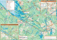
Southern area<br />
Inverbervie<br />
Johnshaven<br />
Montrose<br />
S<strong>to</strong>nehaven<br />
Miles<br />
0<br />
5 10 15<br />
Dunkeld<br />
Birnam<br />
0 5 10 15 20 25<br />
Kilometres<br />
Dundee<br />
Broughty Ferry<br />
Carnoustie<br />
Arbroath<br />
Pitcairngreen<br />
Invergowrie<br />
<strong>Firth</strong> <strong>of</strong><br />
<strong>Tay</strong><br />
<strong>Tay</strong>port<br />
Perth<br />
Newburgh<br />
Falkland<br />
St Andrews<br />
Map and text © <strong>Sustrans</strong> 2009<br />
Maps are reproduced from Ordnance<br />
Survey material with the permission <strong>of</strong><br />
Ordnance Survey on behalf <strong>of</strong> the Con<strong>to</strong>ller<br />
<strong>of</strong> Her Majesty’s Stationery Office © Crown<br />
copyright. Unauthorised reproduction<br />
infringes Crown copyright and may lead <strong>to</strong><br />
prosecution or civil proceedings.<br />
Licence number 100020852<br />
3<br />
4
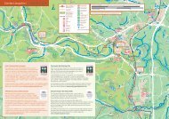
St Andrews <strong>to</strong> <strong>Tay</strong>port 1<br />
Map 2<br />
B946<br />
<strong>Tay</strong> Road Bridge<br />
Newpor<strong>to</strong>n-<strong>Tay</strong><br />
A92<br />
B946<br />
A914<br />
<strong>Tay</strong>port<br />
B945<br />
St Michael’s<br />
Wood<br />
Start/<br />
Finish<br />
Mor<strong>to</strong>n<br />
Lochs<br />
Tentsmuir Point National<br />
Nature Reserve<br />
(Scottish Natural Heritage)<br />
Tentsmuir Forest<br />
Kinshaldy<br />
Tentsmuir Point<br />
Category: Coastal<br />
Distance: 14 miles/22 kilometres<br />
(8 miles/13km traffic-free)<br />
Time: 2 hours<br />
Gradient: Flat<br />
Surface: Tarmac, public road and forest track<br />
This ride <strong>to</strong> the <strong>Firth</strong> <strong>of</strong> <strong>Tay</strong> starts from the ancient<br />
university <strong>to</strong>wn <strong>of</strong> St Andrews. Following National<br />
Route 1 signs northbound, cycle by the <strong>to</strong>wn’s<br />
West Sands and famous golf course <strong>to</strong> join a<br />
pleasant cycleway by the A91.<br />
After Guardbridge, quiet roads lead <strong>to</strong> Leuchars<br />
(station) and on <strong>to</strong> Tentsmuir Forest. This large<br />
area <strong>of</strong> Scots and Corsican Pine fronts the golden<br />
Tentsmuir Sands. Wildlife includes seals, huge<br />
flocks <strong>of</strong> eider duck in summer, and, more recently,<br />
the reintroduced sea eagle.<br />
A919<br />
Leuchars Station<br />
Leuchars<br />
Reres Wood<br />
From the entrance <strong>to</strong> Kinshaldy car park, go left for<br />
a family-friendly cycle ride through the forest. After<br />
1.5 miles look out for an old icehouse, where you<br />
can easily access the beach before the final ride <strong>to</strong><br />
<strong>Tay</strong>port and its attractive habour. See the leaflets<br />
produced by Fife Council on the Kingdom <strong>of</strong> Fife<br />
Cycleways for more information on cycle routes in<br />
the area.<br />
A914<br />
Guardbridge<br />
Miles<br />
0 1 2<br />
A91<br />
0 1 2 3<br />
Kilometres<br />
Kincaple<br />
A91<br />
St Andrews<br />
University <strong>of</strong> St Andrews Museum<br />
Collections (Museums Galleries Scotland)<br />
St Andrews Castle<br />
5<br />
Kemback<br />
Wood<br />
Kemback<br />
To<br />
Falkland<br />
Strathkinness<br />
B939<br />
A915<br />
Start/<br />
Finish<br />
B9131<br />
Cathedral<br />
Proposed route<br />
<strong>to</strong> East Neuk<br />
A917<br />
6
<strong>Tay</strong>port <strong>to</strong> Invergowrie 2<br />
Category: Coastal cycle path<br />
Distance: 7 miles/11 kilometres<br />
Time: 1 hour<br />
Gradient: Flat<br />
Surface: Tarmac<br />
Explore the banks <strong>of</strong> the <strong>Tay</strong>, Scotland’s longest river, on<br />
this satisfying and straightforward ride. The route starts from<br />
<strong>Tay</strong>port, on the south side <strong>of</strong> the <strong>Firth</strong>, and follows a former<br />
railway line before crossing the 1.5 mile-long <strong>Tay</strong> Road Bridge<br />
(look out for the track <strong>to</strong> the left that leads up <strong>to</strong> the bridge).<br />
On the far side, turn left <strong>to</strong> join National Route 77. This soon<br />
passes by the impressive RRS Discovery – Captain Scott’s polar<br />
expedition ship. The 100-year-old vessel has been lovingly<br />
res<strong>to</strong>red and a visit will appeal <strong>to</strong> young and old. You can<br />
continue on your own voyage <strong>of</strong> discovery on the cycle path by<br />
the shore road all the way <strong>to</strong> Invergowrie.<br />
Turning right from the <strong>Tay</strong> Road Bridge, Route 1 heads through<br />
the docks and, after a short stretch <strong>of</strong> quiet road, on<strong>to</strong> a fine<br />
cycle path along the coast <strong>to</strong> Broughty Ferry with its castle and<br />
beach. You may be asked for pho<strong>to</strong> ID at the docks security<br />
gates. If you are unable <strong>to</strong> get through, use the A82 for under a<br />
mile <strong>to</strong> Stannergate roundabout and turn right <strong>to</strong> rejoin the cycle<br />
path. There is a footway on the south side <strong>of</strong> the A82.<br />
Famous Dundonians © Fergal MacErlean<br />
Miles<br />
0 1<br />
0<br />
Kilometres<br />
1 2<br />
3<br />
2<br />
Camperdown<br />
Country Park<br />
A90<br />
Dundee Green Circular<br />
Dundee Circular – this cycle path<br />
(on- and <strong>of</strong>f-road sections) can be<br />
followed right round the city<br />
A90<br />
Caird<br />
Park<br />
Map 3<br />
Lochee<br />
A 923<br />
McManus Galleries<br />
(Dundee City Council)<br />
Dundee<br />
A929<br />
A972<br />
B959<br />
West Ferry<br />
Claypotts Castle<br />
(His<strong>to</strong>ric Scotland)<br />
A930<br />
Broughty<br />
Ferry Station<br />
Start/<br />
Finish<br />
Invergowrie<br />
Mills Observa<strong>to</strong>ry<br />
Verdant Works<br />
(Dundee Heritage<br />
Trust)<br />
Dundee Station<br />
A92<br />
Docks<br />
Pho<strong>to</strong> ID may be required<br />
Frigate Unicorn<br />
Broughty<br />
Ferry<br />
To Perth<br />
7<br />
<strong>Firth</strong> <strong>of</strong> <strong>Tay</strong><br />
A85<br />
<strong>Tay</strong> Rail Bridge<br />
<strong>Tay</strong> Road Bridge<br />
Royal Research Ship Discovery<br />
(Dundee Heritage Trust)<br />
Newpor<strong>to</strong>n-<strong>Tay</strong><br />
Map 1<br />
B946<br />
<strong>Tay</strong>port<br />
Start/<br />
Finish<br />
8
Broughty Ferry <strong>to</strong> Arbroath 3<br />
To<br />
Aberdeen<br />
St Vigeans<br />
Sculptured S<strong>to</strong>nes<br />
(His<strong>to</strong>ric Scotland)<br />
Arbirlot<br />
Start/<br />
Finish<br />
A933<br />
Hospitalfield House<br />
Arbroath<br />
Abby<br />
Arbroath<br />
Station<br />
Arbroath<br />
Signal Tower<br />
Museum<br />
A92<br />
Views <strong>of</strong> the North Sea from Broughty Ferry © Fergal MacErlean<br />
Hat<strong>to</strong>n<br />
A92 Cycleway<br />
A92<br />
A930<br />
East Haven<br />
Miles<br />
0 1<br />
2<br />
Map 2<br />
Ardestie Earth House<br />
(His<strong>to</strong>ric Scotland)<br />
Barry Water Mill<br />
(National Trust<br />
for Scotland)<br />
Carnoustie<br />
Carnoustie Station<br />
Golf Street Station<br />
Cycleway <strong>to</strong> be<br />
completed summer 2009<br />
0 1 2<br />
Kilometres<br />
3<br />
Broughty<br />
Ferry Station<br />
Broughty<br />
Ferry<br />
Dismantled<br />
railway<br />
Barnhill<br />
Balmossie<br />
Station<br />
Broughty<br />
Castle<br />
A92<br />
Monifieth<br />
Monifieth<br />
Station<br />
Start/<br />
Finish<br />
B962<br />
<strong>Firth</strong> <strong>of</strong> <strong>Tay</strong><br />
A930<br />
Barry Links<br />
Station<br />
Barry Links<br />
Buddon Ness<br />
Category: Coastal<br />
Distance: 14 miles/23 kilometres<br />
Time: 2 hours<br />
Gradient: Flat<br />
Surface: Tarmac<br />
Enjoy the sea air and views <strong>of</strong> golden sands on this excellent<br />
coastal route. Start at Broughty Castle. Built late in the 15th<br />
century <strong>to</strong> defend Dundee from attack, it was in military use<br />
until the 1930s. It is now a museum (free entry).<br />
Mor<strong>to</strong>n<br />
Lochs<br />
Tentsmuir Point National<br />
Nature Reserve<br />
(Scottish Natural Heritage)<br />
Tentsmuir Forest<br />
Tentsmuir Point<br />
From Monifieth, a fine cycle track heads over Barry Links,<br />
which is a wildlife haven. Further on, Carnoustie <strong>of</strong>fers<br />
opportunities for refreshments and a view <strong>of</strong> the famous<br />
championship golf course. A new cycle track from<br />
Carnoustie <strong>to</strong> East Haven will be completed in summer 2009.<br />
From there, the route continues inland on minor roads and on<br />
a cycleway alongside the A92 <strong>to</strong> the fishing <strong>to</strong>wn <strong>of</strong> Arbroath,<br />
famous for its ‘Smokies’.<br />
For a circular ride you can return <strong>to</strong>wards Dundee on the A92<br />
cycleway, crossing the Dighty Burn on the old railway back <strong>to</strong><br />
Broughty Ferry.<br />
9<br />
Map 1<br />
10
Perth <strong>to</strong> Pitcairngreen 4<br />
To Dunkeld<br />
A9<br />
Pitcairngreen<br />
River <strong>Tay</strong><br />
Start/<br />
Finish<br />
Scone Palace<br />
(His<strong>to</strong>ric Houses Association)<br />
Old Scone<br />
Almondbank<br />
The<br />
Woody<br />
Islands<br />
A93<br />
Hunting<strong>to</strong>wer<br />
Haugh<br />
Hotel<br />
Miles<br />
0 0.5 1<br />
0 0.5 1 1.5<br />
Kilometres<br />
Ruthvenfield<br />
Hunting<strong>to</strong>wer Castle<br />
(His<strong>to</strong>ric Scotland)<br />
A9<br />
Tulloch<br />
The Lade<br />
Perth<br />
A912<br />
A85<br />
Muir<strong>to</strong>n<br />
Black Watch<br />
Regimental Museum<br />
(Museums<br />
Galleries Scotland)<br />
North<br />
Inch<br />
Connect 2 Project.<br />
Proposed pedestrian<br />
and cycle bridge<br />
Quarrymill<br />
Start/<br />
Finish<br />
A94<br />
To Dundee<br />
Category: Riverside cycle path<br />
Distance: 6 miles/10 kilometres<br />
Time: 50 minutes<br />
Gradient: Flat, excepting the final steep climb <strong>to</strong> Pitcairngreen<br />
Surface: Tarmac and dust<br />
Looking for a flat cycle and a pretty riverside setting? This route<br />
from Perth is perfect for all the family. Within minutes <strong>of</strong> starting<br />
you’ll be cycling alongside the River <strong>Tay</strong> with views <strong>of</strong> Scone<br />
Palace where Scotland’s kings <strong>of</strong> old were crowned. Take a<br />
picnic and enjoy the scenery.<br />
Further on, the route follows a track by the River Almond,<br />
passing close <strong>to</strong> the atmospheric, medieval Hunting<strong>to</strong>wer Castle.<br />
After Almondbank the route joins a road, which can be busy, for<br />
the final climb <strong>to</strong> the attractive planned village <strong>of</strong> Pitcairngreen<br />
where there’s a welcoming pub.<br />
Cherry Bank<br />
Gardens<br />
A98<br />
Perth<br />
Perth Museum and<br />
Art Gallery (Museums<br />
Galleries Scotland)<br />
Fergusson Gallery<br />
(Museums Galleries<br />
Scotland)<br />
South<br />
Inch<br />
A912<br />
Branklyn Garden<br />
(National Trust<br />
for Scotland)<br />
11<br />
12
Birnam Dunkeld Cycle 5<br />
Miles<br />
0 0.5<br />
1<br />
B898<br />
Category: Riverside cycle path<br />
Distance: 3 miles/5 kilometres<br />
Time: 30 minutes<br />
Gradient: Flat<br />
Surface: Forest track and dust<br />
0<br />
Kilometres<br />
0.5 1<br />
1.5<br />
To<br />
Pitlochry<br />
Start/<br />
Finish<br />
A923<br />
Loch <strong>of</strong> the Lowes Visi<strong>to</strong>r<br />
Centre (Scottish Wildlife Trust)<br />
King’s<br />
Seat<br />
Hotel<br />
Dunkeld (National<br />
Trust for Scotland)<br />
Abbey<br />
Dunkeld<br />
Chapter House Museum<br />
(Museums Galleries Scotland)<br />
A9<br />
Inver<br />
This route leads through some very scenic and interesting parts<br />
The Hermitage<br />
<strong>of</strong> Highland (National Trust Perthshire. Beatrix Potter fans should make a short<br />
de<strong>to</strong>ur for in Scotland) Birnam <strong>to</strong> visit The Beatrix Potter Centre and Garden;<br />
the imaginative author spent childhood summers in the area.<br />
Cross the <strong>Tay</strong>, on Telford’s famous bridge, <strong>to</strong> enter adjoining<br />
Dunkeld. Once a significant Pictish centre, it is now a bustling<br />
and prosperous <strong>to</strong>wn Dundonnachie<br />
with several good eateries. Continue up the<br />
main street and turn left in<strong>to</strong> the grounds <strong>of</strong> the Hil<strong>to</strong>n Dunkeld<br />
House Hotel <strong>to</strong> join a track that leads along the tree-lined river<br />
banks. Further on, the track loops up and over the river and<br />
railway giving fine views <strong>of</strong> the river valley. Continue on minor<br />
roads <strong>to</strong> Pitlochry or retrace your outward route.<br />
A882<br />
Heading south from Birnam, an underpass under the A9 leads<br />
past the train station and on<strong>to</strong> a cycleway alongside the A9.<br />
Route 77 then follows minor roads for 10 miles <strong>to</strong> Pitcairngreen<br />
(see Map 4).<br />
Dunkeld &<br />
Birnam Station<br />
Start/<br />
Finish<br />
Beatrix Potter<br />
Garden & Birnam<br />
Institute<br />
A9<br />
River <strong>Tay</strong><br />
A984<br />
Birnam<br />
To Perth<br />
13 & Pitcairngreen<br />
14
Johnshaven <strong>to</strong> Inverbervie 6<br />
To Aberdeen<br />
Inverbervie<br />
Start/<br />
Finish<br />
Bervie Bay from National Route 1 © Fergal MacErlean<br />
Gourdon<br />
Lifeboat<br />
Museum<br />
Nether<br />
Knox<br />
A92<br />
Miles<br />
0 0.5<br />
0 1.5 1<br />
Kilometres<br />
1.5<br />
1<br />
Narrows<br />
15<br />
Johnshaven<br />
To Arbroath &<br />
Dundee<br />
Mains <strong>of</strong><br />
Brother<strong>to</strong>n<br />
A92<br />
Benholm<br />
Start/<br />
Finish<br />
Haugh <strong>of</strong><br />
Benholm<br />
Category: Coastal <strong>of</strong>f-road cyclepath<br />
Distance: 4.5 miles/7 kilometres<br />
Time: 1 hour<br />
Gradient: Undulating<br />
Surface: Rough s<strong>to</strong>ny track, farm road<br />
With uninterrupted North Sea views this is a great route<br />
on a sunny summer’s day. However, as the coastal path<br />
is rough in places, it is not recommended for narrowtyred<br />
bikes or laden <strong>to</strong>urers. Join the <strong>of</strong>f-road path at<br />
the edge <strong>of</strong> Johnshaven, just past a campsite.<br />
The east coast village once had a thriving port, which<br />
during the 18th century was one <strong>of</strong> the largest in<br />
Scotland. Although few inhabitants make a living from<br />
the sea, nowadays they have a lot <strong>of</strong> pride in their<br />
sea-faring heritage. Enjoy the peaceful location and<br />
bird spotting opportunities. Gourdon has several pubs<br />
and cafés where you can catch your breath before<br />
returning <strong>to</strong> Johnshaven or continuing on the <strong>of</strong>f-road<br />
path <strong>to</strong> Inverbervie.<br />
Between Gourdon and Inverbervie the route follows the<br />
line <strong>of</strong> the disused railway, which is now a rather<br />
potholed farm road, but <strong>of</strong>fers great sea views.<br />
Aberdeenshire Council plans <strong>to</strong> upgrade this section in<br />
2009.<br />
16
Northern area<br />
Miles<br />
0<br />
5 10 15<br />
0 5 10 15 20 25<br />
Kilometres<br />
Findochty<br />
Buckie<br />
Portknockie<br />
Cullen<br />
Portsoy<br />
Whitehills<br />
Fraserburgh<br />
Garmouth<br />
Banff<br />
Macduff<br />
The 6000 km North Sea Cycle Route<br />
is the world’s longest signed<br />
international cycle route, passing<br />
through 8 countries around the<br />
North Sea. It mainly follows Route 1<br />
<strong>of</strong> the National Cycle Network up the east coast<br />
<strong>of</strong> the UK. www.northsea-cycle.com<br />
Maud<br />
Mintlaw<br />
Peterhead<br />
Deeside Way<br />
Dyce <strong>to</strong> Newmachar<br />
The Formartine & Buchan Way<br />
Banff <strong>to</strong> Whitehills<br />
Cullen <strong>to</strong> Buckie<br />
Buckie <strong>to</strong> Garmouth<br />
p20<br />
p22<br />
p24<br />
p26<br />
p28<br />
p28<br />
Ellon<br />
On-road National Cycle Network section<br />
Traffic-free National Cycle Network section<br />
Other routes<br />
Time: The time given <strong>to</strong> complete a route is<br />
calculated on an average travelling time <strong>of</strong> 7 miles<br />
or 11 km per hour. This allows for a leisurely cycling<br />
pace or for plenty <strong>of</strong> s<strong>to</strong>ps. Times and distances<br />
given for linear routes are for one way only.<br />
Newmachar<br />
Aberdeen<br />
Ballater<br />
17<br />
Deeside Way<br />
18
Deeside Way section 7<br />
Miles<br />
0<br />
1 2<br />
Aberdeen Station<br />
0<br />
Kilometres<br />
1 2<br />
3<br />
A90<br />
Mann<strong>of</strong>ield<br />
Aberdeen<br />
A9013<br />
A945<br />
Dunthie<br />
Park<br />
Start/<br />
Finish<br />
A93<br />
B9077<br />
Cults<br />
Kaimhill<br />
Kincorth<br />
Bieldside<br />
Peterculter<br />
St Peter's<br />
Heritage Centre<br />
(Museums Galleries<br />
Scotland)<br />
Milltimber<br />
B979<br />
A93<br />
New<strong>to</strong>n<br />
Dee<br />
River Dee<br />
The Blairs Museum<br />
(Museums Galleries Scotland)<br />
B9077<br />
Banchory-Devenick<br />
Category: Railway path<br />
Distance: 6.5 miles/11 kilometres<br />
Time: 1 hour<br />
Gradient: Flat<br />
Surface: First 2.5 miles tarmac then dust<br />
To Banchory<br />
& Ballater<br />
Start/<br />
Finish<br />
The Deeside Way in Aberdeen<br />
S<strong>to</strong>rybook Glen<br />
The Deeside Way will eventually run for 42 miles between<br />
Aberdeen and Ballater in Royal Deeside. It mainly follows the<br />
disused railway line (16 miles from Aberdeen <strong>to</strong> Banchory and 11<br />
miles from Aboyne <strong>to</strong> Ballater) and is suitable for cyclists <strong>of</strong> all<br />
abilities and is especially good for families. Between Banchory<br />
and Aboyne, where the original railway <strong>to</strong>ok a long loop<br />
northwards via Torphins, the cycle route will follow a more direct<br />
mixture <strong>of</strong> minor roads and forest tracks – a little more difficult <strong>to</strong><br />
navigate, but still very family-friendly. This section is scheduled<br />
<strong>to</strong> be completed in 2010/11.<br />
The highlighted route follows the start <strong>of</strong> the Deeside Way from<br />
the north gate <strong>of</strong> Aberdeen’s Duthie Park <strong>to</strong> Peterculter. Along<br />
the way there is information about all the former railway stations<br />
that existed until 1966 and fine views <strong>of</strong> the River Dee through<br />
the trees.<br />
The original plan in the 1840s was for the line <strong>to</strong> continue west<br />
from Ballater <strong>to</strong> Braemar, but Queen Vic<strong>to</strong>ria insisted it terminate<br />
well away from her Balmoral residence. As it travels up beautiful<br />
Royal Deeside, the Way passes by many places <strong>of</strong> interest,<br />
including Crathes and Drum castles, a recreated steam railway<br />
at Crathes, Aboyne Gliding Club and the Cambus O’ May<br />
suspension bridge. At Ballater, the former railway station is<br />
recreated and also houses the <strong>to</strong>urist information centre.<br />
19<br />
20
Westside<br />
Map 9<br />
West-<strong>to</strong>wn<br />
Dyce <strong>to</strong> Newmachar 8<br />
Newmachar<br />
B979<br />
Start/<br />
Finish<br />
Lower Rannieshill<br />
B979<br />
Standryford<br />
Kinmundy<br />
Category: Railway path<br />
Distance: 6 miles/10 kilometres<br />
Time: 50 minutes<br />
Gradient: Flat<br />
Surface: Whin dust<br />
Join the Formartine and Buchan Way way from Dyce railway<br />
station car park (signed). The cycleway follows the line <strong>of</strong> the<br />
disused railway all the way <strong>to</strong> Newmachar. Be aware that there<br />
are a few minor road crossings where the railway bridges have<br />
been removed. That aside, this is a route where you can really<br />
enjoy effortless cycling along this flat, traffic-free route.<br />
It’s particularly attractive in the spring and summer months when<br />
the hedgerows come alive. Rich farmland, for which this part <strong>of</strong><br />
the north-east is famed, extends on both sides. A short trip on a<br />
minor road takes you in<strong>to</strong> the <strong>to</strong>wn <strong>of</strong> Newmachar where you can<br />
eat and drink before returning by the same route, or continue <strong>to</strong><br />
explore the Formartine and Buchan Way (see map 9 for details).<br />
A947<br />
Miles<br />
0 0.5 1<br />
Cothall<br />
B977<br />
0 0.5 1 1.5<br />
Kilometres<br />
Dyce Symbol<br />
S<strong>to</strong>nes<br />
(His<strong>to</strong>ric<br />
Scotland)<br />
B977<br />
River Don<br />
A947<br />
Dyce<br />
Dyce Station<br />
Aberdeen<br />
Airport<br />
Start/<br />
Finish<br />
To<br />
Aberdeen<br />
21<br />
Cyclists on the Formartine and Buchan Way<br />
© Aberdeenshire Council<br />
22
90<br />
A<br />
Fraserburgh Heritage Centre<br />
(Museums Galleries Scotland)<br />
Kinnaird Head Castle Lighthouse<br />
and Museum (His<strong>to</strong>ric Scotland)<br />
Museum <strong>of</strong> Scottish Lighthouses<br />
(Museums Galleries Scotland)<br />
Fraserburgh<br />
B9033<br />
Inverallochy<br />
The Formartine and Buchan Way 9<br />
Miles<br />
0 1 2 3<br />
A981<br />
Memsie Cairn<br />
(His<strong>to</strong>ric Scotland)<br />
Rathen<br />
St Combs<br />
North Sea<br />
0 1 2 3 4 5<br />
Kilometres<br />
A981<br />
B9093<br />
Strichen<br />
B9170<br />
A920<br />
A947<br />
Use the B9106 and A950<br />
in this section. Not suitable<br />
for inexperienced cyclists and<br />
young children<br />
B9170<br />
B9170<br />
Methlick<br />
Haddo House<br />
(National Trust<br />
for Scotland)<br />
Tarves<br />
B999<br />
Tolquhon<br />
Castle<br />
(His<strong>to</strong>ric<br />
Scotland)<br />
New<br />
Deer<br />
Udny<br />
Green<br />
A981<br />
B9029<br />
B9106<br />
Auchnagatt<br />
Ythanbank<br />
9005<br />
B<br />
Pitmedden Garden<br />
(National Trust<br />
for Scotland)<br />
Pitrmedeen<br />
A981<br />
A950<br />
Maud Railway Station<br />
Museum (Museums<br />
Galleries Scotland)<br />
A920<br />
Udny<br />
Station<br />
Maud<br />
A948<br />
B9000<br />
B9030<br />
A948<br />
B9093<br />
Fetterangus<br />
Aberdeenshire Farming<br />
Museum (Museums<br />
Galleries Scotland)<br />
Ellon<br />
A952<br />
Mintlaw Longside Peterhead<br />
Arbuthnot Museum<br />
Old Deer<br />
(Museums Galleries<br />
Scotland)<br />
A950<br />
A90<br />
Category: Railway path<br />
Distance: 54 miles/87 kilometres<br />
Gradient: Flat<br />
Surface: Dust<br />
The Formartine and Buchan Way is a 54 mile <strong>of</strong>f-road route,<br />
which runs from Dyce Railway Station in<strong>to</strong> the heart <strong>of</strong> rural<br />
Aberdeenshire, linking Ellon, Maud, and the coastal <strong>to</strong>wns <strong>of</strong><br />
Fraserburgh and Peterhead. The flat nature <strong>of</strong> the Way, makes it<br />
an ideal recreational route and, as it acts as a wildlife corridor,<br />
there is plenty <strong>to</strong> see throughout the year.<br />
From Dyce, the Way runs some 25 miles <strong>to</strong> Maud where it splits.<br />
Continuing north for 15 miles leads <strong>to</strong> Fraserburgh. (Note: the<br />
railway path is unsurfaced just north <strong>of</strong> Maud. Use public roads<br />
for two miles, rejoining the railway path at Bruckley Bridge on the<br />
A950.) The eastern branch can be followed for 13 miles <strong>to</strong><br />
Peterhead. The Way passes through (or near) many places <strong>of</strong><br />
interest, such as Aden Country Park, Drinnies Wood Observa<strong>to</strong>ry,<br />
Strichen S<strong>to</strong>ne Circle and Deer Abbey.<br />
There is an extensive network <strong>of</strong> minor roads in the area for<br />
circular rides in the area, such as Route 1 from Newmachar <strong>to</strong><br />
Auchnagatt.<br />
23<br />
B999<br />
Newmachar<br />
Map 8<br />
24
Banff <strong>to</strong> Whitehills 10<br />
Category: Coastal cycle path<br />
Distance: 2.5 miles/4 kilometres<br />
Time: 20 minutes<br />
Gradient: Undulating<br />
Surface: Tarmac and dust<br />
Have fun cycling by the <strong>Moray</strong> <strong>Firth</strong>! From Meavie Point in<br />
Banff, head east along the coast on a quiet road which joins a<br />
cyclepath <strong>to</strong> Banff Links. The route leads through a caravan<br />
park/campsite, across a footbridge and on tracks round the<br />
coast <strong>to</strong> Whitehills. En route there are great sea views and the<br />
Roman built Red Well. In Whitehills, look out for the excellent fish<br />
shop by the harbour.<br />
Another route from Banff is <strong>to</strong> follow the rough tracks around<br />
Montc<strong>of</strong>fer Woods. Start or finish at Duff House – a Country<br />
House Gallery <strong>of</strong> the National Galleries <strong>of</strong> Scotland, which has<br />
works by El Greco, among other luminaries, and visiting<br />
exhibitions. A highlight <strong>of</strong> this cycle route is the picturesque<br />
Bridge <strong>of</strong> Alvah.<br />
Duff House<br />
Start/<br />
Finish<br />
North Sea<br />
Miles<br />
0 0.5<br />
1<br />
Whitehills<br />
To Inverness<br />
B9038<br />
Start/<br />
Finish<br />
0 0.5 1<br />
Kilometres<br />
1.5<br />
B9139<br />
Inverboyndie<br />
A98<br />
Banff<br />
A98<br />
Banff Museum<br />
(Museums Galleries<br />
Scotland)<br />
Macduff<br />
A97<br />
Duff House<br />
(Museums<br />
Galleries<br />
Scotland)<br />
Distillery<br />
A947<br />
B9121<br />
Montc<strong>of</strong>fer<br />
Woods<br />
Mains <strong>of</strong><br />
25 Montc<strong>of</strong>fer<br />
26<br />
Bridge <strong>of</strong> Alvah<br />
To Aberdeen
Cullen <strong>to</strong> Buckie 11a<br />
Miles<br />
0<br />
0<br />
Kilometres<br />
1<br />
1<br />
2<br />
2<br />
3<br />
Findochty<br />
Portknockie<br />
Bow Fiddle Rock<br />
Category: Coastal and railwaypath<br />
Distance: 7 miles<br />
11 kilometres<br />
Time: 1 hour<br />
Gradient: Flat<br />
Surface: Tarmac, dust<br />
A942<br />
Portessie<br />
Route<br />
continues<br />
below<br />
Buckie<br />
Spey Bay<br />
(Scottish Wildlife Trust)<br />
Kings<strong>to</strong>n<br />
To Inverness<br />
Rathven<br />
A98<br />
Spey Bay<br />
Wildlife Centre<br />
A942<br />
From the north end <strong>of</strong><br />
Cullen’s North Deskford<br />
Street join National<br />
Route 1 <strong>to</strong> cycle along<br />
an old railway line and<br />
over two spectacular<br />
viaducts. The route runs<br />
along the coast <strong>to</strong> give<br />
National Route 1 can be<br />
followed easily from<br />
Buckie <strong>to</strong> Garmouth.<br />
The A-road is followed<br />
out <strong>of</strong> Buckie before the<br />
route rejoins the railway<br />
track <strong>to</strong> Portgordon.<br />
Further on, after minor<br />
Spey Bay<br />
A942<br />
glorious sea views. At<br />
Portknockie, a short<br />
de<strong>to</strong>ur takes you <strong>to</strong> the<br />
surreal looking Bow<br />
Fiddle Rock. After a<br />
short stretch along the<br />
quiet streets <strong>of</strong><br />
Portknockie, the route<br />
A98<br />
roads, the route follows a<br />
final section <strong>of</strong> railway path,<br />
crossing the mighty Spey<br />
Bay Viaduct in<strong>to</strong> Garmouth.<br />
From here it’s one mile <strong>to</strong><br />
the lovely village <strong>of</strong><br />
Kings<strong>to</strong>n-on-Spey and its<br />
long shingle beach. Another<br />
Start/<br />
Finish<br />
rejoins the railway path<br />
<strong>to</strong> follow the coast <strong>to</strong><br />
Findochty (pronounced<br />
Finechty). To continue<br />
west, cross over the<br />
A942 <strong>to</strong> follow the<br />
railway path for 2.5<br />
miles in<strong>to</strong> Buckie.<br />
A990<br />
Cullen<br />
To Aberdeen<br />
Buckie <strong>to</strong> Garmouth11b<br />
recommended de<strong>to</strong>ur is <strong>to</strong><br />
the Tugnet Ice House and<br />
<strong>Moray</strong> <strong>Firth</strong> Wildlife Centre<br />
at Spey Bay. (From<br />
Portgordon you can also<br />
follow the <strong>of</strong>f-road<br />
Speyside Way via<br />
Auchenreath).<br />
Buckie<br />
Garmouth<br />
Speyside Way<br />
Route<br />
continues<br />
27<br />
Start/<br />
Finish<br />
B9015<br />
Speyside Speyside Way<br />
Way<br />
B9104<br />
B9104<br />
Bogmoor<br />
Nether<br />
Dallachy<br />
Upper<br />
Dallachy<br />
Lower<br />
Auchenreath<br />
A990<br />
A990<br />
Portgordon<br />
Category: Railway path, minor road, short<br />
A-road section<br />
Distance:<br />
Time:<br />
Gradient:<br />
Surface:<br />
7 miles/11kilometres<br />
1 hour<br />
Flat<br />
Tarmac, dust<br />
A98<br />
28
Northumberland<br />
National Cycle Network in Scotland<br />
From gentle rides along old railway lines, canal<br />
<strong>to</strong>wpaths and quiet country routes over moorland,<br />
mountain and forest terrain, cycling in Scotland<br />
has something for everyone.<br />
This map shows the National Cycle Network<br />
routes in Scotland. You may want <strong>to</strong> cycle part <strong>of</strong><br />
them as a day trip or enjoy a longer cycle.<br />
Stromness<br />
1<br />
Kirkwall<br />
SHETLAND ISLANDS<br />
1<br />
Unst<br />
See page 34 for a list <strong>of</strong> maps and guides<br />
available from <strong>Sustrans</strong>.<br />
1<br />
Thurso<br />
John o'Groats<br />
1<br />
Lerwick<br />
Tongue<br />
Sumburgh<br />
1<br />
Lairg<br />
Tain<br />
Cullen<br />
Cromarty<br />
Nairn<br />
Forres<br />
Elgin<br />
Buckie<br />
Banff<br />
Inverness<br />
Turriff<br />
Maud<br />
7<br />
79<br />
78<br />
Carrbridge<br />
1<br />
Lochboisdale<br />
Broadford<br />
Glenelg<br />
Loch Ness<br />
Aviemore<br />
Dyce<br />
Castlebay<br />
79<br />
Invergarry<br />
Fort Augustus<br />
Kingussie<br />
New<strong>to</strong>nmore<br />
Cairngorms National Park<br />
195<br />
Aberdeen<br />
Loch Lochy<br />
S<strong>to</strong>nehaven<br />
78<br />
Fort William<br />
7<br />
Blair Atholl<br />
Pitlochry<br />
Montrose<br />
Aberfeldy<br />
Dunkeld<br />
7<br />
Arbroath<br />
Killin<br />
77<br />
Dundee<br />
<strong>Tay</strong>nuilt<br />
Carnoustie<br />
Loch Lomond<br />
Monifieth<br />
Oban<br />
& The Trossachs<br />
775<br />
On-road section<br />
Perth<br />
777<br />
Leuchars<br />
78<br />
National Park<br />
St Andrews<br />
775<br />
777<br />
776<br />
Traffic-free sections<br />
Callander<br />
1<br />
Tarbet<br />
765<br />
1<br />
76<br />
Aberfoyle<br />
Proposed routes<br />
Glenrothes<br />
Alloa<br />
766<br />
Colonsay<br />
Crinan<br />
40<br />
7<br />
Stirling<br />
764<br />
Dunfermline<br />
Selected regional routes<br />
Kirkcaldy<br />
75<br />
Larbert /<br />
76<br />
Kirkintilloch<br />
Stenhousemuir<br />
/ Lenzie<br />
Towns with railway stations<br />
Edinburgh<br />
Dumbar<strong>to</strong>n<br />
754<br />
Clydebank<br />
Greenock<br />
75<br />
Bathgate 75<br />
Musselburgh<br />
76<br />
Tarbert<br />
Glasgow<br />
Towns without railways stations<br />
Kilmacolm<br />
78<br />
Paisley<br />
East End<br />
73<br />
Lochwinnoch<br />
Airdrie<br />
Livings<strong>to</strong>n Balerno Dalkeith<br />
Claonaig<br />
1 National Cycle Network route number<br />
Kennacraig<br />
Barrhead<br />
Hamil<strong>to</strong>n<br />
Penicuik<br />
Lochranza<br />
7<br />
Berwick-upon-Tweed<br />
Port<br />
Ellen<br />
74<br />
Kilwinning<br />
Carstairs Junction<br />
10 Regional route number<br />
Ardrossan<br />
73<br />
Irvine<br />
82<br />
78<br />
Kilmarnock<br />
Galashiels<br />
73<br />
1<br />
Bamburgh<br />
Brodick<br />
Troon<br />
Melrose<br />
Wooler<br />
68<br />
Abing<strong>to</strong>n<br />
Malin Head<br />
Ayr<br />
Harwick<br />
Campbel<strong>to</strong>wn<br />
Northumberland<br />
1<br />
Rathlin Island<br />
Maybole<br />
Carndonagh<br />
Portrush<br />
Ballycastle<br />
74<br />
Magilligan<br />
Greencastle<br />
Amble<br />
Point<br />
Buncrana<br />
7<br />
Bushmills<br />
Creeslough<br />
Coleraine<br />
93<br />
Ashing<strong>to</strong>n<br />
Cushendun<br />
Castlerock<br />
68<br />
Limavady Ballymoney<br />
Bur<strong>to</strong>nport<br />
Cushendall<br />
Bellingham<br />
Derry/<br />
Lockerbie<br />
96<br />
Blyth<br />
Londonderry<br />
The Glens<br />
92 93<br />
<strong>of</strong> Antrim<br />
Dumfries<br />
10 Cramling<strong>to</strong>n<br />
Letterkenny<br />
7<br />
Gretna<br />
Claudy<br />
Glenarm<br />
10<br />
Raphoe<br />
Cairnryan<br />
7<br />
72<br />
Tynemouth<br />
Annan<br />
Newcastle<br />
97<br />
Corbridge<br />
South Shields<br />
Portglenone<br />
New<strong>to</strong>n Stewart<br />
Sperrins<br />
72<br />
Strabane<br />
Stranraer<br />
Castle Douglas<br />
Hexham<br />
Ballymena<br />
Gatehouse<br />
Haltwhistle<br />
Larne<br />
<strong>of</strong> Fleet<br />
Gateshead<br />
14<br />
Sunderland<br />
73<br />
Silloth<br />
10 Carlisle Bramp<strong>to</strong>n<br />
68<br />
New<strong>to</strong>wnstewart<br />
Gortin<br />
Toome<br />
Consett<br />
93<br />
Washing<strong>to</strong>n<br />
72<br />
Als<strong>to</strong>n 7<br />
Seaham<br />
95<br />
95<br />
Antrim<br />
Donegal<br />
Carrickfergus<br />
7<br />
Durham<br />
14<br />
Pettigoe<br />
94<br />
10<br />
Ballyshannon<br />
Omagh<br />
Cooks<strong>to</strong>wn<br />
Lough<br />
94<br />
Whiteabbey<br />
Bangor<br />
Maryport<br />
Wingate<br />
14<br />
Neagh<br />
Bundoran<br />
New<strong>to</strong>wnards<br />
Cockermouth<br />
68<br />
1<br />
Hartlepool<br />
Belfast<br />
29 91<br />
92<br />
Working<strong>to</strong>n<br />
72<br />
20 S<strong>to</strong>ck<strong>to</strong>n<br />
Redcar<br />
30<br />
Belleek<br />
Fin<strong>to</strong>na<br />
Penrith<br />
Lisburn<br />
Whitehaven<br />
-on-<br />
Dungannon<br />
Comber<br />
Lower<br />
Lagan Valley<br />
71 Keswick<br />
Tees<br />
94<br />
Appleby<br />
1
Support <strong>Sustrans</strong> <strong>to</strong>day<br />
<strong>Sustrans</strong> is the UK’s leading<br />
sustainable transport charity.<br />
Our vision is a world in which people choose <strong>to</strong> travel in ways<br />
that benefit their health and the environment. We work on<br />
practical, innovative solutions <strong>to</strong> the transport challenges facing<br />
us all. <strong>Sustrans</strong> is the charity behind the award winning National<br />
Cycle Network, Safe Routes <strong>to</strong> Schools, Bike It, TravelSmart,<br />
Active Travel, Connect2 and Liveable Neighbourhoods, all<br />
projects that are changing our world one mile at a time.<br />
Support <strong>Sustrans</strong>.<br />
Join the movement.<br />
For more information on the National Cycle Network, <strong>to</strong> buy<br />
maps and guides or <strong>to</strong> find out more about <strong>Sustrans</strong>,<br />
visit www.sustrans.org.uk or call 0845 113 00 65<br />
If you think what we do sounds sensible, we urgently need<br />
people like you <strong>to</strong> help us do more. By giving from £5 a month<br />
you’ll start <strong>to</strong> make a difference. Without this financial support,<br />
<strong>Sustrans</strong> and projects such as the National Cycle Network would<br />
probably not exist.<br />
To become a <strong>Sustrans</strong> Supporter <strong>to</strong>day please complete the<br />
form on the opposite page and send it <strong>to</strong>:<br />
<strong>Sustrans</strong><br />
Freepost BS7739<br />
Bris<strong>to</strong>l<br />
BS1 5FA<br />
or phone 0845 838 0651<br />
Please complete this form and send it <strong>to</strong>:<br />
<strong>Sustrans</strong>, Freepost BS7739, Bris<strong>to</strong>l BS1 5FA.<br />
Alternatively, you can make a donation online by visiting<br />
www.sustrans.org.uk or over the phone on 0845 838 0651.<br />
First name<br />
Address<br />
Surname<br />
Postcode<br />
Telephone<br />
E-mail address<br />
Data protection: We promise that any information you give will<br />
be used by <strong>Sustrans</strong> only and not passed <strong>to</strong> any other<br />
organisation. If you would prefer us not <strong>to</strong> contact you about<br />
special appeals please tick here<br />
How <strong>to</strong> donate: Choose your preferred donation method and<br />
complete either section A or B and section C<br />
A<br />
YES<br />
I’ll join<br />
<strong>Sustrans</strong><br />
with a<br />
Direct Debit<br />
B<br />
YES<br />
I’ll join<br />
<strong>Sustrans</strong><br />
with a<br />
Donation<br />
Your monthly gift will provide us with vital<br />
regular income <strong>to</strong> help us develop the National<br />
Cycle Network and enable us <strong>to</strong> keep our<br />
administration costs <strong>to</strong> a minimum.<br />
(Please tick) £5 £10 £15 £ other<br />
Please complete the Direct Debit instructions<br />
overleaf.<br />
(Please tick) £20 £30 £50 £ other<br />
Please enclose a cheque/PO/Charity Voucher<br />
payable <strong>to</strong> <strong>Sustrans</strong> and send this form <strong>to</strong>:<br />
<strong>Sustrans</strong>, Freepost BS7739, Bris<strong>to</strong>l BS1 5FA<br />
Please send me a pack on leaving a legacy<br />
<strong>to</strong> <strong>Sustrans</strong><br />
If you’d like <strong>to</strong> help <strong>Sustrans</strong> in a hands-on way, why not<br />
become a volunteer ranger?<br />
As a <strong>Sustrans</strong> Volunteer Ranger you will help <strong>to</strong> look after and<br />
promote a section <strong>of</strong> the National Cycle Network near your<br />
home, and so encourage more people <strong>to</strong> cycle and walk.<br />
To find how <strong>to</strong> become a Volunteer Ranger visit<br />
www.sustrans.org.uk/rangers<br />
Registered Charity No. 326550 (England and Wales)<br />
SCO39263 (Scotland)<br />
31 32<br />
!<br />
C<br />
Gift Aid<br />
Make your<br />
support go<br />
further for free<br />
Make your support go further for free. Use Gift<br />
Aid and you can make your donation worth<br />
more. For every pound you give <strong>to</strong> us we get<br />
an extra 25 pence from the Inland Revenue.<br />
Simply tick the boxes below, it’s that simple.<br />
I am a UK taxpayer and want <strong>Sustrans</strong> <strong>to</strong><br />
treat all donations that I make from the date <strong>of</strong><br />
this declaration until I notify you otherwise as<br />
Gift Aid donations.<br />
I am a UK taxpayer and would like <strong>Sustrans</strong><br />
<strong>to</strong> Gift Aid all donations within the charity’s<br />
current financial period and the previous six<br />
years until I notify you otherwise.<br />
You will need <strong>to</strong> pay an amount <strong>of</strong> income tax and/or capital gains<br />
tax equal <strong>to</strong> the tax we claim on your donations (currently 25p for<br />
every £1 you give). Thank you.
Also available from <strong>Sustrans</strong><br />
Instruction <strong>to</strong> your Bank or Building Society <strong>to</strong> pay<br />
by Direct Debit<br />
Please fill in the whole form and send it <strong>to</strong>:<br />
<strong>Sustrans</strong>, Freepost BS7739, Bris<strong>to</strong>l, BS1 5FA<br />
Name and full postal address <strong>of</strong> your Bank or Building Society<br />
To: The Manager<br />
Address<br />
Name(s) <strong>of</strong> Account Holder(s)<br />
Bank/Building Society account number<br />
Branch sort code<br />
Origina<strong>to</strong>r’s indentification number<br />
6 7 2 6 7 7<br />
Reference number<br />
Bank/Building Society<br />
Instruction <strong>to</strong> your Bank or Building Society<br />
Please pay <strong>Sustrans</strong> Direct Debits from the account detailed in<br />
this instruction subject <strong>to</strong> the safeguards assured by the Direct<br />
Debit Guarantee. I understand that this instruction may remain<br />
with <strong>Sustrans</strong> and, if so, details will be passed electronically <strong>to</strong><br />
my Bank or Building Society.<br />
Signature(s)<br />
Date<br />
Postcode<br />
Banks and Building Societies may not accept Direct Debit instructions<br />
for some types <strong>of</strong> account.<br />
To order maps and guides for stunning cycling and walking<br />
routes throughout Scotland and the rest <strong>of</strong> the UK please call<br />
0845 113 00 65 or visit<br />
www.sustranshop.co.uk<br />
Lochs & Glens Pack<br />
Covering National Route 7<br />
between Inverness<br />
and Carlisle<br />
Code NNP01, £18.00<br />
Coast & Castles Pack<br />
Covering National Route 1<br />
between Newcastle<br />
and Aberdeen<br />
Code NNP04, £16.00<br />
National Cycle Network<br />
Maps for Scotland:<br />
Lochs & Glens South<br />
Carlisle <strong>to</strong> Glasgow via the Ayrshire coast<br />
Code NN7B, £6.99<br />
Lochs & Glens North<br />
Northern section <strong>of</strong> the Lochs and Glens cycle route between<br />
Glasgow and Inverness<br />
Code NN7C, £6.99<br />
Salmon Run<br />
Dundee <strong>to</strong> Perth and Pitlochry plus five circular rides in the<br />
<strong>Tay</strong> Valley<br />
Code NN77, £3.99<br />
Oban <strong>to</strong> Campbel<strong>to</strong>wn<br />
Code NN78, £3.99<br />
Aberdeen <strong>to</strong> John O’Groats<br />
Code NN1E, £2.99<br />
Forth & Clyde (2009 edition)<br />
Code NN75, £6.99<br />
Round the Forth (2008 edition)<br />
Code NN76, £6.99<br />
Coast & Castles South (2008 edition)<br />
Code NN1C, £6.99<br />
Coast and Castles North (2009 edition)<br />
Edinburgh <strong>to</strong> Aberdeen<br />
Code NN1D, £6.99<br />
Other booklets in this series:<br />
Edinburgh, Fife, Central and Borders<br />
Glasgow and Ayrshire<br />
The Central Highlands, Argyll and The Trossachs<br />
!<br />
33<br />
34
Area covered by this booklet<br />
Cullen<br />
Forres<br />
Elgin<br />
Buckie<br />
Banff<br />
Turriff<br />
Maud<br />
Dyce<br />
Aberdeen<br />
Ballater<br />
Cairngorms National Park<br />
Banchory<br />
S<strong>to</strong>nehaven<br />
Montrose<br />
Dunkeld<br />
Perth<br />
Dundee<br />
Leuchars<br />
Arbroath<br />
Carnoustie<br />
Monifieth<br />
St Andrews<br />
To find maps, route information and suggested routes<br />
from cyclists throughout Scotland visit:<br />
www.routes2ride.org.uk/scotland<br />
<strong>Sustrans</strong> and the National Cycle Network<br />
<strong>Sustrans</strong> is the UK’s leading sustainable transport charity,<br />
working on practical projects so people choose <strong>to</strong> travel in<br />
ways that benefit their health and the environment. The charity<br />
is behind many groundbreaking projects including the National<br />
Cycle Network, over twelve thousand miles <strong>of</strong> traffic-free, quiet<br />
lanes and on-road walking and cycling routes around the UK.<br />
We are the charity making a difference <strong>to</strong>day so everyone can<br />
live a better <strong>to</strong>morrow.<br />
Support <strong>Sustrans</strong>. Join the movement.<br />
For more information on the National Cycle Network, <strong>to</strong> buy<br />
maps and guides or <strong>to</strong> become a <strong>Sustrans</strong> Supporter<br />
visit or call:<br />
www.sustrans.org.uk<br />
0845 113 00 65<br />
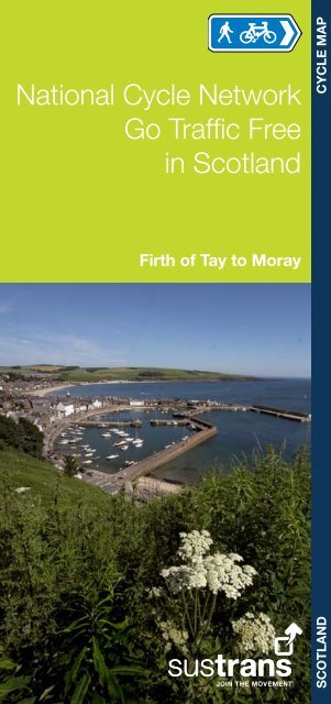
Front cover: S<strong>to</strong>nehaven harbour © David Gold<br />
Registered Charity No. 326550 (England<br />
and Wales) SC039263 (Scotland)<br />
This booklet has been produced<br />
with the support <strong>of</strong> the Scottish Goverment<br />
First edition 2009