Firth of Tay to Moray - Sustrans
Firth of Tay to Moray - Sustrans
Firth of Tay to Moray - Sustrans

Create successful ePaper yourself
Turn your PDF publications into a flip-book with our unique Google optimized e-Paper software.
Westside<br />
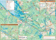
Map 9<br />
West-<strong>to</strong>wn<br />
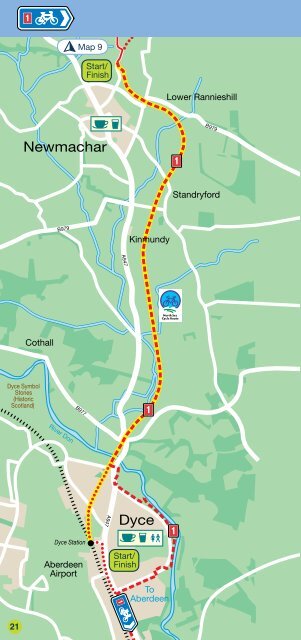
Dyce <strong>to</strong> Newmachar 8<br />
Newmachar<br />
B979<br />
Start/<br />
Finish<br />
Lower Rannieshill<br />
B979<br />
Standryford<br />
Kinmundy<br />
Category: Railway path<br />
Distance: 6 miles/10 kilometres<br />
Time: 50 minutes<br />
Gradient: Flat<br />
Surface: Whin dust<br />
Join the Formartine and Buchan Way way from Dyce railway<br />
station car park (signed). The cycleway follows the line <strong>of</strong> the<br />
disused railway all the way <strong>to</strong> Newmachar. Be aware that there<br />
are a few minor road crossings where the railway bridges have<br />
been removed. That aside, this is a route where you can really<br />
enjoy effortless cycling along this flat, traffic-free route.<br />
It’s particularly attractive in the spring and summer months when<br />
the hedgerows come alive. Rich farmland, for which this part <strong>of</strong><br />
the north-east is famed, extends on both sides. A short trip on a<br />
minor road takes you in<strong>to</strong> the <strong>to</strong>wn <strong>of</strong> Newmachar where you can<br />
eat and drink before returning by the same route, or continue <strong>to</strong><br />
explore the Formartine and Buchan Way (see map 9 for details).<br />
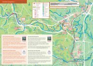
A947<br />
Miles<br />
0 0.5 1<br />
Cothall<br />
B977<br />
0 0.5 1 1.5<br />
Kilometres<br />
Dyce Symbol<br />
S<strong>to</strong>nes<br />
(His<strong>to</strong>ric<br />
Scotland)<br />
B977<br />
River Don<br />
A947<br />
Dyce<br />
Dyce Station<br />
Aberdeen<br />
Airport<br />
Start/<br />
Finish<br />
To<br />
Aberdeen<br />
21<br />
Cyclists on the Formartine and Buchan Way<br />
© Aberdeenshire Council<br />
22