sustainable forest management - Forestry Tasmania
sustainable forest management - Forestry Tasmania
sustainable forest management - Forestry Tasmania

Create successful ePaper yourself
Turn your PDF publications into a flip-book with our unique Google optimized e-Paper software.
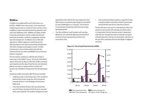
Wildfires<br />
A wildfire is an unplanned fire and is also known as a<br />
bushfire. Wildfires have many causes, some natural such<br />
as lightning and some as a result of human activity such as<br />
campfires, escapes from planned burning operations, and<br />
some from deliberate arson. Wildfires are highly variable<br />
in intensity and duration and this is determined by the<br />
interaction of weather conditions, topography, fuel load,<br />
type and arrangement. An effective and coordinated<br />
approach to wildfire suppression and fire protection<br />
planning requires close liaison and working arrangements<br />
with other emergency and support services. <strong>Forestry</strong><br />
<strong>Tasmania</strong> has a close working relationship with the<br />
<strong>Tasmania</strong> Fire Service, Parks and Wildlife Service and <strong>forest</strong><br />
industry companies.<br />
The hot weather conditions in 2007/08 were similar in<br />
many ways to the 2006/07 season. During the 2007/08 fire<br />
season, there were 42 days on which fire weather warnings<br />
were required, and five days of total fire ban were declared.<br />
8496 ha was burnt in unplanned fires of which 5551<br />
hectares was classified as having severe fire damage (Figure<br />
24).<br />
Significant wildfires during the 2007/08 season included:<br />
• A lightning strike on the Packers Spur in the Southwest<br />
National Park started a large fire, which threatened<br />
commercial <strong>forest</strong> in the Mt Wedge and Florentine<br />
Valley areas.<br />
• A fire that started at Ericksons Rd, seven kilometres<br />
west of St Helens threatened both the town and state<br />
<strong>forest</strong> until contained. The incident <strong>management</strong> team<br />
•<br />
appointed to deal with this fire was preparing to close<br />
down when it was asked to take charge of a second fire<br />
lit south of Bellingham on 16 January. This fire burnt<br />
• A fire at Heemskirk Road started as a signal fire lit after<br />
a vehicle accident in the Arthur-Pieman Conservation<br />
and threatened state <strong>forest</strong> in Murchison District.<br />
for several days, threatening state <strong>forest</strong> and nearby<br />
grazing properties<br />
Two fires at Wilsons Creek Tarraleah and Long Spur<br />
<strong>Forestry</strong> <strong>Tasmania</strong> is pro-active in attempting to reduce the<br />
area burnt and severity of fire damage on land for which<br />
it is responsible. <strong>Forestry</strong> <strong>Tasmania</strong> works in cooperation<br />
Wayatinah were started by lightning and threatened<br />
with other fire <strong>management</strong> agencies through a program<br />
commercial <strong>forest</strong>, grazing land and electricity<br />
of hazard reduction, training, communication, education on<br />
transmission lines.<br />
the use of fire, and prosecutions for the illegal or negligent<br />
use of fire.<br />
Figure Figure 24. 24. Area Area of of State state <strong>forest</strong> burnt burnt by by wildfire wildfire<br />
Total area (hectares)<br />
40,000<br />
12,000<br />
35,000<br />
10,000<br />
30,000<br />
8,000<br />
25,000<br />
20,000<br />
6,000<br />
15,000<br />
4,000<br />
10,000<br />
2,000<br />
5,000<br />
0<br />
0<br />
2001/02 2003/04 2005/06 2007/08<br />
Total unplanned fires (ha) Severe fire damage (ha)<br />
Total 10-year average (ha) Severe 10-year average (ha)<br />
Severely burnt area (hectares)