FEMA Approved LMS Plan - Tampa Bay Regional Planning Council
FEMA Approved LMS Plan - Tampa Bay Regional Planning Council
FEMA Approved LMS Plan - Tampa Bay Regional Planning Council

Create successful ePaper yourself
Turn your PDF publications into a flip-book with our unique Google optimized e-Paper software.
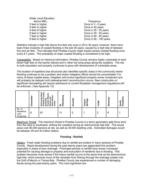
Water Level Elevation<br />
Above MSL:<br />
Frequency:<br />
3 feet or higher Once in 3 - 5 years<br />
4 feet or higher Once in 20 years<br />
5 feet of higher Once in 25 - 30 years<br />
6 feet or higher Once in 30 - 50 years<br />
7 feet or higher Once in 60 - 90 years<br />
8 feet or higher Once in 90 - 100 years<br />
Statistics indicate a high tide above five feet only once in 25 to 30 years, however, there have<br />
been three incidents of coastal flooding in the last 26 years, caused by a high tide of between<br />
five and six feet. This indicates that Pinellas County might expect severe coastal flooding once<br />
every 8.7 years. The probability of major coastal flooding is considered to be high.<br />
Vulnerability: Based on historical information, Pinellas County remains highly vulnerable to wind<br />
blown high tide on the barrier islands and in other low lying areas along the coastline. The risk<br />
to both population and property continues to grow with development of vulnerable areas.<br />
The location of repetitive loss structures also identifies specific areas in the community where<br />
flooding continues to be a problem and where mitigation efforts should be concentrated. For<br />
many of these coastal areas, mitigation will involve significant property owner investment and<br />
will probably be delayed until redevelopment/ reconstruction occurs. New construction or<br />
significant remodeling will require adherence to current floodplain management regulations will<br />
be enforced. ( See Appendix 13)<br />
Clearwater<br />
Unincorporated<br />
Pinellas County<br />
(primarily<br />
Crystal Beach,<br />
Ozona and<br />
Palm Harbor<br />
areas)<br />
St.<br />
Petersburg<br />
Dunedin<br />
Tarpon<br />
Springs<br />
Largo<br />
Seminole<br />
South<br />
Pasadena<br />
No. of<br />
Repetitive<br />
Loss<br />
Properties<br />
6 61 11 2 1 2 6 1<br />
Maximum Threat: The maximum threat to Pinellas County is a storm generation gale force wind<br />
from the west or southwest, striking the coastline during an astronomical high tide. This would<br />
place over 60,000 persons at risk, as well as 30,000 dwelling units. Estimated damages would<br />
be between 30 and 40 million dollars.<br />
Flooding - Rainfall<br />
History: Fresh water flooding problems due to rainfall are evident in many sections of Pinellas<br />
County. Rapid development during the past twenty years has aggravated this problem,<br />
especially in areas of poor drainage. Prolonged periods of rainfall have shown increased<br />
potential for causing damage to property and evacuation of residents due to flooding. This<br />
problem becomes more severe if the heavy rainfall occurs at the same time as the astronomical<br />
high tide, which prevents much of the rainwater from flowing through the drainage system into<br />
the Gulf of Mexico or <strong>Tampa</strong> <strong>Bay</strong>. Pinellas County has experienced a number of damaging<br />
floods during the past twenty years. The most significant are:<br />
1-11