Manhattan Full Report.pdf - Will County Land Use
Manhattan Full Report.pdf - Will County Land Use
Manhattan Full Report.pdf - Will County Land Use

You also want an ePaper? Increase the reach of your titles
YUMPU automatically turns print PDFs into web optimized ePapers that Google loves.
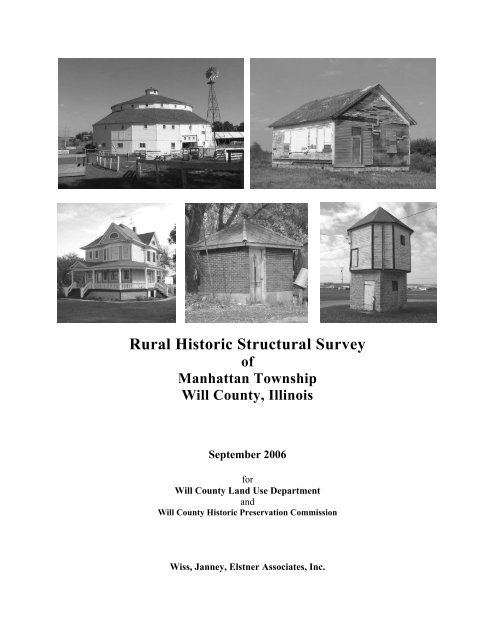
Rural Historic Structural Survey<br />
of<br />
<strong>Manhattan</strong> Township<br />
<strong>Will</strong> <strong>County</strong>, Illinois<br />
September 2006<br />
for<br />
<strong>Will</strong> <strong>County</strong> <strong>Land</strong> <strong>Use</strong> Department<br />
and<br />
<strong>Will</strong> <strong>County</strong> Historic Preservation Commission<br />
Wiss, Janney, Elstner Associates, Inc.
Wiss, Janney, Elstner Associates, Inc.<br />
330 Pfingsten Road<br />
Northbrook, Illinois 60062<br />
(847) 272-7400<br />
www.wje.com
Wiss, Janney, Elstner Associates, Inc.<br />
Rural Historic Structural Survey<br />
<strong>Manhattan</strong> Township<br />
<strong>Will</strong> <strong>County</strong>, Illinois<br />
TABLE OF CONTENTS<br />
Executive Summary<br />
vii<br />
Chapter 1 – Background and Methodology<br />
Background 1<br />
Survey Methodology 1<br />
Survey Gaps and Future Research 2<br />
Chapter 2 – Context History of the Rural Survey Area<br />
Geologic and Topographic Background to the Illinois Region 3<br />
First Nations in the Illinois Region 4<br />
The Arrival of European Settlers 5<br />
Settlement and Development of Northeast Illinois 9<br />
<strong>Manhattan</strong> Township Development History 17<br />
Chapter 3 – American Rural Architecture<br />
Farmstead Planning 25<br />
Development of Balloon Framing 25<br />
Masonry Construction 29<br />
Classification of Farmhouses 35<br />
Development of the Barn 45<br />
Chapter 4 – Survey Summary and Recommendations<br />
Period of Significance: 1845 to 1970 65<br />
Significance 65<br />
Potential Historic Districts, Thematic Designations, and <strong>Land</strong>marks 69<br />
Survey Summary 71<br />
Notable Farmsteads in <strong>Manhattan</strong> Township 95<br />
Bibliography 117<br />
Glossary 133<br />
Appendix A: Historic Atlas and Plat Maps of <strong>Manhattan</strong> Township<br />
Appendix B: 1939 aerial photography of <strong>Manhattan</strong> Township<br />
Appendix C: Maps<br />
Map 1 – <strong>Will</strong> <strong>County</strong> Key Map<br />
Map 2 – Overview of Survey<br />
Map 3 – Existing House Types<br />
Map 4 – Existing Barn Types<br />
Map 5 – Historical Significance<br />
Map 6 – Proposed <strong>Manhattan</strong>-Green Garden Rural Heritage District<br />
Map 7 – Proposed Midewin National Tallgrass Prairie Rural Buffer District<br />
<strong>Will</strong> <strong>County</strong> Rural Historic Structural Survey<br />
<strong>Manhattan</strong> Township<br />
v
Wiss, Janney, Elstner Associates, Inc.<br />
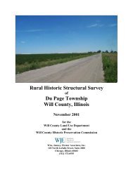
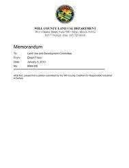
This wooden trestle, now abandoned, carried the Wabash Railroad over Prairie Creek in Section 31 of <strong>Manhattan</strong> Township.<br />
vi<br />
<strong>Will</strong> <strong>County</strong> Rural Historic Structural Survey<br />
<strong>Manhattan</strong> Township
Wiss, Janney, Elstner Associates, Inc.<br />
Executive Summary<br />
At the request of the <strong>Will</strong> <strong>County</strong> <strong>Land</strong> <strong>Use</strong> Department, acting as liaison for the <strong>Will</strong> <strong>County</strong> Historic<br />
Preservation Commission, Wiss, Janney, Elstner Associates, Inc. (WJE) has prepared this summary report<br />
of the 2005–2006 intensive survey of farmsteads in <strong>Manhattan</strong> Township in <strong>Will</strong> <strong>County</strong>, Illinois. The<br />
survey included thirty-six square miles with 120 farmsteads and related sites containing more than 700<br />
individual structures.<br />
The earliest settlers of European descent established homesteads in <strong>Manhattan</strong> Township beginning in the<br />
mid 1830s at Five Mile Grove. Intensive agricultural settlement did not begin, however, until the late 1840s.<br />
Settlement increased following the construction of the Illinois Central Railroad in the early 1850s, and<br />
<strong>Manhattan</strong> was organized as an independent township in 1853. The opening of the Wabash Railroad in 1880<br />
led to the establishment of the village of <strong>Manhattan</strong>. Also, farmers in <strong>Manhattan</strong> Township were more<br />
directly connected to markets in Chicago. With the construction of interstate highways in the 1960s,<br />
suburban residential development began to occur in <strong>Manhattan</strong> Township. The growth of the village as a<br />
residential community has greatly accelerated in the late 1990s and 2000s.<br />
Of the 120 farmsteads identified in the current survey, two sites have already been listed as <strong>Will</strong> <strong>County</strong><br />
<strong>Land</strong>marks: the John C. Baker Barn and the Paton School. Additionally, thirty-two sites have the potential<br />
to be considered for <strong>Will</strong> <strong>County</strong> Historic <strong>Land</strong>mark designation or listing on the National Register of<br />
Historic Places. In some cases, the eligibility of the site would be enhanced if certain historic features were<br />
restored or non-historic cladding materials such as vinyl siding were removed. Other sites have either been<br />
designated Contributing, which means in the context of this report that they retain their overall character as<br />
historically agricultural sites but lack individual distinction; or Non-contributing, which indicates that the<br />
site lacks sufficient integrity to present the theme of agricultural history in the survey region. Two potential<br />
landmark districts were identified: one rural heritage district encompassing mainly agricultural land in<br />
eastern <strong>Manhattan</strong> and western Green Garden Townships; and one buffer district encompassing historically<br />
agricultural land adjacent to the Midewin National Tallgrass Prairie southwest of <strong>Manhattan</strong>.<br />
The <strong>Manhattan</strong> Township intensive survey was performed to update the previous survey of the township<br />
performed in 1988. In the previous survey, 135 farmsteads and related sites were identified in <strong>Manhattan</strong><br />
Township, containing at least 800 structures. Because of the rapid pace of contemporary development in<br />
<strong>Will</strong> <strong>County</strong> since 1988, the <strong>Will</strong> <strong>County</strong> Historic Preservation Commission recognized the need to reassess<br />
the agricultural heritage of the region. WJE has previously completed five intensive survey projects<br />
covering Wheatland, Plainfield, Lockport, DuPage, Homer, New Lenox, and Green Garden Townships.<br />
Copies of the previous survey reports were provided to public libraries in the area. Cumulatively, the<br />
surveys have identified over 3,400 structures on about 775 sites over 288 square miles of <strong>Will</strong> <strong>County</strong>.<br />
Performing a separate survey for each township has allowed more detailed information to be collected, such<br />
as individual photographs of each historic structure, an assessment of current building condition, and<br />
preparation of site sketch plans. With the permission of property owners, the survey work was performed<br />
with close-up access to the buildings, which allowed for close range photography and a reliable<br />
identification of building materials. The survey data was compiled and analyzed using database software<br />
and geographic information system (GIS) software.<br />
In this report, Chapter 1 contains a description of the project methodology. Chapters 2 and 3 provide the<br />
architectural and historical context within which the surveyed farmsteads were established, grew, were<br />
reconfigured, and in some cases were abandoned. Chapter 2, Context History, covers the historical context<br />
of <strong>Will</strong> <strong>County</strong> agriculture, as well as the historical development of <strong>Manhattan</strong> Township. Chapter 3<br />
discusses the architectural context of the rural survey area. Chapter 4 summarizes the survey results and<br />
includes a discussion of the National Register and <strong>Will</strong> <strong>County</strong> criteria for designation of historical and<br />
<strong>Will</strong> <strong>County</strong> Rural Historic Structural Survey<br />
<strong>Manhattan</strong> Township<br />
vii
Wiss, Janney, Elstner Associates, Inc.<br />
architectural significance. Also in Chapter 4 are several tabulations of the survey results and an overview of<br />
a select number of historically and/or architecturally significant farmsteads. A bibliography of research<br />
sources follows the text. Appendices include historic and contemporary plat maps for <strong>Manhattan</strong> Township;<br />
and maps developed for this report to present the results of the survey and research.<br />
viii<br />
<strong>Will</strong> <strong>County</strong> Rural Historic Structural Survey<br />
<strong>Manhattan</strong> Township
Wiss, Janney, Elstner Associates, Inc.<br />
CHAPTER 1<br />
BACKGROUND AND METHODOLOGY<br />
Background<br />
At the request of the <strong>Will</strong> <strong>County</strong> <strong>Land</strong> <strong>Use</strong> Department, acting as liaison for the <strong>Will</strong> <strong>County</strong> Historic<br />
Preservation Commission, Wiss, Janney, Elstner Associates, Inc. (WJE) has prepared this summary report<br />
of the intensive survey of farmsteads in <strong>Manhattan</strong> Township in <strong>Will</strong> <strong>County</strong>, Illinois. A previous survey<br />
of farmsteads in <strong>Will</strong> <strong>County</strong> was performed in 1988. Beginning in 1999, WJE has prepared intensive<br />
surveys of individual townships in <strong>Will</strong> <strong>County</strong>. Previous townships surveyed included Plainfield,<br />
Wheatland, and Lockport (completed November 2000), DuPage (November 2001), Homer (November<br />
2002), New Lenox (August 2003), and Green Garden (July 2004). It is intended that Frankfort Township<br />
will be the next township to be surveyed.<br />
The objectives of the study are to provide comprehensive information on all historic rural structures<br />
located in the area; to assess the eligibility of rural districts or individual buildings for designation as local<br />
landmarks or nomination to the National Register of Historic Places; to inventory the existing structures<br />
in the area for future study; to provide background on significant architectural styles and rural structure<br />
types common to the area; and to provide background history of the development of the area. The present<br />
study has been developed to meet the requirements and standards of the Certified Local Government<br />
program.<br />
Survey Methodology<br />
Survey Team<br />
The survey team from WJE consisted of Kenneth Itle, Craig Droba, Renae Brossman, Jean Tamisin, and<br />
Deborah Slaton. Mr. Itle served as Project Manager and developed the summary report and performed<br />
some field survey work. Mr. Droba, Ms. Brossman, Ms. Tamisin, and Mr. Itle performed field survey<br />
work. Ms. Slaton was the reviewer of the summary report.<br />
Background Research<br />
Work on the rural survey began in August 2005. Background research was performed at the State of<br />
Illinois Library, Springfield; the University of Illinois Libraries, the Joliet Public Library, and the<br />
<strong>Manhattan</strong> Public Library. In addition, extensive historic research materials compiled for previous <strong>Will</strong><br />
<strong>County</strong> rural survey reports were available.<br />
Field Survey<br />
A project initiation meeting was held to discuss the project approach and scope. Field survey work<br />
proceeded in August, September, and October 2005. The field survey work began with a reconnaissance<br />
survey to identify existing farmstead sites. Following the identification of sites, an intensive survey was<br />
performed of each site. The survey team first approached the primary residence on the site to request<br />
permission of the homeowner/tenant to conduct the survey on the farmstead site. At sites where no one<br />
was home, or where owner permission was not provided, the site was surveyed from the public right-ofway.<br />
Typically each structure on the site was photographed individually using a digital camera. A sketch<br />
plan of the farmstead was prepared. Written notes for each building included a listing of exterior<br />
materials, overall condition, and estimated decade of construction based on structural type and style. Any<br />
history information provided by the owner, such as dates of construction or names of original owners,<br />
were also noted.<br />
<strong>Will</strong> <strong>County</strong> Rural Historic Structural Survey<br />
<strong>Manhattan</strong> Township Page 1
Wiss, Janney, Elstner Associates, Inc.<br />
Database and Base Map Preparation<br />
Mapping for the survey was prepared using ArcGIS. 1 Baseline mapping showing roads, railways, streams,<br />
township boundaries, etc., as well as 2005 aerial photography of the survey area, was downloaded from<br />
the Illinois Natural Resources Geospatial Data Clearinghouse internet site. 2 Individual points were added<br />
to the baseline map at the location of each farmstead site surveyed. Each point represents a particular<br />
record in the Microsoft Access database. The database contains all field survey information; historical<br />
information specific to each property, such as names of previous owners based on historic atlases and plat<br />
maps; and the assessment of historic significance. On the database forms, the “notes” field typically<br />
contains other miscellaneous observations of the project team from the field work. Occasionally, this field<br />
contains verbal information for the resident or another source; these are so noted.<br />
Prior to inserting the digital photographs into the database, the photograph files were converted from<br />
color .jpg files to reduced-size black-and-white .bmp files. The Microsoft Access database was used to<br />
generate the property lists included in this summary report, as well as the individual survey forms. The<br />
ArcGIS software was used to generate the maps of the survey area included in the appendix.<br />
Presentations<br />
A presentation of the draft survey results was made to the <strong>Will</strong> <strong>County</strong> Historic Preservation Commission<br />
(HPC) on 7 June 2006. The final summary report incorporates comments provided by the HPC members.<br />
<strong>Report</strong> and Submittals<br />
The summary report was prepared using Microsoft Word. <strong>Will</strong> <strong>County</strong> was provided with the following<br />
final materials under separate cover: printed copies of the final summary report; printed copies of the<br />
individual property survey forms; digital photographs as original color .jpg files; ArcGIS mapping files;<br />
Microsoft Access database file; survey sheets as .<strong>pdf</strong> file; and report text as Microsoft Word file and .<strong>pdf</strong><br />
file.<br />
Survey Gaps and Future Research<br />
The present study is not meant to be a definitive review of the history of each property surveyed; rather,<br />
based on historic research and field survey, the relative significance of each property has been assessed.<br />
In the future, as new development or renovation work may affect particular properties, the history and<br />
significance of the particular property should be researched in detail, using the present survey as a starting<br />
point.<br />
The present study focused on architectural features of the survey region. Other studies could be<br />
undertaken to assess the archaeological potential of the survey region; to identify and assess cultural<br />
landscape features such as fence rows, hedges, and earthworks; to study historic transportation<br />
infrastructure and routes in detail; or to study particular architectural themes, such as limestone masonry<br />
construction, in greater detail.<br />
1 GIS stands for geographic information system, a computerized methodology for organizing data geographically.<br />
2 http://www.isgs.uiuc.edu/nsdihome/<br />
Page 2<br />
<strong>Will</strong> <strong>County</strong> Rural Historic Structural Survey<br />
<strong>Manhattan</strong> Township
Wiss, Janney, Elstner Associates, Inc.<br />
CHAPTER 2<br />
CONTEXT HISTORY OF THE RURAL SURVEY AREA<br />
Geologic and Topographic Background to the Illinois Region<br />
As with most of Illinois, the survey area was profoundly altered by glaciation. Over approximately one<br />
million years during the Pleistocene era, the northern hemisphere was alternately covered by, and free of,<br />
large ice sheets that were hundreds to a few thousand feet thick. Pleistocene glaciers and the waters melting<br />
from them changed the landscapes they covered. The ice scraped and smeared the landforms it overrode,<br />
leveling and filling many of the minor valleys and even some of the larger ones. Moving ice carried colossal<br />
amounts of rock and earth, for much of what the glaciers wore off the ground was kneaded into the moving<br />
ice and carried along, often for hundreds of miles.<br />
A significant feature left by the advance and retreat of glaciers in the northeast corner of the state are<br />
glacial moraines—low mounds tens of miles long left by the furthest advance of a glaciers in the<br />
Wisconsinan period. <strong>Manhattan</strong> Township lies almost entirely within one of the most pronounced<br />
moraines, the Valparaiso Morainic System. The portion of this system of moraines in the township is<br />
appropriately named the <strong>Manhattan</strong> Moraine.<br />
The northern part of the township is drained by Jackson Creek, which flows from east to west from<br />
Section 1 to Section 7. The southern part of the township is drained by Prairie Creek, which flows from<br />
east to west from Sections 13 and 24 to Section 30. Other smaller streams in the township are tributaries<br />
to these creeks. Both Jackson and Prairie Creeks flow generally west by southwest, ultimately draining<br />
into the Kankakee River just upstream of the meeting point of the Kankakee and Des Plaines Rivers, the<br />
start of the Illinois River. The small valleys carved out by the creeks are readily apparent in the township,<br />
particularly in Section 30 and while traveling along Baker Road between Sections 5 and 8.<br />
The last ice sheets in this area began to retreat approximately 13,500 years ago. The retreating and<br />
melting glaciers continued to impact the area for a few more thousand years, as the outflow deposited<br />
sand and gravel.<br />
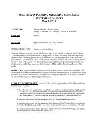
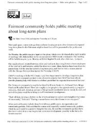
The gently rolling landscape of <strong>Manhattan</strong> Township is defined by several creek valleys, such as Prairie Creek, seen here at the<br />
Scheer Road bridge in Section 24.<br />
<strong>Will</strong> <strong>County</strong> Rural Historic Structural Survey<br />
<strong>Manhattan</strong> Township Page 3
Wiss, Janney, Elstner Associates, Inc.<br />
First Nations in the Illinois Region<br />
Human habitation of the North American continent from the Paleo-Indian culture has been dated to the<br />
end of the last glacial advance (about 15,000 to 12,000 years ago). Increasing warmth toward the close of<br />
the Pleistocene Era caused the melting and disappearance of the ice sheet in approximately 9000 B.C. The<br />
arrival of the First Nations, or Native Americans, in the region between the middle Mississippi valley and<br />
Lake Michigan appears to date from the earliest period following the retreat of the polar ice sheet. This<br />
time is known as the Paleo-Indian Period, when peoples in the region briefly occupied campsites while<br />
subsisting on deer, small mammals, nuts, and wild vegetables and other plants.<br />
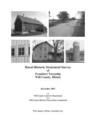
Illustrated above are the moraine systems in northeastern Illinois. <strong>Manhattan</strong> Township lies primarily in the <strong>Manhattan</strong> Moraine<br />
of the Valparaiso Morainic System. (H.B. <strong>Will</strong>man, Summary of the Geology of the Chicago Area, Illinois State Geological<br />
Survey Circular 460 (Urbana, Illinois, 1971), 43.)<br />
Page 4<br />
<strong>Will</strong> <strong>County</strong> Rural Historic Structural Survey<br />
<strong>Manhattan</strong> Township
Wiss, Janney, Elstner Associates, Inc.<br />
The first signs of specific colonization date from the Archaic Period, prior to 1000 B.C., when deer<br />
hunting and wild plant gathering supported a dispersed population. As climatic conditions changed over<br />
the next several thousand years, populations tended to concentrate near river floodplains and adjacent<br />
areas. In the Woodland Period (1000 B.C. to A.D. 1000), crude grit-tempered pottery appeared in<br />
northeastern Illinois. The end of this period saw the advent of large fortified towns with platform mounds,<br />
such as the community at Cahokia located east of St. Louis. Further north, villages in the upper Illinois<br />
River Valley lacked large platform mounds. 3 It was also a period of a widespread trading network known<br />
to modern anthropology as the Hopewell Interaction Sphere. The villages of this period were typically<br />
located on valley bottom lands, close to river transportation. Agricultural development included<br />
cultivation of floodplain lands; by A.D. 650 maize was being grown in the Illinois River valley. 4<br />
The time span between A.D. 1000 and the coming of European explorers and settlers is known as the<br />
Mississippian Period. Northeast Illinois was at the fringe of the larger Middle Mississippi culture present<br />
in central and southern Illinois. At the beginning of this period, the communities of large fortified towns<br />
and ceremonial platform mounds reached their zenith. Among these sites in northeastern Illinois is the<br />
Fisher site in <strong>Will</strong> <strong>County</strong>, located in Channahon Township.<br />
The Arrival of European Settlers<br />
French Explorers and Settlers in the Illinois Territory<br />
By the time of the French explorations of the seventeenth century, the native inhabitants of Illinois as a<br />
group belonged to the Algonquian linguistic family, closely related to the Chippewa. The specific tribes<br />
in the northeast Illinois region included the Miami (located on sites near the Calumet River, the juncture<br />
of the Des Plaines and Kankakee Rivers, and the Fox River) and the Illinois (present throughout the rest<br />
of modern-day Illinois). “Illinois” was a native word signifying “men” or “people.” 5 By the early to mid-<br />
1700s, the Potawatomi moved into the area from the region of Michigan and northern Wisconsin.<br />
In 1673, the expedition of Father Jacques Marquette and Louis Jolliet traveled primarily along the<br />
Mississippi River and up the Illinois River to the region of Cook and <strong>Will</strong> Counties. 6 This expedition<br />
claimed the region for France. In 1678, an expedition led by Robert de La Salle with Henry Tonti and<br />
Father Hennepin explored the region along the Mississippi River and adjacent territory on behalf of<br />
France. A Jesuit mission was established at Chicago in 1696 by Father Pierre Pinet, but it failed to last<br />
more than a year. As time progressed the French centered their principal activities in the middle<br />
Mississippi valley, focusing on Fort de Chartres near Kaskaskia and its connections with Québec via the<br />
3 Several Woodland sites are present in the river valleys of the Des Plaines and DuPage Rivers. (John Doershuk,<br />
Plenemuk Mound and the Archaeology of <strong>Will</strong> <strong>County</strong>, Illinois Cultural Resource Study No. 3 (Springfield, Illinois:<br />
Illinois Historic Preservation Agency, 1988), 11–14).<br />
4 James E. Davis, Frontier Illinois (Bloomington, Indiana: Indiana University Press, 1998), 25. “The Late Woodland<br />
is a period of increasing dependence on corn agriculture, although northeastern Illinois groups appear less corndependent<br />
than do central and lower Illinois River valley peoples.” (Doershuk, Plenemuk Mound and the<br />
Archaeology of <strong>Will</strong> <strong>County</strong>, 13–14.)<br />
5 John R. Swanton, The Indian Tribes of North America (1952, Bureau of American Ethnology Bulletin Number<br />
145; reprint, Washington, D.C.: Smithsonian Institution Press, 1969), 241.<br />
6 Louis Jolliet was born at Beauport, near Québec, in September 1645. He began to study at the Jesuit College of<br />
Québec in 1655 and in 1662 he received minor religious orders from Bishop Laval. After leaving the seminary and<br />
becoming a fur trader, he gained proficiency in surveying and mapmaking. Jolliet was chosen by the government of<br />
France to be a member of a delegation meeting with the chieftains of the Indian tribes assembled at Sault Sainte<br />
Marie in 1671. Beginning the next year, Jolliet led an expedition down the Mississippi, during which he traveled up<br />
the Illinois and Des Plaines Rivers. During this expedition he surmised that digging a canal from to connect the<br />
waterways in this region would allow transportation from the Great Lakes to the Mississippi and the Gulf of Mexico.<br />
The Illinois and Michigan Canal constructed in the 1830s and 1840s was the realization of this route.<br />
<strong>Will</strong> <strong>County</strong> Rural Historic Structural Survey<br />
<strong>Manhattan</strong> Township Page 5
Wiss, Janney, Elstner Associates, Inc.<br />
Ohio, Maumee, and Wabash rivers and the Great Lakes, well to the south and east of the upper Illinois<br />
valley.<br />
During this period, the Native Americans were undergoing migrations, often leading to conflict among<br />
the various tribes. The Sauk, Fox, Kickapoo, and Potawatomi displaced the Miami and Illinois in the<br />
Chicago region. The Potawatomi, followed by the Sauk and the Fox, were the predominant peoples in the<br />
northeastern Illinois by the later 1700s. Also present in the region were the Winnebago and the Shawnee. 7<br />
French colonial settlers in the southern and central portions of Illinois brought with them traditional<br />
agricultural practices from northern France, including open-field plowlands divided into longlots, and<br />
communal pasturing areas. 8 However, unlike labor practices in France, colonial settlers utilized African<br />
slaves. By the middle of the eighteenth century, black slaves were one-third of the region’s population.<br />
Early settlements founded as missions and fur trading posts, such as Cahokia and Kaskaskia, developed<br />
into the core of agricultural communities. 9 French colonial farms produced wheat for human consumption<br />
and maize as feed for hogs. A staple of the settlers’ diet was wheat bread. Livestock for use as dairy<br />
production, meat consumption, and draft animals were also present on the region’s farms. The open field<br />
agriculture system continued in use beyond the era of French domination, and ended only with the influx<br />
of settlers from the east coast after 1800. 10<br />
Illinois in the English Colonial Period and Revolutionary War<br />
<strong>Land</strong> ownership was not an original right when the Virginia Company settled Jamestown in 1607. The<br />
company owned the land and paid its employees for their labor in food and supplies out of a common<br />
storehouse, limiting their motivation to farm. After a period of starvation that nearly wiped out the<br />
settlement, the company gave each employee an incentive of a three-acre garden, which led to regular<br />
land distribution consisting of a 50 acre “headright.” 11<br />
French influence in the Illinois territory began to wane by the mid-1700s. Québec on the St. Lawrence<br />
River fell to the British in September 1759 during the French and Indian War, opening a route through the<br />
Great Lakes to the middle part of the continent. In 1763, the French ceded land east of the Mississippi to<br />
the British. In October 1765, the British took possession of Fort Chartres (and briefly renamed it Fort<br />
Cavendish), extending British authority across the continent east of the Mississippi River. Unchallenged<br />
British control of the Illinois region lasted until the Revolutionary War. In 1778, at the direction of the<br />
Governor of Virginia, George Rogers Clark led an expedition against the British and captured their posts<br />
in the frontier northwest. Clark marched across southern Illinois, and by July 1778 had disarmed the<br />
British-held frontier forts of Kaskaskia, Cahokia, and Vincennes, claiming the region for the newly<br />
independent American colonies.<br />
7 Jean L. Herath, Indians and Pioneers: A Prelude to Plainfield, Illinois (Hinckley, Illinois: The Hinckley Review,<br />
1975), 20–21.<br />
8 Carl J. Ekberg, French Roots in the Illinois Country: The Mississippi Frontier in Colonial Times (Urbana, Illinois:<br />
University of Illinois Press, 1998), 2–3. “Longlots” are, as the name implies, long narrow plots of cultivated land<br />
that developed because of the difficulty for plowing teams to turn around. Forms of longlots date back to ancient<br />
Mesopotamia; French colonial forms developed from Medieval European models. The longlots in Illinois typically<br />
had length to width ratios of 10 to 1.<br />
9 Ibid., 33.<br />
10 Ibid., 173–251.<br />
11 John Opie, The Law of the <strong>Land</strong>: Two Hundred Years of Farm Policy (Lincoln: University of Nebraska Press,<br />
1994), 19.<br />
Page 6<br />
<strong>Will</strong> <strong>County</strong> Rural Historic Structural Survey<br />
<strong>Manhattan</strong> Township
Wiss, Janney, Elstner Associates, Inc.<br />
<strong>Land</strong> Division and Distribution in the New Nation<br />
When land claims of several of the newly independent states overlapped, Congress, under the Articles of<br />
Confederation, struggled to maintain control over the territory extending to the Mississippi River. After<br />
making all land west of the Pennsylvania Line to the Mississippi common national property, a system of<br />
land division was developed based on meridians and base lines, which were subdivided further into a<br />
series of rectangular grids. In the “Rectangular System,” distances and bearing were measured from two<br />
lines which are at right angles to each other: the Principal Meridians, which run north and south, and the<br />
Base Lines, which run east and west. Subdividing lines called Range Lines are spaced at six mile intervals<br />
between the meridians and base lines. Range Lines defined territories known as townships. 12<br />
On 20 May 1785, Congress adopted this system as the <strong>Land</strong> Survey Ordinance of 1785. (Eventually,<br />
frontier settlers west of Pennsylvania and north of Texas could walk up to a plat map on the wall of a<br />
regional land office and select a one quarter section property for farming, which was thought to be<br />
sufficient to sustain individual farmers. 13 ) In 1787, after about twenty months of surveying work, the first<br />
national public land sales occurred, consisting of 72,934 acres with $117,108.22 in revenue. 14 Also in that<br />
year, the Ordinance of 1787 organized the Northwest Territory, including what would become Illinois,<br />
Indiana, Michigan, Ohio, and Wisconsin.<br />
After the ratification of the new United State Constitution, land legislation was not addressed for several<br />
years. Meanwhile, settlement continued on the portions already surveyed and sold by the government, and<br />
extended into unsurveyed land with settlement by squatters (many of whom were later evicted by federal<br />
troops). Additional federal land sales took place in 1796, and in 1800 the government opened land offices<br />
in Cincinnati, Chillicothe, Marietta, and Steubenville, all in Ohio.<br />
Development of the Northwest Territory<br />
In 1801 Illinois, then part of the Northwest Territory, became part of the Indiana Territory. Eight years<br />
later the Illinois Territory was formed, including the region of Wisconsin. By 1800, fewer than 5,000<br />
settlers lived in the territorial region, with most located in the southern portion of what became Illinois<br />
along the Mississippi, Ohio, and Wabash Rivers. The northern portion of the state was more sparsely<br />
populated, as European settlers did not begin to enter this area until the early years of the 1800s.<br />
At this time, the Native American tribe leader Tecumseh organized the tribes of the Northwest Territory<br />
against European settlers. Although defeated in the Battle of Tippecanoe of 1811, Tecumseh remained<br />
active throughout the War of 1812 and aided British forces in capturing many European-settled areas.<br />
These reverted to American control at the end of the war. A series of treaties with Native American<br />
populations influenced the future of northeast Illinois. In 1795, a peace treaty with Native Americans<br />
included the ceding of “one piece of land, six miles square, at the mouth of the Chicago River, emptying<br />
12 Townships were the largest subdivision of land platted by the United States. After the Township Corners were<br />
located, the Section and Quarter Section Corners were established. Each Township was six miles square and<br />
contained 23,040 acres, or 36 square miles, as nearly as possible to fit specific geographic conditions such as lakes<br />
and rivers, political boundaries such as State boundaries, as well as survey errors. Each Township, unless irregular in<br />
shape due to the factors cited above, was divided into 36 squares called Sections. These Sections were intended to be<br />
one mile, or 320 rods, square and contain 640 acres of land. Sections were numbered consecutively from 1 to 36,<br />
utilizing the same criss-cross numbering pattern on each section regardless of national location or actual township<br />
configuration. Sections were subdivided into various smaller parcels for individual farms. A half section contains<br />
320 acres; a quarter section contains 160 acres; half of a quarter contains 80 acres, and quarter of a quarter contains<br />
40 acres, and so on. Today, legal descriptions of real estate continue to describe parcels according to the portion of<br />
the section within which they are located.<br />
13 Opie, The Law of the <strong>Land</strong>, 10.<br />
14 Ibid., 15.<br />
<strong>Will</strong> <strong>County</strong> Rural Historic Structural Survey<br />
<strong>Manhattan</strong> Township Page 7
Wiss, Janney, Elstner Associates, Inc.<br />
into the southwest end of Lake Michigan, where a fort formerly stood.” 15 It was on this land that Fort<br />
Dearborn was established in 1803, where a settlement of French traders and their Native American wives<br />
developed. The site grew initially from the fur trade, and despite the Fort Dearborn Massacre of 1812,<br />
more settlers came to the area.<br />
Cutting across the western half of the region later known as <strong>Will</strong> <strong>County</strong> was a land corridor ceded by the<br />
Potawatomi, Ottawa, and Chippewa in a treaty signed in St. Louis on 24 August 1816. The corridor,<br />
defined by the cartographic features now known as the Indian Boundary Lines (and still present on many<br />
maps of the area), was meant to allow European settlers access to Lake Michigan for the construction of a<br />
waterway (later developed as the Illinois and Michigan Canal). The corridor was physically surveyed by<br />
James M. Duncan and T.C. Sullivan in 1819; its southern boundary was defined by a line drawn from a<br />
point on the shore of Lake Michigan ten miles south of the Chicago River, to a point on the Kankakee<br />
River ten miles north of its mouth. 16<br />
Left: The first plat of survey for <strong>Manhattan</strong> Township, dated 1829, which included the land north of the Indian Boundary Line.<br />
Right: The plat of survey for the southeastern portion of <strong>Manhattan</strong> Township, dated 1839; the land south of the Indian Boundary<br />
Line was officially open for European settlement after the 1833 treaty between the United States and the Potawatomi, Ottawa,<br />
and Chippewa tribes. On the plats of survey, note the blue pencil shading to indicate ponds or sloughs, and the green circle<br />
indicating the small wooded area in Sections 7 and 8.<br />
Illinois Statehood<br />
The United States Congress passed an enabling act on 18 April 1818 admitting Illinois as the twenty-first<br />
state as of 3 December 1818. A bill had passed Congress in early 1818 moving the northern boundary<br />
northward to include the mouth of the Chicago River within the Illinois Territory. 17 The act passed despite<br />
15 As quoted by A.T. Andreas in his History of Chicago, from the Earliest Period to the Present Time (Chicago: A.T.<br />
Andreas, 1884), 79.<br />
16 <strong>Will</strong> <strong>County</strong> Property Owners, 1842 (Joliet, Illinois: <strong>Will</strong> <strong>County</strong> Historical Society, 1973), 1.<br />
17 The northern boundary of the Illinois Territory was on an east-west line from the southern line of Lake Michigan.<br />
In order to give the future state a portage on Lake Michigan, the boundary line was moved 10 miles north of the<br />
initial boundary. The Congressional legislation was amended before passage, moving the future state’s northern<br />
boundary a total of 51 miles north. This gave the region more potential economic security as well as less potential<br />
for the area to align politically with the slave states of the South.<br />
Page 8<br />
<strong>Will</strong> <strong>County</strong> Rural Historic Structural Survey<br />
<strong>Manhattan</strong> Township
Wiss, Janney, Elstner Associates, Inc.<br />
the fact that the population of the state was only 40,258, less than the 60,000 required by the Ordinance of<br />
1787. The state capital was established first at Kaskaskia and moved to Vandalia two years later. Much of<br />
the land in the state was the property of the United States government. Early sales offices were located at<br />
Kaskaskia, Shawneetown, and Vincennes. Until the financial panic of 1819, there was an initial rush of<br />
sales and settlement at the southern end of the state where navigable streams and the only road system<br />
were located. 18<br />
The Native Americans who occupied the area at this time were divided into powerful tribes who at times<br />
fought the European settlers to hold their hunting grounds. Chief among these tribes was the Kickapoo,<br />
who were among the first to engage in war with European settlers and the last to enter into treaties with<br />
the United States government. On 30 July 1819, by the Treaty at Edwardsville, the Kickapoo ceded their<br />
land to United States and began to retreat to Osage <strong>County</strong>. By 1822, only 400 Kickapoo were left in the<br />
state. The 1832 Peace Treaty of Tippecanoe was negotiated with the Potawatomi tribe, resulting in the<br />
ceding of the land now occupied by Chicago and Joliet to the federal government.<br />
The early 1830s saw the greatest land boom to that date in American history. <strong>Land</strong> sales gradually came<br />
under the control of the General <strong>Land</strong> Office as the survey moved westward. In 1834 and 1835 alone, 28<br />
million acres were shifted from closed to open land for purchase. Two years later the Van Buren<br />
administration placed an enormous 56,686,000 acres on the market. These lands were located in some of<br />
the most fertile farming regions of the nation: Illinois, Iowa, Alabama, Mississippi, Arkansas, and<br />
Missouri. 19 The building of the Illinois and Michigan Canal in the later 1830s and 1840s (discussed in<br />
Chapter 2) led to a land boom in Chicago, which had been platted in 1830 and incorporated in 1833. 20 The<br />
rate of growth in northern Illinois soon matched and then surpassed that in the southern portion of the<br />
state.<br />
Settlement and Development of Northeast Illinois<br />
By 1826, more European settlers began to move to the northeast Illinois region, so that by 1831 a few<br />
hamlets were present between LaSalle and Chicago. Also present in the region was a tribe of nearly 1,000<br />
Potawatomi in the area along the DuPage River south of what would become Plainfield. 21 At the<br />
beginning of the Black Hawk War in 1832 the largest settlement north of the Illinois River (except for<br />
Chicago) was on Bureau Creek, where there were about 30 families. A few other settlers had located<br />
along the river at Peru and LaSalle, and at Ottawa. At Walker’s Grove or Plainfield, there were 12 or 15<br />
families. 22 Along the DuPage River, partially located in the region that would become <strong>Will</strong> <strong>County</strong> in<br />
1836, there were about twenty families. In Yankee settlements, which embraced part of the towns of<br />
Homer, Lockport and New Lenox, there were 20 or 25 families. Along the Hickory in the town of New<br />
Lenox, including the Zarley settlement in Joliet Township, there were approximately 20 more families,<br />
and at the Reed’s and Jackson Grove there were 6 or 8 more. 23<br />
18 Olin Dee Morrison, Prairie State, A History: Social, Political, Economical (Athens, Ohio: E. M. Morrison, 1960),<br />
24–25.<br />
19 Ibid., 51.<br />
20 Between 1840 and 1860 the population of Chicago increased from 4,470 to nearly 100,000, growth tied to the<br />
economic boom resulting from the opening of the Illinois and Michigan Canal. By 1890, Chicago’s population was<br />
more than 1,000,000 persons (Harry Hansen, ed., Illinois: A Descriptive and Historical Guide (New York: Hastings<br />
House Publishers, 1974), 176–83).<br />
21 Herath, 21.<br />
22 A Potawatomi village was located to the south of Walker’s Grove. (Helen Hornbeck Tanner, ed., Atlas of Great<br />
Lakes Indian History (Norman, Oklahoma: University of Oklahoma Press, 1987), Map 26, 140.)<br />
23 Ibid.<br />
<strong>Will</strong> <strong>County</strong> Rural Historic Structural Survey<br />
<strong>Manhattan</strong> Township Page 9
Wiss, Janney, Elstner Associates, Inc.<br />
In 1832, a band of Sauk Indians led by Black Sparrow Hawk resisted their deportation by Europeans<br />
settlers from their ancestral lands. Although most of the fighting occurred in the Rock River area in<br />
Northwest Illinois and southern Wisconsin, an Indian panic swept through <strong>Will</strong> <strong>County</strong> settlements. The<br />
settlers in Walker’s Grove together with about 25 fugitives from the Fox River area hurriedly constructed<br />
a stockade from the logs of Stephen Begg’s pigpen, outbuildings, and fences (“Fort Beggs”). The prospect<br />
of engaging Indians in pitched battle from the confines of “Fort Beggs” prompted the settlers to leave the<br />
makeshift stockade in favor of Fort Dearborn in Chicago. Meanwhile homesteaders in the eastern <strong>Will</strong><br />
<strong>County</strong> area gathered at the Gougar homestead and decided to flee to Indiana. 24<br />
Also in 1832, northwest <strong>Will</strong> <strong>County</strong> was the scene of an epidemic of smallpox among the Potawatomi,<br />
inflicting a mortality rate at least twice that of European settlers. Approximately one-third of the Native<br />
American population in the region died during the epidemic. 25<br />
The end of the Black Hawk War brought about the expulsion of the Sauk and Fox from lands east of the<br />
Mississippi River. Also in 1832, the Winnebago ceded their lands in Wisconsin south and east of the<br />
Wisconsin River and east of the Fox River to Green Bay. The Potawatomi, Ottawa, and Chippewa tribes<br />
still held title to land in northern Illinois outside of the Indian Boundary lines. In September 1833, a<br />
gathering of Native American chiefs and leaders was held in Chicago to “negotiate a treaty whereby the<br />
lands might be peaceably ceded, and the Indians removed therefrom, to make way for the tide of white<br />
emigration which had begun to set irresistibly and with ever increasing volume to the coveted region.” 26<br />
A Chicago historian, A.T. Andreas, writing in the 1880s, emphasized the disadvantaged position of the<br />
Native Americans, who had seen the effects of war on other Native Americans and experienced the ravages<br />
of epidemic on their own peoples:<br />
Black Hawk’s ill-starred campaign, followed by the subsequent treaty made by his tribe, showed<br />
them the inevitable result [that] must follow resistance. They knew quite well that they had no<br />
alternative. They must sell their lands for such a sum and on such terms as the Government agents<br />
might deem it politic or just or generous to grant. The result of the treaty was what might have<br />
been expected. The Indians gave up their lands and agreed for certain considerations, the most of<br />
which did not redound to their profit, to cede all their lands to the Government, and to leave<br />
forever their homes and the graves of their fathers for a land far toward the setting sun, which they<br />
had never seen and of which they knew nothing. 27<br />
In the resulting treaty, the three tribes ceded land “along the western shore of Lake Michigan, and<br />
between this lake and the land ceded to the United States by the Winnebago nation at the treaty of Fort<br />
Armstrong . . .” 28 As compensation, the tribes received land on the east bank of the Missouri River and a<br />
series of monetary payments. 29<br />
Emigration into <strong>Will</strong> <strong>County</strong> after the Black Hawk War increased so markedly that settlers began<br />
agitating for separation from Cook <strong>County</strong>. Residents of these settlements, then part of Cook <strong>County</strong>,<br />
24 Robert E. Sterling, A Pictorial History of <strong>Will</strong> <strong>County</strong>, Volume 1 (Joliet: <strong>Will</strong> <strong>County</strong> Historical Publications,<br />
1975).<br />
25 Tanner, ed., Atlas of Great Lakes Indian History, 173.<br />
26 Andreas, History of Chicago, 123.<br />
27 Ibid.<br />
28 As quoted in Andreas, History of Chicago, 124.<br />
29 It has been reported that Native Americans returned to <strong>Will</strong> <strong>County</strong> as late as 1900 on pilgrimages (Herath, 21):<br />
Though officially ousted, the Indians, being great travelers, made pilgrimages back to the land of their<br />
childhood for many years. Small ragtag bands of women and children were seen as late as the 1870s<br />
along the DuPage, wending their way north in the spring and south in the fall. In 1900 an old Indian<br />
man, a small boy and a horse pulling a travois were seen along the Kankakee River.<br />
Page 10<br />
<strong>Will</strong> <strong>County</strong> Rural Historic Structural Survey<br />
<strong>Manhattan</strong> Township
Wiss, Janney, Elstner Associates, Inc.<br />
demanded a more convenient place to record their land purchases and to pay their taxes. Accordingly, Dr.<br />
A. W. Bowen of Juliet and James Walker of Plainfield went to the state capital of Vandalia and<br />
successfully lobbied a detachment petition through the General Assembly. On 12 January 1836, an act<br />
was passed creating <strong>Will</strong> <strong>County</strong> from portions of Cook, Iroquois, and Vermilion Counties. <strong>Will</strong> <strong>County</strong><br />
also included at that time the northern part of what would later become Kankakee <strong>County</strong>. (In 1845, the<br />
boundaries of <strong>Will</strong> <strong>County</strong> were changed to their present locations.) The county was named in honor of<br />
Dr. Conrad <strong>Will</strong>, a member of the state legislature who lived in the southern part of Illinois. 30<br />
On 7 March 1836, an election was held to select <strong>Will</strong> <strong>County</strong>’s first public officials. They in turn set the<br />
price of tavern licenses and created a book for recording the ear markings of livestock. Since swine,<br />
sheep, cows, and other livestock freely roamed the city streets and open fields, settlers devised special ear<br />
markings consisting of slits, crops, and holes to identify their animals. These “brands” were recorded with<br />
pen and ink drawings in the county clerk’s office. 31<br />
The primary concern of pioneer farmers was providing food for their families and livestock. Most farmers<br />
homesteaded around wooded land to provide building materials and fuel. 32 On cultivated land, settlers<br />
would need to grub out tree stumps before breaking the prairie sod with a walking plow. This latter<br />
activity was often difficult, since the soil tended to ball up on the plow. In 1833, John Lane of Lockport<br />
invented the breaking plow, which eliminated this problem. Lane’s innovation developed from an<br />
improvised steel plow attached to the plow molding board. It successfully cut the prairie sod so that the<br />
soil could be turned over. 33<br />
The boom in agricultural production coincided with the opening of the Illinois and Michigan Canal in<br />
1848 was soon followed by the introduction of railroad service in the following decade. Plank roads were<br />
also a significant mode of transportation in the mid-nineteenth century.<br />
In the late 1840s, the United States still owned 14,060,308 acres of land in Illinois. Between 1848 and<br />
1857, much of this land passed into private hands. In addition to land that could be purchased from the<br />
government, alternate five mile sections each side of the route planned for the Illinois and Michigan<br />
Canal in western <strong>Will</strong> <strong>County</strong> were offered for sale by the canal authority. Later, alternate six mile<br />
sections on each side of the route granted to the Illinois Central Railroad (which passed through eastern<br />
<strong>Will</strong> <strong>County</strong>) were available for purchase from the railroad. 34 In <strong>Manhattan</strong> Township, many of the evennumbered<br />
sections were part of the grant to the Illinois Central.<br />
30 Born near Philadelphia, Pennsylvania, on 3 June 1779, Conrad <strong>Will</strong> emigrated westward after studying medicine.<br />
He was instrumental in the formation of Jackson <strong>County</strong> from the lower half of Randolph <strong>County</strong> and part of present<br />
day Perry <strong>County</strong>. <strong>Will</strong> served first in the Illinois state Senate and later the state House of Representatives, until his<br />
death on 11 June 1835. On the following 12 January, the state legislature passed an act sectioning the southern<br />
portion of Cook <strong>County</strong> in northern Illinois, naming it after Conrad <strong>Will</strong>. (Alice C. Storm, Doctor Conrad <strong>Will</strong><br />
(Joliet, Illinois: Louis Joliet Chapter of the Daughters of the American Revolution, 1917), 1–5.)<br />
31 Address of George H. Woodruff, Sixth Annual Reunion of the <strong>Will</strong> <strong>County</strong> Pioneer Association (Joliet: The Press<br />
Company, 1886), 5–6.<br />
32 Wood was so important that the lack of wooded land in <strong>Manhattan</strong> Township was one of the issues that dissuaded<br />
settlers from buying land in the region until the 1840s, when land in surrounding townships was selling out.<br />
33 Fayette Baldwin Shaw, <strong>Will</strong> <strong>County</strong> Agriculture (<strong>Will</strong> <strong>County</strong> Historical Society, 1980), 1. The site of Lane’s<br />
farmstead has a <strong>Will</strong> <strong>County</strong> historical marker commemorating his importance due to the invention of this plow.<br />
34 The lands were sold to settlers and speculators. It is estimated that six million acres passed into the hands of<br />
speculators between 1849 and 1856. There were several types of speculators. Small farmers bought the land for<br />
pasturage, timber, or simply as an investment. Small businessmen also bought land as an investment, and in this<br />
group was included practically every prominent politician in Illinois except Abraham Lincoln. Professional<br />
speculators operated on a large scale, with corporations or individuals owning land in many states. Finally, East<br />
Coast capitalists invested in western lands—Samuel Allerton, a wealthy resident of New York, owned 2,000 acres in<br />
Frankfort, New Lenox, and Homer Townships in <strong>Will</strong> <strong>County</strong> and an additional 400 acres in Cook <strong>County</strong>. In time,<br />
<strong>Will</strong> <strong>County</strong> Rural Historic Structural Survey<br />
<strong>Manhattan</strong> Township Page 11
Wiss, Janney, Elstner Associates, Inc.<br />
In 1848, Illinois adopted township government as the basic level of local government, although in most<br />
locations functioning governments were not set up until 1850. By law, three services were to be provided<br />
by the townships: general assistance to needy, property assessment for tax purposes, and maintenance of<br />
township roads and bridges. A unique feature of township government was the annual town meeting, held<br />
each April in all townships. This system continues to the present day. 35 Until the twentieth century,<br />
almost all public infrastructure (such as roads) was thus maintained by each township with local tax<br />
revenue.<br />
Agricultural Development<br />
By the 1850s, Illinois was a major agricultural state. Its corn production was 57.65 million bushels, which<br />
increased to 115.2 millions in 1860, making it the leading corn producer in the nation. 36 Wheat was also a<br />
major crop—the state was fifth in wheat production in 1850 and first in 1860. Acreage in improved<br />
farmland increased two and one half times in the decade. Other principal farm crops were oats, rye, and<br />
barley. The average price for corn and wheat was $1.25 per bushel. In the early- to mid-1800s,<br />
agricultural implements were primitive and included reapers, iron plowshares, and hay tenders. The first<br />
McCormick reaper in the county appeared in Wheatland Township in 1846. Some local inventions that<br />
could be attached to modify the McCormick included gearing produced by W. Holmes of Hickory Creek<br />
in <strong>Will</strong> <strong>County</strong>, produced at Adams’ Foundry, followed by a turf and stubble plow. 37<br />
Two of the variety of mechanical farm implements that were available to <strong>Will</strong> <strong>County</strong> farmers after the Civil War. Above left: A<br />
self-raking reaper. Above right: A mower. Both of these were advertised by Noble Jones, a farm implement dealer with offices in<br />
Joliet and Mokena, in the 1872 <strong>Will</strong> <strong>County</strong> directory.<br />
The major crops in <strong>Will</strong> <strong>County</strong> historically have been corn and wheat, although wheat production<br />
declined in the later 1800s after infestations of the chinch bug and the army worm. (Wheat farming<br />
revived during World War I due to incentives from the U.S. government.) As early as 1850, corn was the<br />
leading crop in the survey area, since it could be fed to livestock as well as processed into other<br />
products. 38 Other grain crops included oats, barley (used in beer production), and rye. Potatoes were also<br />
settlers purchased the land from speculators. The Chicago <strong>Land</strong> Office was the last one opened and the last one<br />
closed, except for Springfield which took over all the unfinished work of all offices and remained open until 1877.<br />
(Shaw, <strong>Will</strong> <strong>County</strong> Agriculture, 1–2.)<br />
35<br />
Bryan Smith, “Township Government in Illinois: A Rich History, A Vibrant Future.”<br />
[http://www.comptrollerconnect.ioc.state.il.us]<br />
36 “Corn” was the medieval term used in England for the grain known later as wheat. Settlers given “Indian corn”<br />
(maize) by the Native Americans began to sow it themselves, and corn (maize) became one of the leading grain<br />
crops in the United States by the 1800s. (United States Department of Agriculture, Yearbook of Agriculture (1936),<br />
496.)<br />
37 Shaw, <strong>Will</strong> <strong>County</strong> Agriculture, 13.<br />
38 Souvenir of Settlement and Progress of <strong>Will</strong> <strong>County</strong> Illinois (Chicago: Historical Directory Publishing Co., 1884),<br />
Page 12<br />
<strong>Will</strong> <strong>County</strong> Rural Historic Structural Survey<br />
<strong>Manhattan</strong> Township
Wiss, Janney, Elstner Associates, Inc.<br />
grown in the region through the late 1800s, but several seasons of wet summers led to rotting crops,<br />
followed in subsequent years by potato bugs. Strawberries and grapes were grown in limited areas by the<br />
1870s. 39<br />
The change from self-sufficient farming to cash crop farming occurred during the mid-nineteenth century.<br />
Prior to that time, farmstead typically had less than ten acres. Most farms were 80 acres in size by the end<br />
of the century, sometimes with additional parcels of 40 and 80 acres. 40 However, a few individuals in <strong>Will</strong><br />
<strong>County</strong> owned larger parcels of land. In order to divide their parcels of land and enclosure pasturage,<br />
farmers used split-rail fencing and vegetation such as osage hedges. Other means included wire fencing,<br />
available after 1860, and barbed wire, introduced in the 1880s. 41<br />
Rascher’s Birds Eye View of the Chicago Packing Houses & Union Stock Yards (Charles Rascher, 1890; Library of Congress<br />
collection).<br />
Cattle, hogs, and sheep were also a significant part of northeastern Illinois agriculture. The Chicago<br />
Union Stock Yard, incorporated by act of the Illinois State Legislature in 1865, was a ready market.<br />
Horses were also bred, as they were an indispensable for the operation of farm machinery; oxen were also<br />
used into the 1870s. The dairy industry also was initially a significant part of the region’s agriculture. 42<br />
The average value of a southern Illinois farm in 1910 was $15,000; in the northern part of the state it was<br />
$20,700. The annual value of farm products measured in dollars rose from $186 million in 1896 to $277<br />
million in 1912; this was accompanied by an increase in production of field crops by 70 percent and 76<br />
percent respectively for those years. During this time, wheat, rye, and oat production was on the decline.<br />
Livestock production remained fairly constant in overall value but sales of animals decreased by 50<br />
244.<br />
39 Shaw, <strong>Will</strong> <strong>County</strong> Agriculture, 8.<br />
40 However, it should be noted that plat maps from the period reflect land ownership, not tilled land or the extent<br />
(through land leasing or barter) of a farmstead.<br />
41 Ibid., 5.<br />
42 The dairy industry in the Midwest was centered on Elgin, Illinois, and the western counties around Chicago until<br />
the beginning of World War I, after which Wisconsin came to be known as “America’s Dairyland.” (Daniel Ralston<br />
Block, “The Development of Regional Institutions of Agriculture: The Chicago Milk Marketing Order” (Ph.D. diss.,<br />
University of California at Los Angeles, 1997), 49–52).<br />
<strong>Will</strong> <strong>County</strong> Rural Historic Structural Survey<br />
<strong>Manhattan</strong> Township Page 13
Wiss, Janney, Elstner Associates, Inc.<br />
percent during this period. Vegetable production was led by root crops like potatoes, turnips, and carrots.<br />
Of orchard fruits, apples had the greatest production. 43<br />
Farm machinery changed drastically in the early twentieth century<br />
with the introduction of internal combustion engines. At left, a tractor<br />
advertisement from Ruge & Wilke in Beecher, Illinois, illustrates the<br />
types of tractors available in the 1910s as well as listing the<br />
tremendous variety of other implements that were available. From the<br />
Prairie Farmer’s Reliable Directory of Farmers and Breeders, <strong>Will</strong><br />
and Southern Cook Counties, Illinois (Chicago: Prairie Farmer<br />
Publishing Company, 1918), 349.<br />
With the development of the gasoline engine and adaptation to the tractor, working conditions on the farm<br />
improved considerably. Water could be pumped using gasoline engines instead of depending on the wind<br />
to run windmills. Engines also provided power to operate milking machines, grind feed, and run various<br />
kinds of machinery. The coming of the gas powered automobile and truck led to demands for better roads<br />
in Illinois. At the 1913 meeting of the Illinois Farmers’ Institute, Illinois State Highway Engineer A.N.<br />
Johnson recognized these needs:<br />
In particular, there is a vast field for the development of motor truck traffic, which it has not been<br />
necessary heretofore to consider in plans for road improvement. It is believed that in many<br />
sections of the State the opportunity is big for the development of this class of traffic, and<br />
provision should be made in the future for road building on a majority of the main roads for the<br />
eight and ten ton motor truck. Already truck farmers in the vicinity of Chicago have clubbed<br />
together in the purchase of a motor truck by which a 24-hour trip has been reduced to 8 hours,<br />
while the delivery of milk from the farm to the city by motor truck is already an economic<br />
proposition.<br />
It is believed therefore that the construction to be undertaken on our main roads should be a<br />
character that can withstand the heavy motor traffic, heavy horse drawn traffic, as well as the<br />
lighter forms of traffic, and that a serious mistake will be made to put down any other than rigid,<br />
43 Morrison, Prairie State, A History, 98.<br />
Page 14<br />
<strong>Will</strong> <strong>County</strong> Rural Historic Structural Survey<br />
<strong>Manhattan</strong> Township
Wiss, Janney, Elstner Associates, Inc.<br />
durable forms of pavement. In Illinois this reduces the choice of the road surface to brick and<br />
concrete. 44<br />
With the implementation of the Civil Administrative Code in 1917, which formed the departmental<br />
structure within the executive branch, the Illinois Department of Agriculture was formed as a regulatory<br />
and promotional agency. 45<br />
Twentieth Century Developments<br />
<strong>Land</strong> area of farms in the Chicago area declined from 88.7 percent of total area in 1900 to 84.9 percent in<br />
1920 and to 80 percent in 1925. Between 1830 to 1925, the number of farms reached its maximum in<br />
1900. In 1925, the total number of farms was 5,000 less than in 1880. 46 During that same period livestock<br />
production (including swine) peaked in 1900. For the counties within 50 miles of Chicago, the number of<br />
dairy cows per square mile of farmland declined from 46.1 in 1900 to 42.8 in 1925. Acreage in cereal<br />
production showed a gradual increase after 1925. Sheep and wool production peaked in 1880 and horses<br />
and mules in 1920, declining as a direct result of the introduction of the tractor and motor truck. Dairy<br />
production in the Chicago region peaked in 1900 and declined markedly in the following two decades. 47<br />
Although the Great Depression of the 1930s had a dramatic impact on all Americans, for American<br />
farmers the economic decline began a decade earlier. Numerous factors led to the decline of the farm<br />
economy in the post-World War I era. To meet the needs of the wartime economy that was feeding<br />
American and European populations, American farmers increased production by cultivating lands that<br />
formerly were kept fallow. Following the war, farmers continued this trend, overproducing despite<br />
reductions in demand. As commodity prices fell, so did the standard of living of many farmers since<br />
prices in the rest of the economy were increasing. Farmers went into debt, mortgaged their property, and<br />
in many cases lost their farms to creditors.<br />
The coming of the Great Depression deepened the crisis further. Agricultural production in Illinois<br />
collapsed from almost $6.25 billion in 1929 to $2.5 billion in 1933. As unemployment in industrial<br />
centers soared, some people fled to rural communities, putting additional pressure on rural areas as most<br />
did not have access to welfare relief. 48 Within days of the inauguration of Franklin Roosevelt, legislation<br />
was formulated that would later pass Congress as the Agricultural Adjustment Act. The numerous<br />
adjustment programs initiated under the New Deal led to limitations in agricultural production in order to<br />
raise crop prices to acceptable levels. These included 20 percent of the land or 1,218,062 acres used in<br />
corn production being retired; over 1,000,000 acres of land in wheat production were also retired. 49 In<br />
1934, 15,734,600 acres of land were in production, for a total crop value of $218,569,000 nationally; this<br />
grew to 17,692,100 acres and a crop value of $273,931,000 the following year. 50<br />
44 A.N. Johnson, “Cost of a System of Durable Roads for Illinois,” in Eighteenth Annual <strong>Report</strong> of the Illinois<br />
Farmers’ Institute, edited by H.A. McKeene (Springfield, Illinois: Illinois State Journal Company, 1913), 149.<br />
45 Information from the website of the Illinois Department of Agriculture, www.agr.state.il.us/aghistory.html. The<br />
department actually dated back to 1819, when the Illinois Agricultural Association was formed. Although little is<br />
known of the activities of this early group other than a collection of letters by its founders, it established an<br />
organization that became the Illinois State Agricultural Agency in 1853. This semi-public organization continued to<br />
function until replaced in 1871 by the Department of Agriculture under the supervision of the State Board of<br />
Agriculture.<br />
46 Edward A. Duddy, Agriculture in the Chicago Region (Chicago: University of Chicago, 1929), 3.<br />
47 Ibid., 4.<br />
48 Morrison, Prairie State, A History, 108.<br />
49 United States Department of Agriculture, Yearbook of Agriculture (1936), 1155–6.<br />
50 Ibid., 1146.<br />
<strong>Will</strong> <strong>County</strong> Rural Historic Structural Survey<br />
<strong>Manhattan</strong> Township Page 15
Wiss, Janney, Elstner Associates, Inc.<br />
Soybeans were first planted in the late 1930s as a forage crop mainly to be fed to dairy cows and cattle.<br />
Although some soybeans were processed through a threshing machine and sold on the market it was not<br />
at that time a very popular grain product. Ten or fifteen years later, however, soybeans became a valuable<br />
food and commercial product as new uses were developed with the assistance of state and federal<br />
agricultural programs.<br />
During World War II, farmers were encouraged by the federal government to increase their production by<br />
the use of power machinery and the latest scientific processes. When a decline in demand arose, the<br />
farmer was forced to continue his heavy production rate. Cash crop income in 1950 was $2.038 billion<br />
nationally. Of this livestock and livestock products accounted for $1.26 billion; crops, $763 million; and<br />
government pay for adaptation of production program, with $10.6 million paid to the farmers in Illinois.<br />
Principal crops were corn, soybeans, wheat, oats, hay, fruits, and greenhouse products. The average value<br />
of a farm in Illinois in 1950 was $28,400. 51 The farm population in Illinois declined from 1,341,104 in<br />
1900 to 772,521 in 1950. 52<br />
The abandoning of farms and the consolidation of small farms into large ones resulted in many buildings<br />
being razed or abandoned, while many new ones were built. Moreover, changes in farming meant that<br />
many old farm buildings were too small, or unsuitable for other reasons, and were replaced by larger,<br />
more suitable and flexible structures. By the early twentieth century many barns were constructed by<br />
professional builders following plans influenced by farm journals and using mass-produced lumber from<br />
a nearby yard or sawmill.<br />
In 1987, there were 1,239 farms in <strong>Will</strong> <strong>County</strong> with 328,729 acres of land involved. Ten years later, the<br />
continued decline in agricultural production in northeastern Illinois was apparent, as farmland was lost to<br />
suburban development. In <strong>Will</strong> <strong>County</strong> in 1997, there were only 910 farms, and though the average farm<br />
was larger, the total acreage devoted to agriculture had declined by more than 10 percent to 293,526<br />
acres. 53<br />
By 1997, there were 79,000 Illinois farms utilizing 28 million acres and about 80 percent of the total land<br />
area in the state. Illinois was the leading state in agricultural-related industries such as soybean<br />
processing, meat packing, dairy manufacturing, feed milling, vegetable processing, machinery<br />
manufacturing, foreign exports, and service industries. 54<br />
Recent decades has seen tremendous suburban growth in formerly rural areas near Chicago, particularly<br />
in the northern portions of <strong>Will</strong> <strong>County</strong>. Along with this suburban development has come conflict<br />
between the “new” settlers and established farmers:<br />
A while back, farmer Ray Dettmering was arrested for plowing his fields late at night in Matteson,<br />
Illinois, a rural community 30 miles southwest of Chicago. The 28-year-old farmer told police<br />
officers that he needed to prepare his fields for spring planting after days of rain had put him<br />
behind schedule. The real problem? A few years earlier, subdivisions had been built near<br />
Dettmering’s corn and soy bean fields. The new residents claimed they couldn’t hear their TVs<br />
above the tractor noise. Others were having trouble sleeping. Two neighbors complained to the<br />
police, and Dettmering was booked and fingerprinted. “What where these people thinking when<br />
they moved to the country?” he asked. “It’s not like these farms snuck up on them.” 55<br />
51 Morrison, Prairie State, A History, 116.<br />
52 Salamon, 35.<br />
53 Ibid.<br />
54 Illinois Agriculture Illinois Farm Facts Illinois Agricultural Statistics Service, April 1999, www.nass.usda.gov/il/<br />
website/farmfacts.htm.<br />
55 Ibid., 82–84.<br />
Page 16<br />
<strong>Will</strong> <strong>County</strong> Rural Historic Structural Survey<br />
<strong>Manhattan</strong> Township
Wiss, Janney, Elstner Associates, Inc.<br />
<strong>Manhattan</strong> Township Developmental History<br />
Present-day <strong>Manhattan</strong> Township was bisected by an old Native American trail running from the<br />
Des Plaines to the Kankakee Rivers, which roughly followed the route of today’s U.S. Route 52. In the<br />
1830s and 1840s, the area was known familiarly as Five Mile Grove, after the only sizable stand of timber<br />
in the township, located at Sections 7 and 8 of <strong>Manhattan</strong> Township. This location was so named because<br />
it was about five miles south of the Hickory Creek settlement in New Lenox Township. The small stream<br />
flowing through the grove was named Jackson Creek at the suggestion of Wesley Jenkins of North<br />
Carolina, who settled in Jackson Township in 1832. 56<br />
The first European settlers in <strong>Manhattan</strong> Township came to grove in the mid-1830s. These first residents<br />
included Orrin Stevens, who built a cabin in the grove in 1834, the Perkins brothers of Trenton, New<br />
York, Jerrod Gage, and Hiram Harvey. For the 1842 <strong>Will</strong> <strong>County</strong> roll of property owners, only four<br />
owners are listed for <strong>Manhattan</strong> Township, all of whom presumably resided at the grove. 57<br />
Intensive agricultural development and settlement of the open prairie surrounding the grove did not begin<br />
until the late 1840s and especially the 1850s. The first settler of the second wave of pioneers was Clark<br />
Baker, who settled here in 1847, followed by Bryan Gorivan and Martin Bergan of Ireland in 1848 and<br />
John Young and Samuel Bowen in 1849. It was not until after 1850 that the primary roads through the<br />
township were surveyed and graded, including the future U.S. Route 52, Baker Road, and <strong>Manhattan</strong>-<br />
Monee Road. 58<br />
As of 1850, only ten voters (240 persons total) resided in <strong>Manhattan</strong> Township. Much of the township<br />
was originally settled by Yankee farmers from the east, especially New York State. The Yankees were<br />
soon followed by German and Irish immigrants. With the organization of township government in 1850<br />
in Illinois, the area of <strong>Manhattan</strong> was combined with Green Garden into Trenton Township, since there<br />
were less than 25 voters in <strong>Manhattan</strong> Township at that time. By 1853, the population of Trenton<br />
Township had increased enough for separate Green Garden and <strong>Manhattan</strong> Townships to be established.<br />
The name “<strong>Manhattan</strong>” was adopted at suggestion of the first supervisor, John Young. 59 During the<br />
1850s, the township was sparsely settled, and livestock roamed freely. The first road bridges over Jackson<br />
Creek and Prairie Creek were built in 1855. 60<br />
During the Civil War, at least twenty-six <strong>Manhattan</strong> residents served in the U.S. Army. 61 Through the<br />
1860s, the population in the village continued to grow, with strong demand for wheat and corn during the<br />
war years. In the late 1860s, a railway to run from Decatur to Chicago passing through the southeastern<br />
portion of <strong>Manhattan</strong> Township was proposed, but plans for the line were abandoned after the 1871<br />
Chicago Fire. 62<br />
56 George H. Woodruff, History of <strong>Will</strong> <strong>County</strong>, Illinois (Chicago: <strong>Will</strong>iam Le Baron, Jr., & Company, 1878), 541.<br />
57 <strong>Will</strong> <strong>County</strong> Property Owners, 1842, extracted from Souvenir of Settlement and Progress, 1884 (<strong>Will</strong> <strong>County</strong><br />
Historical Society, 1973). In <strong>Manhattan</strong> Township, the owners listed are Patrick Boyle, Edwin Perkins, Elijah Rice,<br />
and Edward R. Scott.<br />
58 Memories with Progress (1986), Chapters I and II.<br />
59 Young was born in New York around 1798, and came to <strong>Manhattan</strong> Township with his wife Carolyn and their<br />
three children Mansfield, Caroline, and Edward in 1849.<br />
60 Township records for meeting of 5 April 1855, cited in Memories with Progress (1986).<br />
61 George H. Woodruff, Patriotism of <strong>Will</strong> <strong>County</strong> (Joliet, Illinois: Joliet Republican Steam Printing House, 1874).<br />
62 Memories with Progress (1986), Chapter II.<br />
<strong>Will</strong> <strong>County</strong> Rural Historic Structural Survey<br />
<strong>Manhattan</strong> Township Page 17
Wiss, Janney, Elstner Associates, Inc.<br />
By 1870, population had increased to 922 persons, all of European descent, of whom 318 were foreign<br />
born. In about 1875, the Green Garden post office was moved west into <strong>Manhattan</strong> Township, at the farm<br />
of O.J. <strong>Will</strong>iams in Section 24. 63<br />
No village or manufacturing of any kind in the township prior to the construction of the Wabash railroad<br />
in 1879–1880. 64 For business and market needs, local residents traveled to Joliet. When the railroad began<br />
service in 1880, the depot was located near the intersection of the two primary roads in the township, the<br />
Joliet Road (U.S. Route 52) and the <strong>Manhattan</strong>-Monee Road. In 1881, John Whitson and the Trask family<br />
subdivided some of their property in the northwest quarter of Section 20 around the depot, which became<br />
the core of the <strong>Manhattan</strong> business district. John and his brother David Whitson both served in<br />
Company I of the 76th Illinois Infantry during the Civil War. After the war, the brothers settled in<br />
<strong>Manhattan</strong> Township, sharing a 160-acre farm in the southeast quarter of Section 18. In 1880, John<br />
bought a 120-acre farm in Section 20. When the railroad came through his property less than a year later,<br />
he platted the earliest portions of the village, generally south of <strong>Manhattan</strong>-Monee Road (North Street)<br />
and west of Eastern Avenue. He also is credited with suggesting that the new village share the name of<br />
the township. 65<br />
Business development occurred rapidly around the new depot, including a boarding house (the<br />
Vandenberg Hotel) and a blacksmith shop. 66 Another new industry in the village was a tile and brick<br />
factory operated by <strong>Will</strong>is A. Straight. Straight and his brother Lee built the factory in 1883 on 20 acres<br />
east of the railroad and just south of the village. Straight was President of the Village Board of Trustees<br />
for one year in the late 1880s, and later he owned a farm in Section 29 of <strong>Will</strong> <strong>County</strong>. 67 <strong>Manhattan</strong> was<br />
organized as a village in 1886. In 1905, the Illinois, Iowa and Minnesota Railway was built to connect<br />
Joliet and Kankakee parallel to the historic trail, today’s U.S. Route 52. 68<br />
At the crossing point of two rail lines, by 1907 the village of <strong>Manhattan</strong> included two hotels, a grain<br />
warehouse, several stores, three churches, a bank, several dwellings, but no manufacturing. In the 1920s,<br />
dairying was successfully begun in the northern part of the township, but most farmers continued to grow<br />
grain. In the 1920s, U.S. Route 52 was paved with concrete, and bus service connecting to Joliet and<br />
Kankakee was begun. The village in the 1920s included auto garages, a blacksmith, four grocery stores,<br />
two hardware stores, a drug store, two banks, two doctors and a dentist. A public library had been<br />
established, and four churches served the community.<br />
In the 1940s, the Elwood Ordnance Plant opened southwest of <strong>Manhattan</strong> Township. One a series of<br />
ordnance plants in the United States, the plant was constructed between 1940 and 1943 for the United<br />
States Army. Most of Section 31 of <strong>Manhattan</strong> Township was incorporated into the plant, although the<br />
bulk of the plant was located farther southwest. With the decommissioning of many redundant military<br />
installations in the 1990s, large portions of the site were transferred to the U.S. Forest Service and became<br />
the Midewin National Tallgrass Prairie in 1997. Although only three percent of the land area of the<br />
reserve had native plantings at that time, cleanup and restoration work has begun in the 2000s to restore<br />
larger areas to their natural conditions.<br />
63 Ibid. This is survey site 275 in the present survey, 1988 survey site number 24-01. The house which served as the<br />
<strong>Manhattan</strong> post office in the late 1870s has been demolished since 1988.<br />
64 The railroad was begun by the Chicago and Strawn Railroad Company, but shortly thereafter was sold to the<br />
Wabash Railroad, which in turn merged with the Norfolk and Western Railroad in 1964, today known as the<br />
Norfolk Southern Corporation.<br />
65 Portrait and Biographical Album of <strong>Will</strong> <strong>County</strong>, Illinois (Chicago: Chapman Bros., 1890), 411–415, 498–499.<br />
66 Memories with Progress (1986), Chapter IV.<br />
67 Portrait and Biographical Album (1890), 389–390. Today, the former site of the tile factory has been developed<br />
as a baseball diamond and tennis courts.<br />
68 This railroad was sold to the Milwaukee Road after the 1910s. The route was abandoned in the 1970s.<br />
Page 18<br />
<strong>Will</strong> <strong>County</strong> Rural Historic Structural Survey<br />
<strong>Manhattan</strong> Township
Wiss, Janney, Elstner Associates, Inc.<br />
Perhaps not surprisingly for a rural community close to a major urban center, <strong>Manhattan</strong> Township<br />
contains several contemporary industrial sites that serve the wider metropolitan area. One of these is a<br />
petroleum storage depot in the southwest corner of Section 20; the storage depot originally opened in<br />
1917 by Sinclair-Cudahay. This is a trans-shipment depot which pumps crude oil via pipelines to<br />
refineries in northwest Indiana. 69 A more recent development was the construction of a 640-megawatt<br />
natural gas-fired electrical generation plant in the south half of Section 27, which began operations in<br />
June 2000.<br />
The expansion of the village with the construction of new homes and businesses has accelerated in the<br />
2000s. After averaging about 40 new house permits per year in the 1990s, the village government issued<br />
more than 200 permits per year after 2003. In 2004, developer Lakewood Homes announced plans to<br />
construct over 3,600 homes, potentially tripling the population of the village in a few years. 70 Passenger<br />
rail service returned to <strong>Manhattan</strong> when Metra began new service to downtown Chicago in January 2006,<br />
with two trains departing in the morning and two trains returning in the evening.<br />
Above left: The former railroad maintenance building in Section 17. Above right: The new Metra passenger train station, opened<br />
in January 2006.<br />
The village of <strong>Manhattan</strong> has several historic buildings associated with its ongoing role as a railroad<br />
junction and agricultural marketplace. In Section 17 is an industrial type building built to service trains on<br />
the Illinois, Iowa and Minnesota Railway. Farther south in Section 20 is a large grain elevator, with two<br />
adjacent contemporary grain bins.<br />
Above: The grain elevator in the village.<br />
69 This storage depot was the site of an intense fire sparked by lightning on 11 June 1925.<br />
70 Nancy Munson, “Southwest suburban <strong>Manhattan</strong> could soon triple in size,” Chicago Tribune, 22 August 2004,<br />
7D.<br />
<strong>Will</strong> <strong>County</strong> Rural Historic Structural Survey<br />
<strong>Manhattan</strong> Township Page 19
Wiss, Janney, Elstner Associates, Inc.<br />
Schools<br />
The first school in present-day <strong>Manhattan</strong> Township was a log structure constructed in 1852 in Section 8<br />
along present-day Baker Road. 71 With the increase in population in the township in the 1850s, it was<br />
proposed to construct one-room wood frame schoolhouses for eight school districts. Construction started<br />
in 1855, and by 1872, the township supported eight schoolhouses serving 415 pupils with 13 teachers. 72<br />
By 1908, a new two-story brick schoolhouse was completed in the village, and seven one-room<br />
schoolhouses continued to serve the larger township. The village schoolhouse was located on the presentday<br />
site of Anna McDonald Elementary School. At about this same time, a two-year high school program<br />
was introduced. Students would typically transfer to Joliet High School to complete their studies. 73 The<br />
high school program was discontinued in 1942.<br />
In the years 1949 to 1951, the one-room schoolhouses were eliminated in <strong>Manhattan</strong> Township. The<br />
larger elementary school in <strong>Manhattan</strong> village was retained, and additions were built to the school in the<br />
1950s and 1960s to accommodate students from the entire township. An addition to the school in 1968<br />
included the demolition of the original 1908 portion of the building, replacing it with a new one-story<br />
wing. 74<br />
As a result of contemporary population growth in the township, <strong>Manhattan</strong> Junior High was built in 1994<br />
on Smith Road in the southwest quarter of Section 8 of the township for grades 6 to 8, with Anna<br />
McDonald School thereafter used for grades K to 5. In 2005–2006, a new elementary school was<br />
constructed on Gougar Road in Section 18. Named the Wilson Creek Elementary School, this building<br />
opened for classes in August 2006. For the 2006–2007 school year, students in preschool through grade 2<br />
will attend Wilson Creek, grades 3 through 5 will attend Anna McDonald, and grades 6 through 8 will<br />
attend <strong>Manhattan</strong> Junior High.<br />
The Wilson Creek Elementary School on Gougar Road opened for classes in August 2006.<br />
71 Memories with Progress (1986), Map Site E.<br />
72 Memories with Progress (1986), Chapter II; L.J. Farrington, Public Education in <strong>Will</strong> <strong>County</strong>, Illinois<br />
(Dissertation, Northern Illinois University, 1967), 108.<br />
73 Farrington, 176, 313–316.<br />
74 Memories with Progress (1986), “<strong>Manhattan</strong> School District #114.” The name Anna McDonald was adopted in<br />
1965 to honor the former teacher and principal of the school.<br />
Page 20<br />
<strong>Will</strong> <strong>County</strong> Rural Historic Structural Survey<br />
<strong>Manhattan</strong> Township
Wiss, Janney, Elstner Associates, Inc.<br />
Since 1951, the northern two-thirds of <strong>Manhattan</strong> Township have been a part of the Lincoln-Way<br />
Community High School District. The original high school opened in 1954 in New Lenox. From fall 1977<br />
to fall 2001, the high school district operated two campuses, one for grades 9 and 10 in Frankfort and one<br />
for grades 11 and 12 in New Lenox. Since fall 2001, both campuses have been operated as four-year<br />
schools, with <strong>Manhattan</strong> Township students attending Lincoln-Way Central High School in New Lenox.<br />
In 1993, the high school district purchased 80 acres in <strong>Manhattan</strong> Township for a future high school site. 75<br />
Since 1951, the southern third of <strong>Manhattan</strong> Township has been part of the Peotone High School district,<br />
with students attending classes in Peotone village.<br />
Two one-room schoolhouses survive in <strong>Manhattan</strong> Township. After consolidation of the rural school<br />
districts, the buildings were adapted for use as farm outbuildings. One, the Paton School, was originally<br />
located in Section 11. In 2005, this schoolhouse was moved to a new site across Baker Road in Section 2<br />
and placed on a new concrete and limestone foundation. The school was listed as a <strong>Will</strong> <strong>County</strong> landmark<br />
in 2005. The owner intends to restore the building as a museum. 76<br />
The <strong>Manhattan</strong> Center School in Section 21 was moved across <strong>Manhattan</strong>-Monee Road from Section 16<br />
to its present site on the Cockle farmstead circa 1952 (see page 107).<br />
Left: The Paton School in Section 11. Right: The <strong>Manhattan</strong> Center School, originally located in Section 16, now in Section 21.<br />
75 http://www.lw210.org/district/history/<br />
76 <strong>Will</strong> <strong>County</strong> Historic Preservation Commission Historic <strong>Land</strong>mark Nomination–Staff <strong>Report</strong>, case number<br />
HPC 05-30 dated 24 October 2005.<br />
<strong>Will</strong> <strong>County</strong> Rural Historic Structural Survey<br />
<strong>Manhattan</strong> Township Page 21
Wiss, Janney, Elstner Associates, Inc.<br />
Churches<br />
The first church in the township was Episcopal Church, which built a wood frame building in 1857 in<br />
Section 15 on Cedar Road north of the intersection with <strong>Manhattan</strong>-Monee Road, at the site of the<br />
present-day <strong>Manhattan</strong> Center Cemetery. This building was moved into village to a site on Park Street in<br />
1897. By 1957, ten families were members of this congregation. The church was permanently closed in<br />
the early 1960s and was sold in 1972.<br />
The <strong>Manhattan</strong> Methodist congregation was organized in 1858, and services were held in the <strong>Manhattan</strong><br />
Center School. A new church was built in the village in 1883. The church was greatly damaged by fire in<br />
1917, and in 1918 the building was moved about fifty feet to a new location and greatly renovated. A<br />
contemporary brick bell tower and north face were later added to the church. 77<br />
Left: The <strong>Manhattan</strong> Methodist Church before the renovation of 1918. Right: A view of this church building today. A<br />
contemporary addition has replaced the original entrance tower, and the building has been raised on a new foundation.<br />
St. Paul’s United Church of Christ in <strong>Manhattan</strong> was founded as St. Paul’s Evangelical Lutheran Church<br />
in 1903. The first church building was constructed in 1904. A new church was built by this congregation<br />
in 1954–1955.<br />
left: The new St. Paul’s church constructed in 1954–1955. Right: The original St. Paul’s church, constructed 1904, which today<br />
serves as the home of the <strong>Manhattan</strong> First Baptist Church. The 1964 addition is visible at the rear of the building. A photograph<br />
of this building with its original bell tower is published in Memories with Progress (1986).<br />
77 Memories with Progress (1986).<br />
Page 22<br />
<strong>Will</strong> <strong>County</strong> Rural Historic Structural Survey<br />
<strong>Manhattan</strong> Township
Wiss, Janney, Elstner Associates, Inc.<br />
The <strong>Manhattan</strong> First Baptist Church was first organized in the 1950s. By 1961, the congregation had<br />
increased in size such that the old St. Paul’s church building could be purchased. An educational wing<br />
was added to the building in 1964.<br />
The first Catholic church was a small wood frame building completed in 1890 and expanded in 1895. At<br />
first, this church was operated as a mission of Sacred Heart parish in Joliet, but in 1905, St. Joseph’s<br />
parish was established. In 1922, the old church was moved to a new foundation, and a new brick church<br />
building was constructed. Starting in 1925, the old church was used as a school and convent. A new<br />
school building was constructed in 1961. The church was greatly reconstructed in 1972–1973. St.<br />
Joseph’s Cemetery in Section 7 of the township was established in 1910. 78<br />
At left, St. Joseph’s Catholic Church, reconstructed in 1972–1973 on the plan of the 1922 church building. At right, St. Joseph’s<br />
Cemetery on U.S. Route 52 in Section 7.<br />
78 Ibid.<br />
<strong>Will</strong> <strong>County</strong> Rural Historic Structural Survey<br />
<strong>Manhattan</strong> Township Page 23
Wiss, Janney, Elstner Associates, Inc.<br />
Bridges<br />
The historic bridges in <strong>Manhattan</strong> Township include a number of concrete road bridges, built by the<br />
township government in the 1920s and 1930s. Also of interest is the wooden trestle that carried the<br />
Wabash Railroad over Prairie Creek in Section 29.<br />
Above left: The historic concrete bridge at the Intersection of Kankakee and Bruns Roads. Above right: The Wabash Railroad<br />
trestle over Prairie Creek in Section 29. Below left: The Cherry Hill Road bridge over the north branch of Jackson Creek in<br />
Section 6 has limestone abutment walls. Below right: The Baker Road bridge over Jackson Creek, Sections 5 / 8.<br />
Page 24<br />
<strong>Will</strong> <strong>County</strong> Rural Historic Structural Survey<br />
<strong>Manhattan</strong> Township
Wiss, Janney, Elstner Associates, Inc.<br />
CHAPTER 3<br />
AMERICAN RURAL ARCHITECTURE<br />
Farmstead Planning<br />
The relationship of the farmhouse to the barn and other farm buildings was generally determined by five<br />
factors: topography, weather conditions, convenience and labor efficiency, land survey organization, and,<br />
most importantly for some settlers, ethnic or regional tradition. A south facing orientation secured<br />
maximum light; an orientation toward the east allowed a barn to place its back against west prevailing<br />
winds. Local snow accumulation also influenced barn locations. In much of the Midwest, the geometric<br />
grid of roads and survey lines was basically aligned with compass directions, and farmers often lined up<br />
their barns and farm buildings in conformity. Where the terrain was more rugged, farmers followed the<br />
contours of the land in laying out buildings. In terms of labor efficiency, the barn did not need to be near<br />
the house except in areas where winters were cold and harsh. It was desirable to locate the barn closer to<br />
the field and other outbuildings than to the house.<br />
Development of Balloon Framing<br />
The initial settlement of <strong>Will</strong> <strong>County</strong> coincided with one of the most revolutionary developments in<br />
American building construction: the introduction of the balloon frame. Referred to as “that most<br />
democratic of building technologies,” 79 the balloon frame allowed the construction of a house with a<br />
minimum of labor and a moderate amount of carpentry skills: the key to the success of the balloon frame<br />
was the proper construction and erection sequence of its components. Prior to the development of the<br />
balloon frame, builders using timber for the construction of houses and other structures used structural<br />
systems such as the box frame or braced frame. It utilized heavy timbers to form posts, girts, girders,<br />
braces, and rafters, all fastened together with traditional carpentry joining such as mortise and tenons,<br />
splices, dovetails, and others. This type of structural system required builders to have a crew of five or six<br />
men to raise and set the heavy timbers. 80 The materials used in the construction of a balloon frame<br />
structure consisted of milled lumber that was much lighter in weight than heavy timbers. 81<br />
Credit for the development of the balloon frame is usually given to George Washington Snow of<br />
Chicago, 82 although others give note that the originator of the system was a carpenter, Augustine Taylor,<br />
who with Snow built the first structure using balloon frame construction, St. Mary’s Church, in 1833. 83 At<br />
that time Chicago lacked a sawmill to produce the cut lumber, but mills were present in Indiana and in<br />
79 Michael P. Conzen, “The Birth of Modern Chicago,” in 1848: Turning Point for Chicago, Turning Point for the<br />
Region (Chicago: The Newberry Library, 1998), 22.<br />
80 For a thorough discussion of the early architectural history of Illinois, see Thomas Edward O’Donnell, “An<br />
Outline of the History of Architecture in Illinois,” Transactions of the Illinois State Historical Society (Springfield,<br />
Illinois, 1931); and Thomas Edward O’Donnell, “Recording the Early Architecture of Illinois in the Historic<br />
American Buildings Survey,” Illinois State Historical Society, Transactions for the Year 1934 (Springfield, Illinois,<br />
1934).<br />
81 Advances in milling techniques in the early 1800s and the invention and development of machinery to produce<br />
nails from iron in the late 1700s and early 1800s preceded the development of the balloon frame.<br />
82 Paul E. Sprague, “Chicago Balloon Frame: The Evolution During the 19 th Century of George W. Snow’s System<br />
for Erecting Light Frame Buildings from Dimension Lumber and Machine-made Nails,” in The Technology of<br />
Historic American Buildings, H. Ward Jandl, ed. (Washington, D.C.: Foundation for Preservation Technology for<br />
the Association for Preservation Technology, 1983), 36.<br />
83 Fred W. Peterson, Homes in the Heartland: Balloon Frame Farmhouses of the Upper Midwest, 1850–1920<br />
(Lawrence, Kansas: University Press of Kansas, 1992), 14.<br />
<strong>Will</strong> <strong>County</strong> Rural Historic Structural Survey<br />
<strong>Manhattan</strong> Township Page 25
Wiss, Janney, Elstner Associates, Inc.<br />
Plainfield in northwestern <strong>Will</strong> <strong>County</strong>. 84 However, these mills were relatively far away, and<br />
transportation of milled heavy timbers difficult and expensive. Therefore, it was necessary to develop a<br />
more economical construction system.<br />
The classic balloon frame consists of the following elements: 85<br />
A sill, made from a large section of milled lumber (e.g., 4x8) or two or more smaller pieces (two<br />
2x8s), set on a masonry or concrete foundation,<br />
Floor joists (2x10, 2x12, etc.), typically at 16 inches on center, 86 reinforced by diagonal bridging,<br />
nailed to the sill and nailed to:<br />
Studs (2x4 or 2x6), also set at 16 inches on center, running the full height of the building wall, to<br />
which is nailed:<br />
Ledgers to support the second floor joints,<br />
Exterior wall sheathing, consisting of wood boards (1x8), often set at a diagonal to create a structural<br />
diaphragm,<br />
A top plate on the stud wall, on which are set:<br />
Roof rafters (2x10, 2x12, etc.) set at 16 to 24 inches on center, to which roof sheathing consisting of<br />
wood boards are nailed, followed by wood roofing shingles,<br />
Exterior wall siding,<br />
Flooring nailed to the wood joists, consisting of two layers of wood boards (a rough board subfloor<br />
followed by a finished wood strip surface,<br />
Interior wall finish, consisting of wood lath nailed to the wood studs, covered by two to three layers<br />
of plaster.<br />
Since a carpenter with one or two helpers could frame and sheath a small one story house in one week,<br />
the balloon allowed a settler to have a dwelling on their land in a short amount of time. In addition, there<br />
was a 40 percent savings in the amount of material to enclose the same volume as compared to the braced<br />
frame. 87 Additions were as easy to construct as the original house, and easier to frame into than if braced<br />
framing was used. Another benefit of the balloon frame’s light weight was that it allowed a structure to be<br />
moved more easily to a new site, if more room was needed on a property for other buildings or if<br />
additional land was obtained.<br />
84 Sprague, “Chicago Balloon Frame,” 37.<br />
85 As with any new system or technique, there was a period of transition in which older framing methods were used<br />
along side balloon framing. This is discussed in Sprague, “Chicago Balloon Frame.”<br />
86 Platform framing, also called Western framing, developed from balloon framing, allowing floor joists to be spaced<br />
up to 24 inches on center. Platform framing involved setting each floor level as a platform on the stud walls,<br />
allowing the use of shorter stud walls.<br />
87 Peterson, 9 and 11.<br />
Page 26<br />
<strong>Will</strong> <strong>County</strong> Rural Historic Structural Survey<br />
<strong>Manhattan</strong> Township
Wiss, Janney, Elstner Associates, Inc.<br />
The balloon frame derived its name from the lightweight framing that allowed a large volume of space to be enclosed<br />
economically. The drawing shown above is from was published nearly 60 years after the system was developed (Masonry,<br />
Carpentry, Joinery, International Library of Technology Volume 30 (1889, reprint Chicago: Chicago Review Press, 1980),<br />
Carpentry section, drawing between pages 101 and 102). Below right is a drawing of balloon framing from 1894 (<strong>Will</strong>iam E.<br />
Bell, Carpentry Made Easy, or the Science and Art of Framing (Philadelphia: Ferguson Bros. & Co., 1894), plate 5). Below left<br />
is a drawing of platform or Western framing construction, a development from balloon framing, published in the 1930s (Charles<br />
George Ramsey and Harold Reeve Sleeper, Architectural Graphic Standards, Third Edition (New York: John Wiley and Sons,<br />
1941).<br />
<strong>Will</strong> <strong>County</strong> Rural Historic Structural Survey<br />
<strong>Manhattan</strong> Township Page 27
Wiss, Janney, Elstner Associates, Inc.<br />
Farming trade publications touted the benefits of the balloon frame to their audience. 88 All of its inherent<br />
advantages led American farmers to adopt it as the standard structural framing system for houses by the<br />
end of the century. Although many ethnic groups brought their own techniques of constructing<br />
farmhouses and farm buildings with them to the United States, they often adopted balloon framing<br />
techniques in whole or in part and adapted it to their traditions. 89<br />
As different architectural styles were introduced, the balloon frame was easily modified to create the<br />
forms and spaces required. Albert Britt of Illinois, in his book An America That Was, describes his<br />
family’s new farmhouse that “cost nearly a thousand dollars”: 90<br />
Farmhouses were built without benefit of architect or reference to a particular style or period. Such<br />
plans as existed were principally in the head of the local carpenter who bossed the job. Ours was<br />
named Perkins and he came from Alexis, all of six miles away . . . A model of our house could<br />
have been made easily with a set of child’s building blocks, but it was roomy and comfortable<br />
without dormers, turrets, or scrollsaw ornamentation, which were unpleasantly common on<br />
dwellings of that time. Prime consideration was enough interior space to suit a family’s needs, and<br />
if the house was leakproof through rain and snow and windproof for anything short of a cyclone,<br />
all hands were satisfied. Houses were painted white, window blinds green. Barns were always<br />
painted red and as the color weathered some of the barns were beautiful. If a barn was in sight<br />
from the road it usually had the year of construction painted on it in large white numerals. 91<br />
With the completion of the new farmhouse, Britt goes on to describe how the older farm structures were<br />
adapted for new functions: “with the building of a new home the little old one became a stable for horses,<br />
and the lean-to kitchen the family smokehouse.” 92 This shows the flexibility that the framing system<br />
allowed, since these new functions required new or larger openings, relocating the structure, or<br />
construction of additions.<br />
88 Peterson, 15–24.<br />
89 One example was German-Russian farmers from Eastern Europe: “German-Russians eventually combined Batsa<br />
brick with balloon-frame construction, placing clay brick in walls between the studs to stabilize and insulate the<br />
dwelling.” (Michael Koop, “German-Russians,” in America’s Architectural Roots: Ethnic Groups that Built<br />
America, Dell Upton, ed. (New York: Preservation Press, John Wiley & Sons, 1986), 131.)<br />
90 Albert Britt, An America That Was (Barre, Massachusetts: Barre Publishers, 1964), 33.<br />
91 Ibid.<br />
92 Ibid.<br />
Page 28<br />
<strong>Will</strong> <strong>County</strong> Rural Historic Structural Survey<br />
<strong>Manhattan</strong> Township
Wiss, Janney, Elstner Associates, Inc.<br />
Masonry Construction<br />
Brick<br />
Historically, brick masonry construction was somewhat uncommon in the survey area. A few distinctive<br />
and well preserved historic brick houses exist in the survey area, as well as a small number of brick<br />
outbuildings. The historic brick buildings in the survey area were typically built in the first decades of the<br />
twentieth century. Two examples of brick construction are shown below.<br />
Examples of brick masonry construction in the rural survey area. Left: house in Section 20. Right: milk house in Section 34.<br />
Concrete<br />
Although concrete was used by the Romans in antiquity, its use in recent times dates from the midnineteenth<br />
century. In 1860, S.T. Fowler patented a type of reinforced concrete wall construction, but it<br />
was not until the 1870s and 1880s that examples had actually been constructed. By 1900 numerous<br />
systems of reinforced concrete construction had been patented. 93<br />
Concrete was seen as a material with great potential for use on the farm. Farmers were given guidance in<br />
using concrete on the farm, recommending its use in a variety of structures:<br />
Concrete can be used on the farm for residences, barns, poultry houses, garages, piggeries, stalls<br />
and mangers, milk houses, machine sheds, ice houses, silos, all kinds of tanks and troughs, vats<br />
and wallows, manure pits, septic tanks, piers and foundations, sidewalls, steps, driveways, hen<br />
nests, pump pits, fence posts, etc.<br />
———<br />
Of all the buildings on the farm, which should be built of concrete, probably none is more<br />
important than the silo. Here is a structure in which it is essential to keep the silage fresh in order<br />
that the stock may be keep thrifty and growing all winter. The silo prevents a waste of corn stalks,<br />
which contain about one-third of the food value of the entire crop, and it enables a large number of<br />
animals to be maintained on a given number of acres. The concrete silo is ratproof, windproof,<br />
fireproof and will withstand cyclones. It will not dry out in the hot summer months, keeps the<br />
silage in perfect condition and can be constructed at a moderate first cost. There are four types of<br />
silos: Monolithic, cement block, stave and cement plaster construction.<br />
. . . Concrete buildings contain no crevices in which to harbor vermin, and this freedom from lice<br />
makes it possible for the birds to retain more flesh at the end of the setting period and therefore<br />
93 <strong>Will</strong>iam B. Coney, “Preservation of Historic Concrete: Problems and General Approaches,” National Park Service<br />
Preservation Brief 15, 2.<br />
<strong>Will</strong> <strong>County</strong> Rural Historic Structural Survey<br />
<strong>Manhattan</strong> Township Page 29
Wiss, Janney, Elstner Associates, Inc.<br />
more strength. Poultry can withstand dry cold when housed, but cannot endure dampness or drafts<br />
from below, and a concrete floor will also keep out rats. Instances are known where concrete is<br />
used successfully for nests, dropping platforms and roosts, thus greatly simplifying the problem of<br />
cleaning. The first requirement of a milk house is that it is scrupulously clean, and the construction<br />
should be such as to eliminate breeding places for germs and cracks or crevices for dirt to collect,<br />
making cleaning difficult or impossible. A milk house properly constructed of concrete fulfills<br />
these requirements, and concrete floors are recommended for sanitary reasons, with proper<br />
provisions for draining. The milk house should be located with reference to other buildings, such<br />
as stables and manure pits. 94<br />
The survey area contains numerous examples of cast-in-place concrete structures, including silos, milk<br />
houses, pump houses, and of course building foundations.<br />
Left: Cast concrete silo, Section 32. Right: Silo foundations, Section 6.<br />
Concrete Block<br />
Beginning in the early 1900s, mass production of concrete block units succeeded after several earlier<br />
developments failed to lead to widespread production. 95 Harmon S. Palmer patented a cast iron machine<br />
with a removable core and adjustable sides in 1900, allowing companies and cottage industries to spring<br />
up across the country. Palmer founded the Hollow Building Block Company in 1902, selling $200 block<br />
machines. Other manufacturers who flooded the market with similar machines (without directly<br />
infringing on Palmer’s patent) led to increased use of concrete block in building construction.<br />
The blocks were produced by mixing Portland cement, water, sand, and gravel aggregate; placing the<br />
mixture in the machine and tamping it down to eliminate voids; and pulling a lever to release the block<br />
from the machine. Newly made blocks were stacked until the concrete cured, typically for one month.<br />
Blocks were made with a variety of face textures and even color, with “rockface” block being one of the<br />
most popular styles. 96<br />
94 “The <strong>Use</strong> of Concrete Work on the Farm,” Building Age (February 1917), 102–103.<br />
95 Pamela H. Simpson, Cheap, Quick, and Easy: Imitative Architectural Materials, 1870–1930 (Knoxville,<br />
Tennessee: University of Tennessee Press, 1999), 11.<br />
96 Ibid., 24.<br />
Page 30<br />
<strong>Will</strong> <strong>County</strong> Rural Historic Structural Survey<br />
<strong>Manhattan</strong> Township
Wiss, Janney, Elstner Associates, Inc.<br />
Although early block machines and block manufacturers produced units relatively larger than<br />
contemporary units, by the mid-1920s standards were introduced by concrete products organizations that<br />
included fabrication of units 8 by 8 by 16 inches in size. Other standards, produced by the National<br />
Association of Cement <strong>Use</strong>rs, the Concrete Producers Association, and the Concrete Block Manufacturers<br />
Association, promoted testing to improve quality. 97 However, concrete block began to fall out of favor as<br />
a building facing material during this same period. During the 1930s, smooth-faced block began to<br />
dominate the industry as architectural styles changed. Also by the later 1930s, mass production of block<br />
units began to supplant the use of earlier concrete block machines.<br />
Just as with concrete, farmers were encouraged to use concrete block for their structures. At the annual<br />
meeting of the Illinois Farmers’ Institute in 1913, one lecturer discussed concrete block for silos:<br />
It is clear that the cash outlay for material becomes of the first importance and cost of labor<br />
becomes second. To illustrate, a man in such circumstances might have gravel on his farm. Also,<br />
he might have lumber, which he could use temporarily for the scaffold. The cost of cement block<br />
molds is slight, and if this man were somewhat of a mechanic, he would find it advantageous to<br />
secure a mold or molds and make his own cement blocks at odd times. In this way a cement block<br />
silo could be built with less cash outlay than any other form of silo. 98<br />
The survey area has a small number of concrete block structures, including at least one farmhouse and many utilitarian farm<br />
outbuildings. Top left: a farmhouse in Section 11. At top right is an illustration from Wm. A Radford’s Cement Houses and How<br />
to Build Them (circa 1910).<br />
97 Ibid., 21–22.<br />
98 M.L. King, “Planning the Silo,” in Eighteenth Annual <strong>Report</strong> of the Illinois Farmers’ Institute, H.A. McKeene,<br />
ed. (Springfield, Illinois: Illinois State Journal Company, 1914), 64.<br />
<strong>Will</strong> <strong>County</strong> Rural Historic Structural Survey<br />
<strong>Manhattan</strong> Township Page 31
Wiss, Janney, Elstner Associates, Inc.<br />
Middle left: Machine shed in Section 1. Middle right: Milk house in Section 28. Bottom left: a machine shed in Section 33. A<br />
detail view of typical rock face concrete masonry units is at bottom right.<br />
Page 32<br />
<strong>Will</strong> <strong>County</strong> Rural Historic Structural Survey<br />
<strong>Manhattan</strong> Township
Wiss, Janney, Elstner Associates, Inc.<br />
Building trade journals also promoted the use of concrete block on the farm:<br />
If one may judge from the demand and the variety of uses to which it is put, the concrete block is<br />
the most important of all cement products. When properly made it has not failed to give<br />
satisfaction as a building material and much of its popularity has resulted from the pleasing<br />
architectural effects that have been brought about. Hollow blocks represent a considerable saving<br />
in cost, without reducing the strength so as to impair the safety of the building. The use of facings<br />
to bring about pleasing exterior treatments has its advantages while the interior air chambers allow<br />
them to conduct heat or cold but slowly. This fact makes buildings of this material warm in winter.<br />
The survey area has many good examples of the use of concrete block, generally for utilitarian structures.<br />
The one farmhouse built from concrete block is an American Foursquare types, since that was the most<br />
popular style of rural residential construction in the first two decades of the twentieth century.<br />
By the 1910s, farmers had several choices of silos using concrete block. Both advertisements are from the farm journal Hoard’s<br />
Dairyman, 1909.<br />
Limestone<br />
One building material dating from the earliest period of European settlement in the survey area was<br />
limestone quarried from the Fox and DuPage River valleys. The numerous quarries in northwestern <strong>Will</strong><br />
<strong>County</strong> were utilized first for their limestone reserves but are primarily used today as sources of gravel.<br />
The area surrounding Joliet contains abundant supplies of limestone, derived predominantly from the<br />
Niagaran strata. Owing to oxidation of ferrous minerals contained in the stone, the color of the stone<br />
ranges from buff near the surface to gray tones at deeper levels. Its surface is a hard, compact and slightly<br />
porous, brittle dolomite. The stone has thin seams of greenish clay (chert) running through the whole<br />
<strong>Will</strong> <strong>County</strong> Rural Historic Structural Survey<br />
<strong>Manhattan</strong> Township Page 33
Wiss, Janney, Elstner Associates, Inc.<br />
mass, which upon long exposure in alternately wet and dry conditions causes the solid calcium carbonate<br />
layers to delaminate. 99<br />
A prosperous period for quarrying stone in the Joliet area of <strong>Will</strong> <strong>County</strong> began during the 1830s, and by<br />
1850 a chain of quarries was developing against the bluffs on the western bank of the Des Plaines River.<br />
The limestone industry grew steadily, both in number and acreage size of firms. The Great Chicago Fire<br />
of 1871 provided enormous stimulation to the stone quarrying industry. Not only was stone needed at<br />
once to replace destroyed buildings, especially in the city center, but new building ordinances created a<br />
“fire” zone in which wood construction was in theory prohibited. Many new quarries were started to cater<br />
to the increased demand. 100<br />
As the quarry industry peaked in the 1880s, many smaller businesses were bought out by much larger<br />
operations or forced by competition to abandon their sites. The consolidation of established quarries<br />
changed the methods of the business. Tools to crush, cut, rub, and saw stone became more advanced and<br />
raised production, while some of the old established quarries saw themselves eclipsed by newer and larger<br />
enterprises. However, the availability of more durable Indiana limestone starting in the latter part of the<br />
nineteenth century and the discovery of the lack of long-term durability of the Joliet stone, in addition to<br />
the introduction of other building materials such as concrete, led to the decline of the stone industry in<br />
<strong>Will</strong> <strong>County</strong>.<br />
Throughout the first two decades of the twentieth century, the industry continued to decline. In an Illinois<br />
Geological Survey report of 1925, it was reported that “the main uses of dolomite from this area are for<br />
road material, concrete, flux, agricultural purposes, building stone, and sidewalks.” 101 The report also<br />
stated that building stone or flagstone (for sidewalks) was no longer a major product of the quarries, and<br />
that “with the present tendency towards the use of brick and artificial stone, it seems fairly certain that the<br />
dimension stone industry of this area is not a growing industry.” 102 A number of quarries remain in<br />
business today, depending on the demand for crushed stone to keep their sites open and active. 103<br />
Due to the remoteness of <strong>Manhattan</strong> Township from the primary quarrying sites in northwestern <strong>Will</strong><br />
<strong>County</strong>, very few limestone masonry structures exist in the township. In the nineteenth century,<br />
limestone was used primarily for building foundations.<br />
99 Linda Ponte, “The Celebrated Joliet Marble Field,” in An Historical Geography of the Lower Des Plaines Valley<br />
Limestone Industry, Time and Place in Joliet, Michael Conzen, ed. (Chicago: The University of Chicago, 1988), 15.<br />
100 Ibid.<br />
101 Fisher, 118. In the mid-1920s, Illinois State Penitentiary at Stateville (now Stateville Correctional Center) was<br />
under construction and utilized concrete extensively. Gravel for the concrete mixing was quarried by inmates in the<br />
region. But the primary involvement of the Illinois prison system with the Des Plaines valley limestone industry was<br />
the quarry at the “old prison” at Joliet (now Joliet Correctional Center). The quarry at the prison, using inmate labor,<br />
produced stone material for construction, although use of this stone began to be restricted to state agencies after the<br />
early 1900s.<br />
102 Ibid., 119.<br />
103 Ibid.<br />
Page 34<br />
<strong>Will</strong> <strong>County</strong> Rural Historic Structural Survey<br />
<strong>Manhattan</strong> Township
Wiss, Janney, Elstner Associates, Inc.<br />
Classification of Farmhouses<br />
Most built structures can be grouped into one of three categories of stylistic classification: “high style,”<br />
where the building clearly relates to a defined architectural style in form and detail; vernacular of “folk<br />
architecture,” where builders or owners without formal architectural training construct buildings based on<br />
regional or cultural customs, and where stylistic elements derived from style books are applied or mixed<br />
within the same structure; and utilitarian, where style is entirely secondary and efficient use of materials<br />
is the primary factor in the design. Most buildings fall into the categories of vernacular and utilitarian.<br />
Farmhouses were usually built by a builder or carpenter, and reflect general types of houses popular at the<br />
time. A discussion of the utilitarian types of farm buildings is covered later in this chapter. The discussion<br />
below first describes the architectural styles found to some degree in the survey area. This is followed by<br />
an outline of the types of farmhouses, since most of these structures are better categorized by this means,<br />
with only the applied ornament being classified by style. Some houses in the survey area have undergone<br />
extensive renovations, making identification of a style or type difficult. In these situations, an assessment<br />
has been made as to possible original style or type with notes made in the comment portion of each<br />
survey form giving additional information on additions or alterations.<br />
Architectural Style<br />
In the second half of the nineteenth century, architectural styles were disseminated through style books<br />
promoting not only aesthetic features of houses but also the orderly qualities for a proper domestic<br />
environment. 104 Another source of building ideas was agricultural journals. Although carpenters and<br />
builders rarely followed such books and journals exactly, these publications did influence the types of<br />
houses being constructed (as discussed in the next section) as well as the stylistic elements applied to<br />
those houses. Although it is unlikely that many of the buildings in the survey area were built using<br />
designs or supervision of academically trained architects, many of the farmhouses were built by<br />
carpenters and builders competent at applying fashionable architectural styles in their work.<br />
Greek Revival<br />
The Greek Revival style was popular in the United States beginning in the 1820s and continued in some<br />
regions until the 1870s. Inspired by archaeological excavations and measured drawings of ancient Greek<br />
temples, the style was developed by America’s first trained architects and spread by pattern books that<br />
influenced carpenters and builders across the relatively young United States. American culture found an<br />
identification with the democracy in Ancient Greece. Greek Revival buildings have simple rectilinear<br />
forms, prominent classical ornament, molded cornices and window lintels, and other ornamental motifs<br />
inspired by Classical architecture. The style’s simple massing and details went along with the sometimes<br />
limited materials and resources of rural areas.<br />
Gothic Revival<br />
Gothic Revival was roughly contemporary with Greek Revival, although with very different inspiration. It<br />
utilized late Medieval Gothic forms that have vertically oriented massing with steeply sloped roofs, and<br />
detail features such as pointed arches, narrow lancet windows, decorative bargeboards and finials,<br />
battlemented parapets, and clusters of chimney stacks. Like Greek Revival, pattern books guided<br />
architects and builders. Andrew Jackson Downing’s The Architecture of Country Houses helped<br />
popularize this style. Gothic Revival architecture is not strongly present in the rural survey area, although<br />
some buildings have ornamental features inspired by the style.<br />
104 Peterson, Homes in the Heartland, 68.<br />
<strong>Will</strong> <strong>County</strong> Rural Historic Structural Survey<br />
<strong>Manhattan</strong> Township Page 35
Wiss, Janney, Elstner Associates, Inc.<br />
Left: Although greatly altered, this house in Section 10 retains a Gothic Revival-style round attic window. Right: This house in<br />
Section 29 has a number of Italianate style decorative elements, including arched window hoods and porch brackets.<br />
Italianate<br />
Italianate, or Italianate Victorian, was one of the most popular and fashionable building styles in the mid-<br />
1800s, popular from about 1850 to 1880. Inspired by Italian Renaissance architecture, Italianate style<br />
houses feature rectilinear massing, low pitched roofs, overhanging eaves with bracketed cornice, and tall<br />
rectangular windows. Other features often present are moldings or hoods around window lintels (which<br />
are sometimes arched) and polygonal or rectangular bays or towers. There are several farmhouses with<br />
Italianate style detailing such as window hoods or brackets in the survey area.<br />
Second Empire<br />
Roughly contemporary with Italianate was the Second Empire style, which took its name from the public<br />
buildings with mansard roofs built under French emperor Napoleon III. (The first empire was the reign of<br />
his uncle, Napoleon). The style was transformed and applied in the United States to domestic as well as<br />
institutional buildings. In addition to the mansard roof and architectural features often present on<br />
Italianate buildings, Second Empire buildings often feature rich classical or baroque detailing and dormer<br />
windows with moldings or hoods. No true examples of Second Empire are extant in the rural survey area.<br />
Queen Anne<br />
Popular in the last two decades of the nineteenth century, this building style in its purest form utilized<br />
irregular, asymmetrical massing and floor plans, several types of building materials, and extensive<br />
ornament to create an eclectic architectural tapestry that was often picturesque and entertaining. None of<br />
the farmhouses in the survey region reflect all of the primary elements of Queen Anne, although the<br />
massing and details of some of them show Queen Anne influence, likely due to the influence of the style<br />
on builders and carpenters.<br />
Page 36<br />
<strong>Will</strong> <strong>County</strong> Rural Historic Structural Survey<br />
<strong>Manhattan</strong> Township
Wiss, Janney, Elstner Associates, Inc.<br />
Left: This house in Section 33 is a local example of the Queen Anne style. Right: This house in Section 32 is a more typical rural<br />
example of the Queen Anne style.<br />
Colonial and Georgian Revival<br />
After the comparative excesses of the Italianate, Second Empire, and Queen Anne styles, the Colonial and<br />
Georgian Revival styles are more restrained and utilize stricter use of ornament and proportion.<br />
Introduced on the east coast at the end of the nineteenth century, the Colonial Revival style spread to the<br />
Midwest over the next decade and became an influential style for larger homes and public buildings into<br />
the 1930s. The rectilinear forms of Colonial Revival structures are often symmetrical and have gabled<br />
roofs with dormers, classical columns and ornament, and ornamental window shutters. Georgian Revival<br />
buildings differ in that they adhere more closely to symmetrical floor plans, have strong cornice lines,<br />
Flemish bond brick coursing, watertables, and other elements of traditional Colonial period architecture.<br />
The survey area has one farmhouses that could be classified as Georgian Revival.<br />
Craftsman or Arts and Crafts Style<br />
The Arts and Crafts movement originated in England in the mid-nineteenth century, although it did not<br />
become fashionable in the United States until the first two decades of the twentieth century. The style<br />
favored simple designs with natural materials, low-pitched roofs, battered wall treatments, exposed<br />
rafters, and casement and double hung windows. Although there are no true examples of Craftsman or<br />
Arts and Crafts farmhouses in the region, there are a few with elements having its stylistic influence.<br />
Left: This house in Section 32 has a Craftsman style front porch at left; the porch at right is a recent addition. Right: This<br />
bungalow in Section 5 has Craftsman style eave brackets.<br />
<strong>Will</strong> <strong>County</strong> Rural Historic Structural Survey<br />
<strong>Manhattan</strong> Township Page 37
Wiss, Janney, Elstner Associates, Inc.<br />
Prairie Style<br />
The Prairie Style was developed by several architects in the Midwest but originated chiefly from the<br />
Chicago area, where Frank Lloyd Wright, Walter Burley Griffin, Marion Mahony Griffin, <strong>Will</strong>iam<br />
Purcell, and George Elmslie (among others) formulated a set of principles uniquely suited to and inspired<br />
by the American suburban and rural landscape. In many ways this style developed from the Arts and<br />
Crafts movement, although it was a distinct style with its own characteristics. Prairie Style structures are<br />
characterized by broad, horizontal massing, hipped and gabled roofs with deep overhangs, asymmetrical<br />
floor plans, and geometric detailing based on nature motifs. Natural and earth-toned materials such as<br />
wood, stucco, and brick predominate, and windows often have leaded glass windows that repeat and<br />
develop nature motifs. The style was fashionable from around 1895 to 1920. The survey area does not<br />
have any “high style” Prairie Style houses.<br />
Tudor Revival<br />
From about 1910 to 1940, Tudor Revival was one of several fashionable revival styles in practice. Based<br />
on English late medieval architecture, the style was adapted to unique American building forms created<br />
by the balloon frame. Although Tudor Revival buildings were also built in stone, the use of wood and<br />
stucco to imitate a half-timbered appearance was a predominant feature. Often times only the ground or<br />
first floor was clad with stone while the upper story was clad with wood and stucco “half-timbering.” The<br />
style also utilized asymmetrical floor plans and massing, narrow multi-paned windows, prominent<br />
masonry chimneys, and steeply sloped roofs. The survey area does not have any Tudor Revival style<br />
houses.<br />
Page 38<br />
<strong>Will</strong> <strong>County</strong> Rural Historic Structural Survey<br />
<strong>Manhattan</strong> Township
Wiss, Janney, Elstner Associates, Inc.<br />
House Types<br />
Vernacular residential dwellings are not always suited to classification by architectural style because style<br />
is not the primary organizing principle in their design. Most vernacular houses relate to a type that<br />
describes or classifies their massing and floor plan. This section discusses the different types of housing<br />
found specifically in the survey area. Additional types and subtypes do exist but have been excluded<br />
because they are not pertinent to the discussion of <strong>Manhattan</strong> Township.<br />
During the survey, few structures could be readily identified that date from the earliest period of<br />
settlement (approximately the 1840s and 1850s). House types dating from the earliest settlement may<br />
have used configurations known as single pen or double pen, which basically are one or two room houses<br />
respectively. A double pen dogtrot consists of two rooms with the space in between covered by the roof.<br />
A saddlebag house is similar to the double pen except for the inclusion of a central chimney between the<br />
two rooms.<br />
The house types classified below are those that are typically found in the survey area. As with any<br />
classification system, alternate systems could be utilized. Most of the definitions provided below were<br />
derived from How to Complete the Ohio Historic Inventory by Stephen C. Gordon. 105 Building forms<br />
followed the movement of settlers from New England westward through the Ohio Valley to Illinois. 106<br />
However, a significant number of the settlers in the survey area were new immigrants to the United<br />
States. Their influence on the region’s buildings is visible in some of the extant house types, but more<br />
readily visible in the barns and other farm structures.<br />
I House<br />
The name “I House” was first recognized in 1930 as a housing type in Indiana that had originated in the<br />
Middle Atlantic states. The form was later identified in the other Midwestern “I” states of Illinois and<br />
Iowa. 107 The form consists of a two story, one room deep plan that is at least two rooms wide. Chimneys<br />
were often placed at each end of the floor plan.<br />
The I-house type is not strongly present in <strong>Manhattan</strong> Township. The one clear example of the type, in Section 33, is now being<br />
expanded and remodeled.<br />
105 Stephen C. Gordon, How to Complete the Ohio Historic Inventory (Columbus, Ohio: Ohio Historic Preservation<br />
Office, 1992).<br />
106 For overviews of patterns of ethnic migration and diffusion, see Fred B. Kniffen, “Folk Housing: Key to<br />
Diffusion,” in Common Places: Readings in American Vernacular Architecture, Dell Upton and John Michael<br />
Vlack, ed. (Athens, Georgia: University of Georgia Press, 1986); and John A. Jakle, Robert W. Bastian, and Douglas<br />
K. Meyer, Common Houses in America’s Small Towns: The Atlantic Seaboard to the Mississippi Valley (Athens,<br />
Georgia: University of Georgia Press, 1989).<br />
107 Kniffen, 7–8.<br />
<strong>Will</strong> <strong>County</strong> Rural Historic Structural Survey<br />
<strong>Manhattan</strong> Township Page 39
Wiss, Janney, Elstner Associates, Inc.<br />
Hall and Parlor<br />
The Hall and Parlor house is a simple rectangular plan dwelling one to one-and-a-half stories in height,<br />
with a side oriented gable roof. In plan, these types of houses have one larger room for the kitchen and<br />
daily living and a side room used as a more formal parlor or a bedroom. There is often an addition at the<br />
rear of the house extending from the parlor side. Chimneys are often placed at each end of the house. The<br />
type was used less often after the late 1800s. 108 Few Hall and Parlor houses were identified in the survey<br />
area. Other houses in the survey may have started as Hall and Parlor types, but through renovations and<br />
additions have evolved into other forms.<br />
Side Hallway<br />
Side Hallway houses are typically simple rectilinear volumes, two stories in height, and often with gable<br />
roofs oriented to the front or the side. In plan the entry is at the end bay of the front elevation, opening<br />
into the main stair hall. Adjacent to the hall is the main parlor with additional rooms at the rear of the<br />
house. The form was popular until the 1880s. 109<br />
Upright and Wing<br />
The Upright and Wing is a common house type in the survey area. 110 The Upright and Wing was popular<br />
in the mid to late 1800s. The type consists of an upright portion with a gable end, usually one-and-a-half<br />
to two stories, and a one to one-and-a-half story wing. The gable end of the wing is usually at or below<br />
the eave of the upright. Upright and Wing type houses have T- or L-shaped floor plans. Inside, the wing<br />
contains a kitchen and one or two bedrooms and the upright a parlor and additional bedrooms. 111<br />
Upright and Wing farmhouses are common in the survey area. Section 16, Section 23.<br />
108 Gordon, 125. Since the form can be confused with later cottage types of houses, one feature that can date it<br />
properly is the height to width ratios of the window openings: tall window openings usually date a house to the<br />
1800s.<br />
109 Ibid., 126.<br />
110 Peterson groups the Upright and Wing with the Gabled Ell type (both being forms of L- or T-plan houses),<br />
making it “the most numerous and familiar farmhouse type in the Upper Midwest…” (Peterson, Homes in the<br />
Heartland, 96.) Peterson also notes that many L- and T-plan houses are the result of additions being constructed to<br />
existing rectangular house forms (Ibid., 99).<br />
111 Gordon, How to Complete the Ohio Historic Inventory, 132.<br />
Page 40<br />
<strong>Will</strong> <strong>County</strong> Rural Historic Structural Survey<br />
<strong>Manhattan</strong> Township
Wiss, Janney, Elstner Associates, Inc.<br />
Upright and Wing farmhouses are common in the survey area. Section 6, Section 24<br />
Gabled Ell<br />
The Gabled Ell type of farmhouse is also a common house type in the survey area. This type of house<br />
usually dates from the two decades after the Civil War. 112 It has an L-shaped plan, sometimes with<br />
additions to form a T-shaped plan, and usually is two stories in height with a gabled roof. Within the main<br />
“L” there is often a porch. In most arrangements, the gable end of the shorter of the two wings faces the<br />
street or main approach with the broad side of the other wing at the side.<br />
The Gabled Ell farmhouse type is very common in the survey area. Above: Section 11, Section 29. Below: Section 19, Section 32<br />
112 Ibid., 136.<br />
<strong>Will</strong> <strong>County</strong> Rural Historic Structural Survey<br />
<strong>Manhattan</strong> Township Page 41
Wiss, Janney, Elstner Associates, Inc.<br />
Four-over-Four<br />
The Four-over-Four basically consists of a central hallway flanked by two rooms on each side in a house<br />
two to two-and-a-half stories in height. This house type usually has a gable roof, with the ridge line<br />
running parallel to the front face. Exploiting balloon frame construction, the form was popular in the<br />
middle 1800s, although it returned during the vogue of the Colonial and Georgian Revival styles. A few<br />
Four-over-Four farmhouses are present in the survey area.<br />
Four-over-Four, Section 22.<br />
Gable Front<br />
The Gable Front house describes a variety of house types dating from the mid-1800s through the 1920s. It<br />
is similar to the Four-over-Four, except that the main entrance at the gable end facing the street or main<br />
approach. It is also similar to the Side Hallway type, and usually has a rectangular floor plan.<br />
Gable Front, Section 9<br />
American Foursquare<br />
The American Foursquare 113 was introduced around 1900 and continued to be popular until the 1920s. It<br />
consists of a two to two-and-a-half story block with a roughly square floor plan with four rooms on each<br />
floor. Roofs are hipped or pyramidal, with dormer windows (hipped and gable) on at least the front<br />
113 The term “American Foursquare” was coined by Clem Labine, former editor of the Old-House Journal. (Gordon,<br />
How to Complete the Ohio Historic Inventory, 137.)<br />
Page 42<br />
<strong>Will</strong> <strong>County</strong> Rural Historic Structural Survey<br />
<strong>Manhattan</strong> Township
Wiss, Janney, Elstner Associates, Inc.<br />
elevation and sometimes the side and rear elevations. Foursquares usually have front porches, but they<br />
may also have bay windows (some extending both stories) and one story rear additions. Many<br />
Foursquares were built from plans developed by local lumber companies or mail order sources that<br />
advertised in farm journals; others were purchased whole and delivered as pre-cut, ready-to-assemble<br />
houses from Sears, Roebuck and Company or home manufacturers.<br />
The American Foursquare is another farmhouse type that is very common in the survey area. Above: Section 28, Section 30.<br />
Below: Section 32, Section 5.<br />
Bungalow<br />
The term bungalow derives from the word bangla, an Indian word adopted by the British in the nineteenth<br />
century for a one story house with porches. The American house form descended from the Craftsman<br />
movement, using natural materials and simple forms to create an informal domestic environment. Popular<br />
from approximately 1905 to 1935, there are two basic types of bungalows (and numerous subtypes), each<br />
deriving its name from the dominant roof forms. The Dormer Front Bungalow (also called the Shed Roof<br />
Bungalow) has a gable or shed roof turned parallel to the front elevation and a single large dormer. The<br />
Gable Front has a front facing gable, with the ridge of the roof running perpendicular to the main<br />
elevation. The relatively few examples of the Bungalow type in the rural survey are somewhat simpler<br />
than those found in city and suburban neighborhoods and lack stylistic features such as exposed roof<br />
beams, ornamental wall trim, or shingle siding.<br />
<strong>Will</strong> <strong>County</strong> Rural Historic Structural Survey<br />
<strong>Manhattan</strong> Township Page 43
Wiss, Janney, Elstner Associates, Inc.<br />
The survey area has two similar Gable Front Bungalows. The one at left is in Section 5; the one at right is in Section 23.<br />
Cape Cod<br />
The Cape Cod was a popular house type in the quarter century after the mid-1920s. The type was inspired<br />
by eighteenth century cottages in Massachusetts and Virginia. 114 The Cape Cod has a simple rectangular<br />
plan, one story in height with dormers and a gable roof.<br />
This small house in Section 15 is similar to Cape Cod types.<br />
Ranch<br />
Because it is a relatively recent domestic architecture development (it generally dates from the post-<br />
World War II era), ranch style houses were generally not recorded in the rural survey. The presence of a<br />
ranch style house was noted on the site plan of surveyed farmsteads to indicate that these houses likely<br />
replaced the original house on the site or provided an additional dwelling on the property. Ranch style<br />
houses are usually one or at most two stories and have rambling floor plans and relatively low-pitched<br />
hipped or gabled roofs. Although much of the newer housing in recently developed areas has features and<br />
elements reminiscent of older architectural styles (Colonial Revival, Dutch Colonial, or even Queen<br />
Anne), its true architectural lineage traces back to the ranch houses of the 1950s and 1960s.<br />
114 Ibid., 140.<br />
Page 44<br />
<strong>Will</strong> <strong>County</strong> Rural Historic Structural Survey<br />
<strong>Manhattan</strong> Township
Wiss, Janney, Elstner Associates, Inc.<br />
Development of the Barn<br />
The barns of the American Midwest have several typical functions: animal shelter, crop storage, crop<br />
processing, equipment storage, and machinery repair. However, barns also have specialized functions<br />
designated by adjectives such as “sheep” barn or “dairy” barn. In some instances a substitute term was<br />
used such as hog house or implement shed, especially if a larger multipurpose “barn” is also on the farm.<br />
Nonetheless, these structures shared some similar forms and structural systems. 115<br />
Pioneer settlers, faced with clearing virgin forest or breaking sod, usually had little time to do more than<br />
erect a roughhouse and perhaps a crude animal shelter in the first years of settlement. Not until after some<br />
ten years on a homestead, or perhaps not even until the second generation, did the pioneer have the means<br />
to construct a large barn. 116<br />
The need for large barns necessitated the development of structural systems to enclose large volumes of<br />
space. As the frontier of settlement passed into the Midwest, many early barns were constructed of logs<br />
by settlers who either possessed log-building skills or gained these techniques by association with other<br />
ethnic or cultural groups. Although the eastern Midwest was well forested, providing sufficient log<br />
materials, the prairies of the central Midwest (including Illinois) had less forested land to supply log<br />
construction. Therefore, other solutions were required. 117<br />
The skeletal framework of barns consists typically of sill timbers resting directly on the foundation<br />
(usually stone, although concrete was introduced in the early 1900s). The sills also form the substructure<br />
for the floor joists and wall framing. The barn’s joists sometimes remained round, except for the top side,<br />
which was flattened to accommodate floorboards. Most early barns had a gable roof composed of rafters,<br />
rough sawn boards, and wooden shingles. Vertically attached boards, some as large as fourteen inches<br />
wide, ran from the sill to the top plate of the wall for siding on timber frame barns. 118<br />
As discussed earlier in this chapter, light framing techniques and advanced wood milling machines<br />
influenced the development of Midwestern farmhouses. However, barns continued to be built with heavy<br />
timber. As these large framing members became scarce and expensive in the early twentieth century, new<br />
innovations were sought, such as plank framing that featured the substitution of plank lumber for heavy<br />
long, square timbers. 119<br />
115 Allen G. Noble and Hubert G.H. Wilhelm, “The Farm Barns of the American Midwest,” in Barns of the Midwest,<br />
Allen G. Noble and Hubert G.H. Wilhelm, ed. (Athens, Ohio: Ohio University Press, 1995), 9.<br />
116 Hubert G.H. Wilhelm, “Midwestern Barns and Their Germanic Connections,” in Barns of the Midwest, 65.<br />
117 Ibid.<br />
118 Ibid., 48–50.<br />
119 Lowell J. Soike, “Within the Reach of All: Midwest Barns Perfected,” in Barns of the Midwest, Allen G. Noble<br />
and Hubert G.H. Wilhelm, ed. (Athens, Ohio: Ohio University Press, 1995), 147. Two major forms of plank framing<br />
developed. The first took dimension plank lumber and imitated heavy timber framing, carrying the loads through<br />
posts and beams. The second type opened up the center of the barn by using a truss for the framing bents. This was<br />
followed by an adaptation of the balloon framing for barn construction. Stud walls replaced posts and girts for<br />
handling loads; roof loads were carried by trusses made from lighter weight lumber (Ibid., 155–156).<br />
<strong>Will</strong> <strong>County</strong> Rural Historic Structural Survey<br />
<strong>Manhattan</strong> Township Page 45
Wiss, Janney, Elstner Associates, Inc.<br />
A drawing of heavy timber barn framing from 1894 (<strong>Will</strong>iam E. Bell, Carpentry Made Easy, or the Science and Art of Framing<br />
(Philadelphia: Ferguson Bros. & Co., 1894), plate 7). The nineteenth century braced frame barn in Section 30 shown at right<br />
shows similar framing and bracing.<br />
At the beginning of the twentieth century, new barn building ideas emerged from a growing field of<br />
experts: agricultural engineers, experiment station researchers, and commercial farm planning services.<br />
The American Society of Agricultural Engineers (ASAE) soon contained a committee on farm structures<br />
after its formation. The result of these efforts widened the variety of barn building plans available to<br />
farmers and encouraged improved building standards. 120 At about this time, manufacturers and marketers<br />
of pre-cut, ready-to-assemble houses (such as the American Foursquare house type discussed above)<br />
entered the market for barn construction. Two major Iowa firms, the Louden Machinery Company of<br />
Fairfield and the Gordon-Van Tine Company of Davenport, advertised plans for their pre-cut barns along<br />
with their pre-cut homes.<br />
Engineering research led to the development of framing for gambrel roofs, culminating in the Clyde or<br />
Iowa truss. (The shape of the gambrel roof allowed a larger loft space to store hay than the gable roof<br />
allowed.) The first step in this development was the work of John Shawver of Ohio, who developed a<br />
gambrel truss form using sawn lumber. The Iowa truss was developed by A.W. Clyde, an engineer with<br />
the Iowa State College farm extension service, around 1920. It allowed construction of a stiff frame at far<br />
lower cost than the Shawver truss, which required expensive extra-length material. 121<br />
120 Ibid., 158.<br />
121 Ibid. The open loft, free from interior braces like those used in the Shawver and Iowa trusses, was finally<br />
achieved with the laminated gothic arch roof. The gothic roof was developed over a two decade period, with an early<br />
system using sawn boards 12 inches wide, 1 inch thick, and 3 to 4 feet long from which the outside edge was shaved<br />
to the needed curvature. Three or four plies were laminated together with nails, with splices staggered along the<br />
curve. These rafters were placed 2 feet on center. However, due to the material wasted in shaving the lumber and the<br />
labor consumed in sawing and nailing, farmers and builders were slow to adopt this system. Bent or sprung arches<br />
were the second major type of curved rafter construction, first used in an experiment in Davis, California, in 1916.<br />
The perceived savings in material and labor required to produce the same contour by bending instead of sawing,<br />
made this system more popular. Bent-rafter gothic arch construction, although more economical in labor and<br />
material, proved less rigid that the more expensive sawed type. For this reason, many farmers adopted a combination<br />
of the two, with the sawed rafters spaced every 8 to 12 feet and the bent rafters spaced between, twenty-four inches<br />
on center (Ibid., 161–2).<br />
Page 46<br />
<strong>Will</strong> <strong>County</strong> Rural Historic Structural Survey<br />
<strong>Manhattan</strong> Township
Wiss, Janney, Elstner Associates, Inc.<br />
The Shawver, Iowa, laminated gothic arch, and sawn gothic arch barn roof rafters. (Deane G. Carter and W.A. Foster, Farm<br />
Buildings, Third Edition. New York: John Wiley & Sons, 1941), 136, 138, 140, and 141).<br />
During the 1930s, the Gothic roof entered the last phase of its evolution. At Iowa State Agricultural<br />
College, Henry Giese tested existing types of laminated bent rafters in an attempt to solve their<br />
shortcomings. Working in collaboration with Rock Island Lumber Company, distributor of Weyerhauser<br />
Forest Products, he explored the potential of modern glues to yield a stronger bent rafter. Using Douglas<br />
fir, clear of knots and defects, glue-laminated under approximately 100 pounds per square inch of<br />
pressure and shaped to an arch form, the rafter was stronger than those laminated conventionally with<br />
nails and bolts (either the shaved- or bent-lumber techniques). Rafter performance was also improved<br />
with the use of hinge connections at the supports. Weyerhauser was marketing these factory-built rafters<br />
<strong>Will</strong> <strong>County</strong> Rural Historic Structural Survey<br />
<strong>Manhattan</strong> Township Page 47
Wiss, Janney, Elstner Associates, Inc.<br />
under the trademark of Rilco by 1938. 122 The United States Forest Products Laboratory also performed<br />
tests on glued laminated construction. Their laboratory tests showed that laminated rafters were two to<br />
four times stronger than ordinary bent and sawed rafters laminated with nails. 123<br />
The two-story loft barn ceased to be built after World War II. 124 In the first half of the twentieth century<br />
the dependence on draft animals waned and mechanical power in the form of tractors increased, and<br />
farmers no longer needed loft space. 125 Farmers began to build fewer custom wood frame structures,<br />
which were susceptible to fires, as manufactured buildings using steel became available. Early metal-barn<br />
types, such as Quonsets, gained a notable measure of popularity among some Midwestern farmers<br />
immediately after World War II. One of the leading manufacturers of Quonset barns and sheds was the<br />
Great Lakes Steel Corporation of Detroit, whose structures were purported to be fireproof, rat-proof, and<br />
sag-proof. Corrugated metal was also a suggested covering for wooden barn siding, and organizations as<br />
the Asbestos Farm Service Bureau promoted the use of asbestos-based cement boards for re-siding old<br />
barns. 126<br />
Because lofts were no longer needed, one story barn construction became more standard in the post-war<br />
years. The shift from loose to baled or chopped hay reduced the need for haymows as many farmers<br />
adopted the “loose-housing” or “loafing” system for housing cattle. University of Wisconsin agricultural<br />
scientists argued that cows would be more content and give more milk if they were allowed to roam in<br />
and out of the barn at will. The loose-housing system resulted in the construction of one-story galvanized<br />
all-steel barns. 127 The pole barn was a simple method for constructing the necessary enclosure for farm<br />
implements and the limited amount of hay still required on the farm. Pole barns use round poles set into<br />
small, individual foundations, to which engineered roof trusses and wall girts and siding are attached. The<br />
structural concept for the modern pole barn was developed by H. Howard Doane of St. Louis in the early<br />
1930s. He and George Perkins, his farm manager, used creosoted wood poles (which were commonly<br />
used for telephone poles) for the vertical structural members. 128<br />
Barn Types<br />
As with house types, several systems have been used to classify barns, either by function, shape and<br />
structural system; ethnic traditions and their influence; or regional characteristics and commonalties. 129<br />
The classification types developed below are based on Allen G. Noble and Richard K. Cleek’s The Old<br />
Barn Book: A Field Guide to North American Barns & Other Farm Structures and Allen G. Noble’s<br />
Wood, Brick & Stone. Classification is often by ethnic influence, which is appropriate to the region of the<br />
rural survey because of the Scottish, Irish, and German origins and ancestry of many of its settlers; or it is<br />
by the shape and configuration of the barn.<br />
122 Ibid., 162–163.<br />
123 Ibid., 164.<br />
124 Ibid., 165.<br />
125 In 1930, 61,000 combines were counted by the U.S. Census; in 1953, 918,000. One in six farmers already owned<br />
a tractor by 1932. In 1944, 14 percent of the nation’s hay was harvested with windrow balers; by 1948, the figure<br />
was 46 percent (Glenn A. Harper and Steve Gordon, “The Modern Midwestern Barn, 1900–Present,” in Barns of the<br />
Midwest, Allen G. Noble and Hubert G.H. Wilhelm, ed. (Athens, Ohio: Ohio University Press, 1995), 225.)<br />
126 Ibid.,226.<br />
127 Glenn A Harper and Steve Gordon, “The Modern Midwestern Barn, 1900–Present” in Barns of the Midwest,<br />
Allen G. Noble and Hubert G.H. Wilhelm, ed. (Athens, Ohio: Ohio University Press, 1995), 225.<br />
128 Ibid.<br />
129 Often there are more conflicts than agreements between different classification systems. The types defined herein<br />
seem to best describe the structures actually present and the social and ethnic origins of their builders.<br />
Page 48<br />
<strong>Will</strong> <strong>County</strong> Rural Historic Structural Survey<br />
<strong>Manhattan</strong> Township
Wiss, Janney, Elstner Associates, Inc.<br />
Three-bay Threshing Barn<br />
The Three-bay Threshing barn (also called the English barn) was introduced into North America through<br />
English colonial settlement in southern New England. 130 The English and continental European<br />
immigrants of the early 1800s introduced this barn type to the Midwest. It was originally designed as a<br />
single function barn to store or process grain and was most suitable for small-scale, subsistence farms. It<br />
is a single level, rectangular structure divided into three parts or sections, each termed a bay.<br />
Large double doors are centered on both long sides of the structure. Hand threshing with a grain flail was<br />
done in the central bay, sometimes called the threshing bay. Following threshing, the large doors were<br />
opened to create a draft, which, during winnowing, would separate the chaff from the heavier grain, and<br />
carry it away. Flanking the central bay were the other two bays of generally equal dimensions. One was<br />
used during the fall or winter to store sheaves of harvested grain, awaiting threshing. The other bay was<br />
used for storing the threshed grain, commonly in bins, and straw, which was used as feed and bedding for<br />
horses and cattle. 131 Early examples had steeply pitched (over 45 degrees) gable roofs and low stone<br />
foundations. They were sided in vertical boards with small ventilation openings high on the gable ends.<br />
Windows are largely absent, although later versions included them at animal stall locations. Gable-end<br />
sheds were a common addition. 132<br />
Eventually as dairying replaced wheat production in the agricultural economy, the threshing/storage<br />
function of this barn type became less important. At first no animals were housed in the structure,<br />
although interior remodeling was often made to introduce animal stalls in one of the two side bays. This<br />
effectively reduced the grain storage and processing function and only offered shelter for a modest<br />
number of animals. 133 In some cases this barn type was lifted up and placed onto a raised basement, which<br />
then could house the animals, especially dairy cows. 134<br />
Three-bay threshing barns are relatively common in the survey region. Left: Section 1. This barn shows how older barns were<br />
modified for dairying use by the addition of small windows (as at left). Right: Section 28.<br />
130 Fred B. Kniffen “Folk-Housing: Key to Diffusion,” in Common Places, Readings in American Vernacular<br />
Architecture, Dell Upton and John Michael Vlach, ed. (Athens, Georgia: University of Georgia Press, 1986), 11.<br />
131 Charles Calkins and Martin Perkins, “The Three-bay Threshing Barn,” in Barns of the Midwest, Allen G. Noble<br />
and Hubert G.H. Wilhelm, ed. (Athens, Ohio: Ohio University Press, 1995), 40–41.<br />
132 Allen G. Noble and Richard K. Cleek, The Old Barn Book: A Field Guide to North American Barns and Other<br />
Farm Structures (New Brunswick, New Jersey: Rutgers University Press, 1995), 77.<br />
133 Allen G. Noble, Wood, Brick and Stone, The North American Settlement <strong>Land</strong>scape, Volume 2: Barns and Farm<br />
Structures (Amherst, Massachusetts: University of Massachusetts Press, 1984), 56–58.<br />
134 Calkins and Perkins, “The Three-bay Threshing Barn,” Barns of the Midwest, 59.<br />
<strong>Will</strong> <strong>County</strong> Rural Historic Structural Survey<br />
<strong>Manhattan</strong> Township Page 49
Wiss, Janney, Elstner Associates, Inc.<br />
Raised, Bank, and Basement Barns<br />
The Raised or Bank barn originated in central New York as a shelter for dairy cattle. It was the first multipurpose<br />
barn to gain widespread popularity. These barns are usually larger than Three-bay Threshing<br />
barns and have a ground floor level for cattle and dairy cows with an upper level for hay and feed storage.<br />
This upper level is reached by an earthen ramp, bridge, or the natural slope of an embankment. Basement<br />
barns are similar to Raised barns, in that the foundation walls extend up to the bottom of the second floor.<br />
However, Basement barns do not have ramps nor are they sited to utilize the natural topography to access<br />
the second floor. This barn type is very uncommon in <strong>Manhattan</strong> Township.<br />
This small barn in Section 30 is one of the few Bank barns in the survey area.<br />
German Barn<br />
German barns, also called German/Swiss barns or Pennsylvania barns, includes a group of barns<br />
introduced into the Delaware valley by German-speaking settlers. It was one of the first American barn<br />
types to combine crop storage and animal shelter. It became a structure synonymous with Pennsylvania<br />
Dutch culture and its mixed grain-livestock agriculture. These barns had a lower story partially cut into<br />
the natural slope of the land and an upper level that was accessed from a slope or ramp. A forebay is<br />
formed by recessing the ground floor wall and enclosing it at each end with the masonry gable end walls.<br />
Another distinctive feature is the use of a combination of stone masonry and wood framed and sheathed<br />
walls: stone was typically reserved for gable end walls and/or north facing walls. This barn type was not<br />
observed in <strong>Manhattan</strong> Township.<br />
Page 50<br />
<strong>Will</strong> <strong>County</strong> Rural Historic Structural Survey<br />
<strong>Manhattan</strong> Township
Wiss, Janney, Elstner Associates, Inc.<br />
Plank Frame Barn<br />
This relatively small barn type originated in the eastern Midwest around 1875. 135 Plank frame barns can<br />
have gable or gambled roofs and are typically one story in height plus a large hay loft. They are multipurpose,<br />
with small ground floor windows for animal stalls and a large sliding door for equipment. Their<br />
floor plans are usually small, approximately 30 by 40 feet. Plank frame barns use small dimension milled<br />
lumber rather than the heavy timber framing of earlier barn types. Plank frame barns are relatively<br />
common in <strong>Manhattan</strong> Township.<br />
Plank Frame barn examples. Left above: Section 16. Right above: Section 18. Below left: Section 15. Below right: Section 22.<br />
Three-ended Barn<br />
This barn type is a modification to the Three-bay Threshing barn, adding a hay barn addition<br />
perpendicular to an existing barn. This addition, sometimes called a straw shed, could have less height<br />
than the main portion of the barn or be taller than the main barn. The additions could also have an open<br />
bay at ground level into which a cart could drive to unload hay into the loft space. Very few three-ended<br />
barns were observed in <strong>Manhattan</strong> Township.<br />
135<br />
Noble and Cleek, The Old Barn Book, 117<br />
<strong>Will</strong> <strong>County</strong> Rural Historic Structural Survey<br />
<strong>Manhattan</strong> Township Page 51
Wiss, Janney, Elstner Associates, Inc.<br />
Round Barn<br />
Non-orthogonal barns (round or polygonal in plan) were popular in the first two decades of the twentieth<br />
century. In Illinois, agriculture professor Wilber J. Fraser of the University of Illinois promoted the use of<br />
round barns. Although somewhat uncommon in <strong>Will</strong> <strong>County</strong> as a whole, <strong>Manhattan</strong> Township has two<br />
well-preserved and noteworthy round barns.<br />
Round barn examples. Left: The John C. Baker barn in Section 8 is listed as a <strong>Will</strong> <strong>County</strong> landmark. Right: This barn in Section<br />
21 is circular in plan and has an unusual dome roof ventilation cupola.<br />
Wisconsin Dairy Barn<br />
A barn associated with dairying is the Wisconsin Dairy barn, which originated at the Wisconsin’s<br />
Agricultural Experiment Station at Madison around 1915. It was specially designed to provide a structure<br />
for efficient dairy farming. This large barn was typically 36 by 100 feet or larger. It had a gambrel roof or<br />
occasionally a round roof, although early versions were often gable-roofed with horizontal boarding.<br />
Rows of small windows and gable-end doors were typical. There was usually a large gable-end loft<br />
opening and a triangular hay hood. Frequently there are roof ventilators. 136 <strong>Manhattan</strong> Township has<br />
several examples of the dairy barn type.<br />
Dairy barn examples. Left: Section 34. Right: Section 6; this unusually large barn incorporates a crib barn at the east end.<br />
136 Noble and Cleek, 77.<br />
Page 52<br />
<strong>Will</strong> <strong>County</strong> Rural Historic Structural Survey<br />
<strong>Manhattan</strong> Township
Wiss, Janney, Elstner Associates, Inc.<br />
Feeder Barn<br />
During the last two decades of the nineteenth century, Illinois and Iowa developed into the regional center<br />
for beef production. Farmers with rougher land, more suited to cattle than crops, raised their cattle from<br />
birth to finished beef. They fattened their stock on surplus corn, alfalfa, and feed supplements, and sold<br />
them to the rail-connected beef-processing industry in Chicago. The industry was also aided by the<br />
introduction of the refrigerated box car. In order to build a barn to hold cattle and hay, the feeder barn<br />
(sometimes called the hay barn) was developed. Cattle are housed and fed on the ground floor with a loft<br />
above to hold hay. Feeder barns are uncommon in <strong>Manhattan</strong> Township.<br />
Feeder barns are typically broad, low roofed structures like this barn in Section 16.<br />
Round Roof Barn<br />
Round Roof Barns came into existence with structural advances in the first quarter of the twentieth<br />
century. Although called round, roof shapes for this type are often gothic arch in form. The name<br />
describes the roof shape, although the configuration of their floor plans were usually based on more<br />
typical barn types such as Plank frame, Dairy, or Raised barns. There are no examples of barns of this<br />
type in <strong>Manhattan</strong> Township.<br />
Pole Barn<br />
The latest major barn type, called the pole barn, evolved in the eastern Midwest. The walls of the building<br />
are hung on poles that are driven into individual footings buried in the ground below the frost line. The<br />
floor is typically concrete slab or dirt. There is no loft. Later versions usually have metal siding,<br />
especially those erected after World War II. 137 The pole barn is an example of economical construction<br />
techniques applied to modern agriculture.<br />
Pole Barn examples. Left: Section 5. Right: Section 32.<br />
137 Noble and Cleek, The Old Barn Book, 120.<br />
<strong>Will</strong> <strong>County</strong> Rural Historic Structural Survey<br />
<strong>Manhattan</strong> Township Page 53
Wiss, Janney, Elstner Associates, Inc.<br />
Quonset Shed<br />
Sometime referred to as Quonset “huts,” this building type originated at the U.S. Naval Air Station at<br />
Quonset Point in Davisville, Rhode Island, in 1942. Its universal use in the military made Quonset sheds<br />
seem to be an ideal economical building type in the post-war years, finding use as storage facilities,<br />
offices, homes, and commercial ventures such as movie theaters. Military Quonsets often had steel<br />
framing members to support the corrugated galvanized metal sheathing, but civilian examples used wood<br />
framing as well. Where observable, the examples present in the rural survey area usually have wood<br />
framing. Their use in the survey area includes implement sheds, animal shelters, and other types of<br />
storage.<br />
Quonset shed examples. Left: Section 18. Right: Section 3.<br />
Manufactured Building<br />
While pole barn structures use manufactured materials assembled by a local builder or the farmer himself,<br />
manufactured buildings were developed as a complete system in the 1940s. Such buildings offer quick<br />
construction time and potentially lower cost because of the use of standardized components. The<br />
buildings also allow for large floor areas, giving farmers flexibility of usage. This building type remains<br />
common for newly constructed agricultural buildings in the survey area.<br />
Typical manufactured buildings. Left: Section 22, an example of this building type, now several decades old. Right: Section 4, a<br />
newly-constructed example of this type.<br />
Page 54<br />
<strong>Will</strong> <strong>County</strong> Rural Historic Structural Survey<br />
<strong>Manhattan</strong> Township
Wiss, Janney, Elstner Associates, Inc.<br />
Grain Elevators<br />
Grain elevators began to be constructed alongside developing rail systems during the second half of the<br />
nineteenth century. Early elevators were often associated with the flour mills they served. They were<br />
usually timber-framed structures, as were the mills themselves. 138 Concrete grain elevators and silos,<br />
usually constructed in banks of two to ten or more, were constructed in the early decades of the twentieth<br />
century.<br />
Corncribs<br />
Pioneer farmers frequently built log corncribs during their two centuries of migration into and settlement<br />
of the Midwest. Most crude frontier log cribs were little more than bins, loosely constructed of saplings or<br />
split rails and laid up with saddle notching to hold them together. 139 Sometimes the logs were skinned to<br />
lessen the danger of infestation by worms and insect. The bin-like cribs were typically covered with<br />
thatch or cornstalks to help shed the rain; a board and shingle roof took more effort, required nails, and<br />
thus was more expensive. Unfortunately, thatch roof corncribs were more readily infested by rodents. Log<br />
construction of corncribs remained popular through the 1800s in areas where timber resources proved<br />
readily accessible.<br />
The invention of the circular saw in 1860 and its growing adaptation to steam power by mid-century<br />
made lumber cheap enough for general use on outbuildings such as corncribs, enabling later versions to<br />
be built of narrow lumber slats. 140 The corncrib usually rested on log or stone piers. 141 In constructing a<br />
frame corncrib, two methods of attaching the slat siding or cribbing were used. The slats were attached<br />
either horizontally or vertically; cribbing attached diagonally for extra strength seems to have come into<br />
practice about 1900. 142<br />
The size of the corncribs remained small, even as corn production rose, during much of the nineteenth<br />
century, in part due to the practice of corn shocking. Corn could be gradually “shucked out” as needed<br />
and hauled to the crib or barn for milling and feeding to livestock. Large corncribs were unnecessary<br />
since farmers could leave much of their corn in the field until spring. 143 Crib width was influenced by the<br />
climate of a region; drier conditions allowed for wider cribs with no increased loss of corn due to mold.<br />
As corn production outgrew the single crib in the developing Corn Belt, double cribs were formed by<br />
extending the roof over a pair of cribs to form a gable roof. If the gap between the cribs was then lofted<br />
over, extra space was gained beneath the roof for overflow storage of ear corn. Spreading the cribs apart<br />
not only increased the loft space but created a storage area below for wagons, tools, and implements.<br />
These structures, called crib barns, became common in the Midwest by 1900. 144 The creation of larger<br />
corncribs and their overhead grain bins depended upon the invention of new methods to raise the grain<br />
and ear corn higher than a farmer could scoop it. High cribs were made possible by the commercial<br />
adaptation of continuous belt and cup elevators from grain mills and by the portable grain elevator grain.<br />
In the early decades of the twentieth century, both concrete and steel were promoted as alternative<br />
construction materials for corncribs and grain elevators. The use of hollow clay tiles was also encouraged<br />
in those parts of the Midwest where they were manufactured, notably in Iowa, Illinois and Indiana. 145 The<br />
most common variety of concrete corncrib was made of interlocking stave blocks, which had been cast<br />
138 Keith E. Roe, Corncribs in History, Folklife, and Architecture (Ames, Iowa: Iowa State University Press, 1988),<br />
176.<br />
139 Noble and Cleek, The Old Barn Book, 170–171.<br />
140 Roe, Corncribs in History, Folklife, and Architecture, 26.<br />
141 Noble and Cleek, The Old Barn Book, 155.<br />
142 Roe, Corncribs in History, Folklife, and Architecture, 27.<br />
143 Keith E. Roe, “Corncribs to Grain Elevators: Extensions of the Barn, ” in Barns of the Midwest, 170.<br />
144 Roe, Corncribs in History, Folklife, and Architecture, 60.<br />
145 Ibid., 177.<br />
<strong>Will</strong> <strong>County</strong> Rural Historic Structural Survey<br />
<strong>Manhattan</strong> Township Page 55
Wiss, Janney, Elstner Associates, Inc.<br />
with ventilating slots. In some cases, steel wires or rods were incorporated in the vents to keep rats out.<br />
The blocks were laid up in the form of a circular bin. These were encircled with steel rods, enabling the<br />
structure to withstand lateral pressures from the corn heaped within. Single and double bin corncribs of<br />
this type were most common, although four-bin corncribs were not unusual. Between 1900 and 1940,<br />
concrete was promoted as a do-it-yourself material, poured into rented forms, for building corncribs. 146<br />
No wood frame corn cribs were observed during the survey. Crib barns, silos, and metal grain bins are<br />
much more common.<br />
Crib Barns<br />
Crib barns are simple structures formed of pens or cribs that have a space between the cribs for implement<br />
storage. There are two basics types: crib barns with the gable or roofline parallel to the cribs, and<br />
transverse crib barns with the roofline perpendicular to the pens. The configuration of crib barns<br />
developed from practical limitations and needs, such as the height to which a scoopful of corn could be<br />
pitched from a wagon (which dictated the bin height) and the size of farm equipment (which dictated the<br />
spacing between bins). Later crib barns, including many examples in the survey area, have mechanical<br />
elevators housed in a small projecting cupola at the ridge of the crib barn roof. Crib barns constructed of<br />
concrete block are also present in the survey area.<br />
Crib barns, usually with two bins, abound in the survey area. Illustrated at left are framing details of a crib barn (Smith & Betts<br />
Farm and Building Book (Chicago: The Radford Architectural Company, 1915).<br />
146 Ibid., 176.<br />
Page 56<br />
<strong>Will</strong> <strong>County</strong> Rural Historic Structural Survey<br />
<strong>Manhattan</strong> Township
Wiss, Janney, Elstner Associates, Inc.<br />
Crib barn examples. From upper left: Section 3 and Section 6; Section 12 and Section 13; Section 13 and Section 15.<br />
<strong>Will</strong> <strong>County</strong> Rural Historic Structural Survey<br />
<strong>Manhattan</strong> Township Page 57
Wiss, Janney, Elstner Associates, Inc.<br />
Metal Bins<br />
Metal construction for corn storage came into use early in the twentieth century and was promoted by the<br />
steel industry during World War I as a crop saver for the patriotic farmer. Rectangular or hexagonal<br />
corncribs were constructed from flat, galvanized-steel sheet metal with ventilating perforations.<br />
Corrugated, curved sheets created the more common cylindrical bin type, which was usually topped with<br />
a conical roof. The steel corncrib had wall ventilation slits and, most times, a roof ventilator at its peak. 147<br />
Steel was ideal for fabricating standard parts, as well as being vermin-proof. Proper design of metal bins<br />
included such factors as ventilation, consideration of structural loads from the feed to be contained, and<br />
use of a concrete or heavy timber foundation with the exterior walls anchored to the foundation. Roofs<br />
usually consisted of overlapping sheets to form a conical form. 148<br />
Corncribs made of steel rods or heavy wire mesh also became available in the 1930s. The wire mesh type<br />
was particularly popular after World War II because of its low cost, ease of filling, and low maintenance.<br />
Wire mesh type bins have fallen out of use since the 1980s, but the solid metal bins are still commonly<br />
used today.<br />
Metal Bin examples. Above left, Section 35. Above right, Section 5. Below left, Section 22; this type is typical of the first<br />
generation of grain bins from the 1930s. Below right, Section 22, an unusual domed roof grain bin on the same farmstead.<br />
147 Ibid.<br />
148 R.E. Martin, “Steel Bin Design for Farm Storage of Grain,” Agricultural Engineering (April 1940): 144 and 146.<br />
Page 58<br />
<strong>Will</strong> <strong>County</strong> Rural Historic Structural Survey<br />
<strong>Manhattan</strong> Township
Wiss, Janney, Elstner Associates, Inc.<br />
Silos<br />
Silos are structures used for preserving green fodder crops, principally field corn, in a succulent condition.<br />
Silos are a recent phenomenon, employed only after 1875 and not truly established until shortly before the<br />
turn of the century. The stored green fodder material is termed ensilage, which is shortened to silage. The<br />
acceptance of silos was gradual, but this type of structure eventually came to be enthusiastically embraced<br />
by farmers because it offered certain advantages. First, larger numbers of cattle could be kept on the farm<br />
because the food value of corn is greater than that of a combination of hay and grain. Second, less water<br />
was needed for stock in the winter, lessening labor requirements as frequent ice breaking and thawing was<br />
no longer required. Finally, because succulent green fodder could be fed throughout the year, cows<br />
produced milk during the entire winter season, increasing the income of the farm. 149<br />
The first silos were pits excavated inside the barn. The earliest upright or tower silos date from the late<br />
1880s and were rectangular or square in form and constructed with the same materials and techniques as<br />
those used in the barn itself, with framed lumber walls. 150 Many were constructed within the barn<br />
building. 151 Later examples of this silo type had rounded corners on the inside formed by a vertical<br />
tongue-in-groove lining. The rectangular silo appeared in some areas as late as 1910. The octagonal silo<br />
type that followed attempted to achieve the advantages of a circular silo while keeping the ease of angular<br />
construction. In the 1890s circular forms began to be seen. A shift from the rectangular to the circular<br />
stems from the efficiency of the circular form in storing corn ensilage by eliminating air space and<br />
thereby reducing spoilage.<br />
The wooden-hoop silo was formed with wood, soaked and shaped into gigantic circular hoop forms and<br />
then fastened together horizontally in the tower shape. This style did not become popular because the<br />
hoops tended to spring apart. A more common type of wood silo was the panel or Minneapolis silo, also<br />
known by several other names. It was advertised in numerous farm journals in the early twentieth century.<br />
It consisted of ribs set about 20 inches to 24 inches apart and horizontal matched boards (known as<br />
staves) set in grooves in the ribs. Steel hoops were placed around silo to lock the boards in place. This<br />
type of silo was made with either single or double wall construction and was polygonal in plan.<br />
Masonry silos, constructed of hollow clay tile, brick, or concrete block, appeared in the first decades of<br />
the twentieth century. In comparison with the other two types of silos, brick silos were more difficult to<br />
construct because of the time required to erect the relatively small masonry units. There were many<br />
patents on concrete blocks for silo purposes, with some blocks curved and other finished with rock-faced<br />
building blocks. Some patented blocks had reinforcing sold with the blocks or integral with the block<br />
units. 152 Concrete block silos were finished on the interior with a layer of cement mortar to seal joints that<br />
might otherwise leak air or water.<br />
The hollow clay tile silo, generally known as the “Iowa Silo,” was developed by the Experiment Station<br />
of the Iowa State College and erected during the summer of 1908 on the college farm. 153 Brick and tile<br />
companies manufactured curved blocks for silos, advertising them in farm journals. The main complaint<br />
regarding the hollow block silo was that the masonry units were porous and leaked water. The mortar<br />
joints on both inside and outside of wall needed to be properly pointed as a precaution against leakage.<br />
Some silo builders washed the interior of the wall with cement mortar as a further precaution. Steel<br />
reinforcing consisted of heavy wire embedded in the mortar joints.<br />
149 Noble, Wood, Brick and Stone, 71–72.<br />
150 Noble and Cleek, The Old Barn Book, 158.<br />
151 Ingolf Vogeler, “Dairying and Dairy Barns in the Northern Midwest,” Barns of the Midwest (Athens: Ohio<br />
University Press, 1995), 108.<br />
152 W.A. Foster, “Silo Types and Essentials,” Hoard’s Dairyman (21 February 1919) 201, 216, 217, and 232.<br />
153 Ibid.<br />
<strong>Will</strong> <strong>County</strong> Rural Historic Structural Survey<br />
<strong>Manhattan</strong> Township Page 59
Wiss, Janney, Elstner Associates, Inc.<br />
Cement stave silos were constructed as early as 1904 in Cassopolis, Missouri, which used book-shaped<br />
staves. 154 Several patents existed for cement stave silos, including that of the Mason & Lawrence of Elgin,<br />
Illinois, dating from 1914. 155 Farmers also could make concrete staves or blocks to construct a silo or<br />
other farm structure using a block mix, either by the dry tamp method or the wet cast process. The dry<br />
tamp method involved making a relatively dry concrete mix, which was compressed into blocks in a<br />
molding machine. The wet cast process used a concrete mix with more water added, which was placed in<br />
a series of molds for 24 to 48 hours. Curing of the staves (allowing the concrete mix to attain proper<br />
strength) was important with either method. It was recommended that the staves be placed in a curing<br />
room for two or three days so the Portland cement could react with the moisture in the concrete mix. After<br />
removal from the curing room, the staves were periodically sprinkled with water until they were a week to<br />
ten days old. Further open air curing continued over an additional three weeks. Concrete staves could vary<br />
in size, but were often approximately 30 inches long, 10 inches wide, and 2-1/2 inches thick. One end of<br />
the block was concave and the other convex to allow fitting the blocks in the assembled structure. 156<br />
The finished staves (or blocks) were then ready for assembly. This excerpt from Concrete magazine from<br />
1927 outlines the erection procedure for a concrete stave silo:<br />
Concrete stave silos are quickly and easily erected. Three men can easily erect two average sized<br />
silos each week and some crews can do better than that, especially when the proper equipment is<br />
at hand. The concrete window and door frames used are precast, made in the plant where the<br />
staves are made. A light, adjustable erecting scaffold is a necessary piece of equipment. Scaffolds<br />
are of two general types those supported by a center mast and those hooked over the silo wall.<br />
Staves are fitted to position by means of a light derrick, which comes as a part of the erecting<br />
equipment.<br />
Concrete staves are generally set up dry, no mortar being used in the joints. In some types a grove<br />
is molded entirely around the edge of the stave . . . The hoops or steel rods, placed to reinforce the<br />
silo, are set as the erection of the wall progressed. Hoops are usually composed of two or three<br />
sections, depending upon the diameter of the silo. The sections are joined by means of special<br />
lugs. After the hoops are placed in position they are drawn tight enough to hold them in<br />
position . . . After the entire silo walls are completed, the hoops are drawn tight, care being<br />
exercised to draw them all to the same tension.<br />
154 Foster, “Silo Types and Essentials.” Patents were granted on this type of stave silo in 1908, and the type was<br />
known commercially as the Playford patent cement stave silo.<br />
155 “How to Make and Sell Concrete Silo Staves,” Concrete (October 1927): 32–35. In addition to their own<br />
manufacturing plant, Mason & Lawrence licensed seven other companies to produce their design for concrete<br />
staves. Other patents for cement stave silos included the Interlocking patent, with an interlocking end joint; the<br />
Caldwell patent, with a stepped end joint and a steel reinforcing bar embedded in the stave; and the Perfection<br />
patent, with a hollow side joint filled with cement mortar upon erection (Foster, “Silo Types and Essentials”).<br />
156 David Mocine, “Keep Workmen Busy the Year Round,” Concrete Products (January 1948): 161. The<br />
manufacture and construction of the Mason & Lawrence precast concrete silo was described as follows (Ibid., 161–<br />
162):<br />
Staves are formed in flat sections measuring 12 x 30 in. by 2-1/2 in. thick, with the curvature of the<br />
completed silo being taken care of by the slight angle made at the joint between each successive stave.<br />
Compressive strength of the concrete at 28 days is 70 p.s.i. and flexural strength of the completed stave<br />
at 28 days is 1400 pounds. Reinforcing is provided by 1/4-in. smooth round steel bars running the full<br />
length of the two vertical sides (concave and convex edges). Each course of staves in the silo is held in<br />
place and further reinforced by a 58 in. rolled steel ban around the outside. The stave design is so<br />
engineered that these bands pull the staves against each other, forming a true curve, which is a basic<br />
point of the patent, according to Mr. Lawrence. The completed silo may be from 10 to 18 feet in<br />
diameter, and any height up to 60 feet. Chutes, receiving rooms and doorways are also formed to<br />
reinforced concrete and designed to fit the silo.<br />
Page 60<br />
<strong>Will</strong> <strong>County</strong> Rural Historic Structural Survey<br />
<strong>Manhattan</strong> Township
Wiss, Janney, Elstner Associates, Inc.<br />
The number of hoops to be used depends on the size of the silo and the material it is to store. The<br />
silage or other material exerts and outward pressure which would burst the silo, unless the proper<br />
number of steel hoops was provided. This pressure increases in proportion to the depth of the<br />
silage. At the top of the silo, where the pressure is light, hoops are usually spaced 30 inches apart.<br />
Because the silo staves are 30 inches high, this is the maximum spacing that can be used. A little<br />
farther from the top the silos are double hooped, that is, the hoops are spaced fifteen inches apart.<br />
Some silo manufacturers double-hoop the silo for its entire height, believing that this adds to its<br />
appearance as well as to its strength. The 9/16 inch rod with rolled threads is now most generally<br />
used for silo hoops.<br />
After the walls are erected and the hoops tightened, the interior walls are ready for a wash that<br />
seals the joints and produces a smooth, impervious surface. A cement wash, made of a mixture of<br />
cement and water and of the consistency of thick paint, is often used. 157<br />
Above: A detail view of the steel hoops and turnbuckles on a<br />
concrete stave silo. Right: An advertisement for concrete stave<br />
silos from the Prairie Farmer’s Reliable Directory (1918), 359.<br />
Silos constructed with monolithic concrete walls also appeared in the early decades of the twentieth<br />
century. Concrete silos were built using “slip-forms,” with the forms usually about two feet high and<br />
lifted once the level below had cured sufficiently, leaving cold joints between each level. 158 Such silos<br />
could be expensive to construct since labor was required to prepare the concrete and lift the forms.<br />
However, forms could be rented from contractors or cement manufacturers. Farmers who chose to build a<br />
concrete silo could obtain guidance from farm and building trade journals. Qualities of the reinforcing<br />
steel and type, concrete components and mixing, formwork, and concrete placement were outlined, as<br />
stated in this excerpt from Hoard’s Dairyman from 1919:<br />
When used, the cement should be in perfect condition and contain no lumps, which cannot readily<br />
be pulverized between the fingers. Sand and gravel or broken stone should conform to the<br />
157 “How to Make and Sell Concrete Silo Staves,” Concrete (October 1927) 32–35.<br />
158 The presence of cold joints had the potential to allow air to enter the silo. Therefore, it was important to coat the<br />
silo interior with a layer of cement mortar. As with other silo types, this mortar layer needed to be renewed<br />
periodically.<br />
<strong>Will</strong> <strong>County</strong> Rural Historic Structural Survey<br />
<strong>Manhattan</strong> Township Page 61
Wiss, Janney, Elstner Associates, Inc.<br />
requirements of proper grading and cleanliness . . . Water must be clean, free from oil, alkali, silt,<br />
loam, and clay in suspension. Steel used in reinforcement should be secured from one of the<br />
manufacturers specializing in steel for use in concrete construction.<br />
———<br />
Wire mesh fabrics may be used instead of steel bars but if used should contain an amount of metal<br />
equal in cross-section area to the rods for which substituted. Reinforcing rods must be properly<br />
placed to meet the stresses and strains that are to be imposed upon them. The quantity and placing<br />
of these cannot be stated without knowing the size of the structure, except that it may be said all<br />
reinforcements, whether mesh or rods, should be placed at the center of the silo walls.<br />
———<br />
Materials should be mixed with sufficient water to produce a concrete which, when deposited, will<br />
of its own weight gradually settle to a flat mass, but not wet enough to result in a separation of the<br />
mortar from the gravel or broken stone. The most desirable consistency is generally described as<br />
“quaky.” Wall foundations of footings should be made of a 1:3:5 mixture. Walls should be made<br />
of a 1:2-1/2:4 mixture. Roof, floors, and walls, and floors of tanks should be of a 1:2:3 mixture . . .<br />
Forms may be made of wood or metal but must be free from warp and sufficiently strong to resist<br />
springing out of shape when concrete is being placed. The soil will not exceed 3,000 pounds per<br />
square foot . . . Walls should be uniformly 6 inches thick and in the doorways of block silos the<br />
horizontal bars should be bent around the vertical bars alongside the doorways and twisted back<br />
upon themselves. 159<br />
In 1913, farmers were lectured at the annual gathering of the Illinois Farmers’ Institute not only about the<br />
utility of the silo but also other issues to consider:<br />
The question of general arrangement of the farm buildings is too often neglected. This should be<br />
of second consideration, as there is beauty in utility. Often the upper portion of a well-built silo<br />
showing above the sloping roof of some of the other buildings adds very materially to the general<br />
appearance of the group of buildings. Also the side near the top often affords the best place for the<br />
farm name. 160<br />
Farm journals gave their readers information for constructing a silo with the “essential features . . .<br />
necessary to secure good, sweet silage,” 161 focusing primarily on the silo walls. Wall strength, smoothness<br />
of interior wall surfaces, and air and water tightness were considered essential features. The foundation<br />
for the silo typically consisted of a wall ten inches minimum in width extending below the frost line and<br />
six to eight inches above grade. Conical roof shapes were common on some early silos, but gambrel and,<br />
later, domical roofs became more prevalent. 162 An essential feature of any roof was a snug fit to prevent<br />
birds from entering the silo.<br />
By the late 1940s, a new type of silo appeared: the blue Harvestore silos. Constructed of fiberglass<br />
bonded to sheets of metal, they were first introduced in Wisconsin. The glass-coated interior surface<br />
prevented silage from freezing and rust from forming. Because the container was airtight, the silage<br />
would not spoil. Augers, derived from coal-mining equipment, were used to bore the silage out at the<br />
bottom of the silo, a great change from the earlier top-unloaded silos. A large plastic bag at the top of the<br />
structure allowed changes in gas pressure to be equalized, and took up the space vacated by removal of<br />
silage. 163 In 1974 the company launched another line of products for the containment of manure called<br />
Slurrystore. By 1999, over 70,000 of Harvestore structures of various sizes (tall or short, narrow or stout)<br />
159 H. Colin Campbell, “Concrete Silo Construction,” Hoard’s Dairyman (21 February 1919): 200.<br />
160 King, “Planning the Silo,” in Eighteenth Annual <strong>Report</strong> of the Illinois Farmers’ Institute, 64.<br />
161 W.A. Foster, “Silo Types and Essentials,” Hoard’s Dairyman (21 February 1919): 201.<br />
162 Gambrel and domical roofs allowed for filling the silo to the top of the outer wall, maximizing the storage<br />
capacity.<br />
163 Noble and Cleek, The Old Barn Book, 108–9.<br />
Page 62<br />
<strong>Will</strong> <strong>County</strong> Rural Historic Structural Survey<br />
<strong>Manhattan</strong> Township
Wiss, Janney, Elstner Associates, Inc.<br />
had been built. 164 Silos are fairly common in the rural survey area. The vast majority use concrete stave<br />
construction.<br />
A few of the numerous silos in the survey area. Left: Concrete stave and Harvestore silos in Section 8. Center: Sheet metal silo,<br />
Section 7. Right: Abandoned concrete stave silos in Section 13.<br />
Other Farm Structures<br />
We did much of our own carpentering as a matter of course. The farmer who couldn’t build his<br />
own henhouse or woodshed wasn’t much of a farmer. 165<br />
Farmhouses, barns, corn cribs, and silos make up approximately half of the buildings surveyed as part of<br />
this study. The remaining outbuildings include many of the building types illustrated below. They include<br />
chicken houses, hog houses, milk houses, smokehouses, water tanks and windmills. As implied by the<br />
above quote, many of these outbuildings likely were built by the farmers themselves.<br />
Left: Water tower, Section 19. Right: Pump house, Section 11.<br />
164 Harvestore Systems, DeKalb, Illinois, www.harvestore.com<br />
165 Britt, An America That Was, 127.<br />
<strong>Will</strong> <strong>County</strong> Rural Historic Structural Survey<br />
<strong>Manhattan</strong> Township Page 63
Wiss, Janney, Elstner Associates, Inc.<br />
Left: Kennel, Section 13. Right: Chicken coop, Section 18.<br />
Left: Summer kitchen, Section 35. Right: Windmill, Section 8.<br />
Left: Hay shed, Section 35; this is a new type of shed made of plastic sheeting. Right: Privy, Section 1<br />
Page 64<br />
<strong>Will</strong> <strong>County</strong> Rural Historic Structural Survey<br />
<strong>Manhattan</strong> Township
Wiss, Janney, Elstner Associates, Inc.<br />
CHAPTER 4<br />
SURVEY SUMMARY AND RECOMMENDATIONS<br />
Period of Significance: 1845 to 1970<br />
The seven townships that have been intensively surveyed to date were first settled by farmers of European<br />
origin in the late 1820s and early 1830s. Settlers first came to the region of present-day <strong>Manhattan</strong><br />
Township in the late 1840s. Settlement accelerated with the construction of the Illinois Central Railroad<br />
across eastern <strong>Will</strong> <strong>County</strong> in 1853.<br />
Farming would continue to be the dominant use of the land in the survey region until the recent past.<br />
Suburban development, the defining element that would alter the economic development of the region,<br />
did not begin on a large scale until the post-World War II era. As early as 1946, the village of Park Forest<br />
was established just north of Monee in Cook <strong>County</strong>. By 1970, Interstates 55, 57, and 80 had been<br />
constructed across <strong>Will</strong> <strong>County</strong>. The interstate system allowed for intensive suburban development to<br />
occur, as agriculture declined as a major social and economic force in <strong>Will</strong> <strong>County</strong>. Therefore, a closing<br />
date for the period of agricultural significance would fall approximately around 1970.<br />
The use of the closing date of 1970, however, does not mean that all elements constructed prior to that<br />
time were surveyed. Only a select number obviously constructed between 1950 and 1970 have been<br />
included. Horse farms in <strong>Manhattan</strong> Township generally have not been included, unless they are located<br />
on an historical agricultural site. The contemporary horse farms not included in the survey of <strong>Manhattan</strong><br />
were omitted because of their apparent disconnection to the earlier agricultural economic life of the<br />
region. Additionally, agricultural support structures such as manufactured buildings or grain bins which<br />
may post-date 1970 were included in the documentation of historic farmsteads.<br />
Significance<br />
National Register and Local <strong>Land</strong>mark Criteria<br />
A selected number of properties within the rural survey area are potentially eligible for listing on the<br />
National Register of Historic Places. The National Register Criteria for Evaluation, as cited below,<br />
provide standards that significant historic properties are required to meet in order to be listed in the<br />
register:<br />
The quality of significance in American history, architecture, archeology, engineering, and culture<br />
is present in districts, sites, buildings, structures, and objects that possess integrity of location,<br />
design, setting, materials, workmanship, feeling, and association, and:<br />
A. That are associated with events that have made a significant contribution to the broad patterns<br />
of our history; or<br />
B. That are associated with the lives of persons significant in our past; or<br />
C. That embody the distinctive characteristics of a type, period, or method of construction, or<br />
that represent the work of a master, or that possess high artistic values, or that represent a<br />
significant and distinguishable entity whose components may lack individual distinction; or<br />
D. That have yielded, or may be likely to yield, information in prehistory or history. 166<br />
The three criteria that are most applicable to the rural survey area are A, B, and C. Under Criterion A, the<br />
survey region has significance as a historic agricultural region with over 100 years of historical<br />
166 Quoted from National Register Bulletin 15, How to Apply the National Register Criteria for Evaluation<br />
(Washington, D.C.: U.S. Department of the Interior, National Park Service, Cultural Resources Division, 1997), 2;<br />
originally published in Code of Federal Regulations, Title 36, Part 60.<br />
<strong>Will</strong> <strong>County</strong> Rural Historic Structural Survey<br />
<strong>Manhattan</strong> Township Page 65
Wiss, Janney, Elstner Associates, Inc.<br />
significance. The survey region has less significance under Criterion B, except on a local level as<br />
discussed below. Under Criteria A and C, the survey region contains architecturally significant structures<br />
that represent the diverse range of agricultural practices that occurred during the period of significance.<br />
In addition to eligibility for national listing, properties within the survey region are also eligible for local<br />
<strong>Will</strong> <strong>County</strong> listing, either individually as landmarks or as a group as a preservation district. The<br />
following are the criteria for <strong>Will</strong> <strong>County</strong> landmark listing as stated in the <strong>Will</strong> <strong>County</strong> Preservation<br />
Ordinance:<br />
Criteria for Consideration of Nomination. The Commission may recommend to the <strong>County</strong> Board<br />
the designation of landmarks and preservation districts, where not more than fifty percent (50%)<br />
of the property owners whose property is located within the boundaries of the proposed district<br />
object to designation, when after a thorough investigation results in a determination that a<br />
property, structure or improvement, or area so recommended meets one (1) or more of the<br />
following criteria:<br />
a) It has character, interest, or value which is part of the development, heritage, or cultural<br />
characteristics of a local community, the <strong>County</strong> of <strong>Will</strong>, State of Illinois or the Nation;<br />
b) Its location is a site of a significant local, <strong>County</strong>, State, or National event;<br />
c) It is identified with a person or persons who significantly contributed to the development<br />
of the local community <strong>County</strong> or <strong>Will</strong>, State of Illinois, or the Nation;<br />
d) It embodies distinguishing characteristics of an architectural style valuable for the study<br />
of a period, type, method of construction, or use of indigenous materials;<br />
e) It is identified with the work of a master builder, designer, architect, engineer, or<br />
landscape architect whose individual work has influenced the development of the local<br />
area, <strong>County</strong> of <strong>Will</strong>, State of Illinois, or the Nation;<br />
f) It embodies elements of design, detailing, materials, or craftsmanship that render it<br />
architecturally significant;<br />
g) It embodies design elements that make it structurally or architecturally innovative;<br />
h) It has a unique location or singular physical characteristics that make it an established or<br />
familiar visual feature;<br />
i) It has character which is a particularly fine or unique example of a utilitarian structure<br />
with a high level of integrity or architectural significance;<br />
j) It is suitable for preservation or restoration;<br />
k) It is included in the National Register of Historic Places and/or the Illinois Register of<br />
Historic Places.<br />
l) It has yielded, or may be likely to yield, information important to pre-history, history or<br />
other areas of archaeological significance.<br />
In the event a property, structure, or an area is found to be of such significant character and quality<br />
where it is determined that its designation as a landmark or preservation district is in the overall<br />
best interest of the general welfare, any person may nominate and the Commission may<br />
recommend to the <strong>County</strong> Board such appropriate designation.<br />
One of the differences between national and local listing is that local significance may be easier to justify<br />
than national significance. Properties that are eligible and listed as local landmarks, but may be more<br />
difficult to nominate for the National Register, receive important recognition and thereby afforded a<br />
certain measure of protection. Eventually, these properties could be listed as National Register properties<br />
if the case for their nomination improves. Additionally, local landmark designation often gives<br />
protections that National Register listing does not. The suggested properties have been researched<br />
sufficiently in performing this survey to merit consideration as <strong>Will</strong> <strong>County</strong> <strong>Land</strong>marks. 167 It should be<br />
167 It is useful at this point to provide general readers of this report with information on the issues surrounding the<br />
designation of a property as a <strong>Land</strong>mark as embodied in the <strong>Will</strong> <strong>County</strong> Preservation Ordinance. (The issues<br />
discussed herein are current as of the date of this report.) <strong>Land</strong>marks may be properties (including districts),<br />
structures, or natural features. Any individual or group may propose a property for designation to the Historic<br />
Page 66<br />
<strong>Will</strong> <strong>County</strong> Rural Historic Structural Survey<br />
<strong>Manhattan</strong> Township
Wiss, Janney, Elstner Associates, Inc.<br />
noted that some of the properties with local landmark potential could be determined, after performing<br />
additional research, to have sufficient significance for National Register designation.<br />
Another measure of recognition is the listing of farmsteads that have been “owned by a straight or<br />
collateral line of descendants of the original owner for at least 100 years.” 168 Since 1972, the Illinois<br />
Department of Agriculture has administered the Illinois Centennial Farms Program. Illinois has been<br />
settled by farmers since the early 1800s, meaning that some farms have been in the same family for more<br />
than 100 years. To recognize the achievement of 150 years of ownership, the Illinois Sesquicentennial<br />
Farms Program was established in 2000. Application for either program requires a written legal<br />
description and the familial line of farmer owners.<br />
Integrity<br />
One important issue in the consideration of significance of a property or site is its historical and<br />
architectural integrity. This can be defined as the degree that a structure or group of structures retains its<br />
original configuration and materials, and that these materials are in good enough condition that measures<br />
can be taken to extend their service life. Replacement of selected elements, such as rotted wood members,<br />
may be necessary, but total replacement is not necessary. The issue applies primarily to the exterior of the<br />
structure, although in some cases the integrity of the interior may be a factor as well.<br />
In the areas of <strong>Will</strong> <strong>County</strong> included in this and past intensive surveys, individual buildings on farmsteads<br />
may be in poor condition or significantly altered. In these instances, determination of significance can<br />
only be made on the historical importance of the original owner or builder. Some farmstead sites have an<br />
eroded integrity because of the loss of one or more significant structures, making it difficult to recognize<br />
the agricultural connections of the site. Determination of integrity has to be made on a case by case basis.<br />
In many instances, the presence of a former farmhouse or barn alone communicates agricultural origin of<br />
the site.<br />
Another issue that defines the integrity of a structure is the presence of historically appropriate materials.<br />
Since a 150-year-old farmhouse is unlikely to have all of its original wood siding in place, an appropriate<br />
replacement would be wood siding material of similar dimension to the original. The presence of artificial<br />
or synthetic siding material, such as metal, aluminum, or vinyl siding, seriously detracts from the integrity<br />
of the building or element. It should be noted that this applies not only to farmhouses but barns and other<br />
agricultural support buildings. To address the addition of contemporary finish materials to historic<br />
buildings while still identifying structures of historic interest, this survey report uses the terminology<br />
“potentially” significant. This terminology is used to describe structures for which the overall form and<br />
architectural character remains intact, but for which contemporary finish materials have been added to the<br />
Preservation Commission. Although the property owner does not need to be the party proposing designation, and the<br />
property owner does not need to grant consent in event of approval by the Historic Preservation Commission and the<br />
<strong>Will</strong> <strong>County</strong> Board, the property owner is notified in accordance with legal requirements of public hearings<br />
(adjacent property owners are notified as well).<br />
The <strong>Will</strong> <strong>County</strong> Preservation Ordinance protects historic sites designated as <strong>Land</strong>marks from alteration and<br />
demolition. (The ordinance also has a clause that provides for the review of demolition permits on buildings and<br />
structures 30 years and older.) All work on the <strong>Land</strong>mark (with the exception of normal maintenance) must be<br />
reviewed by the Historic Preservation Commission prior to beginning work, although work limited by economic<br />
hardship or in response to emergency situations is allowable with proper documentation. Demolition of a <strong>Land</strong>mark<br />
is permitted only after review of the demolition application by the Historic Preservation Commission, who may<br />
require written, graphic, and/or photographic documentation of the <strong>Land</strong>mark prior to demolition. Owners of <strong>Will</strong><br />
<strong>County</strong> <strong>Land</strong>marks are not obligated to preserve, rehabilitate, or restore their properties; however, owners may be<br />
eligible for low-interest loans, tax credits, or grants to assist with such actions. (Source: “<strong>Will</strong> <strong>County</strong> <strong>Land</strong>mark<br />
Nomination Questions,” n.d.)<br />
168 Introduction to the Illinois Centennial Farms Program application form, Illinois Department of Agriculture.<br />
<strong>Will</strong> <strong>County</strong> Rural Historic Structural Survey<br />
<strong>Manhattan</strong> Township Page 67
Wiss, Janney, Elstner Associates, Inc.<br />
building exterior. The removal of these finish materials and the repair of the original wood siding (which<br />
typically is left in place in such installations) is a straightforward activity that, if implemented, would<br />
restore the integrity of these historic structures. Although the presence of contemporary finish materials<br />
generally disqualifies a structure from individual listing as a historic landmark in some registries, this<br />
survey report is intended to serve as a planning tool, and the identification of sites with a potential to be<br />
listed as historic landmarks increases the usefulness of this tool.<br />
This issue is addressed in Preservation Brief No. 8: Aluminum and Vinyl Siding on Historic Buildings,<br />
which states the following:<br />
Preservation of a building or district and its historic character is based on the assumption that the<br />
retention of historic materials and features and their craftsmanship are of primary importance.<br />
Therefore, the underlying issue in any discussion of replacement materials is whether or not the<br />
integrity of historic materials and craftsmanship has been lost. Structures are historic because the<br />
materials and craftsmanship reflected in their construction are tangible and irreplaceable evidence<br />
of our cultural heritage. To the degree that substitute materials destroy and/or conceal the historic<br />
fabric, they will always subtract from the basic integrity of historically and architecturally<br />
significant buildings. 169<br />
Contributing and Non-contributing Properties<br />
Many of the farmsteads and supporting rural sites in the survey can be considered contributing to a<br />
potential rural heritage district or simply retain the character of an agricultural development. In evaluating<br />
the sites in this survey, a contributing site is one that retains a coherent appearance as a farmstead or<br />
whatever its original function once was. Most of the structures on the property were observed to be in<br />
good or fair condition, although a few of the structures might be considered to be in poor condition. Noncontributing<br />
sites are listed as such because they lack integrity, such as potentially significant structures<br />
that have been significantly altered or were observed to be in poor condition. Abandoned farmsteads are<br />
also generally listed as non-contributing.<br />
<strong>Will</strong> <strong>County</strong> <strong>Land</strong> <strong>Use</strong> Department Planning Documents<br />
In April 2002, <strong>Will</strong> <strong>County</strong> adopted a new <strong>Land</strong> Resource Management Plan. The plan addresses the<br />
importance of <strong>Will</strong> <strong>County</strong> <strong>Land</strong>marks and National Register designated properties and sites through<br />
preservation planning. The new document is also very realistic, recognizing that growth likely will occur<br />
and, if not regulated properly, could have a detrimental impact on the character of the county’s rural<br />
areas. The <strong>Land</strong> Resource Management Plan focuses primarily on land use and development forms, but<br />
advocates that the preservation of rural areas should include the preservation of those elements significant<br />
to agricultural production and the agricultural landscape, such as rural structures. Therefore, the <strong>Land</strong><br />
Resource Management Plan supports the goals for the preservation of rural structures.<br />
The new <strong>Land</strong> Resource Management Plan also includes discussion of different forms of development in<br />
rural areas, both historically and at present. This includes preserving the character of hamlets and other<br />
small rural crossroad settlements. Contemporary development trends include Conservation Design<br />
Subdivisions, which rearrange the typical layout of streets and housing lots, setting aside a substantial<br />
amount of land as permanent open space. Conventional Suburban Residential subdivisions typically<br />
consume the entire development parcel. Historic structures and landscapes are specifically recognized in<br />
the <strong>Land</strong> Resource Management Plan as meriting protection when developing a Conservation Design<br />
Subdivision. 170<br />
169 John H. Myers, with revisions by Gary L. Hume, Preservation Brief No. 8, Aluminum and Vinyl Siding on<br />
Historic Buildings: The Appropriateness of Substitute Materials for Resurfacing Historic Wood Frame Buildings<br />
(October 1984).<br />
170 To view the <strong>Land</strong> Resource Management Plan in its entirety, please visit http://www.willcountylanduse.com/<br />
Page 68<br />
<strong>Will</strong> <strong>County</strong> Rural Historic Structural Survey<br />
<strong>Manhattan</strong> Township
Wiss, Janney, Elstner Associates, Inc.<br />
A detailed review of the new <strong>Land</strong> Resource Management Plan, and its application to the rural survey<br />
area, is beyond the scope of this report. However, the information provided in this new document should<br />
be considered in the development of protection measures for the rural heritage areas and sites discussed<br />
below.<br />
Potential Historic Districts, Thematic Designations, and <strong>Land</strong>marks<br />
Two potential historic districts have been identified as part of this survey. Further investigation would be<br />
needed before final boundaries for these districts could be determined; however, conceptual boundaries<br />
are shown on the maps in Appendix C.<br />
<strong>Manhattan</strong>–Green Garden Rural Heritage District<br />
One potential historic district could encompass the eastern and southern portions of <strong>Manhattan</strong> Township<br />
as well as the western and southern portions of Green Garden Township (surveyed in 2003–2004).<br />
Possibly, the district could be extended southward into Wilton and Peotone Townships (not yet surveyed).<br />
This area includes a high proportion of active farmsteads. The development of <strong>Manhattan</strong> and Green<br />
Garden Townships was very similar historically, and many extended families settled on farmsteads in<br />
both townships. This district would preserve open space and prime agricultural lands in an area between<br />
major axes of suburban development: on the west, the southward expansion of Joliet along the U.S. Route<br />
52 corridor; and on the east, new suburban development along the Interstate 57 corridor.<br />
Midewin Buffer District<br />
Another potential historic district that would encompass a portion of <strong>Manhattan</strong> Township would be a<br />
Midewin National Tallgrass Prairie Buffer District. Because most of the national prairie (the former Joliet<br />
Army Ammunition Plant) is located farther west, further consideration of the extent of this proposed<br />
buffer district must await surveys of Jackson and Florence Townships. However, a portion of the national<br />
prairie is in Section 31 of <strong>Manhattan</strong> Township. The proposed buffer district would include portions of<br />
Sections 29, 30, 31, and 32 in <strong>Manhattan</strong> Township. The intent is to provide a transitional area around the<br />
restored tallgrass prairie, where agricultural uses could continue to exist. Contemporary suburban<br />
development adjacent to the restored natural areas would therefore be avoided.<br />
Individual <strong>Land</strong>marks<br />
Although the two proposed districts described above include many of the locally distinctive farmstead<br />
sites in <strong>Manhattan</strong> Township, other detached sites are difficult to include in a district and should be<br />
considered for individual landmark status. Throughout the township, there are a number of individual<br />
sites that have clear potential for local landmark status. These notable farmsteads are discussed<br />
individually in the following section. Some of these sites may also have the potential for National<br />
Register nomination after additional research. It is clear from the limited research performed for this<br />
survey that the sites listed below would likely be considered eligible for listing on the National Register<br />
of Historic Places. This does not mean that other sites are not eligible, merely that further study is<br />
required before a determination of eligibility could be made.<br />
lrmp/lrmpmain.html, or contact the <strong>Will</strong> <strong>County</strong> <strong>Land</strong> <strong>Use</strong> Department, Planning Division, at (815) 727-8430.<br />
<strong>Will</strong> <strong>County</strong> Rural Historic Structural Survey<br />
<strong>Manhattan</strong> Township Page 69
Wiss, Janney, Elstner Associates, Inc.<br />
National Register eligible properties include:<br />
Site 158 – PIN 12-06-200-006 Lawler Farmstead<br />
Site 194 – PIN 12-08-100-006 Baker Farmstead 171<br />
Site 198 – PIN 12-18-100-002 Baskerville Farmstead<br />
Site 260 – PIN 12-21-200-004 Cockle Farmstead<br />
Site 231 – PIN 12-29-100-002 Seltzer–Godwin Farmstead<br />
<strong>Will</strong> <strong>County</strong> eligible properties include all of the National Register eligible properties listed above, as<br />
well as the following:<br />
Site 167 – PIN 12-02-300-003 Paton–Faller Farmstead<br />
Site 312 – PIN 12-02-300-003 Paton School 172<br />
Site 164 – PIN 12-03-200-009 Schoop Farmstead<br />
Site 163 – PIN 12-03-300-007 Olney–Kestel Farmstead<br />
Site 162 – PIN 12-04-400-006 Bergan Farmstead<br />
Site 185 – PIN 12-09-200-008 James Jones Farmstead<br />
Site 188 – PIN 12-10-100-002 Joseph Boylan Farmstead<br />
Site 169 – PIN 12-11-100-001 Greenwood Tenant Farm<br />
Site 182 – PIN 12-11-300-006 Stauffenberg Farmstead<br />
Site 178 – PIN 12-12-100-003 Woodcock–Morrison Farmstead<br />
Site 222 – PIN 12-13-300-007 Tucker–Baker Farmstead<br />
Site 226 – PIN 12-17-100-001<br />
Site 227 – PIN 12-19-300-009 Keller–Lichtenwalter Farmstead<br />
Site 239 – PIN 12-20-103-005 Kohler Farmstead<br />
Site 263 – PIN 12-22-400-005 David Rudd Farmstead<br />
Site 277 – PIN 12-24-300-003 Bettenhausen Tenant Farm<br />
Site 278 – PIN 12-25-200-004 John A. Bettenhausen Farmstead<br />
Site 281 – PIN 12-25-300-001 Miller [Mueller] Farmstead<br />
Site 280 – PIN 12-25-400-002 Geuther Farmstead<br />
Site 259 – PIN 12-28-200-006 Gallagher Farmstead<br />
Site 233 – PIN 12-29-300-001 Jaynes–Baskerville Farmstead<br />
Site 228 – PIN 12-30-100-006 David McClure Farmstead<br />
Site 235 – PIN 12-32-100-005 Barr Farmstead<br />
Site 246 – PIN 12-32-200-008 Barr–Rauworth Farmstead<br />
Site 248 – PIN 12-32-400-006 Glade Farmstead<br />
Site 249 – PIN 12-33-300-005 Alfred Glade House<br />
Site 252 – PIN 12-34-100-003 Fell–Hiller Farmstead<br />
Site 285 – PIN 12-35-400-001 Krapf Farmstead<br />
Site 287 – PIN 12-36-100-003 Barten Farmstead<br />
171 The John C. Baker barn was listed as a <strong>Will</strong> <strong>County</strong> landmark in 1999.<br />
172 The Paton School was listed as a <strong>Will</strong> <strong>County</strong> landmark in 2005.<br />
Page 70<br />
<strong>Will</strong> <strong>County</strong> Rural Historic Structural Survey<br />
<strong>Manhattan</strong> Township
Wiss, Janney, Elstner Associates, Inc.<br />
Survey Summary<br />
The survey of <strong>Manhattan</strong> Township documented more than 700 structures, including 116 houses and<br />
66 main barns, on 120 sites. The previous survey of Green Garden Township documented over<br />
850 structures on 149 sites. Cumulatively since 1999, the <strong>Will</strong> <strong>County</strong> Rural Historic Structural Survey<br />
has documented over 3,400 structures on more than 775 sites. 173 The tables below provide a statistical<br />
breakdown of the survey results for <strong>Manhattan</strong> Township, with Green Garden Township provided for<br />
comparison. The approximate cumulative totals since 1999 are also provided. For house and barn types<br />
that are common in the survey area, a percentage is given. This represents the fraction of buildings in that<br />
township that are of the type indicated. No percentage is given for uncommon types, as this would not be<br />
meaningful statistically. These percentages are useful for comparing the relative preponderance of a<br />
particular building type in different townships.<br />
Farmhouses<br />
House Type <strong>Manhattan</strong> Percent Green Garden Percent Totals<br />
I House 1 – 3 – 26<br />
Hall and Parlor 0 – 0 – 20<br />
New England 1-1/2 0 – 1 – 7<br />
Four over Four 8 7 % 11 9 % 70<br />
Side Hallway 0 – 2 – 7<br />
Upright and Wing 16 14 % 40 32 % 143<br />
Gabled Ell 34 30 % 32 26 % 130<br />
Gable Front 4 3 % 3 – 43<br />
Foursquare 19 17 % 23 18 % 73<br />
Bungalow 6 5 % 3 – 29<br />
Cape Cod 1 – 5 4 % 23<br />
Other 27 – 11 – 81<br />
Totals 116 135 656<br />
Barns<br />
Barn Type <strong>Manhattan</strong> Percent Green Garden Percent Totals<br />
Three-bay Threshing 33 50 % 44 49 % 152<br />
Bank 1 – 3 – 10<br />
Raised 0 – 0 – 6<br />
Pennsylvania German 0 – 0 – 9<br />
Three-ended 1 – 2 – 8<br />
Plank frame 13 20 % 18 20 % 87<br />
Feeder 5 8 % 3 – 18<br />
Dairy 11 17 % 14 16 % 57<br />
Round roof 0 – 1 – 3<br />
Round 2 – 0 – 2<br />
Other or Unclassified 0 – 1 – 14<br />
Totals 66 86 366<br />
173 It should be noted that the rapid suburbanization of <strong>Will</strong> <strong>County</strong> means that some of these structures have already<br />
disappeared. For example, the 1999–2000 survey documented sites in Plainfield and Wheatland Townships. During<br />
an updated survey by WJE for the Village of Plainfield of the village’s planning area in 2005–2006, it was found<br />
that 35 of 112 farmstead sites existing in 1999 had been demolished within the intervening six years.<br />
<strong>Will</strong> <strong>County</strong> Rural Historic Structural Survey<br />
<strong>Manhattan</strong> Township Page 71
Wiss, Janney, Elstner Associates, Inc.<br />
Outbuildings<br />
Building Type <strong>Manhattan</strong> Green Garden Totals<br />
Animal shed or shelter 10 22 76<br />
Barn (secondary) 5 4 24<br />
Cellar 1 0 3<br />
Chicken coop 18 24 100<br />
Corn crib 0 4 13<br />
Crib barn 54 83 307<br />
Foundation 14 21 64<br />
Garage 37 72 226<br />
Horse stable 1 0 5<br />
Hog house 1 2 12<br />
Implement shed 6 31 181<br />
Machine shed 29 11 44<br />
Mesh bin 3 7 37<br />
Metal bin 137 94 324<br />
Milk house 11 29 86<br />
Pole barn /<br />
87 90 238<br />
Manufactured building<br />
Privy 1 2 7<br />
Pump house /<br />
14 3 58<br />
Well house<br />
Shed 67 65 251<br />
Silo 24 49 204<br />
Smoke house 2 5 21<br />
Summer kitchen 6 3 19<br />
Windmill 5 3 36<br />
Other 22 17 76<br />
Totals 555 641 2,412<br />
Total, including<br />
houses and barns<br />
737 862 3,434<br />
Comparison to 1988 Survey Results<br />
As part of the data compilation, a limited comparison was made between the results of the 1988<br />
reconnaissance survey of <strong>Will</strong> <strong>County</strong> and the existing conditions in <strong>Manhattan</strong> Township in 2005–2006.<br />
The 1988 survey, conducted by Michael A. Lambert in August–October 1988, was a reconnaissance-level<br />
survey performed from the public right-of-way. As of the 1988 survey of <strong>Manhattan</strong> Township,<br />
135 farmstead sites existed, containing at least 800 structures. 174<br />
Among the 1988 farmstead sites, no historic structures survive at 15 sites. A few farmsteads have been<br />
lost to suburban development (but relatively few in comparison to previously surveyed townships). Other<br />
properties are still actively farmed, but the consolidation of farms into larger operations rendered houses<br />
and barns surplus. Alternatively, the farmstead site may remain active, but with all historic structures<br />
replaced with contemporary buildings.<br />
In addition, at 30 sites including in the present survey, contributing historic structures have been lost since<br />
1988. This includes the loss of the original house or historic outbuildings such as barns or crib barns. This<br />
must be considered an underestimate of the loss of historic structures since 1988, since this determination<br />
could be made only when the 1988 survey photograph clearly shows a historic building that no longer<br />
174 Included in this total are a very small number of sites that were not documented during the 1988 survey, but<br />
which are included in the present survey and therefore obviously existed at that time.<br />
Page 72<br />
<strong>Will</strong> <strong>County</strong> Rural Historic Structural Survey<br />
<strong>Manhattan</strong> Township
Wiss, Janney, Elstner Associates, Inc.<br />
exists. The loss of historic structures on a property often seems to be related to the end of active farming<br />
and a change to residential use of the property.<br />
The following series of tables list farmsteads and sites included in the survey and their potential for<br />
landmark designation; farmhouses, with type; barns, with type; and all other support buildings. The tables<br />
cover only <strong>Manhattan</strong> Township. The ID numbers listed on the tables correlate to the maps included in<br />
Appendix C.<br />
This circa 1950 aerial photograph of Joseph and Clementine Barthelme’s farm in the southwest quarter of Section 2 of<br />
<strong>Manhattan</strong> Township illustrates the loss of historic farmsteads over time. In 1950, this farm included a Gabled Ell house, a crib<br />
barn, a gambrel roof main barn, and at least four smaller outbuildings. By the 1988 survey, the farmstead had been abandoned,<br />
and all structures except the crib barn and main barn had been demolished. (See 1989 site number 2-01.) By 2005, these two<br />
structures had also been demolished, all of the trees had been removed, and the former farmstead site was planted as part of the<br />
surrounding fields. Photograph provided by the Barthelme’s granddaughter and <strong>Will</strong> <strong>County</strong> HPC member Denise Issert.<br />
<strong>Will</strong> <strong>County</strong> Rural Historic Structural Survey<br />
<strong>Manhattan</strong> Township Page 73
Wiss, Janney, Elstner Associates, Inc.<br />
Aerial composite photograph of <strong>Manhattan</strong> Township, 1999.<br />
Page 74<br />
<strong>Will</strong> <strong>County</strong> Rural Historic Structural Survey<br />
<strong>Manhattan</strong> Township
Table 1. Surveyed Farmsteads and Related Sites<br />
ID PIN Street Name House Type Barn Type <strong>Land</strong>mark Potential<br />
171 12-01-100-001 Schoolhouse Road Four over Four None Contributing<br />
177 12-01-300-010 Schoolhouse Road American Foursquare Feeder Contributing<br />
175 12-01-400-015 Baker Road American Foursquare Three-ended Contributing<br />
173 12-01-401-016 Baker Road Gabled Ell Three-bay threshing Contributing<br />
167 12-02-300-003 Baker Road Gabled Ell None Local landmark potential<br />
312 12-02-300-003 Baker Road Schoolhouse None Local landmark<br />
165 12-03-200-008 Kankakee Road Upright and wing Dairy Contributing<br />
164 12-03-200-009 Kankakee Road Upright and wing Three-bay threshing Local landmark potential<br />
163 12-03-300-007 Baker Road Gabled Ell Three-bay threshing Local landmark potential<br />
162 12-04-400-006 Baker Road Bungalow Three-bay threshing Local landmark potential<br />
160 12-05-200-006 Eastern Avenue Bungalow Three-bay threshing Contributing<br />
159 12-05-300-006 Baker Road Bungalow None Contributing<br />
161 12-05-400-004 Baker Road American Foursquare None Contributing<br />
156 12-06-100-024 U.S. Route 52 Gabled Ell Feeder Contributing<br />
155 12-06-100-027 Cherry Hill Road Ranch Feeder Contributing<br />
158 12-06-200-006 Delaney Road Gabled Ell Dairy National Register potential<br />
157 12-06-200-020 U.S. Route 52 Upright and wing None Contributing<br />
176 12-06-300-005 Cherry Hill Road Upright and wing Three-bay threshing Contributing<br />
196 12-07-100-010 Baker Road Ranch Dairy Non-contributing<br />
193 12-07-400-003 U.S. Route 52 Gabled Ell Dairy Contributing<br />
194 12-08-100-006 U.S. Route 52 Four over Four Round barn National Register potential<br />
191 12-08-200-007 Baker Road American Foursquare None Contributing<br />
192 12-08-400-006 Smith Road None None Non-contributing<br />
190 12-09-100-005 Baker Road Gable front None Contributing<br />
189 12-09-200-006 Baker Road None None Non-contributing<br />
185 12-09-200-008 Cedar Road None Dairy Local landmark potential<br />
188 12-10-100-002 Cedar Road American Foursquare Plank frame Local landmark potential<br />
170 12-10-200-004 Baker Road Gable front Three-bay threshing Contributing<br />
186 12-10-300-014 Cedar Road Gabled Ell None Contributing<br />
184 12-10-400-011 Smith Road American Foursquare Feeder Contributing<br />
<strong>Will</strong> <strong>County</strong> Rural Historic Structural Survey<br />
<strong>Manhattan</strong> Township
ID PIN Street Name House Type Barn Type <strong>Land</strong>mark Potential<br />
169 12-11-100-001 Baker Road Gabled Ell Three-bay threshing Local landmark potential<br />
182 12-11-300-006 Kankakee Road Ranch Three-bay threshing Local landmark potential<br />
181 12-11-400-001 Schoolhouse Road Gabled Ell None Contributing<br />
178 12-12-100-003 Baker Road Gabled Ell Three-bay threshing Local landmark potential<br />
180 12-12-200-004 Scheer Road Gabled Ell Three-bay threshing Contributing<br />
174 12-12-200-009 Scheer Road Gabled Ell Three-bay threshing Contributing<br />
179 12-12-300-002 Schoolhouse Road American Foursquare None Contributing<br />
221 12-13-100-010 Schoolhouse Road None Contributing<br />
223 12-13-200-012 Scheer Road Gabled Ell Three-bay threshing Contributing<br />
222 12-13-300-007 <strong>Manhattan</strong>-Monee Road American Foursquare Three-bay threshing Local landmark potential<br />
224 12-13-400-002 Scheer Road None Plank frame Contributing<br />
183 12-14-100-004 Kankakee Road Gabled Ell Three-bay threshing Contributing<br />
219 12-14-200-016 Smith Road None None Non-contributing<br />
289 12-14-300-001 Kankakee Road American Foursquare Dairy Contributing<br />
217 12-14-400-014 Schoolhouse Road Split-Level Plank frame Contributing<br />
206 12-15-100-004 Cedar Road Cape Cod Plank frame Contributing<br />
215 12-15-400-005 <strong>Manhattan</strong>-Monee Road Gabled Ell None Contributing<br />
203 12-16-100-001 Eastern Avenue Four over Four Feeder Contributing<br />
204 12-16-100-004 Smith Road Contemporary Plank frame Contributing<br />
205 12-16-200-009 Cedar Road Upright and wing None Contributing<br />
212 12-16-300-001 <strong>Manhattan</strong>-Monee Road Gabled Ell Plank frame Contributing<br />
211 12-16-300-008 <strong>Manhattan</strong>-Monee Road Upright and wing None Contributing<br />
209 12-16-400-003 Cedar Road Four over Four Plank frame Contributing<br />
226 12-17-100-001 Gougar Road Four-over-Four None Local landmark potential<br />
201 12-17-100-008 Elwood-<strong>Manhattan</strong> Road Bungalow None Contributing<br />
198 12-18-100-002 Elwood-<strong>Manhattan</strong> Road Four over Four Plank frame National Register potential<br />
200 12-18-200-001 Elwood-<strong>Manhattan</strong> Road American Foursquare Plank frame Contributing<br />
197 12-18-300-005 Elwood-<strong>Manhattan</strong> Road Gabled Ell None Contributing<br />
199 12-18-400-011 Elwood-<strong>Manhattan</strong> Road Ranch None Contributing<br />
229 12-19-200-005 Gougar Road Contemporary Three-bay threshing Contributing<br />
227 12-19-300-009 Cherry Hill Road Upright and wing None Local landmark potential<br />
230 12-19-400-001 Gougar Road Gabled Ell None Contributing<br />
<strong>Will</strong> <strong>County</strong> Rural Historic Structural Survey<br />
<strong>Manhattan</strong> Township
ID PIN Street Name House Type Barn Type <strong>Land</strong>mark Potential<br />
239 12-20-103-005 Brown Road American Foursquare None Local landmark potential<br />
260 12-21-200-004 <strong>Manhattan</strong>-Monee Road Gabled Ell Round barn National Register potential<br />
254 12-21-300-004 Bruns Road Gable front None Contributing<br />
257 12-21-400-002 Bruns Road Gabled Ell None Non-contributing<br />
261 12-22-100-001 Cedar Road Four over Four None Non-contributing<br />
264 12-22-200-007 <strong>Manhattan</strong>-Monee Road Four over Four Plank frame Non-contributing<br />
262 12-22-300-008 Cedar Road Gable front Plank frame Contributing<br />
263 12-22-400-005 Bruns Road Upright and wing None Local landmark potential<br />
288 12-23-100-004 Kankakee Road None None Non-contributing<br />
265 12-23-300-010 Kankakee Road Bungalow None Contributing<br />
273 12-23-400-012 Haley Road Upright and wing Dairy Contributing<br />
275 12-24-200-001 <strong>Manhattan</strong>-Monee Road None None Contributing<br />
277 12-24-300-003 Bruns Road Upright and wing Three-bay threshing Local landmark potential<br />
274 12-24-300-009 Schoolhouse Road American Foursquare None Contributing<br />
276 12-24-400-004 Scheer Road Upright and wing None Contributing<br />
278 12-25-200-004 Bruns Road Upright and wing Three-bay threshing Local landmark potential<br />
279 12-25-200-006 Scheer Road Four over Four None Non-contributing<br />
281 12-25-300-001 Schoolhouse Road Ranch Three-bay threshing Local landmark potential<br />
280 12-25-400-002 Pauling Road Gabled Ell Three-bay threshing Local landmark potential<br />
283 12-26-200-001 Bruns Road Upright and wing Three-bay threshing Contributing<br />
282 12-26-200-017 Schoolhouse Road American Foursquare None Non-contributing<br />
268 12-26-300-005 Kankakee Road Bungalow None Contributing<br />
267 12-26-300-008 Kankakee Road American Foursquare None Contributing<br />
266 12-27-200-010 Bruns Road Ranch None Contributing<br />
291 12-27-300-001 Pauling Road None None Non-contributing<br />
259 12-28-200-006 Bruns Road American Foursquare Three-bay threshing Local landmark potential<br />
258 12-28-200-011 Bruns Road Gabled Ell Three-bay threshing Contributing<br />
242 12-28-300-006 Hoff Road Gabled Ell Dairy Contributing<br />
243 12-28-300-008 U.S. Route 52 Gabled Ell None Contributing<br />
244 12-28-300-011 U.S. Route 52 Ranch None Non-contributing<br />
231 12-29-100-002 Gougar Road Gabled Ell Three-bay threshing National Register potential<br />
240 12-29-200-003 Bruns Road Ranch Plank frame Contributing<br />
<strong>Will</strong> <strong>County</strong> Rural Historic Structural Survey<br />
<strong>Manhattan</strong> Township
ID PIN Street Name House Type Barn Type <strong>Land</strong>mark Potential<br />
233 12-29-300-001 Gougar Road Gabled Ell Three-bay threshing Local landmark potential<br />
241 12-29-400-004 Hoff Road Ranch None Non-contributing<br />
228 12-30-100-006 Cherry Hill Road Ranch Bank Local landmark potential<br />
238 12-30-300-004 Hoff Road American Foursquare Plank frame Contributing<br />
232 12-30-400-008 Gougar Road I-house Three-bay threshing Contributing<br />
234 12-31-200-003 Hoff Road Ranch None Non-contributing<br />
237 12-31-400-005 Gougar Road Upright and wing None Contributing<br />
235 12-32-100-005 Gougar Road American Foursquare Dairy Local landmark potential<br />
247 12-32-200-006 Walsh Road Gabled Ell None Contributing<br />
246 12-32-200-008 Hoff Road Gabled Ell Three-bay threshing Local landmark potential<br />
236 12-32-300-006 Gougar Road Gabled Ell None Contributing<br />
248 12-32-400-006 Walsh Road Gabled Ell Three-bay threshing Local landmark potential<br />
245 12-33-200-005 U.S. Route 52 Upright and wing None Contributing<br />
249 12-33-300-005 Walsh Road Gabled Ell None Local landmark potential<br />
250 12-33-400-004 U.S. Route 52 Ranch None Contributing<br />
252 12-34-100-003 Cedar Road Gabled Ell Dairy Local landmark potential<br />
253 12-34-100-007 Pauling Road Ranch None Non-contributing<br />
251 12-34-300-001 U.S. Route 52 Ranch Three-bay threshing Contributing<br />
272 12-34-300-003 Offner Road Gabled Ell None Contributing<br />
271 12-34-400-004 Offner Road Ranch Three-bay threshing Contributing<br />
269 12-35-100-001 Kankakee Road Ranch Three-bay threshing Contributing<br />
284 12-35-200-003 Pauling Road American Foursquare None Contributing<br />
270 12-35-300-005 Kankakee Road American Foursquare Three-bay threshing Contributing<br />
285 12-35-400-001 Offner Road American Foursquare Three-bay threshing Local landmark potential<br />
287 12-36-100-003 Barten Road Gabled Ell Dairy Local landmark potential<br />
286 12-36-400-010 Offner Road Upright and wing None Contributing<br />
<strong>Will</strong> <strong>County</strong> Rural Historic Structural Survey<br />
<strong>Manhattan</strong> Township
Table 2. Farmhouses<br />
ID PIN House Type Style<br />
Date Significance<br />
171 12-01-100-001 Four over Four<br />
1917<br />
Contributing<br />
177 12-01-300-010 American Foursquare Contemporary<br />
1912<br />
Non-contributing<br />
175 12-01-400-015 American Foursquare<br />
1902<br />
Non-contributing<br />
173 12-01-401-016 Gabled Ell<br />
1915<br />
Non-contributing<br />
167 12-02-300-003 Gabled Ell Queen Anne<br />
1911<br />
Contributing<br />
312 12-02-300-003 Schoolhouse<br />
1860s<br />
Local landmark<br />
165 12-03-200-008 Upright and wing<br />
1880s<br />
Non-contributing<br />
164 12-03-200-009 Upright and wing Italianate<br />
1880s<br />
163 12-03-300-007 Gabled Ell<br />
1850s<br />
Local landmark potential<br />
Local landmark potential<br />
162 12-04-400-006 Bungalow Craftsman<br />
1910s<br />
Contributing<br />
160 12-05-200-006 Bungalow Craftsman<br />
1925<br />
Contributing<br />
159 12-05-300-006 Bungalow<br />
1920s<br />
Contributing<br />
Materials<br />
Foundation:<br />
Walls:<br />
Roof:<br />
Foundation:<br />
Walls:<br />
Roof:<br />
Foundation:<br />
Walls:<br />
Roof:<br />
Foundation:<br />
Walls:<br />
Roof:<br />
Foundation:<br />
Walls:<br />
Roof:<br />
Foundation:<br />
Walls:<br />
Roof:<br />
Foundation:<br />
Walls:<br />
Roof:<br />
Foundation:<br />
Walls:<br />
Roof:<br />
Foundation:<br />
Walls:<br />
Roof:<br />
Foundation:<br />
Walls:<br />
Roof:<br />
Foundation:<br />
Walls:<br />
Roof:<br />
Foundation:<br />
Walls:<br />
Roof:<br />
Concrete block<br />
Cement asbestos siding<br />
Asphalt shingle<br />
Concrete block<br />
Vinyl siding<br />
Asphalt shingle<br />
Concrete block<br />
Wood shingle<br />
Asphalt shingle<br />
Limestone<br />
Vinyl siding<br />
Asphalt shingle<br />
Limestone<br />
Vinyl siding<br />
Asphalt shingle<br />
Concrete/Limestone<br />
Wood siding<br />
Cement asbestos shingle<br />
Limestone with concrete range/CMM<br />
Vinyl siding<br />
Asphalt shingle<br />
Limestone<br />
Cement asbestos siding<br />
Asphalt shingle<br />
Limestone<br />
Vinyl siding<br />
Asphalt shingle<br />
Concrete block<br />
Vinyl siding<br />
Asphalt shingle<br />
Concrete block<br />
Aluminum siding<br />
Asphalt shingle<br />
Concrete block<br />
Wood siding<br />
Asphalt shingle<br />
<strong>Will</strong> <strong>County</strong> Rural Historic Structural Survey<br />
<strong>Manhattan</strong> Township
ID PIN House Type Style<br />
Date Significance<br />
161 12-05-400-004 American Foursquare<br />
1910s<br />
Contributing<br />
156 12-06-100-024 Gabled Ell<br />
1880s<br />
Contributing<br />
155 12-06-100-027 Ranch Contemporary<br />
1997<br />
Non-contributing<br />
158 12-06-200-006 Gabled Ell Queen Anne<br />
1890s<br />
Contributing<br />
157 12-06-200-020 Upright and wing<br />
1880s<br />
Contributing<br />
176 12-06-300-005 Upright and wing Italianate<br />
1870s<br />
196 12-07-100-010 Ranch<br />
1974<br />
Non-contributing<br />
Non-contributing<br />
193 12-07-400-003 Gabled Ell Queen Anne<br />
1880s<br />
Contributing<br />
194 12-08-100-006 Four over Four<br />
1919<br />
Contributing<br />
191 12-08-200-007 American Foursquare<br />
1910s<br />
Contributing<br />
190 12-09-100-005 Gable front<br />
c. 1909<br />
Contributing<br />
188 12-10-100-002 American Foursquare<br />
1910s<br />
Local landmark potential<br />
Materials<br />
Foundation:<br />
Walls:<br />
Roof:<br />
Foundation:<br />
Walls:<br />
Roof:<br />
Foundation:<br />
Walls:<br />
Roof:<br />
Foundation:<br />
Walls:<br />
Roof:<br />
Foundation:<br />
Walls:<br />
Roof:<br />
Foundation:<br />
Walls:<br />
Roof:<br />
Foundation:<br />
Walls:<br />
Roof:<br />
Foundation:<br />
Walls:<br />
Roof:<br />
Foundation:<br />
Walls:<br />
Roof:<br />
Foundation:<br />
Walls:<br />
Roof:<br />
Foundation:<br />
Walls:<br />
Roof:<br />
Foundation:<br />
Walls:<br />
Roof:<br />
Concrete block<br />
Aluminum siding<br />
Asphalt shingle<br />
Limestone<br />
Wood siding<br />
Asphalt shingle<br />
Concrete<br />
Brick<br />
Asphalt shingle<br />
Limestone<br />
Aluminum siding<br />
Asphalt shingle<br />
Limestone<br />
Vinyl siding<br />
Asphalt shingle<br />
Limestone<br />
Vinyl siding<br />
Asphalt shingle<br />
Concrete<br />
Vinyl siding<br />
Asphalt shingle<br />
Limestone<br />
Cement asbestos siding<br />
Asphalt shingle<br />
Limestone<br />
Cement asbestos shingle<br />
Asphalt shingle<br />
Limestone<br />
Cement asbestos shingle<br />
Asphalt shingle<br />
Concrete block<br />
Aluminum siding<br />
Asphalt shingle<br />
Concrete block<br />
Concrete block<br />
Asphalt shingle<br />
<strong>Will</strong> <strong>County</strong> Rural Historic Structural Survey<br />
<strong>Manhattan</strong> Township
ID PIN House Type Style<br />
Date Significance<br />
170 12-10-200-004 Gable front Gothic Revival<br />
1860s<br />
Contributing<br />
186 12-10-300-014 Gabled Ell<br />
1880s<br />
Contributing<br />
184 12-10-400-011 American Foursquare<br />
1912<br />
Contributing<br />
169 12-11-100-001 Gabled Ell<br />
1880s<br />
Contributing<br />
182 12-11-300-006 Ranch<br />
1959<br />
Non-contributing<br />
181 12-11-400-001 Gabled Ell<br />
1890s<br />
Contributing<br />
178 12-12-100-003 Gabled Ell<br />
1905<br />
Contributing<br />
180 12-12-200-004 Gabled Ell<br />
1880s<br />
Contributing<br />
174 12-12-200-009 Gabled Ell<br />
1880s<br />
Contributing<br />
179 12-12-300-002 American Foursquare<br />
1890s<br />
Contributing<br />
223 12-13-200-012 Gabled Ell<br />
1880s<br />
Contributing<br />
222 12-13-300-007 American Foursquare Craftsman<br />
1915<br />
Contributing<br />
Materials<br />
Foundation:<br />
Walls:<br />
Roof:<br />
Foundation:<br />
Walls:<br />
Roof:<br />
Foundation:<br />
Walls:<br />
Roof:<br />
Foundation:<br />
Walls:<br />
Roof:<br />
Foundation:<br />
Walls:<br />
Roof:<br />
Foundation:<br />
Walls:<br />
Roof:<br />
Foundation:<br />
Walls:<br />
Roof:<br />
Foundation:<br />
Walls:<br />
Roof:<br />
Foundation:<br />
Walls:<br />
Roof:<br />
Foundation:<br />
Walls:<br />
Roof:<br />
Foundation:<br />
Walls:<br />
Roof:<br />
Foundation:<br />
Walls:<br />
Roof:<br />
Limestone / concrete block<br />
Vinyl siding<br />
Asphalt shingle<br />
Limestone<br />
Vinyl siding<br />
Asphalt shingle<br />
Concrete block<br />
Aluminum siding<br />
Asphalt shingle<br />
Limestone<br />
Aluminum siding<br />
Asphalt shingle<br />
Concrete<br />
Stone<br />
Asphalt shingle<br />
Concrete block<br />
Wood siding/Asphalt shingle<br />
Asphalt shingle<br />
Concrete block<br />
Wood siding/Asphalt shingle<br />
Asphalt shingle<br />
Limestone<br />
Wood siding<br />
Asphalt shingle<br />
Limestone<br />
Vinyl siding<br />
Asphalt shingle<br />
Limestone<br />
Aluminum siding<br />
Asphalt shingle<br />
Limestone<br />
Vinyl siding<br />
Asphalt shingle<br />
Concrete block<br />
Aluminum siding<br />
Asphalt shingle<br />
<strong>Will</strong> <strong>County</strong> Rural Historic Structural Survey<br />
<strong>Manhattan</strong> Township
ID PIN House Type Style<br />
Date Significance<br />
183 12-14-100-004 Gabled Ell<br />
1870s<br />
Contributing<br />
289 12-14-300-001 American Foursquare<br />
1900s<br />
Contributing<br />
217 12-14-400-014 Split-Level Contemporary<br />
1970<br />
Non-contributing<br />
206 12-15-100-004 Cape Cod<br />
1940<br />
Contributing<br />
215 12-15-400-005 Gabled Ell<br />
1900s<br />
Contributing<br />
203 12-16-100-001 Four over Four<br />
c. 1945<br />
Contributing<br />
204 12-16-100-004 Contemporary<br />
1988<br />
Non-contributing<br />
205 12-16-200-009 Upright and wing<br />
1870s<br />
Contributing<br />
212 12-16-300-001 Gabled Ell Queen Anne<br />
1909<br />
Contributing<br />
211 12-16-300-008 Upright and wing<br />
1860s<br />
Contributing<br />
209 12-16-400-003 Four over Four<br />
1870s<br />
Contributing<br />
226 12-17-100-001 Four-over-Four<br />
1955<br />
Contributing<br />
Materials<br />
Foundation:<br />
Walls:<br />
Roof:<br />
Foundation:<br />
Walls:<br />
Roof:<br />
Foundation:<br />
Walls:<br />
Roof:<br />
Foundation:<br />
Walls:<br />
Roof:<br />
Foundation:<br />
Walls:<br />
Roof:<br />
Foundation:<br />
Walls:<br />
Roof:<br />
Foundation:<br />
Walls:<br />
Roof:<br />
Foundation:<br />
Walls:<br />
Roof:<br />
Foundation:<br />
Walls:<br />
Roof:<br />
Foundation:<br />
Walls:<br />
Roof:<br />
Foundation:<br />
Walls:<br />
Roof:<br />
Foundation:<br />
Walls:<br />
Roof:<br />
Limestone<br />
Vinyl siding<br />
Asphalt shingle<br />
Concrete block<br />
Synthetic shingle<br />
Cement asbestos shingle<br />
Concrete<br />
Vinyl siding and Brick<br />
Asphalt shingle<br />
Concrete<br />
Brick<br />
Asphalt shingle<br />
unknown<br />
Vinyl siding<br />
Asphalt shingle<br />
Concrete block<br />
Aluminum siding<br />
Asphalt shingle<br />
Concrete<br />
Wood siding<br />
Asphalt shingle<br />
Concrete block<br />
Vinyl siding<br />
Asphalt shingle<br />
Concrete block<br />
Vinyl siding<br />
Asphalt shingle<br />
Limestone<br />
Aluminum siding<br />
Asphalt shingle<br />
Limestone<br />
Vinyl siding<br />
Asphalt shingle<br />
Concrete<br />
Aluminum siding<br />
Asphalt shingle<br />
<strong>Will</strong> <strong>County</strong> Rural Historic Structural Survey<br />
<strong>Manhattan</strong> Township
ID PIN House Type Style<br />
Date Significance<br />
201 12-17-100-008 Bungalow<br />
1920s<br />
Contributing<br />
Materials<br />
Foundation:<br />
Walls:<br />
Roof:<br />
Concrete block<br />
Aluminum siding<br />
Asphalt shingle<br />
198 12-18-100-002 Four over Four Colonial Revival<br />
1940s<br />
Contributing<br />
Foundation:<br />
Walls:<br />
Roof:<br />
Brick<br />
Brick<br />
Asphalt shingle<br />
200 12-18-200-001 American Foursquare<br />
1917<br />
Non-contributing<br />
197 12-18-300-005 Gabled Ell<br />
1880s<br />
Contributing<br />
199 12-18-400-011 Ranch Contemporary<br />
2000s<br />
Non-contributing<br />
229 12-19-200-005 Contemporary<br />
1991<br />
Non-contributing<br />
227 12-19-300-009 Upright and wing<br />
1870s<br />
Contributing<br />
230 12-19-400-001 Gabled Ell<br />
1870s<br />
Contributing<br />
239 12-20-103-005 American Foursquare Craftsman<br />
1917<br />
260 12-21-200-004 Gabled Ell<br />
1880s<br />
Local landmark potential<br />
Contributing<br />
254 12-21-300-004 Gable front<br />
1860s<br />
Contributing<br />
257 12-21-400-002 Gabled Ell<br />
1870s<br />
Non-contributing<br />
Foundation:<br />
Walls:<br />
Roof:<br />
Foundation:<br />
Walls:<br />
Roof:<br />
Foundation:<br />
Walls:<br />
Roof:<br />
Foundation:<br />
Walls:<br />
Roof:<br />
Foundation:<br />
Walls:<br />
Roof:<br />
Foundation:<br />
Walls:<br />
Roof:<br />
Foundation:<br />
Walls:<br />
Roof:<br />
Foundation:<br />
Walls:<br />
Roof:<br />
Foundation:<br />
Walls:<br />
Roof:<br />
Foundation:<br />
Walls:<br />
Roof:<br />
Concrete block<br />
Vinyl siding<br />
Asphalt shingle<br />
Limestone<br />
Aluminum siding<br />
Asphalt shingle<br />
Concrete<br />
Brick<br />
Asphalt shingle<br />
Concrete<br />
Log<br />
Asphalt shingle<br />
Concrete<br />
Vinyl siding<br />
Asphalt shingle<br />
Limestone<br />
Aluminum siding<br />
Asphalt shingle<br />
Concrete<br />
Brick<br />
Asphalt shingle<br />
Limestone<br />
Asphalt shingle<br />
Asphalt shingle<br />
Concrete<br />
Vinyl siding<br />
Asphalt shingle<br />
unknown<br />
Cement asbestos siding<br />
Asphalt shingle<br />
<strong>Will</strong> <strong>County</strong> Rural Historic Structural Survey<br />
<strong>Manhattan</strong> Township
ID PIN House Type Style<br />
Date Significance<br />
261 12-22-100-001 Four over Four<br />
1948<br />
Non-contributing<br />
264 12-22-200-007 Four over Four Contemporary<br />
1990s<br />
Non-contributing<br />
262 12-22-300-008 Gable front<br />
1905<br />
Contributing<br />
263 12-22-400-005 Upright and wing<br />
1870s<br />
Local landmark potential<br />
265 12-23-300-010 Bungalow Craftsman<br />
1931<br />
Contributing<br />
273 12-23-400-012 Upright and wing<br />
1870s<br />
Contributing<br />
277 12-24-300-003 Upright and wing<br />
1880s<br />
Local landmark potential<br />
274 12-24-300-009 American Foursquare<br />
1920<br />
Contributing<br />
276 12-24-400-004 Upright and wing<br />
1870s<br />
Contributing<br />
278 12-25-200-004 Upright and wing Queen Anne<br />
1880s<br />
Local landmark potential<br />
279 12-25-200-006 Four over Four<br />
1880s<br />
281 12-25-300-001 Ranch<br />
1955<br />
Non-contributing<br />
Non-contributing<br />
Materials<br />
Foundation:<br />
Walls:<br />
Roof:<br />
Foundation:<br />
Walls:<br />
Roof:<br />
Foundation:<br />
Walls:<br />
Roof:<br />
Foundation:<br />
Walls:<br />
Roof:<br />
Foundation:<br />
Walls:<br />
Roof:<br />
Foundation:<br />
Walls:<br />
Roof:<br />
Foundation:<br />
Walls:<br />
Roof:<br />
Foundation:<br />
Walls:<br />
Roof:<br />
Foundation:<br />
Walls:<br />
Roof:<br />
Foundation:<br />
Walls:<br />
Roof:<br />
Foundation:<br />
Walls:<br />
Roof:<br />
Foundation:<br />
Walls:<br />
Roof:<br />
Concrete block<br />
Cement asbestos siding<br />
Asphalt shingle<br />
Concrete<br />
Vinyl siding<br />
Asphalt shingle<br />
Concrete block<br />
Vinyl siding<br />
Asphalt shingle<br />
Limestone<br />
Vinyl siding<br />
Asphalt shingle<br />
Concrete block<br />
Vinyl siding<br />
Asphalt shingle<br />
unknown<br />
Vinyl siding<br />
Asphalt shingle<br />
Limestone<br />
Vinyl siding<br />
Asphalt shingle<br />
Concrete block<br />
Vinyl siding<br />
Asphalt shingle<br />
unknown<br />
Brick / vinyl siding<br />
Asphalt shingle<br />
Limestone<br />
Aluminum siding<br />
Asphalt shingle<br />
Concrete<br />
Aluminum siding<br />
Asphalt shingle<br />
Concrete<br />
Brick<br />
Asphalt shingle<br />
<strong>Will</strong> <strong>County</strong> Rural Historic Structural Survey<br />
<strong>Manhattan</strong> Township
ID PIN House Type Style<br />
Date Significance<br />
280 12-25-400-002 Gabled Ell Queen Anne<br />
1900s<br />
Local landmark potential<br />
283 12-26-200-001 Upright and wing<br />
1860s<br />
Contributing<br />
Materials<br />
Foundation:<br />
Walls:<br />
Roof:<br />
Foundation:<br />
Walls:<br />
Roof:<br />
Concrete block<br />
Vinyl siding<br />
Asphalt shingle<br />
Unknown<br />
Vinyl siding<br />
Asphalt shingle<br />
282 12-26-200-017 American Foursquare<br />
1900s<br />
Contributing<br />
Foundation: -<br />
Walls: -<br />
Roof: -<br />
268 12-26-300-005 Bungalow Craftsman<br />
1920<br />
Contributing<br />
267 12-26-300-008 American Foursquare<br />
1900s<br />
Contributing<br />
266 12-27-200-010 Ranch<br />
1964<br />
Non-contributing<br />
259 12-28-200-006 American Foursquare<br />
1914<br />
Local landmark potential<br />
258 12-28-200-011 Gabled Ell Queen Anne<br />
1914<br />
Contributing<br />
242 12-28-300-006 Gabled Ell<br />
1880s<br />
Contributing<br />
243 12-28-300-008 Gabled Ell Queen Anne<br />
1902<br />
Contributing<br />
244 12-28-300-011 Ranch<br />
1994<br />
Non-contributing<br />
231 12-29-100-002 Gabled Ell Italianate<br />
1870s<br />
National Register potential<br />
Foundation:<br />
Walls:<br />
Roof:<br />
Foundation:<br />
Walls:<br />
Roof:<br />
Foundation:<br />
Walls:<br />
Roof:<br />
Foundation:<br />
Walls:<br />
Roof:<br />
Foundation:<br />
Walls:<br />
Roof:<br />
Foundation:<br />
Walls:<br />
Roof:<br />
Foundation:<br />
Walls:<br />
Roof:<br />
Foundation:<br />
Walls:<br />
Roof:<br />
Foundation:<br />
Walls:<br />
Roof:<br />
Concrete block<br />
Vinyl siding<br />
Asphalt shingle<br />
Concrete block<br />
Vinyl siding<br />
Asphalt shingle<br />
Concrete<br />
Wood siding<br />
Asphalt shingle<br />
Concrete block<br />
Wood siding<br />
Asphalt shingle<br />
Concrete block<br />
Composition shingle<br />
Cement asbestos shingle<br />
Limestone<br />
Vinyl siding<br />
Asphalt shingle<br />
Limestone<br />
Vinyl siding<br />
Asphalt shingle<br />
Concrete<br />
Vinyl siding<br />
Asphalt shingle<br />
Limestone<br />
Vinyl siding<br />
Asphalt shingle<br />
<strong>Will</strong> <strong>County</strong> Rural Historic Structural Survey<br />
<strong>Manhattan</strong> Township
ID PIN House Type Style<br />
Materials<br />
Date<br />
Significance<br />
240 12-29-200-003 Ranch Contemporary<br />
1990s<br />
Non-contributing<br />
233 12-29-300-001 Gabled Ell<br />
1870s<br />
Contributing<br />
241 12-29-400-004 Ranch Contemporary<br />
1990s<br />
228 12-30-100-006 Ranch<br />
1977<br />
Non-contributing<br />
Non-contributing<br />
238 12-30-300-004 American Foursquare<br />
1902<br />
Contributing<br />
232 12-30-400-008 I-house Italianate<br />
1870s<br />
Contributing<br />
Foundation:<br />
Walls:<br />
Roof:<br />
Foundation:<br />
Walls:<br />
Roof:<br />
Foundation:<br />
Walls:<br />
Roof:<br />
Foundation:<br />
Walls:<br />
Roof:<br />
Foundation:<br />
Walls:<br />
Roof:<br />
Foundation:<br />
Walls:<br />
Roof:<br />
Concrete<br />
Brick<br />
Asphalt shingle<br />
Limestone<br />
Aluminum siding<br />
Asphalt shingle<br />
Concrete<br />
Brick<br />
Asphalt shingle<br />
Concrete<br />
Brick<br />
Asphalt shingle<br />
Limestone<br />
Wood siding<br />
Asphalt shingle<br />
Limestone<br />
Vinyl siding<br />
Asphalt shingle<br />
234 12-31-200-003 Ranch<br />
Foundation:<br />
1978 Non-contributing<br />
Walls:<br />
Roof:<br />
237 12-31-400-005 Upright and wing<br />
1880s<br />
Contributing<br />
235 12-32-100-005 American Foursquare Craftsman<br />
1922<br />
Local landmark potential<br />
247 12-32-200-006 Gabled Ell Queen Anne<br />
1902<br />
Contributing<br />
246 12-32-200-008 Gabled Ell<br />
1860s<br />
Contributing<br />
236 12-32-300-006 Gabled Ell<br />
1880s<br />
Contributing<br />
Foundation:<br />
Walls:<br />
Roof:<br />
Foundation:<br />
Walls:<br />
Roof:<br />
Foundation:<br />
Walls:<br />
Roof:<br />
Foundation:<br />
Walls:<br />
Roof:<br />
Foundation:<br />
Walls:<br />
Roof:<br />
Limestone<br />
Vinyl siding<br />
Aspahlt shingle<br />
Concrete block<br />
Vinyl siding<br />
Asphalt shingle<br />
Concrete block<br />
Wood siding<br />
Asphalt shingle<br />
Limestone<br />
Vinyl siding<br />
Asphalt shingle<br />
Concrete<br />
Vinyl siding<br />
Asphalt shingle<br />
<strong>Will</strong> <strong>County</strong> Rural Historic Structural Survey<br />
<strong>Manhattan</strong> Township
ID PIN House Type Style<br />
Date Significance<br />
248 12-32-400-006 Gabled Ell Italianate<br />
1870s<br />
Local landmark potential<br />
245 12-33-200-005 Upright and wing<br />
1880s<br />
Contributing<br />
249 12-33-300-005 Gabled Ell Queen Anne<br />
1900s<br />
250 12-33-400-004 Ranch<br />
1996<br />
Local landmark potential<br />
Non-contributing<br />
252 12-34-100-003 Gabled Ell<br />
1870s<br />
Contributing<br />
253 12-34-100-007 Ranch Contemporary<br />
1980<br />
251 12-34-300-001 Ranch<br />
1949<br />
Non-contributing<br />
Non-contributing<br />
272 12-34-300-003 Gabled Ell Queen Anne<br />
1905<br />
Contributing<br />
271 12-34-400-004 Ranch<br />
1986<br />
269 12-35-100-001 Ranch<br />
1954<br />
Non-contributing<br />
Non-contributing<br />
284 12-35-200-003 American Foursquare<br />
1910s<br />
Contributing<br />
270 12-35-300-005 American Foursquare<br />
1910<br />
Contributing<br />
Materials<br />
Foundation:<br />
Walls:<br />
Roof:<br />
Foundation:<br />
Walls:<br />
Roof:<br />
Foundation:<br />
Walls:<br />
Roof:<br />
Foundation:<br />
Walls:<br />
Roof:<br />
Foundation:<br />
Walls:<br />
Roof:<br />
Foundation:<br />
Walls:<br />
Roof:<br />
Foundation:<br />
Walls:<br />
Roof:<br />
Foundation:<br />
Walls:<br />
Roof:<br />
Foundation:<br />
Walls:<br />
Roof:<br />
Foundation:<br />
Walls:<br />
Roof:<br />
Foundation:<br />
Walls:<br />
Roof:<br />
Foundation:<br />
Walls:<br />
Roof:<br />
Limestone<br />
Vinyl siding<br />
Asphalt shingle<br />
Limestone<br />
Vinyl siding<br />
Asphalt shingle<br />
Limestone<br />
Vinyl siding<br />
Asphalt shingle<br />
Concrete<br />
Vinyl siding<br />
Asphalt shingle<br />
Limestone<br />
Vinyl siding<br />
Asphalt shingle<br />
Concrete<br />
Vinyl siding<br />
Asphalt shingle<br />
Concrete<br />
Stone<br />
Asphalt shingle<br />
Limestone<br />
Vinyl siding<br />
Asphalt shingle<br />
Concrete<br />
Brick<br />
Asphalt shingle<br />
Concrete<br />
Brick<br />
Asphalt shingle<br />
Concrete<br />
Vinyl siding<br />
Asphalt shingle<br />
Concrete<br />
Synthetic shingle<br />
Asphalt shingle<br />
<strong>Will</strong> <strong>County</strong> Rural Historic Structural Survey<br />
<strong>Manhattan</strong> Township
ID PIN House Type Style<br />
Date Significance<br />
285 12-35-400-001 American Foursquare Craftsman<br />
1926<br />
287 12-36-100-003 Gabled Ell<br />
1860s<br />
Local landmark potential<br />
Contributing<br />
286 12-36-400-010 Upright and wing Italianate<br />
1860s<br />
Contributing<br />
Materials<br />
Foundation:<br />
Walls:<br />
Roof:<br />
Foundation:<br />
Walls:<br />
Roof:<br />
Foundation:<br />
Walls:<br />
Roof:<br />
Concrete<br />
Clay block<br />
Asphalt shingle<br />
Unknown<br />
Aluminum siding<br />
Asphalt shingle<br />
Limestone<br />
Vinyl siding<br />
Asphalt shingle<br />
<strong>Will</strong> <strong>County</strong> Rural Historic Structural Survey<br />
<strong>Manhattan</strong> Township
Table 3. Barns<br />
ID<br />
PIN<br />
Barn Type<br />
Materials<br />
Date<br />
Significance<br />
177 12-01-300-010 Feeder<br />
Foundation:<br />
1950s Contributing<br />
Walls:<br />
Roof:<br />
175 12-01-400-015 Three-ended<br />
Foundation:<br />
1900s Contributing<br />
Walls:<br />
Roof:<br />
173 12-01-401-016 Three-bay threshing<br />
Foundation:<br />
1900s Contributing<br />
Walls:<br />
Roof:<br />
165 12-03-200-008 Dairy<br />
Foundation:<br />
1910s Contributing<br />
Walls:<br />
Roof:<br />
164 12-03-200-009 Three-bay threshing<br />
Foundation:<br />
1900s Contributing<br />
Walls:<br />
Roof:<br />
163 12-03-300-007 Three-bay threshing<br />
Foundation:<br />
1890s Contributing<br />
Walls:<br />
Roof:<br />
162 12-04-400-006 Three-bay threshing<br />
Foundation:<br />
1850s Local landmark potential<br />
Walls:<br />
Roof:<br />
160 12-05-200-006 Three-bay threshing<br />
Foundation:<br />
1930s Contributing<br />
Walls:<br />
Roof:<br />
156 12-06-100-024 Feeder<br />
Foundation:<br />
1920s Contributing<br />
Walls:<br />
Roof:<br />
155 12-06-100-027 Feeder<br />
Foundation:<br />
1930s Contributing<br />
Walls:<br />
Roof:<br />
158 12-06-200-006 Dairy<br />
Foundation:<br />
1910s National Register potential<br />
Walls:<br />
Roof:<br />
176 12-06-300-005 Three-bay threshing<br />
Foundation:<br />
1900s Contributing<br />
Walls:<br />
Roof:<br />
Concrete<br />
Concrete block<br />
Asphalt shingle<br />
Concrete<br />
Board & batten<br />
Asphalt Shingle<br />
Limestone<br />
Board & batten<br />
Sheet metal<br />
Concrete<br />
Board & batten<br />
Asphalt shingle<br />
Concrete<br />
Board & batten<br />
Sheet metal<br />
Concrete<br />
Board & batten<br />
Asphalt shingle<br />
Limestone<br />
Board & batten<br />
Asphalt shingle<br />
Concrete block<br />
Board & batten<br />
Sheet metal<br />
Concrete<br />
Wood<br />
Sheet metal<br />
Concrete block<br />
Board & batten<br />
Asphalt shingle<br />
Concrete block<br />
Wood siding<br />
Cement asbestos shingle<br />
Concrete<br />
Wood<br />
Asphalt shingle<br />
<strong>Will</strong> <strong>County</strong> Rural Historic Structural Survey<br />
<strong>Manhattan</strong> Township
ID<br />
PIN<br />
Barn Type<br />
Materials<br />
Date<br />
Significance<br />
196 12-07-100-010 Dairy<br />
Foundation:<br />
1910s ? Non-contributing<br />
Walls:<br />
Roof:<br />
193 12-07-400-003 Dairy<br />
Foundation:<br />
1910s Contributing<br />
Walls:<br />
Roof:<br />
194 12-08-100-006 Round barn<br />
Foundation:<br />
1898 National Register potential<br />
Walls:<br />
Roof:<br />
185 12-09-200-008 Dairy<br />
Foundation:<br />
1920s Local landmark potential<br />
Walls:<br />
Roof:<br />
188 12-10-100-002 Plank frame<br />
Foundation:<br />
1910s Local landmark potential<br />
Walls:<br />
Roof:<br />
170 12-10-200-004 Three-bay threshing<br />
Foundation:<br />
1870s Contributing<br />
Walls:<br />
Roof:<br />
184 12-10-400-011 Feeder<br />
Foundation:<br />
1950s Contributing<br />
Walls:<br />
Roof:<br />
169 12-11-100-001 Three-bay threshing<br />
Foundation:<br />
1880s Local landmark potential<br />
Walls:<br />
Roof:<br />
182 12-11-300-006 Three-bay threshing<br />
Foundation:<br />
1870s Local landmark potential<br />
Walls:<br />
Roof:<br />
178 12-12-100-003 Three-bay threshing<br />
Foundation:<br />
1890s Non-contributing<br />
Walls:<br />
Roof:<br />
180 12-12-200-004 Three-bay threshing<br />
Foundation:<br />
1900s Contributing<br />
Walls:<br />
Roof:<br />
174 12-12-200-009 Three-bay threshing<br />
Foundation:<br />
1900s Contributing<br />
Walls:<br />
Roof:<br />
223 12-13-200-012 Three-bay threshing<br />
Foundation:<br />
1880s Contributing<br />
Walls:<br />
Roof:<br />
Concrete<br />
Vinyl siding<br />
Asphalt shingle<br />
Concrete<br />
Wood siding<br />
Asphalt shingle<br />
Limestone<br />
Wood siding<br />
Asphalt shingle<br />
unknown<br />
Board & batten<br />
Sheet metal<br />
Concrete block<br />
Board & batten<br />
Asphalt shingle<br />
Limestone<br />
Board & batten<br />
Asphalt shingle<br />
Concrete<br />
Sheet metal<br />
Asphalt shingle<br />
Limestone<br />
Board & batten<br />
Asphalt shingle<br />
Limestone<br />
Board & batten<br />
Cement asbestos shingle<br />
Limestone<br />
Wood<br />
Wood Shingle<br />
Limestone<br />
Board & batten<br />
Asphalt shingle<br />
unknown<br />
Board & batten<br />
Asphalt shingle<br />
Limestone<br />
Board & batten<br />
Sheet metal<br />
<strong>Will</strong> <strong>County</strong> Rural Historic Structural Survey<br />
<strong>Manhattan</strong> Township
ID<br />
PIN<br />
Barn Type<br />
Materials<br />
Date<br />
Significance<br />
222 12-13-300-007 Three-bay threshing<br />
Foundation:<br />
1870s Local landmark potential<br />
Walls:<br />
Roof:<br />
224 12-13-400-002 Plank frame<br />
Foundation:<br />
1910s Contributing<br />
Walls:<br />
Roof:<br />
183 12-14-100-004 Three-bay threshing<br />
Foundation:<br />
1870s Contributing<br />
Walls:<br />
Roof:<br />
289 12-14-300-001 Dairy<br />
Foundation:<br />
1900s Contributing<br />
Walls:<br />
Roof:<br />
217 12-14-400-014 Plank frame<br />
Foundation:<br />
1910s Contributing<br />
Walls:<br />
Roof:<br />
206 12-15-100-004 Plank frame<br />
Foundation:<br />
1910s Contributing<br />
Walls:<br />
Roof:<br />
203 12-16-100-001 Feeder<br />
Foundation:<br />
1940s Contributing<br />
Walls:<br />
Roof:<br />
204 12-16-100-004 Plank frame<br />
Foundation:<br />
1900s Contributing<br />
Walls:<br />
Roof:<br />
212 12-16-300-001 Plank frame<br />
Foundation:<br />
1900s Contributing<br />
Walls:<br />
Roof:<br />
209 12-16-400-003 Plank frame<br />
Foundation:<br />
1900s Contributing<br />
Walls:<br />
Roof:<br />
198 12-18-100-002 Plank frame<br />
Foundation:<br />
1940s Contributing<br />
Walls:<br />
Roof:<br />
200 12-18-200-001 Plank frame<br />
Foundation:<br />
1920s Contributing<br />
Walls:<br />
Roof:<br />
229 12-19-200-005 Three-bay threshing<br />
Foundation:<br />
1890s Contributing<br />
Walls:<br />
Roof:<br />
Limestone<br />
Board & batten<br />
Cement asbestos shingle<br />
Limestone<br />
Board & batten<br />
Asphalt shingle<br />
Limestone<br />
Board & batten<br />
Asphalt shingle<br />
unknown<br />
Board & batten<br />
Sheet metal<br />
Concrete<br />
Board & batten<br />
Asphalt shingle<br />
Concrete<br />
Wood<br />
Sheet metal<br />
Concrete block<br />
Concrete block / sheet metal<br />
Sheet metal<br />
Concrete<br />
Wood<br />
Asphalt shingle<br />
Concrete block<br />
Board & batten<br />
Asphalt shingle<br />
Concrete<br />
Sheet metal<br />
Sheet metal<br />
Concrete<br />
Wood<br />
Cement asbestos shingle<br />
Concrete<br />
Board & batten<br />
Asphalt shingle<br />
unknown<br />
Board & batten<br />
Cement asbestos shingle<br />
<strong>Will</strong> <strong>County</strong> Rural Historic Structural Survey<br />
<strong>Manhattan</strong> Township
ID<br />
PIN<br />
Barn Type<br />
Materials<br />
Date<br />
Significance<br />
260 12-21-200-004 Round barn<br />
Foundation:<br />
1900s National Register potential<br />
Walls:<br />
Roof:<br />
264 12-22-200-007 Plank frame<br />
Foundation:<br />
1900s Contributing<br />
Walls:<br />
Roof:<br />
262 12-22-300-008 Plank frame<br />
Foundation:<br />
1905 Contributing<br />
Walls:<br />
Roof:<br />
273 12-23-400-012 Dairy<br />
Foundation:<br />
1900s Contributing<br />
Walls:<br />
Roof:<br />
277 12-24-300-003 Three-bay threshing<br />
Foundation:<br />
1880s Local landmark potential<br />
Walls:<br />
Roof:<br />
278 12-25-200-004 Three-bay threshing<br />
Foundation:<br />
1882 Local landmark potential<br />
Walls:<br />
Roof:<br />
281 12-25-300-001 Three-bay threshing<br />
Foundation:<br />
1900s Local landmark potential<br />
Walls:<br />
Roof:<br />
280 12-25-400-002 Three-bay threshing<br />
Foundation:<br />
1900s Local landmark potential<br />
Walls:<br />
Roof:<br />
283 12-26-200-001 Three-bay threshing<br />
Foundation:<br />
1900s Contributing<br />
Walls:<br />
Roof:<br />
259 12-28-200-006 Three-bay threshing<br />
Foundation:<br />
1900s Contributing<br />
Walls:<br />
Roof:<br />
258 12-28-200-011 Three-bay threshing<br />
Foundation:<br />
1870s Contributing<br />
Walls:<br />
Roof:<br />
242 12-28-300-006 Dairy<br />
Foundation:<br />
1900s Contributing<br />
Walls:<br />
Roof:<br />
231 12-29-100-002 Three-bay threshing<br />
Foundation:<br />
1870s Contributing<br />
Walls:<br />
Roof:<br />
Concrete<br />
Board & batten<br />
Asphalt shingle<br />
Concrete<br />
Board & batten<br />
Asphalt sheeting<br />
Concrete block<br />
Wood siding<br />
Asphalt shingle<br />
unknown<br />
Board & batten<br />
Wood shingle<br />
Limestone<br />
Board & batten<br />
Wood shingle<br />
Limestone<br />
Asphalt sheeting<br />
Sheet metal<br />
Concrete<br />
Board & batten<br />
Sheet metal<br />
Concrete<br />
Board & batten<br />
Sheet metal<br />
Concrete<br />
Board & batten<br />
Sheet metal<br />
Limestone<br />
Board & batten<br />
Sheet metal<br />
Limestone<br />
Board & batten<br />
Cement asbestos shingle<br />
Concrete<br />
Sheet metal<br />
Sheet metal<br />
Limestone<br />
Board & batten<br />
Sheet metal / asphalt shingle<br />
<strong>Will</strong> <strong>County</strong> Rural Historic Structural Survey<br />
<strong>Manhattan</strong> Township
ID<br />
PIN<br />
Barn Type<br />
Materials<br />
Date<br />
Significance<br />
240 12-29-200-003 Plank frame<br />
Foundation:<br />
1920s Contributing<br />
Walls:<br />
Roof:<br />
233 12-29-300-001 Three-bay threshing<br />
Foundation:<br />
1870s Contributing<br />
Walls:<br />
Roof:<br />
228 12-30-100-006 Bank<br />
Foundation:<br />
1860s Local landmark potential<br />
Walls:<br />
Roof:<br />
238 12-30-300-004 Plank frame<br />
Foundation:<br />
1900s Contributing<br />
Walls:<br />
Roof:<br />
232 12-30-400-008 Three-bay threshing<br />
Foundation:<br />
1870s Contributing<br />
Walls:<br />
Roof:<br />
235 12-32-100-005 Dairy<br />
Foundation:<br />
1930s Contributing<br />
Walls:<br />
Roof:<br />
246 12-32-200-008 Three-bay threshing<br />
Foundation:<br />
1860s Local landmark potential<br />
Walls:<br />
Roof:<br />
248 12-32-400-006 Three-bay threshing<br />
Foundation:<br />
1870s Local landmark potential<br />
Walls:<br />
Roof:<br />
252 12-34-100-003 Dairy<br />
Foundation:<br />
1930s Contributing<br />
Walls:<br />
Roof:<br />
251 12-34-300-001 Three-bay threshing<br />
Foundation:<br />
1900s Contributing<br />
Walls:<br />
Roof:<br />
271 12-34-400-004 Three-bay threshing<br />
Foundation:<br />
1900s Contributing<br />
Walls:<br />
Roof:<br />
269 12-35-100-001 Three-bay threshing<br />
Foundation:<br />
1880s Contributing<br />
Walls:<br />
Roof:<br />
270 12-35-300-005 Three-bay threshing<br />
Foundation:<br />
1900s Contributing<br />
Walls:<br />
Roof:<br />
Concrete block<br />
Wood<br />
Asphalt shingle<br />
Limestone<br />
Asphalt sheeting<br />
Corrugated sheet metal<br />
Limestone<br />
Wood siding<br />
Sheet metal<br />
Limestone<br />
Board & batten<br />
Sheet metal<br />
Limestone<br />
Board & batten<br />
Asphalt shingle<br />
Concrete block<br />
Plywood<br />
Asphalt shingle<br />
Limestone<br />
Sheet metal<br />
Asphalt shingle<br />
Limestone<br />
Board & batten<br />
Cement asbestos shingle<br />
Concrete block<br />
Board & batten<br />
Sheet metal<br />
Concrete<br />
Board & batten<br />
Asphalt shingle<br />
Concrete<br />
Wood<br />
Cement asbestos shingle<br />
Limestone<br />
Board & batten<br />
Asphalt shingle<br />
Concrete<br />
Board & batten<br />
Asphalt shingle<br />
<strong>Will</strong> <strong>County</strong> Rural Historic Structural Survey<br />
<strong>Manhattan</strong> Township
ID<br />
PIN<br />
Barn Type<br />
Materials<br />
Date<br />
Significance<br />
285 12-35-400-001 Three-bay threshing<br />
Foundation:<br />
1904 Contributing<br />
Walls:<br />
Roof:<br />
287 12-36-100-003 Dairy<br />
Foundation:<br />
1910s Local landmark potential<br />
Walls:<br />
Roof:<br />
Concrete<br />
Board & batten<br />
Asphalt shingle<br />
Concrete<br />
Board & batten<br />
Asphalt shingle<br />
<strong>Will</strong> <strong>County</strong> Rural Historic Structural Survey<br />
<strong>Manhattan</strong> Township
Wiss, Janney, Elstner Associates, Inc.<br />
Notable Farmsteads in <strong>Manhattan</strong> Township<br />
Schoop Farmstead Site 164 – PIN 12-03-200-009<br />
The 1873 atlas lists Henry Schoop as the owner of this site. 175 The farm later passed to his descendants,<br />
remaining in the Schoop family into the 1970s.<br />
The Upright and Wing type house at this farmstead has some interesting decorative details, including<br />
wood brackets at the eave of the roof. There are also well-preserved twentieth century outbuildings.<br />
Above left: The Upright and Wing farmhouse retains some original decorative details, such as the brackets at the eaves. Above<br />
right: The early twentieth century threshing barn on the site. Below left: Among the outbuildings on the site is a quonset shed.<br />
Below right: A circa 1955 aerial photograph of the farmstead from John Drury, This is <strong>Will</strong> <strong>County</strong>, Illinois.<br />
175 Also LeBaron (1878), 973.<br />
<strong>Will</strong> <strong>County</strong> Rural Historic Structural Survey<br />
<strong>Manhattan</strong> Township Page 95
Wiss, Janney, Elstner Associates, Inc.<br />
Olney-Kestel Farmstead Site 163 – PIN 12-03-300-007<br />
Hiram Olney was born in New York in the year 1800. He and his wife Harriet came to <strong>Will</strong> <strong>County</strong> in<br />
1835 and settled in Homer Township; they moved to <strong>Manhattan</strong> in 1854. Olney served <strong>Manhattan</strong><br />
Township in various positions, including Justice of the Peace and Town Clerk, Road Commissioner,<br />
Assessor, and Trustee. 176 Following his death, the farmstead passed to his son, <strong>Will</strong>iam H. Olney.<br />
The 1850s house built by Olney on his farm in Section 3, along with two outbuildings, was illustrated in<br />
the 1873 atlas of <strong>Will</strong> <strong>County</strong>. Originally, the house had a Gable Front form, with identical one story<br />
wings on either side.<br />
This farmstead has been the home of the Kestel family since circa 1890. Current plat maps list the owner<br />
as the Patricia A. Kestel trust. All of the existing outbuildings on the property were built for the Kestel<br />
family.<br />
As seen in the mid-1950s aerial photograph, the house had assumed its present 2-story Gabled Ell form<br />
by that time. Although greatly remodeled, it is clear that this is the original 1850s house. From the aerial<br />
photograph, it appears that the 1850s barn still existed in the 1950s at the back of the farmstead, but this<br />
building was subsequently demolished.<br />
Above: A view of the Olney farmstead published in the 1873 atlas of <strong>Will</strong> <strong>County</strong>. In addition to the house, note the barn at the<br />
right edge of the illustration. Below left: A mid-1950s aerial photograph of the farmstead. The house had already been altered by<br />
the addition of a second floor to one of the wings. The original barn is apparently the front gable outbuilding at the right side of<br />
the photograph. Below right: A view of the Olney house today.<br />
176 LeBaron (1878), 800.<br />
Page 96<br />
<strong>Will</strong> <strong>County</strong> Rural Historic Structural Survey<br />
<strong>Manhattan</strong> Township
Wiss, Janney, Elstner Associates, Inc.<br />
Bergan farm Site 162 – PIN 12-04-400-006<br />
Martin Bergan was one of the early pioneers of <strong>Manhattan</strong> Township. He settled here in 1848 after<br />
emigrating from Ireland with his wife and children. At the time of the 1850 census, he and his wife Esther<br />
had five children. 177 When Trenton Township was organized in 1850, Bergan became one of two<br />
constables. He later served as school treasurer for <strong>Manhattan</strong> Township for many years. He retired from<br />
active work around 1880 and died in 1892. 178 In the latter part of the nineteenth century, the farm was<br />
operated by Bergan’s sons Michael, John, and Daniel. From about the mid-1880s, they specialized in<br />
importing, breeding, and trading horses, ponies, sheep, and hogs. Their brother Martin operated a livery<br />
stable in <strong>Manhattan</strong> village. 179 The farmstead was owned by Bergan descendants into the 1970s.<br />
The Bergan farmstead was illustrated in the 1873 atlas of <strong>Will</strong> <strong>County</strong>. The original 1850s settlement<br />
house shown in the illustration was a simple one story building; this house was replaced in the twentieth<br />
century by the bungalow-type house now existing on the site. Also visible at the left side of the<br />
illustration is a small barn with a side wing. This circa 1850s barn still exists, although it has deteriorated<br />
and the side wing has been removed.<br />
Above: The view of the Bergan farm published in the 1873 atlas. In particular, note the barn with side wing at the left side of the<br />
illustration. Below left: The bungalow type house on the farm today. Below right: The circa 1850s barn today. The ghosted<br />
outline of the original perpendicular wing is visible on the left side, along with a small remnant of the intersecting gable roof.<br />
177 Memories With Progress (1986), Chapter II. In 1850, Martin Bergan was 45 years old, Esther was 30, and their<br />
children were Michael (10), Mary (8), John (6), Nicholas (3), and <strong>Will</strong>iam (3 months). All were born in Ireland<br />
except <strong>Will</strong>iam, who was born in Illinois. Daniel and Martin (Jr.) are presumably younger brothers born after 1850.<br />
178 Stevens (1907), 99.<br />
179 Portrait and Biographical Album of <strong>Will</strong> <strong>County</strong>, Illinois (Chicago: Chapman Bros., 1890), 268–269.<br />
<strong>Will</strong> <strong>County</strong> Rural Historic Structural Survey<br />
<strong>Manhattan</strong> Township Page 97
Wiss, Janney, Elstner Associates, Inc.<br />
Lawler Farm Site 158 – PIN 12-06-200-006<br />
The 1873 atlas lists Michael Lawler as the owner of this farmstead. 180 The farm later passed to his son<br />
Dennis, and remained in the Lawler family until at least the 1920s. As seen in the aerial photograph of the<br />
farmstead, it is essentially unchanged since the mid-1950s.<br />
Unusually, although the road is to the north of the buildings, the “front” of the house faces east.<br />
Particularly notable at this farmstead is the large combined barn. At the east end is a large crib barn with<br />
elevator, and the western two-thirds consist of a Dairy Barn. This structure was likely built in first<br />
decades of the twentieth century. Due to the unique character and high integrity of this barn, the Lawler<br />
farm is considered potentially eligible for the National Register of Historic Places.<br />
Above: A circa 1955 aerial photograph of the farmstead; all of the structures visible in this view still exist today. Below left: The<br />
Queen Anne style house on the site; unusually, the architectural front of the house faces east, although the road is to the north.<br />
Below right: The unusual combination dairy barn and crib barn on the site.<br />
180 Also LeBaron (1878), 973.<br />
Page 98<br />
<strong>Will</strong> <strong>County</strong> Rural Historic Structural Survey<br />
<strong>Manhattan</strong> Township
Wiss, Janney, Elstner Associates, Inc.<br />
Baker–Koren Farmstead Site 194 – PIN 12-08-100-006<br />
Clark Baker was born in New York in 1796. He was one of the pioneer settlers of <strong>Manhattan</strong> Township,<br />
arriving in 1850 with his wife Lucina and children Mary (later the wife of J.B. Russell) and John. Clark<br />
Baker served as Justice of the Peace for <strong>Manhattan</strong> Township for 25 years and Supervisor for ten years. 181<br />
The Baker family owned more than 1000 acres in <strong>Manhattan</strong> Township, including all of Section 8 and<br />
portions of Sections 5, 6, 7 and 18, as shown on the 1873 atlas. This site was the Baker family’s primary<br />
residence. Following Clark’s death in 1892, his son John C. Baker inherited much of the property. 182 Most<br />
of the existing buildings on the farmstead (except for the numerous concrete stave and Harvestore silos)<br />
were built for John C. Baker in the late nineteenth and early twentieth centuries. This includes the large<br />
polygonal barn, which was constructed in the 1890s, reportedly from lumber salvaged from the 1893<br />
World Columbian Exposition in Chicago. 183 The barn was designated as a <strong>Will</strong> <strong>County</strong> <strong>Land</strong>mark in<br />
1999. 184 Due to its associations with a prominent pioneering family and the distinctiveness of the very<br />
early example of the Round Barn type, the Baker Farmstead is considered eligible for listing on the<br />
National Register of Historic Places.<br />
From the late 1920s to the early 1950s, the farm was owned by Dr. Arthur Lee Shreffler of Joliet. His<br />
grandfather Samuel Shreffler, an early resident of Joliet in the 1840s, operated the brick yard and owned a<br />
hotel. Arthur grew up in Joliet, graduating from high school in 1904. He then studied medicine at the<br />
University of Wisconsin before earning his M.D. from Northwestern 1911. He had an extensive medical<br />
practice in Joliet and at Wesley Memorial Hospital in Chicago. 185 In 1928, Shreffler’s farm was noted as<br />
having the “best Guernsey herd in <strong>Will</strong> <strong>County</strong>.” 186<br />
From the mid-1950s to the 2000s, this farm was owned by the Koren family. Frank Koren was key to the<br />
preservation of the landmark round barn. The property has subsequently been purchased by the<br />
<strong>Manhattan</strong> Park District.<br />
Left: The John C. Baker barn is a <strong>Will</strong> <strong>County</strong> landmark. Right: One of many smaller outbuildings on the site.<br />
181 LeBaron (1878), 799–800.<br />
182 Genealogical and Biographical Record (1900), 439–440.<br />
183 <strong>Will</strong> <strong>County</strong> <strong>Land</strong> <strong>Use</strong> Department website.<br />
184 <strong>Will</strong> <strong>County</strong> Historic Preservation Commission <strong>Land</strong>mark Nomination Form–Staff Analysis, case number HPC-<br />
010, 2 July 1999.<br />
185 Maue (1928), 625–626.<br />
186 Ibid., 299.<br />
<strong>Will</strong> <strong>County</strong> Rural Historic Structural Survey<br />
<strong>Manhattan</strong> Township Page 99
Wiss, Janney, Elstner Associates, Inc.<br />
James Jones Estate Section 9: Sites 185, 189, and 190<br />
James Jones was born in New York City in 1820. His father Robert Jones had acquired large tracts of land<br />
in Illinois during the 1820s and 1830s. In 1848, his father gave him Section 9 of <strong>Manhattan</strong> Township.<br />
When first arriving in Illinois, Jones resided in New Lenox Township with an uncle, but in 1855 he<br />
moved to a large brick house in the northeast quarter of Section 9. Jones proved a poor farmer, so he<br />
rented out Section 9 as four quarter-section tenant farms. Jones died around 1882. 187 After his death, the<br />
large estate was managed by his housekeeper Jane Chadwick, a native of Manchester, England, who had<br />
settled in <strong>Will</strong> <strong>County</strong> in 1858. 188 Much of Section 9 was owned by Jones relatives into the twentieth<br />
century, although the property was always rented to other farmers. In the late 1990s, Section 9 was<br />
annexed to the village of <strong>Manhattan</strong>.<br />
Above left: A barn, crib barn, and various outbuildings survive at the original site of the Jones estate. The 1855 brick residence<br />
is partially obscured by trees in the 1955 aerial photograph; the Jones house was demolished prior to the 1988 survey.<br />
187 Portrait and Biographical Album (1890), 766–767.<br />
188 Ibid., 377–378. It was highly unusual in the late nineteenth century for a woman to have control over such a large<br />
business enterprise; the arrangement was specified by Jones in his will in recognition of Chadwick’s assistance in<br />
his management of the farm.<br />
Page 100<br />
<strong>Will</strong> <strong>County</strong> Rural Historic Structural Survey<br />
<strong>Manhattan</strong> Township
Wiss, Janney, Elstner Associates, Inc.<br />
Boylan Farmsteads Sites 188 and 170 – PIN 12-10-100-002 and 12-10-200-004<br />
John Boylan had established this farmstead by the 1870s. His original house survives. Although greatly<br />
remodeled, the original architectural detailing is shown by the attic window. The 1870s threshing barn<br />
also survives on the site.<br />
By the early twentieth century, Boylan’s holdings had expanded to include the entire north half of<br />
Section 10. Around 1910, the second farmstead (Site 188) was developed by John’s son, Joseph<br />
Boylan. 189 This farmstead includes a concrete block farmhouse and a well-preserved gambrel roof barn.<br />
By the 1940s, both farmsteads had passed to other owners.<br />
Above: Site 170, showing the house with Gothic Revival style attic window and threshing barn with adjacent silo.<br />
Below: Site 188, showing the concrete block house and gambrel-roof barn constructed in the early twentieth century.<br />
189 Memories with Progress (1986).<br />
<strong>Will</strong> <strong>County</strong> Rural Historic Structural Survey<br />
<strong>Manhattan</strong> Township Page 101
Wiss, Janney, Elstner Associates, Inc.<br />
Greenwood Farmsteads Sites 169 and 179 – PIN 12-11-100-001 and 12-12-300-002<br />
Aaron Greenwood was born in 1835 in Herefordshire, England. He immigrated to the United States with<br />
his parents in 1847, and they settled with his older brother John near Joliet. Three years after his marriage<br />
in 1861, Aaron Greenwood purchased a farmstead in Section 12 of <strong>Manhattan</strong> Township. Later, he<br />
purchased a farm in Section 11. The farm in Section 12 was inherited by his daughter, Alice, who married<br />
Edwin Cole. The farm in Section 11 went to his adopted son, Robert Greenwood. 190 As late as the 2000<br />
plat map, Greenwood descendants are indicated as the owners for the farm in Section 11.<br />
Above Site 169 in Section 11, showing the Queen Anne style Gabled Ell house and barn.<br />
Below: Site 179 in Section 12, showing the house and crib barn, the only surviving historic structures on this site.<br />
190 Stevens (1907), 617–618.<br />
Page 102<br />
<strong>Will</strong> <strong>County</strong> Rural Historic Structural Survey<br />
<strong>Manhattan</strong> Township
Wiss, Janney, Elstner Associates, Inc.<br />
Woodcock Farmstead Site 178 – PIN 12-12-100-003<br />
This farmstead was established by the 1870s by Gedden Woodcock. 191 Plat maps show that it remained in<br />
the Woodcock family into the 1920s. This farmstead retains its original house and several nineteenth<br />
century outbuildings.<br />
Above left: A 1955 aerial view of the farmstead. The large threshing barn at the back of the site was struck by lightning in 2005<br />
and has nearly collapsed. Below left: The farmhouse on the site. Right: One of several historic outbuildings on the site.<br />
191 Also LeBaron (1878), 973.<br />
<strong>Will</strong> <strong>County</strong> Rural Historic Structural Survey<br />
<strong>Manhattan</strong> Township Page 103
Wiss, Janney, Elstner Associates, Inc.<br />
Baskerville Farmstead Site 198 – PIN 12-18-100-002<br />
A.J. Baskerville is listed as the owner on the circa 1942 plat map. He is likely related to the Baskerville<br />
family, prominent farmers in Wesley and Florence Townships. 192<br />
The existing buildings on the farmstead all date to circa 1940, including the Dairy barn, crib barn, and<br />
Georgian Revival style house. 193 Due to its well-preserved collection of buildings from one period of<br />
agricultural development, the Baskerville farmstead is likely eligible for listing on the National Register.<br />
Left: The crib barn. Right: The dairy barn. Both of these outbuildings were constructed circa 1940 when this farmstead was first<br />
developed.<br />
192 Maue (1928), 770–771.<br />
193 No buildings existed on this site at the time of the 1939 aerial photography of <strong>Manhattan</strong> Township.<br />
Page 104<br />
<strong>Will</strong> <strong>County</strong> Rural Historic Structural Survey<br />
<strong>Manhattan</strong> Township
Wiss, Janney, Elstner Associates, Inc.<br />
Keller–Lichtenwalter Farmstead Site 227 – PIN 12-19-300-009<br />
Christian Keller owned this farmstead by the 1862 atlas. Probably, the Upright and Wing type house on<br />
the farm was built by Keller. By the 1880s, the property was owned as a rental farm by Henry H.<br />
Lichtenwalter, a native of Ohio who came to <strong>Will</strong> <strong>County</strong> in 1860 and resided in Section 1 of Jackson<br />
Township. By the 1890s, the farm was the residence of Henry’s son Orlando. 194 Lichtenwalter<br />
descendants owned the farmstead into the 2000s.<br />
Of interest on this farmstead is the limestone and wood tank house. This is the only structure of this type<br />
that is known to exist in <strong>Manhattan</strong> Township.<br />
Above left: The Upright and Wing farmhouse on the site. Above right: The chicken coop. Below left: This tank house with a<br />
limestone foundation is a very rare example of this type of structure. Below right: The crib barn.<br />
194 Portrait and Biographical Album (1890), 538–539; Genealogical and Biographical Record (1900), 164–165.<br />
<strong>Will</strong> <strong>County</strong> Rural Historic Structural Survey<br />
<strong>Manhattan</strong> Township Page 105
Wiss, Janney, Elstner Associates, Inc.<br />
Kohler Farmstead Site 239 – PIN 12-20-103-005<br />
This farmstead was established in the early 1900s by Louis Kohler. In the nineteenth century, the land<br />
was part of the extensive holdings of <strong>Will</strong>iam Bard and the Baker family. The Kohler farmstead has a<br />
well-preserved brick American Foursquare type house, and a crib barn.<br />
Left: The large brick farmhouse on the site, a rare historic example of masonry construction in <strong>Manhattan</strong> Township. Right: The<br />
crib barn, one of the few surviving historic outbuildings on this site.<br />
Page 106<br />
<strong>Will</strong> <strong>County</strong> Rural Historic Structural Survey<br />
<strong>Manhattan</strong> Township
Wiss, Janney, Elstner Associates, Inc.<br />
Cockle Farmstead Site 260 – PIN 12-21-200-004<br />
Daniel Cockle married Sarah Uttermare, and they acquired this farm in the 1880s. The farm remained in<br />
the Cockle family into the 1970s.<br />
The Cockle farmstead has a very well-preserved round barn, one of only two examples in <strong>Manhattan</strong><br />
Township. As seen in the mid-1950s aerial photograph, the original roof profile of the cupola was conical;<br />
this has been replaced by a silo-type domed roof. Also on the site is a former one-room schoolhouse. The<br />
schoolhouse was originally located on the north side of <strong>Manhattan</strong>-Monee Road at the southeast corner of<br />
Section 16, but was moved onto the farmstead for use as an outbuilding. Due to the presence of a rare<br />
example of the round barn type, as well as one of only two surviving one-room schoolhouses in the<br />
township, the Cockle farmstead is considered eligible for listing on the National Register. 195<br />
Above left: The Gabled Ell farmhouse on the site. Above right: The round barn on the site, one of two round barns in <strong>Manhattan</strong><br />
Township. Below left: Also on the site is this former one-room schoolhouse, one of two surviving in <strong>Manhattan</strong> Township. Below<br />
right: 1955 aerial view of the farmstead. Note the original conical roof at the center of the barn; this has been replaced by a silotype<br />
dome roof.<br />
195 Both the round barn and the former schoolhouse on this property were nominated as <strong>Will</strong> <strong>County</strong> landmarks in<br />
1999. See <strong>Will</strong> <strong>County</strong> Historic Preservation Commission <strong>Land</strong>mark Nomination Form–Staff Analysis, case number<br />
HPC-012 dated 9 July 1999 (schoolhouse) and case number HPC-014 dated 28 July 1999 (barn). The landmark<br />
designations were subsequently denied.<br />
<strong>Will</strong> <strong>County</strong> Rural Historic Structural Survey<br />
<strong>Manhattan</strong> Township Page 107
Wiss, Janney, Elstner Associates, Inc.<br />
David Rudd House Site 263 – PIN 12-22-400-005<br />
The 1850 census lists Vincent Rudd, who was born in Vermont, and his son Erastus as residing in<br />
<strong>Manhattan</strong> Township. Vincent Rudd was one of the first commissioners of highways when Trenton<br />
Township was organized in 1850. 196 The existing house at this site is illustrated in the 1873 atlas of <strong>Will</strong><br />
<strong>County</strong> with David Rudd listed as the owner. After several changes of ownership, the farmstead was<br />
owned by George McPartlin by 1918. All of the outbuildings on the farm were constructed by the<br />
McPartlin family or subsequent owners.<br />
Although altered, the original Upright and Wing form of the house is still apparent. Also of interest on<br />
this farmstead are two metal grain bins. These two grain bins are rare surviving examples of the types of<br />
grain bins that were manufactured in the 1930s and 1940s.<br />
Above left: View of the farmstead in the 1873 atlas. Above right: The David Rudd house today. Below left: An early style of sheet<br />
metal grain bin. Below right: An uncommon style of grain bin with a domical roof.<br />
196 Memories with Progress (1986), Chapter II.<br />
Page 108<br />
<strong>Will</strong> <strong>County</strong> Rural Historic Structural Survey<br />
<strong>Manhattan</strong> Township
Wiss, Janney, Elstner Associates, Inc.<br />
Bettenhausen Farmsteads Sites 277 and 278 – PIN 12-24-300-003 and 12-25-200-004<br />
The farmstead in Section 25 (Site 278) was acquired by John A. Bettenhausen family around 1882. He<br />
later acquired the second farmstead in Section 24 (Site 277). The Bettenhausen family were also<br />
prominent farmers in adjacent Green Garden Township. By the 1940s, both farms had passed to<br />
Bettenhausen descedants. The farm in Section 24 remained in the Bettenhausen family into the 1990s.<br />
The farm in Section 25 is still owned by Bettenhausen descendants today.<br />
Both farmsteads have similar Upright and Wing type houses; both were probably built in the 1880s after<br />
Bettenhausen acquired the property.<br />
Above: Site 277 in Section 24, with an Upright and Wing farmhouse and crib barn.<br />
Below: Site 278 in Section 25, with an almost identical Upright and Wing farmhouse and an 1880s threshing barn.<br />
<strong>Will</strong> <strong>County</strong> Rural Historic Structural Survey<br />
<strong>Manhattan</strong> Township Page 109
Wiss, Janney, Elstner Associates, Inc.<br />
Seltzer–Godwin Farmstead Site 231 – PIN 12-29-100-002<br />
This farmstead has been owned by the Seltzer–Godwin family since at least 1888; H.W. Seltzer is listed<br />
as the owner of this property in the 1888 county directory. The Seltzer farmstead retains numerous<br />
historic agricultural outbuildings. Of interest is the crib barn; it appears that a small nineteenth century<br />
crib barn was expanded in the early twentieth century by the addition of a taller gable roof and elevator.<br />
Above left: The unusual crib barn on the site was expanded with a lateral addition and higher gable roof sometime after its initial<br />
construction. Above right: The main barn on the site.<br />
Page 110<br />
<strong>Will</strong> <strong>County</strong> Rural Historic Structural Survey<br />
<strong>Manhattan</strong> Township
Wiss, Janney, Elstner Associates, Inc.<br />
Jaynes–Baskerville farmstead Site 233 – PIN 12-29-300-001<br />
This farmstead was purchased in 1868 by Civil War veteran Ezra E. Jaynes. Jaynes had served in<br />
Company F of the 1st Wisconsin Infantry and was severely wounded in fighting along the Red River in<br />
1863. When he purchased the farm, the land was untouched prairie. In spite of physical disabilities<br />
resulting from his war injuries, he was able to successfully develop and farm this site. 197 The existing<br />
Gabled Ell farmhouse and Three-bay Threshing barn were built for Jaynes, likely in the 1870s. The farm<br />
was acquired by B.J. Baskerville in the late 1800s, and has been owned by the Baskerville descendants to<br />
the present day.<br />
Above left: The Gabled Ell farmhouse. Above right: The Three-bay Threshing barn on the site. The shed roof side wings are<br />
original. Below: View of the farmstead published in the Portrait and Biographical Album (1890). Both the house and barn are<br />
clearly recognizable in this historic view.<br />
197 Portrait and Biographical Album (1890), 453–455.<br />
<strong>Will</strong> <strong>County</strong> Rural Historic Structural Survey<br />
<strong>Manhattan</strong> Township Page 111
Wiss, Janney, Elstner Associates, Inc.<br />
McClure Farmsteads Site 228 – PIN 12-30-100-006 and Site 230 – PIN 12-19-400-001<br />
David McClure of Vermont came to <strong>Will</strong> <strong>County</strong> in 1854, and after settling farms in Wilmington and<br />
Green Garden Townships, established a farm in Section 30 of <strong>Manhattan</strong> Township in 1865. Although his<br />
residence was on the 80-acre parcel in <strong>Manhattan</strong> Township, the farm included an adjoining 160 acres in<br />
Section 25 of Jackson Township. David retired in 1880 and lived in <strong>Manhattan</strong> village until his death in<br />
1885. David’s son Cornelius operated the farm after 1880. Cornelius also acquired 160 acres in the<br />
southeast quarter of Section 19 through marriage to Miss Emily Morgan. The McClures resided at that<br />
farmstead after 1875.<br />
The farm in Section 30 passed to Cornelius and Emily’s son Mark McClure by 1920. It remained his<br />
home until his death in the 1960s. The farm in Section 19 passed to their son Wayne McClure by 1940,<br />
and later their grandson David C. McClure, who still owns the property today. Although the existing<br />
houses on the Section 30 farm are contemporary, the farmstead retains two original outbuildings, one of<br />
which is a small bank barn with a limestone foundation, sited on a bluff overlooking Prairie Creek. The<br />
original house, now demolished, was a gable front type with symmetrical one-story side wings. The farm<br />
in Section 19 includes the Gabled Ell farmhouse built by Cornelius and Emily in the late 1870s, as well as<br />
numerous contemporary outbuildings. 198<br />
Above: The view of the David McClure farmstead in Section 30 published in the 1873 atlas. Below left: A view of the<br />
outbuildings on this farm from the northeast, with the bank barn in the foreground. Below right: A view of the outbuildings from<br />
the southwest; the second outbuilding visible in the foreground here was constructed after 1873.<br />
198 Photograph not included per owner’s request.<br />
Page 112<br />
<strong>Will</strong> <strong>County</strong> Rural Historic Structural Survey<br />
<strong>Manhattan</strong> Township
Wiss, Janney, Elstner Associates, Inc.<br />
Barr Farmstead Site 235 – PIN 12-32-100-005<br />
This farm was owned by <strong>Will</strong>iam F. Barr by 1888. His son, Sam Barr, apparently built the existing<br />
American Foursquare style house on the site, as well as many of the outbuildings. <strong>Will</strong>iam F. and Sam<br />
Barr are apparently relatives of Richard J. Barr, who was born in <strong>Manhattan</strong> Township and served two<br />
terms as mayor of Joliet in the early 1900s and as state senator for more than twenty-five years. 199 Other<br />
Barr relatives had farms in <strong>Manhattan</strong> and Wilton Townships. The farm remained in the Barr family into<br />
the 1990s.<br />
Left: The American Foursquare type farmhouse; the front porch has been expanded since the 1988 survey; note the original<br />
Craftsman style corner piers. Right: The crib barn on the site.<br />
199 Stevens (1907), 851; Maue (1928), 991.<br />
<strong>Will</strong> <strong>County</strong> Rural Historic Structural Survey<br />
<strong>Manhattan</strong> Township Page 113
Wiss, Janney, Elstner Associates, Inc.<br />
Alfred Glade House Site 294 – PIN 12-33-300-005<br />
This farmstead has a large and well-preserved Queen Anne style house. The house was built circa 1900<br />
by Alfred Glade. His father, August Glade, had owned an adjacent farmstead since the 1870s. Of the<br />
historic outbuildings visible in the 1955 aerial photograph, only the garage (just behind the house) still<br />
exists. There is also a contemporary manufactured building on the site.<br />
Left: The Alfred Glade house is a very well preserved Queen Anne style house. Elaborately detailed houses such as this are not<br />
common in the rural survey area. Right: The 1955 aerial photograph of the site shows the original outbuildings, of which only<br />
the garage remains.<br />
Page 114<br />
<strong>Will</strong> <strong>County</strong> Rural Historic Structural Survey<br />
<strong>Manhattan</strong> Township
Wiss, Janney, Elstner Associates, Inc.<br />
Fell–Hiller Farmstead Site 252 – PIN 12-34-100-003<br />
James Fell of England settled in Green Garden Township in about 1867. In the 1880s, he served as<br />
postmaster of Green Garden (after the separation of <strong>Manhattan</strong> and Green Garden into separate post<br />
offices). His sons John and Robert established adjoining farmsteads in the northwest quarter of Section 34<br />
of <strong>Manhattan</strong> Township, probably in the late 1870s. 200<br />
This farmstead was the home of Robert Fell. (No historic buildings survive on the adjacent John Fell<br />
farmstead.) The Gabled Ell farmhouse on the site was likely built by Robert in the 1870s. Sometime in<br />
circa 1930s, the farm was acquired by Albert Hiller. It appears that many of the early twentieth century<br />
outbuildings on the site, including a large crib barn, chicken house, and small dairy barn, were<br />
constructed by Hiller.<br />
Above left: The crib barn on the site. Above right: The chicken coop. Below left: The relatively small dairy barn with milk house<br />
wing, and two of four concrete stave silos on the site. All of these outbuildings appear to date to the 1930s. Below right: The<br />
Gabled Ell farmhouse on the site dates to the ownership of the farm of Robert Fell.<br />
200 Portrait and Biographical Album (1890), 437–438.<br />
<strong>Will</strong> <strong>County</strong> Rural Historic Structural Survey<br />
<strong>Manhattan</strong> Township Page 115
Wiss, Janney, Elstner Associates, Inc.<br />
Barten Farmstead Site 287 – PIN 12-36-100-003<br />
George Barton owned this farmstead, part of the Illinois Central Railroad land grant, by the 1870s. The<br />
farm is still owned by his descendants today, although the spelling of the family name has changed to<br />
“Barten.”<br />
The farm includes several historic outbuildings, including a crib barn and dairy barn.<br />
Above left: The Gabled Ell farmhouse on the site. Above right: The crib barn on the site, with elevator and conveyor. Below left:<br />
The dairy barn on the site. Below right: Aerial photograph of the farmstead, circa 1955.<br />
Page 116<br />
<strong>Will</strong> <strong>County</strong> Rural Historic Structural Survey<br />
<strong>Manhattan</strong> Township
Wiss, Janney, Elstner Associates, Inc.<br />
BIBLIOGRAPHY<br />
Previous Surveys<br />
In 1988, <strong>Will</strong> <strong>County</strong> performed a survey of unincorporated rural areas, documenting approximately 4,867<br />
structures dating from before 1945. The documentation, performed by architect Michael A. Lambert, consisted of<br />
black and white photographs and a completed information card utilizing a format established by the Illinois Historic<br />
Preservation Agency. Recorded information included the approximate age, architectural style, construction<br />
materials, noticeable additions or alterations, and overall condition of the structure. For most sites, survey data was<br />
gathered from the public right-of-way. In addition to the survey a report was prepared, “Historic Structures of <strong>Will</strong><br />
<strong>County</strong>,” dated 1991. The report examined the overall rural themes present in the county and identification of<br />
noteworthy structures.<br />
In 1999, the <strong>Will</strong> <strong>County</strong> <strong>Land</strong> <strong>Use</strong> Department, acting as liaisons for the <strong>Will</strong> <strong>County</strong> Historic Preservation<br />
Commission, engaged Wiss, Janney, Elstner Associates, Inc. to perform an intensive survey of Wheatland,<br />
Plainfield, and Lockport Townships in northwest <strong>Will</strong> <strong>County</strong>, Illinois. In 2001, an intensive survey was performed<br />
of Du Page Township in <strong>Will</strong> <strong>County</strong>, followed by Homer Township in 2002; New Lenox Township in 2003; and<br />
Green Garden Township in 2004. The resulting reports from these surveys were used as a basis for developing this<br />
report.<br />
Books, Articles, and Other Publications<br />
Adelmann, Gerald W. “A Preservation History of the Illinois and Michigan Canal.” In Illinois and Michigan Canal<br />
National Heritage Corridor: A Guide to Its History and Sources. Edited by Michael P. Conzen and Kay J.<br />
Carr. DeKalb, Illinois: Northern Illinois University Press, 1988.<br />
Agricultural Schedules for Illinois (7 th Federal Census). 1850. Record Series 951.008, Illinois State Archives.<br />
In comparing cumulative data for <strong>Will</strong> <strong>County</strong> from the 1850 census with later census data, it should be<br />
noted that the land of Kankakee <strong>County</strong> was part of <strong>Will</strong> <strong>County</strong> until 1851.<br />
Agricultural Schedules for Illinois (8 th Federal Census). 1860. Record Series 951.009, Illinois State Archives.<br />
Agricultural Schedules for Illinois (9 th Federal Census). 1870. Record Series 951.010, Illinois State Archives.<br />
Agricultural Schedules for Illinois (10 th Federal Census). 1880. Record Series 951.011, Illinois State Archives.<br />
Alberts, Amy D. “Athens Marble: The Rise and Fall of a Building Stone.” In Looking for Lemont: Place and People<br />
in an Illinois Canal Town. Studies on the Illinois and Michigan Canal Corridor, no. 7. Edited by Michael P.<br />
Conzen and Carl A. Zimring. Chicago: Committee on Geographical Studies, University of Chicago, 1994.<br />
Alvord, Clarence Walworth. The Illinois Country: 1673–1818. The Sesquicentennial History of Illinois, Volume<br />
One. Urbana, Illinois: University of Illinois Press, 1920.<br />
Andreas, A.T. History of Chicago, from the Earliest Period to the Present Time. Three volumes. Chicago: A.T.<br />
Andreas, 1884.<br />
Arris Architects and Planners [Michael A. Lambert, principal author]. Dyer–Rathbun Farm, Bolingbrook, Illinois.<br />
October 1997.<br />
[Michael A. Lambert, principal author]. A Historic Structure Assessment for the <strong>Will</strong>iams Farm, New Lenox<br />
Township, <strong>Will</strong> <strong>County</strong>, Illinois. 6 April 2001.<br />
Auer, Michael J. Preservation Brief 20. The Preservation of Barns. National Park Service, Technical Preservation<br />
Services, October 1989.<br />
<strong>Will</strong> <strong>County</strong> Rural Historic Structural Survey<br />
<strong>Manhattan</strong> Township Page 117
Wiss, Janney, Elstner Associates, Inc.<br />
Bale, D. Andrew, editor. A Necrology of <strong>Will</strong> <strong>County</strong> Pioneers, 1886-1890. Wilmington, Illinois: <strong>Will</strong>/Grundy<br />
Counties Genealogical Society, 1992.<br />
. A Necrology of <strong>Will</strong> <strong>County</strong> Pioneers, 1890-1897. Wilmington, Illinois: <strong>Will</strong>/Grundy Counties<br />
Genealogical Society, 1993.<br />
. A Necrology of <strong>Will</strong> <strong>County</strong> Pioneers, 1902-1907. Wilmington, Illinois: <strong>Will</strong>/Grundy Counties<br />
Genealogical Society, 1994.<br />
. A Necrology of <strong>Will</strong> <strong>County</strong> Pioneers, 1911-1921. Wilmington, Illinois: <strong>Will</strong>/Grundy Counties<br />
Genealogical Society, 1998.<br />
Benedetti, Michael M. “Urban and Municipal Development, 1836-1900.” In Lockport Legacy: Themes in the<br />
Historical Geography of an Illinois Canal Town. Edited by Michael P. Conzen and Adam R. Daniel.<br />
Chicago: University of Chicago, 1990.<br />
Berg, Donald J. American Country Building Design. New York: Sterling Publishing Co., 1997.<br />
Bingle, James D, compiler. Bolingbrook Does Too Have a History. Bolingbrook, Illinois: Bolingbrook Historical<br />
Society, n.d. [circa late 1970s].<br />
. Bolingbrook Has Even More History. Bolingbrook, Illinois: Bolingbrook Historical Society, n.d. [circa<br />
1980].<br />
. Bolingbrook Keeps Making History. Bolingbrook, Illinois: Bolingbrook Historic Preservation Commission,<br />
n.d. [circa 1995].<br />
Birnbaum, Charles A. Preservation Brief 36. Protecting Cultural <strong>Land</strong>scapes: Planning, Treatment and<br />
Management of Historic <strong>Land</strong>scapes. National Park Service, Technical Preservation Services, September<br />
1994.<br />
Blair, Emma Helen [translator and editor]. The Indian Tribes of the Upper Mississippi Valley and Region of the<br />
Great Lakes. 1911. Reprint, Lincoln, Nebraska: University of Nebraska Press, 1996.<br />
Block, Daniel Ralston. “The Development of Regional Institutions in Agriculture: The Chicago Milk Marketing<br />
Order.” Ph.D. diss., University of California at Los Angeles, 1997.<br />
“Bolingbrook Parade Huge Success.” Bolingbrook Beacon. 29 September 1966,<br />
Britt, Albert. An America That Was: What Life Was Like on an Illinois Farm Seventy Years Ago. Barre,<br />
Massachusetts: Barre Publishers, 1964.<br />
Bruce, Alfred, and Harold Sandbank. A History of Prefabrication. Research Study 3. Raritan, New Jersey: John B.<br />
Pierce Foundation, Housing Research Division, 1945.<br />
Calkins, Charles F. The Barn as an Element in the Cultural <strong>Land</strong>scape of North America: A Bibliography.<br />
Monticello, Illinois: Vance Bibliography, September 1979.<br />
Campbell, H. Colin. “Concrete Silo Construction.” Hoard’s Dairyman (21 February 1919): 200.<br />
Carter, Deane G. and W.A. Foster. Farm Buildings, 3 rd ed. New York: John Wiley & Sons, 1941.<br />
Caton, John Dean. Miscellanies. Boston: Houghton, Osgood and Company, 1880.<br />
Page 118<br />
<strong>Will</strong> <strong>County</strong> Rural Historic Structural Survey<br />
<strong>Manhattan</strong> Township
Wiss, Janney, Elstner Associates, Inc.<br />
Chicoine, David Lyle. “Farmland Values in an Urban Fringe: An Analysis of Market Data from <strong>Will</strong> <strong>County</strong>,<br />
Illinois.” Ph.D. diss., University of Illinois at Urbana-Champaign, 1979.<br />
The Code of Country Living. Bloomington, Illinois: Illinois Farm Bureau, 1999.<br />
Clark, W.L., Moline Plow Company, to John Frazer, Lockport, Illinois. 7 April 1913. Letter contained in “Materials<br />
and Historical Data Concerning John Lane, the Inventor of [the] First Steel Plow, 1833, Yankee Settlement,<br />
Homer Township, Section 20, <strong>Will</strong> <strong>County</strong>, Illinois,” compiled by Dorothy Frazer Francis, <strong>Manhattan</strong>,<br />
Illinois. Manuscript in the collection of the New Lenox Public Library.<br />
Colton, J.H. (Joseph Hutchins). Colton’s Railroad & Township Map, Western States Compiled from the United<br />
States Surveys. New York, 1853.<br />
Concrete for the Farmer. Chicago: Universal Portland Cement Co., 1914.<br />
Concrete on the Dairy Farm. N.p.: Portland Cement Association, n.d. [circa 1920s].<br />
Concrete Silos: A Booklet of Practical Information for the Farmer and Rural Contractor. Chicago: Universal<br />
Portland Cement Co., 1914.<br />
Conzen, Michael P. “1848: The Birth of Modern Chicago.” In 1848: Turning Point for Chicago, Turning Point for<br />
the Region. Chicago: The Newberry Library, 1998.<br />
Cooley, Verna. “Illinois and the Underground Railroad to Canada.” Transactions of the Illinois State Historical<br />
Society XXIII (1916).<br />
Coppa & Avery Consultants. Farm Architecture: A Guide to Farmhouses and Buildings. Monticello, Illinois: Vance<br />
Bibliography, April 1982.<br />
Cremin, Dennis H. “The Region in 1848: A View Down the I&M Canal Corridor.” In 1848: Turning Point for<br />
Chicago, Turning Point for the Region. Chicago: The Newberry Library, 1998.<br />
Cultural & Historical Preservation Plan. <strong>Will</strong> <strong>County</strong>, Illinois: <strong>Will</strong> <strong>County</strong> Regional Planning Commission, 1976.<br />
Curtis, Mitchell. “<strong>Will</strong> <strong>County</strong> Settler Built 1 st Steel Plow.” Chicago Daily News, 8 May 1936. Article contained in<br />
“Materials and Historical Data Concerning John Lane, the Inventor of [the] First Steel Plow, 1833, Yankee<br />
Settlement, Homer Township, Section 20, <strong>Will</strong> <strong>County</strong>, Illinois,” compiled by Dorothy Frazer Francis,<br />
<strong>Manhattan</strong>, Illinois. Manuscript in the collection of the New Lenox Public Library.<br />
Danckers, Ulrich, and Jane Meredith. Early Chicago. River Forest, Illinois: Early Chicago, Incorporated, 1999.<br />
Davis, James E. Frontier Illinois. Bloomington, Indiana: Indiana University Press, 1998.<br />
“Disputes Claim Made by Deeres.” Joliet Daily News, 11 December 1912. Article contained in “Materials and<br />
Historical Data Concerning John Lane, the Inventor of [the] First Steel Plow, 1833, Yankee Settlement,<br />
Homer Township, Section 20, <strong>Will</strong> <strong>County</strong>, Illinois,” compiled by Dorothy Frazer Francis, <strong>Manhattan</strong>,<br />
Illinois. Manuscript in the collection of the New Lenox Public Library.<br />
Doane Ideas on Farm Buildings. St. Louis: Doane Agricultural Service, 1955.<br />
Doershuk, John. Plenemuk Mound and the Archaeology of <strong>Will</strong> <strong>County</strong>. Illinois Cultural Resources Study No. 3.<br />
Springfield, Illinois: Illinois Historic Preservation Agency, 1988.<br />
<strong>Will</strong> <strong>County</strong> Rural Historic Structural Survey<br />
<strong>Manhattan</strong> Township Page 119
Wiss, Janney, Elstner Associates, Inc.<br />
Dotson, Michael E. In Search of the Golden Fleece: A Study of the Fur Trade in <strong>Will</strong> <strong>County</strong>, 1673–1825. N.p.: <strong>Will</strong><br />
<strong>County</strong> Historical Society, 1986.<br />
Drury, John. This is <strong>Will</strong> <strong>County</strong>, Illinois. The American Aerial <strong>County</strong> History Series, No. 26. Chicago: The Loree<br />
Company, 1955.<br />
Duddy, Edward A. Agriculture in the Chicago Region. Chicago: University of Chicago Press, 1929.<br />
Ekberg, Carl J. French Roots in the Illinois Country: The Mississippi Frontier in Colonial Times. Urbana, Illinois:<br />
University of Illinois Press, 1998.<br />
Eichelberger, Elizabeth. “Octogenanian [sic] Tells How it <strong>Use</strong>d To Be in the Old Days.” Bolingbrook Beacon. 17<br />
November 1971, p. 6.<br />
Ellis, Edward Robb. A Nation in Torment: The Great American Depression, 1929-1939. 1970. Reprint New York:<br />
Kodansha International, 1995.<br />
Eulogy of Eliza Wells. 1892. Collection of Faye (Rodgers) Schroll.<br />
Family Tree of Pearl E. (Wells) Rodgers. Collection of Faye (Rodgers) Schroll.<br />
Farm Buildings. Chicago: Sanders Publishing, 1905.<br />
Farm Buildings. Chicago: Sanders Publishing, 1911.<br />
Farm Buildings: How to Build Them. Charles City, Iowa: W.E. Frudden, 1916.<br />
Farm Buildings: New and Enlarged Edition. Chicago: The Breeder’s Gazette, 1913.<br />
“Farmers’ Hall of Fame.” Unknown newspaper, 1913. Article contained in “Materials and Historical Data<br />
Concerning John Lane, the Inventor of [the] First Steel Plow, 1833, Yankee Settlement, Homer Township,<br />
Section 20, <strong>Will</strong> <strong>County</strong>, Illinois,” compiled by Dorothy Frazer Francis, <strong>Manhattan</strong>, Illinois. Manuscript in<br />
the collection of the New Lenox Public Library.<br />
Farrington, Leslie Joseph. “Development of Public School Administration in the Public Schools of <strong>Will</strong> <strong>County</strong>,<br />
Illinois, As Shown in a Comparison of Three Selected Years: 1877, 1920, and 1965.” Ph.D. diss., Northern<br />
Illinois University, 1967.<br />
Fetherston, David. Farm Tractor Advertising In America: 1900-1960. Osceola, Wisconsin: Motorbooks<br />
International, 1996.<br />
“Find Old Likeness of Giant Plowman.” Unknown Joliet, Illinois, newspaper, 11 June 1913. Article contained in<br />
“Materials and Historical Data Concerning John Lane, the Inventor of [the] First Steel Plow, 1833, Yankee<br />
Settlement, Homer Township, Section 20, <strong>Will</strong> <strong>County</strong>, Illinois,” compiled by Dorothy Frazer Francis,<br />
<strong>Manhattan</strong>, Illinois. Manuscript in the collection of the New Lenox Public Library.<br />
“The First Steel Plow.” The Farm Home 39 (August 1913). The article includes an account by Dr. John F. Daggett<br />
on the creation of the first steel plow, read at the ninth annual meeting of the old soldiers of <strong>Will</strong> <strong>County</strong>,<br />
1890. It is contained in “Materials and Historical Data Concerning John Lane, the Inventor of [the] First Steel<br />
Plow, 1833, Yankee Settlement, Homer Township, Section 20, <strong>Will</strong> <strong>County</strong>, Illinois,” compiled by Dorothy<br />
Frazer Francis, <strong>Manhattan</strong>, Illinois. Manuscript in the collection of the New Lenox Public Library.<br />
Fisher, D.J. Geology and Mineral Resources of the Joliet Quadrangle. Bulletin No. 51 of the Illinois State<br />
Geological Survey. Urbana, Illinois, 1925.<br />
Page 120<br />
<strong>Will</strong> <strong>County</strong> Rural Historic Structural Survey<br />
<strong>Manhattan</strong> Township
Wiss, Janney, Elstner Associates, Inc.<br />
Fitzgerald, Deborah. “Farmers Deskilled: Hybrid Corn and Farmers’ Work.” In Technology and American History:<br />
A Historical Anthology from “Technology & Culture.” Edited by Stephen H. Cutcliffe and Terry S.<br />
Reynolds. Chicago: University of Chicago Press, 1997.<br />
Foster, W.A. “Silo Types and Essentials.” Hoard’s Dairyman (21 February 1919): 201, 216, 217, and 232.<br />
Francis, Dorothy Frazer. “John Lane: Inventor of the First Steel Plow, 1833.” 1995. Manuscript in the collection of<br />
the New Lenox Public Library.<br />
Gardner, Frank D. Traditional American Farming Techniques [Successful Farming]. 1916. Reprint, Guilford,<br />
Connecticut: The Lyons Press, 2001.<br />
Gardner, John S., editor. The Fitzpatrick Homestead: A University of Illinois Case Study in Recording Historic<br />
Buildings. Springfield, Illinois: Illinois Historic Preservation Agency, n.d.<br />
Genealogical and Biographical Record of <strong>Will</strong> <strong>County</strong>, Illinois. Chicago: Biographical Publishing Company, 1900.<br />
Goldthwait, James Walter. Physical Features of the Des Plaines Valley. Illinois State Geological Society Bulletin<br />
No. 11. Urbana, Illinois: University of Illinois, 1909.<br />
Gordon, Stephen C. How to Complete the Ohio Historic Inventory. Columbus, Ohio: Ohio Historical Society, 1992.<br />
Halsted, Dr. Byron D., and Edwin C. Powell, editors. Barn Plans and Outbuildings. New York: Orange Judd<br />
Company, 1917.<br />
Hardick, Jane E. “Suburbanization and Annexation since 1930.” Time and Place in Joliet: Essays on the<br />
Geographical Evolution of the City. Edited by Michael P. Conzen. Chicago: University of Chicago, 1988.<br />
Harris, Emily J. Prairie Passage: The Illinois and Michigan Canal Corridor. Urbana, Illinois: University of Illinois<br />
Press, 1998.<br />
Hartwell, Levi, Altamont, Kansas, to Nelson Lynk, Home Insurance Company, <strong>Manhattan</strong>, Illinois. 11 May 1937.<br />
Letter contained in “Materials and Historical Data Concerning John Lane, the Inventor of [the] First Steel<br />
Plow, 1833, Yankee Settlement, Homer Township, Section 20, <strong>Will</strong> <strong>County</strong>, Illinois,” compiled by Dorothy<br />
Frazer Francis, <strong>Manhattan</strong>, Illinois. Manuscript in the collection of the New Lenox Public Library.<br />
Herath, Jean L. Indians and Pioneers: A Prelude to Plainfield, Illinois. Hinckley, Illinois: The Hinckley Review,<br />
1975.<br />
Historic American Buildings Survey IL-311, Town of Lemont.<br />
Historic American Engineering Record IL-18, Joliet Army Ammunition Plant.<br />
“Historical Marker Commemorates Old Barber’s Corners of the Past.” Bolingbrook Beacon. 12 September 1979, p.<br />
4.<br />
The History and Genealogy of the Family John and Jane Hall Patterson of Kirtlehead, Dumfriesshire, Scotland.<br />
N.p., n.d.<br />
History of Du Page <strong>County</strong>, Illinois. Aurora, Illinois: Knickerbocker & Hodder, 1877.<br />
A History of Plainfield “Then and Now.” N.p., n.d.<br />
<strong>Will</strong> <strong>County</strong> Rural Historic Structural Survey<br />
<strong>Manhattan</strong> Township Page 121
Wiss, Janney, Elstner Associates, Inc.<br />
History of State Departments, Illinois Government, 1787–1943. Compiled by Margaret C. Norton, Illinois State<br />
Archives.<br />
“The History of the Lincoln-Way Area.” Undated typed manuscript.<br />
“Homer Benefactor Formally Nominated.” Unknown newspaper, 1913. Article contained in “Materials and<br />
Historical Data Concerning John Lane, the Inventor of [the] First Steel Plow, 1833, Yankee Settlement,<br />
Homer Township, Section 20, <strong>Will</strong> <strong>County</strong>, Illinois,” compiled by Dorothy Frazer Francis, <strong>Manhattan</strong>,<br />
Illinois. Manuscript in the collection of the New Lenox Public Library.<br />
“Homer’s Roll of Honor.” Lockport, Illinois: <strong>Will</strong> <strong>County</strong> Historical Society, October 1973.<br />
“Honor Inventor of First Plow.” Unknown Joliet, Illinois, newspaper, 26 November 1915. Article contained in<br />
“Materials and Historical Data Concerning John Lane, the Inventor of [the] First Steel Plow, 1833, Yankee<br />
Settlement, Homer Township, Section 20, <strong>Will</strong> <strong>County</strong>, Illinois,” compiled by Dorothy Frazer Francis,<br />
<strong>Manhattan</strong>, Illinois. Manuscript in the collection of the New Lenox Public Library.<br />
House Joint Resolution 388, 75 th Congress, 1 st Session, 27 May 1937. Article contained in “Materials and Historical<br />
Data Concerning John Lane, the Inventor of [the] First Steel Plow, 1833, Yankee Settlement, Homer<br />
Township, Section 20, <strong>Will</strong> <strong>County</strong>, Illinois,” compiled by Dorothy Frazer Francis, <strong>Manhattan</strong>, Illinois.<br />
Manuscript in the collection of the New Lenox Public Library.<br />
“How to Make and Sell Concrete Silo Staves.” Concrete (October 1927): 32-35.<br />
Hrpcha, Mabel. Romeoville, Illinois. N.p., 1967.<br />
Hull, Harry H. “John Lane, Blacksmith.” 1994. Manuscript in the collection of the New Lenox Public Library.<br />
Illinois Department of Public Works and Buildings, Division of State Parks. Illinois Park, Parkway and<br />
Recreational Area Plan. Chicago: Illinois State Planning Commission, 1938.<br />
“Illinois-Michigan Canal Reaches Century Mark.” Illinois Public Works 6, no. 2 (summer 1948): 14–16.<br />
Illinois Place Names. Edited by <strong>Will</strong>iam E. Keller and compiled by James N. Adams with an addendum by Lowell<br />
E. Volkel. Springfield, Illinois: Illinois State Historical Society, 1989.<br />
Illinois Public Domain <strong>Land</strong> Tract Sales Database, website located at http://www.cyberdriveillinois.com/<br />
departments/archives/genealogy/landsrch.html (State of Illinois Secretary of State).<br />
Jackson, Kenneth T. Crabgrass Frontier: The Suburbanization of the United States. New York: Oxford University<br />
Press, 1985.<br />
Jessup, Theodore. “Starved Rock and Its Neighborhood.” Transactions of the Illinois State Historical Society XI<br />
(1906).<br />
“Joe Henebry Celebrates 25 Years at Plainfield.” Farmer’s Elevator Guide. 5 April 1937.<br />
“The John Lane Steel Plow Tradition.” Farm Implement News 58, no. 12 (17 June 1937). Article contained in<br />
“Materials and Historical Data Concerning John Lane, the Inventor of [the] First Steel Plow, 1833, Yankee<br />
Settlement, Homer Township, Section 20, <strong>Will</strong> <strong>County</strong>, Illinois,” compiled by Dorothy Frazer Francis,<br />
<strong>Manhattan</strong>, Illinois. Manuscript in the collection of the New Lenox Public Library.<br />
Johnson, A.N. “Cost of a System of Durable Roads for Illinois.” The Eighteenth Annual <strong>Report</strong> of the Illinois<br />
Farmers’ Institute. Edited by H.A. McKeene. Springfield, Illinois: Illinois State Journal Company, 1913.<br />
Page 122<br />
<strong>Will</strong> <strong>County</strong> Rural Historic Structural Survey<br />
<strong>Manhattan</strong> Township
Wiss, Janney, Elstner Associates, Inc.<br />
Jones, Edward Richard. Farm Structures. Madison, Wisconsin: University of Wisconsin Press, 1933.<br />
Kallick, Sonia Aamot. Lemont and Its People, 1673–1910. Louisville, Kentucky: Chicago Spectrum Press, 1998.<br />
Kane <strong>County</strong> Development Department, Planning and Projects Division. Built for Farming: A Guide to the Historic<br />
Rural Architecture of Kane <strong>County</strong>. N.p., 1991.<br />
Keyes, Jonathan J. “Agricultural Hinterland: A Profile of the Lemont Township Community in 1860.” In Looking<br />
for Lemont: Place and People in an Illinois Canal Town. Studies on the Illinois and Michigan Canal<br />
Corridor, no. 7. Edited by Michael P. Conzen and Carl A. Zimring. Chicago: Committee on Geographical<br />
Studies, University of Chicago, 1994.<br />
King, M.L. “Planning the Silo.” The Eighteenth Annual <strong>Report</strong> of the Illinois Farmers’ Institute. Edited by H.A.<br />
McKeene. Springfield, Illinois: Illinois State Journal Company, 1913.<br />
Knight, Robert, and Lucius Zeuch. “Mount Joliet: Its Place in Illinois History and Its Location.” Journal of the<br />
Illinois State Historical Society 23, no. 1 (April 1930).<br />
Krey, Frank, and J.E. Lamar. Limestone Resources of Illinois. Urbana, Illinois: State of Illinois Department of<br />
Registration and Education, Division of the State Geological Survey, 1925.<br />
Lamb, John. Lockport, Illinois: The Old Canal Town. Charleston, South Carolina: Arcadia, 1999.<br />
Lambert, Michael A. “Rural Crossroads: Meaning and Architecture.” [Master’s degree student paper, University of<br />
Illinois, 1985.]<br />
Lockport, Illinois: An HCRS Project <strong>Report</strong>. Washington, D.C.: U.S. Government Printing Office, n.d.<br />
Lockwood, Charles. “Sprawl.” Hemispheres. September 1999.<br />
Lynk, Nelson, Home Insurance Company, <strong>Manhattan</strong>, Illinois. [1936?] Transcription of letter by Sam Hartwell, son<br />
of Levi Hartwell, contained in “Materials and Historical Data Concerning John Lane, the Inventor of [the]<br />
First Steel Plow, 1833, Yankee Settlement, Homer Township, Section 20, <strong>Will</strong> <strong>County</strong>, Illinois,” compiled by<br />
Dorothy Frazer Francis, <strong>Manhattan</strong>, Illinois. Manuscript in the collection of the New Lenox Public Library.<br />
MacMillan, Thomas C. “The Scots and Their Descendants in Illinois.” Transactions of the Illinois State Historical<br />
Society XXVI (1919).<br />
Martin, R.E. “Steel Bin Design for Farm Storage of Grain.” Agricultural Engineering (April 1940): 144 and 146.<br />
Maue, August. History of <strong>Will</strong> <strong>County</strong>, Illinois. Indianapolis: Historical Publishing, 1928.<br />
McHugh, F.D., Scientific American, to F.A. Wirt, J.I. Case Company. 13 May 1937. Letter contained in “Materials<br />
and Historical Data Concerning John Lane, the Inventor of [the] First Steel Plow, 1833, Yankee Settlement,<br />
Homer Township, Section 20, <strong>Will</strong> <strong>County</strong>, Illinois,” compiled by Dorothy Frazer Francis, <strong>Manhattan</strong>,<br />
Illinois. Manuscript in the collection of the New Lenox Public Library.<br />
McKeene, H.A., editor. The Eighteenth Annual <strong>Report</strong> of the Illinois Farmers’ Institute. Springfield, Illinois: Illinois<br />
State Journal Co., State Printers, 1914.<br />
Memories with Progress: <strong>Manhattan</strong>, Illinois, 1886–1986. N.p., n.d.<br />
Meyer, Douglas K. Making the Heartland Quilt: A Geographical History of Settlement and Migration in Early-<br />
Nineteenth Century Illinois. Carbondale, Illinois: Southern Illinois University Press, 2000.<br />
<strong>Will</strong> <strong>County</strong> Rural Historic Structural Survey<br />
<strong>Manhattan</strong> Township Page 123
Wiss, Janney, Elstner Associates, Inc.<br />
The Midwest Farm Handbook. Ames, Iowa: Iowa State College Press, 1957.<br />
Morrison, Olin Dee. Prairie State, A History: Social, Political, Economical. Athens, Ohio: E. M. Morrison, 1960.<br />
Myers, John H., and revised by Gary L. Hume. Preservation Brief 8. Aluminum Siding and Vinyl Siding on Historic<br />
Buildings: The Appropriateness of Substitute Materials for Resurfacing Historic Wood Frame Buildings.<br />
National Park Service, Technical Preservation Services, October 1984.<br />
Naperville Centennial. Naperville, Illinois: Fort Payne Chapter of the Daughters of the American Revolution, 1931.<br />
National Park Service, in association with the Georgia Trust for Historic Preservation. Guide to Sustainable<br />
Earthworks Management. 90 Percent Draft. 1998.<br />
National Register Bulletin 15. How to Apply the National Register Criteria for Evaluation. Washington, D.C.: U.S.<br />
Department of the Interior, National Park Service, Cultural Resources Division, 1997.<br />
National Register Bulletin 30. Guidelines for Evaluating and Documenting Rural Historic <strong>Land</strong>scapes. Washington,<br />
D.C.: U.S. Department of the Interior, National Park Service, Interagency Resources Division, n.d.<br />
National Register of Historic Places Registration Form. “New Lenox Site, 11-Wi-213.” Draft 2 May 1995.<br />
Neth, Mary. Preserving the Family Farm: Women, Community, and the Foundations of Agribusiness in the<br />
Midwest, 1900-1940. Baltimore: Johns Hopkins University Press, 1995.<br />
Neushwander, Toni Evans. The Old Brick Tavern and Lincoln Hotel. Preliminary <strong>Report</strong>. 28 April 1995.<br />
Noble, Allen G., and Richard K. Cleek. The Old Barn Book: A Field Guide to North American Barns & Other Farm<br />
Structures. New Brunswick, New Jersey: Rutgers University Press, 1995.<br />
Noble, Allen G., and G.H. Wilhelm, editors. Barns of the Midwest. Athens, Ohio: University of Ohio Press, 1995.<br />
Noble, Allen G. Wood, Brick, & Stone. The North American Settlement <strong>Land</strong>scape, Volume 2: Barns and Farm<br />
Structures. Amherst, Massachusetts: University of Massachusetts Press, 1984.<br />
Obituary of John Lane. Scientific American (21 November 1857). Article contained in “Materials and Historical<br />
Data Concerning John Lane, the Inventor of [the] First Steel Plow, 1833, Yankee Settlement, Homer<br />
Township, Section 20, <strong>Will</strong> <strong>County</strong>, Illinois,” compiled by Dorothy Frazer Francis, <strong>Manhattan</strong>, Illinois.<br />
Manuscript in the collection of the New Lenox Public Library.<br />
100 Years of Worship Together, 1885 - 1985. Green Garden United Methodist Church, Green Garden, Illinois.<br />
Opie, John. The Law of the <strong>Land</strong>: Two Hundred Years of American Farmland Policy. Lincoln, Nebraska: University<br />
of Nebraska Press, 1987.<br />
“Order Tablets to Mark Spots of Early Work.” Unknown newspaper, 1915. Article contained in “Materials and<br />
Historical Data Concerning John Lane, the Inventor of [the] First Steel Plow, 1833, Yankee Settlement,<br />
Homer Township, Section 20, <strong>Will</strong> <strong>County</strong>, Illinois,” compiled by Dorothy Frazer Francis, <strong>Manhattan</strong>,<br />
Illinois. Manuscript in the collection of the New Lenox Public Library.<br />
Ott, Elmer F. “Old Hickory School in Du Page First in <strong>Will</strong> <strong>County</strong>.” Joliet Herald-News. 27 October 1962, p. 7.<br />
Peck, J.M. A Gazetteer of Illinois, in Three Parts: Containing a General View of the State, a General View of Each<br />
<strong>County</strong>, and a Particular Description of Each Town, Settlement, Stream, Prairie, Bottom, Bluff, Etc.;<br />
Alphabetically Arranged. Philadelphia: Grigg & Elliot, 1837.<br />
Page 124<br />
<strong>Will</strong> <strong>County</strong> Rural Historic Structural Survey<br />
<strong>Manhattan</strong> Township
Wiss, Janney, Elstner Associates, Inc.<br />
Peek, B.F., Deere and Company, to Paul M. Angle, Illinois State Historical Library, 14 September 1937. Article<br />
contained in “Materials and Historical Data Concerning John Lane, the Inventor of [the] First Steel Plow,<br />
1833, Yankee Settlement, Homer Township, Section 20, <strong>Will</strong> <strong>County</strong>, Illinois,” compiled by Dorothy Frazer<br />
Francis, <strong>Manhattan</strong>, Illinois. Manuscript in the collection of the New Lenox Public Library.<br />
Peterson, Fred W. “Anglo-American Wooden Frame Farmhouses in the Midwest, 1830–1900: Origins of Balloon<br />
Frame Construction.” In People, Power, Places: Perspectives in Vernacular Architecture VIII. Edited by<br />
Sally McMurry and Annmarie Adams. Knoxville: University of Tennessee Press, 2000.<br />
Peterson, Fred W. Homes in the Heartland: Balloon Frame Farmhouses of the Upper Midwest, 1850–1920.<br />
Lawrence, Kansas: University Press of Kansas, 1992.<br />
Pitman, Florence. The Story of Mokena. Mokena, Illinois: Mokena Woman’s Club, n.d.<br />
Plans for Concrete Farm Buildings. N.p.: Portland Cement Association, n.d. [circa 1920s].<br />
Portrait and Biographical Album of <strong>Will</strong> <strong>County</strong>, Illinois. Chicago: Chapman Bros., 1890.<br />
Pote, Linda T. “ ‘The Celebrated Joliet Marble Fields’: An Historical Geography of the Lower Des Plaines Valley<br />
Limestone Industry.” Time and Place in Joliet: Essays on the Geographical Evolution of the City. Edited by<br />
Michael P. Conzen. Chicago: University of Chicago, 1988.<br />
Prairie Farmer’s Reliable Directory of Farmers and Breeders of <strong>Will</strong> and Southern Cook Counties, Illinois.<br />
Chicago: Prairie Farmer Publishing Company, 1918.<br />
Prasad, Janet. “Boxed In.” Homer Glen, Lockport, and Lemont Sun. 2 May 2002.<br />
Radford, <strong>Will</strong>iam A. Cement Houses and How to Build Them. Chicago: The Radford Architectural Company, n.d.<br />
[Circa 1910s.]<br />
Ramsower, Harry C. Farm Equipment and How to <strong>Use</strong> It. 1917. Reprint, Guilford, Connecticut: The Lyons Press,<br />
2001.<br />
Roe, Keith E. Corncribs in History, Folklife, and Architecture. Ames, Iowa: Iowa State University Press, 1988.<br />
Roll of Property Owners in <strong>Will</strong> <strong>County</strong>, Illinois, in the Year 1842. <strong>Will</strong> <strong>County</strong>, Illinois: <strong>Will</strong> <strong>County</strong> Historical<br />
Society, 1992.<br />
Rowley, Alfred. “Early Recollections.” N.d.<br />
Salamon, Sonya. Prairie Patrimony: Family, Farming, & Community in the Midwest. Chapel Hill, North Carolina:<br />
University of North Carolina Press, 1992.<br />
Sanders, J.H. Practical Hints About Barn Building. Chicago: J.H. Sanders, 1892.<br />
Shaw, Fayette Baldwin, Ph.D. <strong>Will</strong> <strong>County</strong> Agriculture. <strong>Will</strong> <strong>County</strong> Historical Society, 1980. [This publication is<br />
“a selected portion of a thesis written and submitted by Dr. Shaw in partial fulfillment of the requirements for<br />
the degree of Doctor of Philisophy, Harvard University, 1933.”]<br />
Silos: Types and Construction. Washington, D.C.: U.S. Department of Agriculture, 1948.<br />
Simpson, Pamela H. Cheap, Quick, & Easy: Imitative Architectural Materials, 1870-1930. Knoxville: University of<br />
Tennessee Press, 1999.<br />
<strong>Will</strong> <strong>County</strong> Rural Historic Structural Survey<br />
<strong>Manhattan</strong> Township Page 125
Wiss, Janney, Elstner Associates, Inc.<br />
Small Farm Buildings of Concrete: A Booklet of Practical Information for the Farmer and Rural Contractor.<br />
Chicago: Universal Portland Cement Co., 1914.<br />
Smith & Betts Farm and Building Book. Chicago: The Radford Architectural Company, 1915.<br />
Souvenir of Settlement and Progress of <strong>Will</strong> <strong>County</strong>, Illinois: A Review. Chicago: Historical Directory Publishing,<br />
1884.<br />
Souvenir Sketch of the Wheatland Plowing Match with Programme for Meeting of 1898. Joliet, Illinois: Republican<br />
Printing Co., 1898.<br />
“Splendid Review by Mrs. J.D. Frazer, the Oldest Pioneer.” 1906. Article transcription contained in “Materials and<br />
Historical Data Concerning John Lane, the Inventor of [the] First Steel Plow, 1833, Yankee Settlement,<br />
Homer Township, Section 20, <strong>Will</strong> <strong>County</strong>, Illinois,” compiled by Dorothy Frazer Francis, <strong>Manhattan</strong>,<br />
Illinois. Manuscript in the collection of the New Lenox Public Library.<br />
Sprague, Paul E. “Chicago Balloon Frame: The Evolution During the 19 th Century of George W. Snow’s System for<br />
Erecting Light Frame Buildings from Dimension Lumber and Machine-made Nails.” The Technology of<br />
Historic American Buildings. Edited by H. Ward Jandl. Washington, D.C.: Foundation for Preservation<br />
Technology for the Association for Preservation Technology, 1983.<br />
Spies, L.A. “How to Make Money Dairying on <strong>Land</strong> Worth Two Hundred Dollars per Acre.” The Eighteenth<br />
Annual <strong>Report</strong> of the Illinois Farmers’ Institute. Edited by H.A. McKeene. Springfield, Illinois: Illinois State<br />
Journal Company, 1913.<br />
Sproat, Iva Gillett. Heritage of Faith, Heritage of <strong>Land</strong>. Coal City, Illinois: Bailey Printing and Publishing<br />
Company, 1983.<br />
“State May Honor Name of Late John Lane Sr.” Unknown newspaper, 1913. Article contained in “Materials and<br />
Historical Data Concerning John Lane, the Inventor of [the] First Steel Plow, 1833, Yankee Settlement,<br />
Homer Township, Section 20, <strong>Will</strong> <strong>County</strong>, Illinois,” compiled by Dorothy Frazer Francis, <strong>Manhattan</strong>,<br />
Illinois. Manuscript in the collection of the New Lenox Public Library.<br />
Sterling, Robert E. A Pictorial History of <strong>Will</strong> <strong>County</strong>: Volume I. Joliet, Illinois: 2H Printing, 1975.<br />
Sterling, Robert E. A Pictorial History of <strong>Will</strong> <strong>County</strong>: Volume II. Joliet, Illinois: <strong>Will</strong> <strong>County</strong> Historical<br />
Publications Company, 1976.<br />
Stevens, Darlene Gavron. “Golf course treasure trove: home of ancient Americans.” Chicago Tribune. 13 December<br />
1993.<br />
Stevens, W.W. Past and Present of <strong>Will</strong> <strong>County</strong>, Illinois. Chicago: S.J. Clarke Publishing, 1907.<br />
Stewart, John T. Engineering on the Farm: A Treatise on the Application of Engineering Principles to Agriculture.<br />
Chicago: Rand McNally and Co., 1923.<br />
“ ‘Stop Deere,’ Lane Slogan in Plow Dispute.” Unknown newspaper, [1937?]. Article contained in “Materials and<br />
Historical Data Concerning John Lane, the Inventor of [the] First Steel Plow, 1833, Yankee Settlement,<br />
Homer Township, Section 20, <strong>Will</strong> <strong>County</strong>, Illinois,” compiled by Dorothy Frazer Francis, <strong>Manhattan</strong>,<br />
Illinois. Manuscript in the collection of the New Lenox Public Library.<br />
Storm, Alice C. Doctor Conrad <strong>Will</strong>. Joliet, Illinois: Louis Joliet Chapter of the Daughters of the American<br />
Revolution, 1917.<br />
Page 126<br />
<strong>Will</strong> <strong>County</strong> Rural Historic Structural Survey<br />
<strong>Manhattan</strong> Township
Wiss, Janney, Elstner Associates, Inc.<br />
Tanner, Helen Hornbeck, editor. Atlas of Great Lakes Indian History. Norman, Oklahoma: University of Oklahoma<br />
Press, 1987.<br />
Taylor, Florence Walton. “Culture in Illinois in Lincoln’s Day.” Transactions of the Illinois State Historical Society<br />
42 (1935).<br />
Teska Associates, Inc., and <strong>Will</strong> <strong>County</strong> <strong>Land</strong> <strong>Use</strong> Department, Planning Division. <strong>Will</strong> <strong>County</strong> <strong>Land</strong> Resource<br />
Management Plan. October 1990, amended November 1996.<br />
“The Tool Which Holds a World in Debt.” Farm Implement News (6 February 1913). Article contained in<br />
“Materials and Historical Data Concerning John Lane, the Inventor of [the] First Steel Plow, 1833, Yankee<br />
Settlement, Homer Township, Section 20, <strong>Will</strong> <strong>County</strong>, Illinois,” compiled by Dorothy Frazer Francis,<br />
<strong>Manhattan</strong>, Illinois. Manuscript in the collection of the New Lenox Public Library.<br />
Towsley, Genevieve. “A Letter from Fort Payne,” in A View from Historic Naperville, N.p., n.d.<br />
. “Pioneer Triumvirate on East Branch of Du Page.” Naperville Sun. Part I, 12 September 1979; part II, 14<br />
September 1979.<br />
United States Department of Agriculture. Yearbook of Agriculture. Washington, DC: United States Government<br />
Printing Office, 1936.<br />
United States Department of Agriculture Forest Service. Draft Environmental Impact Statement, Midewin National<br />
Tallgrass Prairie <strong>Land</strong> and Resource Management Plan. Wilmington, Illinois, 7 May 2001.<br />
United States Department of Commerce, Bureau of the Census.<br />
Eleventh Census of the United States: 1890. Part 3: Agriculture. Washington, D.C.<br />
Twelfth Census of the United States: 1900. Census of Agriculture. Washington, D.C.: 1901.<br />
Thirteenth Census of the United States: 1910. Census of Agriculture. Washington, D.C.: 1914.<br />
Fourteenth Census of the United States: 1920. Agriculture: Part V: General <strong>Report</strong> and Analytical Tables.<br />
Washington, D.C.: 1922.<br />
Fifteenth Census of the United States: 1930.<br />
Agriculture, Volume I: Farm Acreage and Farm Values by Township or Other Minor Civil Divisions.<br />
Washington, D.C.: 1931.<br />
Agriculture, Volume II: Part I – The Northern States, <strong>Report</strong>s by States, with Statistics for Counties<br />
and a Summary for the United States. Washington, D.C.: 1931.<br />
United States Census of Agriculture: 1935.<br />
Volume II: <strong>Report</strong>s for States with Statistics for Counties and a Summary for the United States.<br />
Washington, D.C., 1936.<br />
Sixteenth Census of the United States: 1940.<br />
Agriculture, Volume III: General <strong>Report</strong>. Washington, D.C.: 1943.<br />
Agriculture: Value of Farm Products by Color and Tenure of Farm Operator. A Special Study by Irvin<br />
Holmes, Principal Statistician for Income and Value. Washington, D.C.: 1944.<br />
Agriculture: Abandoned or Idle Farms. A Special Study. Washington, D.C.: 1943.<br />
<strong>Will</strong> <strong>County</strong> Rural Historic Structural Survey<br />
<strong>Manhattan</strong> Township Page 127
Wiss, Janney, Elstner Associates, Inc.<br />
United States Census of Agriculture: 1945.<br />
Volume I, Part 5: Illinois. Statistics for Counties. Washington, D.C.: 1946.<br />
United States Census of Agriculture: 1954.<br />
Volume I: Counties and State Economic Areas; Part 5: Illinois. Washington, D.C.: 1957.<br />
United States Census of Agriculture: 1964.<br />
Volume I, Part 12: Illinois. Washington, D.C.: 1967.<br />
1974 Census of Agriculture.<br />
Volume I, Part 13: Illinois. Washington, D.C.: 1977.<br />
1982 Census of Agriculture.<br />
Volume I, Geographic Area Series; Part 13: Illinois. Washington, D.C.: 1984.<br />
1992 Census of Agriculture.<br />
Volume I, Geographic Area Series; Part 13: Illinois. Washington, D.C.: 1994.<br />
United States Department of the Interior. National Register of Historic Places Nomination Form for Stone Manor.<br />
Lockport, Illinois, vicinity. Listed 26 November 1980.<br />
Upton, Dell, and John Michael Vlach, editors. Common Places: Readings in American Vernacular Architecture.<br />
Athens, Georgia: University of Georgia Press, 1986.<br />
Upton, Dell, editor. America’s Architectural Roots: Ethnic Groups that Built America. New York: Preservation<br />
Press, John Wiley & Sons, 1986.<br />
“The <strong>Use</strong> of Concrete Work on the Farm.” Building Age. (February 1917): 99-105.<br />
Vlach, John Michael. Barns. New York: W.W. Norton & Company, and Washington, D.C.: Library of Congress,<br />
2003.<br />
Vierling, Philip E. Early Powered Mills of the Des Plaines River and Its Tributaries, Illinois. Volume I. Chicago:<br />
Illinois Country Outdoor Guides, 1995.<br />
. Early Powered Mills of the Des Plaines River and Its Tributaries, Illinois. Volume II. Chicago: Illinois<br />
Country Outdoor Guides, 1998.<br />
Ward, Carrington R. “Staying On the Farm: Persistence, Growth, and Turnover in Lemont and Palos Townships,<br />
1870–1880.” In Looking for Lemont: Place and People in an Illinois Canal Town. Studies on the Illinois and<br />
Michigan Canal Corridor, no. 7. Edited by Michael P. Conzen and Carl A. Zimring. Chicago: Committee on<br />
Geographical Studies, University of Chicago, 1994.<br />
What the Farmer Can Do with Concrete. Montreal, Quebec: Canada Cement Company Limited, n.d. [Circa 1920s.]<br />
<strong>Will</strong> <strong>County</strong> Directory for 1859–60. Compiled by John C.W. Bailey. Chicago: <strong>Will</strong>iam H. Rand, 1859.<br />
<strong>Will</strong> <strong>County</strong>, Illinois: <strong>Land</strong> Resource Management Plan. 18 April 2002.<br />
<strong>Will</strong> <strong>County</strong> Places, Old and New. <strong>Will</strong> <strong>County</strong> Historical Society, 1982.<br />
Page 128<br />
<strong>Will</strong> <strong>County</strong> Rural Historic Structural Survey<br />
<strong>Manhattan</strong> Township
Wiss, Janney, Elstner Associates, Inc.<br />
<strong>Will</strong> <strong>County</strong> Property Owners, 1842. Reprint, Joliet, Illinois: <strong>Will</strong> <strong>County</strong> Historical Society, 1973.<br />
“<strong>Will</strong>iam Gougar I was born in Northumberland <strong>County</strong>, Pennsylvania.” 1928. Handwritten manuscript in the<br />
collection of the New Lenox Public Library.<br />
<strong>Will</strong>man, H.B. Summary of the Geology of the Chicago Area. Illinois State Geological Survey Circular 460. Urbana,<br />
Illinois, 1971.<br />
Winds of Fury: The <strong>Will</strong> <strong>County</strong> Tornado of 1990. Sun City West, Arizona: C.F. Boone, 1990.<br />
Wirt, F.A., J.I. Case Company, to Bernice G. Frazer, Lockport, Illinois. 18 February 1939. Article contained in<br />
“Materials and Historical Data Concerning John Lane, the Inventor of [the] First Steel Plow, 1833, Yankee<br />
Settlement, Homer Township, Section 20, <strong>Will</strong> <strong>County</strong>, Illinois,” compiled by Dorothy Frazer Francis,<br />
<strong>Manhattan</strong>, Illinois. Manuscript in the collection of the New Lenox Public Library.<br />
Woodruff, George H. Forty Years Ago: A Contribution to the Early History of Joliet and <strong>Will</strong> <strong>County</strong>. Joliet,<br />
Illinois: Joliet Republican Steam Printing House, 1874.<br />
. Patriotism of <strong>Will</strong> <strong>County</strong>: Designed to Preserve the Names and Memory of <strong>Will</strong> <strong>County</strong> Soldiers. Joliet,<br />
Illinois: Joliet Republican Book and Job Steam Printing House, 1876.<br />
. History of <strong>Will</strong> <strong>County</strong>, Illinois. Chicago: Wm. Le Baron Jr., & Company, 1878.<br />
Wooley, John C. M.S. Farm Buildings. New York: McGraw-Hill Book Company, 1941.<br />
Works Progress Administration, Federal Writers Project. Illinois: A Descriptive and Historical Guide. Chicago:<br />
A.C. McClurg, 1939.<br />
Worthen, A.H. Economical Geology of Illinois. Volume II. Springfield, Illinois, 1882.<br />
Maps and Aerial Photographs<br />
Many of the historic maps listed below were viewed on the websites of the Library of Congress at memory.loc.gov<br />
and the Grainger Map Library of the University of Illinois at images.grainger.uiuc.edu.<br />
Atlas & Plat Book, <strong>Will</strong> <strong>County</strong>, Illinois. Rockford, Illinois: Rockford Map Publishers, 1972.<br />
Atlas & Plat Book, <strong>Will</strong> <strong>County</strong>, Illinois. Rockford, Illinois: Rockford Map Publishers, 1976.<br />
Atlas and Supplement: Indian Villages of the Illinois Country. Compiled by Sara Jones Tucker (1942) with<br />
supplement compiled by Wayne C. Temple (1975). Springfield, Illinois: Illinois State Museum, 1975.<br />
Bateman, Newton, and Paul Selby, editors. Historical Encyclopedia of Illinois and History of Du Page <strong>County</strong>.<br />
Chicago: Munsell Publishing Company, 1913.<br />
Burhans, S.H., and J. Van Vechten. Map of Cook <strong>County</strong>, Illinois. 1861.<br />
. Map of Cook <strong>County</strong>, Illinois. 1862.<br />
. Map of <strong>Will</strong> <strong>County</strong>, Illinois. 1862.<br />
Certificate of Survey: Wheatland Township. St, Louis, Missouri: Surveyor’s Office, 1839.<br />
<strong>Will</strong> <strong>County</strong> Rural Historic Structural Survey<br />
<strong>Manhattan</strong> Township Page 129
Wiss, Janney, Elstner Associates, Inc.<br />
Chicago & Northwestern Railroad- <strong>Land</strong> Department. Map showing the Location of the Chicago & Northwestern<br />
Railway with its Branches & Connections through Illinois, Iowa, Nebraska, Wisconsin, Minnesota, Michigan.<br />
Chicago, 1862.<br />
Combination Atlas Map of Du Page <strong>County</strong>. Elgin, Illinois: Thompson Brothers & Burr, 1874.<br />
Combination Atlas Map of <strong>Will</strong> <strong>County</strong>. Elgin, Illinois: Thompson Brothers & Burr, 1873.<br />
Ensign, Bridgman & Fanning. Railroad and <strong>County</strong> Map of Illinois Showing Its Internal Improvements 1854. New<br />
York, 1854.<br />
Farm Plat Book and Business Guide: <strong>Will</strong> <strong>County</strong>, Illinois. Joliet, Illinois: Rockford Map Publishers, Inc., 1948.<br />
Farm Plat Book: <strong>Will</strong> <strong>County</strong>, Illinois. Rockford, Illinois: Rockford Map Publishers, Inc., 1957.<br />
G.W. & C.B. Colton & Company. Map of Danville, Olney & Ohio River Railroad and its Connections. New York,<br />
1881.<br />
G.W. & C.B. Colton & Company. Map of the Chicago and Southwestern Railway and the Chicago, Rock Island &<br />
Pacific Railroad and their Connections. New York, 1869.<br />
Geo. A. Ogle & Co. Plat Book, <strong>Will</strong> <strong>County</strong>, Illinois. Chicago, 1893.<br />
Geo. A. Ogle & Co. Standard Atlas of <strong>Will</strong> <strong>County</strong>, Illinois. Chicago, 1909.<br />
Lambert, Michael. Preliminary Study Map – Wheatland and Plainfield Township Stone Building District. 1 June<br />
1992.<br />
<strong>Land</strong> Atlas and Plat Book, <strong>Will</strong> <strong>County</strong>, Illinois. Rockford, Illinois: Rockford Map Publishers, 1985.<br />
Map of the Counties of Cook, Du Page, the East Part of Kane and Kendall, the Northern Part of <strong>Will</strong>, State of<br />
Illinois. Chicago: James H. Rees, 1851.<br />
Map of Illinois Showing State Highways. State of Illinois Department of Public Works and Buildings, Division of<br />
Highways, 1 July 1930. Contained in Illinois Tourists Guide, 1930.<br />
Map of <strong>Will</strong> <strong>County</strong>, Illinois. Rockford, Illinois: Hixson Map Co., 1902.<br />
McBean, <strong>Will</strong>iams. A Map of a part of the Southern & Western States Showing the Contemplated Route of the New<br />
Orleans & Ohio Railroad and the Central Railroad of Illinois, also the Route of the Mobile & Ohio Railroad<br />
Representing the Most Central, Direct and Practical Route for a Great National and Commercial Highway<br />
Between the Gulf of Mexico and the Great Northern Lakes, and by Various Branches and Intersections with<br />
Other Railways Connecting With All the Principal Cities of the United States. New Orleans, 1850.<br />
Plat Book of Du Page <strong>County</strong>, Illinois. Rockford, Illinois: W.W. Hixson and Co., 1940.<br />
Plat Book of <strong>Will</strong> <strong>County</strong>, Illinois. Rockford, Illinois, W.W. Hixson and Co., 1920.<br />
Plat Book of <strong>Will</strong> <strong>County</strong>, Illinois. Rockford, Illinois: W.W. Hixson and Co., n.d. [Circa 1928.]<br />
Plat Book of <strong>Will</strong> <strong>County</strong>, Illinois. Rockford, Illinois, W.W. Hixson and Co., n.d. [Circa 1940.]<br />
Plat map of Marley, New Lenox Township, <strong>Will</strong> <strong>County</strong>, Illinois. West Chicago, Illinois: Sidwell Studio, 1958.<br />
Page 130<br />
<strong>Will</strong> <strong>County</strong> Rural Historic Structural Survey<br />
<strong>Manhattan</strong> Township
Wiss, Janney, Elstner Associates, Inc.<br />
Plat map of Mokena, Illinois. West Chicago, Illinois: Sidwell Studio, 1958.<br />
Plat map of New Lenox, Illinois. West Chicago, Illinois: Sidwell Studio, 1958.<br />
Plat map of Spencer, New Lenox Township, <strong>Will</strong> <strong>County</strong>, Illinois. West Chicago, Illinois: Sidwell Studio, 1958.<br />
Rand McNally and Company. Map of Illinois Central R.R. Chicago: 1892.<br />
Rand McNally and Company. Railroad Map of Illinois Prepared Under the Direction of, and presented by, Cicero<br />
J. Lindly, Chas. S. Rannells, and Jos. E. Bidwell, Railroad and Warehouse Commissioners. Chicago: April 1,<br />
1898.<br />
Snyder’s Real Estate Map of Cook <strong>County</strong>, Illinois. Chicago: L.M. Snyder and Co., 1886.<br />
Snyder’s Real Estate Map of Cook, Du Page, and Part of <strong>Will</strong> Counties. Chicago: <strong>Will</strong>iam L. Mitchell, 1898.<br />
State of Illinois Department of Registration and Education, State Geological Survey Division. Joliet Quadrangle.<br />
1921.<br />
Tanner, H.S. Illinois and Missouri: Improved to 1825. [Map located in the collection of the Map and Geography<br />
Library, University of Illinois at Urbana-Champaign.]<br />
Tri-annual Atlas & Plat Book, Du Page <strong>County</strong>, Illinois. Rockford, Illinois: Rockford Map Publishers, 1964.<br />
Tri-annual Atlas & Plat Book, <strong>Will</strong> <strong>County</strong>, Illinois. Rockford, Illinois: Rockford Map Publishers, 1966.<br />
United States Agricultural Adjustment Agency. Aerial photographs of <strong>Will</strong> <strong>County</strong>, 1939. [Images viewed on the<br />
website of the Grainger Map Library of the University of Illinois at images.grainger.uiuc.edu.]<br />
United States Commodity Stabilization Service. Aerial photographs of <strong>Will</strong> <strong>County</strong>, 1954. [Images viewed on the<br />
website of the Grainger Map Library of the University of Illinois at images.grainger.uiuc.edu.]<br />
United States Department of Agriculture, Soil Conservation Service, Soil Map – <strong>Will</strong> <strong>County</strong>, Illinois, 1980.<br />
Van Vechten, J. Map of Cook and Du Page Counties. 1870.<br />
Wheatland Township. Tax Assessment, 15 September 1851.<br />
Wheatland Township. U.S. Federal Census, 1860.<br />
Wheatland Township. [Circa 1860–1865.]<br />
<strong>Will</strong> <strong>County</strong> & Plat Book: <strong>Will</strong> <strong>County</strong>, Illinois. Rockford, Illinois: Rockford Map Publishers, 1990.<br />
<strong>Will</strong> <strong>County</strong> & Plat Book: <strong>Will</strong> <strong>County</strong>, Illinois. Rockford, Illinois: Rockford Map Publishers, 1998.<br />
<strong>Will</strong> <strong>County</strong> & Plat Book: <strong>Will</strong> <strong>County</strong>, Illinois. Rockford, Illinois: Rockford Map Publishers, 2000.<br />
<strong>Will</strong> <strong>County</strong>, Illinois: Official Farm Plat Book and Directory. Joliet, Illinois: Dreher & Schorie, 1970.<br />
<strong>Will</strong> <strong>County</strong>, Illinois. Rockford, Illinois: Rockford Map Publishers, 1985.<br />
<strong>Will</strong> <strong>County</strong> Rural Historic Structural Survey<br />
<strong>Manhattan</strong> Township Page 131
Wiss, Janney, Elstner Associates, Inc.<br />
Page 132<br />
<strong>Will</strong> <strong>County</strong> Rural Historic Structural Survey<br />
<strong>Manhattan</strong> Township
Wiss, Janney, Elstner Associates, Inc.<br />
GLOSSARY<br />
abutment. A masonry mass (or the like) which receives the thrust of an arch, vault, or strut.<br />
adaptive reuse. The conversion or functional change of a building from the purpose or use for which it was<br />
originally constructed or designed. Such conversions are accomplished with varying degrees of alterations to the<br />
building. The more change that is necessary, the less likely that particular new use is appropriate for a historic<br />
building.<br />
addition. An extension or increase in floor area, number of stories, or height of a building or structure.<br />
arch. A curved construction which spans an opening; usually consists of wedge-shaped blocks call voussoirs, or a<br />
curved or pointed structural member which is supported at the sides or ends. Arches vary in shape from<br />
semicircular and semi-elliptical to bluntly or acutely pointed arches.<br />
architectural conservation. The science of preserving architecture and its historic fabric by observing and<br />
analyzing the evolution, deterioration, and care of structures; the conducting of investigations to determine the<br />
cause, effect, and solution of structural problems; and the directing of remedial interventions focused on maintaining<br />
the integrity and quality of historic fabric.<br />
balloon frame. A system of framing a wooden building where all vertical structural elements of the exterior walls<br />
and partitions consist of light single studs (usually 2x4, but sometimes larger) which may extend the full height of<br />
the frame and are fastened by nails to the studs. Balloon framing differs from a braced frame in that a balloon<br />
framed wall acts as a bearing wall and does not rely on posts and beams to support joists.<br />
baluster. One of a number of short vertical members, often circular in section used to support a stair, porch, or<br />
balcony handrail or a coping.<br />
balustrade. An entire railing system (as along the edge of a balcony) including a top rail and its balusters, and<br />
sometimes a bottom rail.<br />
barrel vault. A masonry vault of plain, semicircular cross section, supported by parallel walls or arcades and<br />
adapted to longitudinal areas.<br />
bay. one architectural subdivision of a wall, roof, or structure marked by repetition of similar elements, such as<br />
columns or windows.<br />
beam. A horizontal structural member whose prime function is to carry transverse loads, as a joist, girder, rafter, or<br />
purlin<br />
brick. A solid or hollow masonry unit of clay or shale, molded into a rectangular shape while plastic, and then burnt<br />
in a kiln<br />
column. A slender vertical element carrying compressive loads from other structural elements above.<br />
contributing. A historic property which retains historical integrity and forms a part of a grouping of related<br />
properties<br />
corbel. In masonry, a projection or one of a series of projections, each stepped progressively farther forward with<br />
height; anchored in a wall, story, column, or chimney; used to support an overhanging member above or, if<br />
continuous, to support overhanging courses<br />
<strong>Will</strong> <strong>County</strong> Rural Historic Structural Survey<br />
<strong>Manhattan</strong> Township Page 133
Wiss, Janney, Elstner Associates, Inc.<br />
cornice. The exterior trim of a structure at the meeting of the roof and wall or at the top of the wall in the case of a<br />
parapet, usually consisting of bed molding, soffit, fascia, and crown molding; any molded projection which crowns<br />
or finishes the part to which it is affixed; the third or uppermost division of an entablature, resting on the frieze; an<br />
ornamental molding, usually of wood or plaster, running round the walls of a room just below the ceiling; a crown<br />
molding; the molding forming the top member of a door or window frame<br />
course. a continuous horizontal range of masonry units such as bricks, as in a wall.<br />
dormer. a projecting structure built out from a sloping roof, usually containing a vertical window or louver.<br />
elevation. A drawing showing the vertical elements of a building, either exterior or interior, as a direct projection of<br />
the vertical plane; also used for the exterior walls of a building other than the facade (front).<br />
fabric. The structural and material portions that make up the building (frames, walls, floors, roof, etc.).<br />
facade. The exterior face of a building which is the architectural front, sometimes distinguished from the other faces<br />
by elaboration of architectural or ornamental details.<br />
gable. The vertical triangular portion of wall at the end of a building having a double-sloping roof, from the level of<br />
the cornice or eaves to the ridge of the roof.<br />
gambrel. A roof which has two pitches on each side.<br />
hip. A roof which has equal pitches on all sides of a building.<br />
integrity. A district, site, building, structure, or object with intact original location, design, setting, materials,<br />
workmanship, feeling, and association, to an extent that its historic character is discernible.<br />
joist. One of a series of parallel beams of timber, reinforced concrete, or steel used to support floor and ceiling<br />
loads, and supported in turn by larger beams, girders, or bearing walls; the widest dimension is vertically oriented.<br />
landmark. A property or district which has been designated by a government entity as possessing historic<br />
significance.<br />
lintel. A horizontal structural member (such as a beam) over an opening which carries the weight of the wall above.<br />
mansard. A roof having a double slope on four or more sides of the building, the lower slope being much steeper.<br />
mortar. A mixture of cementitious materials (such as cement and/or lime) with water and a fine aggregate (such as<br />
sand); can be troweled in the plastic state; hardens in place. When used in masonry construction, the mixture may<br />
contain masonry cement or ordinary hydraulic cement with lime (and often other admixtures) to increase its<br />
plasticity and durability.<br />
mortise. A hole, cavity, notch, slot, or recess cut into a timber or piece of other material; usually receives a tenon,<br />
but also has other purposes, as to receive a lock.<br />
National Register of Historic Places. The official list of the Nation's cultural resources worthy of preservation.<br />
The National Register includes districts, sites, buildings, structures, and objects that are significant in American<br />
history, architecture, archeology, engineering, and cultures.<br />
National Historic <strong>Land</strong>mark (NHL). Historic and archeological sites, buildings, and objects possessing<br />
exceptional value as commemorating or illustrating the history of the United States. NHLs are buildings, sites,<br />
districts, structures, and objects are of exceptional national significance in American history and culture.<br />
Page 134<br />
<strong>Will</strong> <strong>County</strong> Rural Historic Structural Survey<br />
<strong>Manhattan</strong> Township
Wiss, Janney, Elstner Associates, Inc.<br />
non-contributing. A property physically located within a historic district or area of study which does not relate to<br />
the defined criteria of historic significance for the area.<br />
parapet. A low guarding wall at any point of sudden drop, as at the edge of a terrace, roof, battlement, balcony, etc;<br />
in an exterior wall, fire wall, or party wall, the part entirely above the roof.<br />
pointing. In masonry, the final treatment of joints by the troweling of mortar into the joints. The removal of mortar<br />
from between the joints of masonry units and the replacing of it with new mortar is properly called “repointing.”<br />
pyramidal. A hip roof in which all planes of the roof come together at a single point.<br />
rehabilitation. Returning a property to a state of usefulness through repair or alteration which makes possible an<br />
efficient contemporary use while preserving those portions or features of the property which are significant to its<br />
historical, architectural, and cultural values.<br />
restoration. Accurately recovering the form and details of a property and its setting as it appeared at a particular<br />
period of time by means of the removal of later work or by replacement of missing earlier work.<br />
ridge. The horizontal line at the junction of the upper edges of two sloping roof surfaces.<br />
shed. A roof consisting of a single, sloping plane.<br />
significant. A district, site, building, structure, or object that has integrity and that is associated with historical<br />
events or patterns of events; or that are associated with the lives of significant persons; or that embody the<br />
distinctive characteristics of a type, style, period, or method construction, or possess high artistic values.<br />
sill. A horizontal timber, at the bottom of the frame of a wooden structure, which rests on the foundation; the<br />
horizontal bottom member of a window or door frame.<br />
spandrel. In a multistory building, a wall panel filling the space between the top of the window in one story and the<br />
sill of the window in the story above.<br />
stabilization. Applying measures designed to reestablish a weather-resistant enclosure and the structural stability of<br />
an unsafe or deteriorated property while maintaining the essential form as it exists at present.<br />
stud. An upright post or support, especially one of a series of vertical structural members which act as the<br />
supporting elements in a wall or partition.<br />
tenon. The projecting end of a piece of wood, or other material, which is reduced in cross section, so that it may be<br />
inserted in a corresponding cavity (mortise) in another piece in order to form a secure joint.<br />
tension. The state or condition of being pulled or stretched.<br />
truss. A structure composed of a combination of members that resist axial loads, usually in some triangular<br />
arrangement so as to constitute a rigid framework.<br />
vault. A masonry covering over an area which uses the principle of the arch.<br />
wythe. One thickness of brick or other masonry material in a wall, commonly about 4 inches.<br />
<strong>Will</strong> <strong>County</strong> Rural Historic Structural Survey<br />
<strong>Manhattan</strong> Township Page 135
Wiss, Janney, Elstner Associates, Inc.<br />
APPENDIX A<br />
HISTORIC PLAT MAPS<br />
This appendix contains historic farm atlas and plat maps for <strong>Manhattan</strong> Township. Refer to Bibliography<br />
for map sources.
Wiss, Janney, Elstner Associates, Inc.<br />
APPENDIX B<br />
AERIAL PHOTOGRAPHY<br />
This appendix contains historic aerial photography of the survey area. This series of photographs is dated<br />
1939 and was obtained online at the Illinois Natural Resources Geospatial Data Clearinghouse<br />
(http://www.isgs.uiuc.edu/nsdihome)
Sections 1 and 12. Aerial<br />
photograph dated<br />
6 September 1939.<br />
(BXK-2-92)
Sections 2 and 11. Aerial<br />
photograph dated<br />
6 September 1939.<br />
(BXK-2-91)
Sections 3 and 10. Aerial<br />
photograph dated<br />
6 September 1939.<br />
(BXK-2-90)
Sections 4 and 9. Aerial<br />
photograph dated<br />
6 September 1939.<br />
(BXK-2-89)
Sections 5 and 8. Aerial<br />
photograph dated<br />
6 September 1939.<br />
(BXK-2-88)
Sections 6 and 7. Aerial<br />
photograph dated<br />
6 September 1939.<br />
(BXK-2-87)
Sections 13 and 24. Aerial<br />
photograph dated<br />
4 August 1939.<br />
(BXK-1-106)
Sections 14 and 23.<br />
Aerial photograph<br />
dated<br />
4 August 1939.<br />
(BXK-1-107)
Sections 15 and 22.<br />
Aerial photograph<br />
dated<br />
4 August 1939.<br />
(BXK-1-109)
Sections 16 and 21.<br />
Aerial photograph dated<br />
4 August 1939.<br />
(BXK-1-110)
Sections 17 and 20.<br />
Aerial photograph dated<br />
4 August 1939.<br />
(BXK-1-111)
Sections 18 and 19.<br />
Aerial photograph dated<br />
4 August 1939.<br />
(BXK-1-113)
Sections 30 and 31.<br />
Aerial photograph dated<br />
13 July 1939.<br />
(BXK-4-4)
Sections 29 and 32.<br />
Aerial photograph dated<br />
13 July 1939.<br />
(BXK-4-5)
Sections 28 and 33.<br />
Aerial photograph dated<br />
13 July 1939.<br />
(BXK-4-6)
Sections 27 and 34.<br />
Aerial photograph dated<br />
13 July 1939.<br />
(BXK-4-7)
Sections 26 and 35.<br />
Aerial photograph dated<br />
13 July 1939.<br />
(BXK-4-8)
Sections 25 and 36.<br />
Aerial photograph dated<br />
13 July 1939.<br />
(BXK-4-9)
Wiss, Janney, Elstner Associates, Inc.<br />
APPENDIX C<br />
SURVEY MAPS<br />
The following maps were generated as part of this study using ArcGIS software. The background aerial<br />
photography and baseline maps were downloaded from the Illinois Natural Resources Geospatial Data<br />
Clearinghouse internet site, http://www.isgs.uiuc.edu/nsdihome/ The aerial photography of the survey<br />
area is dated 2005.<br />
This appendix contains:<br />
Key list of sites with ID number<br />
Map 1 – <strong>Will</strong> <strong>County</strong> Key Map<br />
Map 2 – Overview of Survey<br />
Map 3 – Existing Houses (by type)<br />
Map 4 – Existing Barns (by type)<br />
Map 5 – Significance of Sites<br />
Map 6 – Proposed <strong>Manhattan</strong>-Green Garden Rural Heritage District<br />
Map 7 – Proposed Midewin National Tallgrass Prairie Rural Buffer District
Key to Properties by Map ID Number<br />
ID PIN Number Address<br />
Name<br />
155 12-06-100-027 Cherry Hill Road Nolan-Bernhard farm<br />
156 12-06-100-024 23140 U.S. Route 52 Brophy–Lawler farm<br />
157 12-06-200-020 23211 U.S. Route 52<br />
158 12-06-200-006 16003 Delaney Road Lawler farm<br />
159 12-05-300-006 15920 Baker Road<br />
160 12-05-200-006 23404 Eastern Avenue Baker–Kestel farm<br />
161 12-05-400-004 15520 Baker Road Watkins–LeMenager farm<br />
162 12-04-400-006 14646 Baker Road Bergan farm<br />
163 12-03-300-007 14310 Baker Road Olney–Kestel farm<br />
164 12-03-200-009 23160 Kankakee Road Schoop farm<br />
165 12-03-200-008 23410 Kankakee Road Bruggeman–Heisner farm<br />
167 12-02-300-003 13220 Baker Road Paton–Faller farm<br />
169 12-11-100-001 13459 Baker Road Greenwood tenant farm<br />
170 12-10-200-004 13635 Baker Road John Boylan farm<br />
171 12-01-100-001 23305 Schoolhouse Road Barton–Miller farm<br />
173 12-01-401-016 12040 Baker Road Kitzrow–Steinberg farm<br />
174 12-12-200-009 23900 Scheer Road<br />
175 12-01-400-015 12260 Baker Road Hunt–Brossman farm<br />
176 12-06-300-005 23741 Cherry Hill Road Ring farm<br />
177 12-01-300-010 23745 Schoolhouse Road Richards farm<br />
178 12-12-100-003 12717 Baker Road Woodcock–Morrison farm<br />
179 12-12-300-002 24323 Schoolhouse Road Greenwood farm<br />
180 12-12-200-004 24150 Scheer Road<br />
181 12-11-400-001 24340 Schoolhouse Road<br />
182 12-11-300-006 24501 Kankakee Road Stauffenberg farm<br />
183 12-14-100-004 Kankakee Road McGrath farm<br />
184 12-10-400-011 13700 Smith Road Stauffenberg farm<br />
185 12-09-200-008 Cedar Road James Jones farm<br />
186 12-10-300-014 24435 Cedar Road<br />
188 12-10-100-002 23925 Cedar Road Joseph Boylan farm<br />
189 12-09-200-006 Baker Road Jones tenant farm<br />
190 12-09-100-005 15051 Baker Road<br />
191 12-08-200-007 15341 Baker Road Fitzgerald farm
ID PIN Number Address<br />
Name<br />
192 12-08-400-006 Smith Road<br />
193 12-07-400-003 U.S. Route 52 Russell–Baker farm<br />
194 12-08-100-006 24115 U.S. Route 52 Baker–Koren farm<br />
196 12-07-100-010 16611 Baker Road Sproule farm<br />
197 12-18-300-005 16629 Elwood-<strong>Manhattan</strong> Road Spangler farm<br />
198 12-18-100-002 16462 Elwood-<strong>Manhattan</strong> Road Baskerville farm<br />
199 12-18-400-011 16155 Elwood-<strong>Manhattan</strong> Road Whitson–Weibel farm<br />
200 12-18-200-001 16040 Elwood-<strong>Manhattan</strong> Road Seltzer farm<br />
201 12-17-100-008 15828 Elwood-<strong>Manhattan</strong> Road<br />
203 12-16-100-001 24715 Eastern Avenue<br />
204 12-16-100-004 14855 Smith Road Silas Smith farm<br />
205 12-16-200-009 24750 Cedar Road<br />
206 12-15-100-004 24725 Cedar Road Walsh–Helt farm<br />
209 12-16-400-003 25410 Cedar Road Uttermare farm<br />
211 12-16-300-008 14918 <strong>Manhattan</strong>-Monee Road<br />
212 12-16-300-001 677 <strong>Manhattan</strong>-Monee Road Cockle–Pester farm<br />
215 12-15-400-005 13920 <strong>Manhattan</strong>-Monee Road<br />
217 12-14-400-014 25252 Schoolhouse Road Metzger–Heiden farm<br />
219 12-14-200-016 13125 Smith Road<br />
221 12-13-100-010 Schoolhouse Road Campbell farm<br />
222 12-13-300-007 12410 <strong>Manhattan</strong>-Monee Road Tucker–Baker farm<br />
223 12-13-200-012 24960 Scheer Road Stauffenberg farm<br />
224 12-13-400-002 25145 Scheer Road<br />
226 12-17-100-001 24959 Gougar Road<br />
227 12-19-300-009 26025 Cherry Hill Road Keller–Lichtenwalter farm<br />
228 12-30-100-006 26511 Cherry Hill Road David McClure farm<br />
229 12-19-200-005 25752 Gougar Road Ezra Smith farm<br />
230 12-19-400-001 26056 Gougar Road Cornelius McClure farm<br />
231 12-29-100-002 26415 Gougar Road Seltzer–Godwin farm<br />
232 12-30-400-008 26840 Gougar Road Hare & Meader farm<br />
233 12-29-300-001 26955 Gougar Road Jaynes–Baskerville farm<br />
234 12-31-200-003 16065 Hoff Road<br />
235 12-32-100-005 27345 Gougar Road Barr farm<br />
236 12-32-300-006 27625 Gougar Road<br />
237 12-31-400-005 27828 Gougar Road Geiss–Schaaf farm
ID PIN Number Address<br />
Name<br />
238 12-30-300-004 16546 Hoff Road Morgan farm<br />
239 12-20-103-005 15635 Brown Road Kohler farm<br />
240 12-29-200-003 15315 Bruns Road McCoy–Haley farm<br />
241 12-29-400-004 15360 Hoff Road<br />
242 12-28-300-006 14944 Hoff Road<br />
243 12-28-300-008 27010 U.S. Route 52 Walsh house<br />
244 12-28-300-011 27025 U.S. Route 52<br />
245 12-33-200-005 27305 U.S. Route 52 Trabing–Boseo farm<br />
246 12-32-200-008 15525 Hoff Road Barr–Rauworth farm<br />
247 12-32-200-006 27412 Walsh Road August Glade farm<br />
248 12-32-400-006 27540 Walsh Road Glade farm<br />
249 12-33-300-005 27845 Walsh Road Alfred Glade house<br />
250 12-33-400-004 27640 U.S. Route 52 Kirstein farm<br />
251 12-34-300-001 27827 U.S. Route 52 Hansen–Krapf farm<br />
252 12-34-100-003 27317 Cedar Road Fell–Hiller farm<br />
253 12-34-100-007 14255 Pauling Road Fell–Boseo farm<br />
254 12-21-300-004 14830 Bruns Road Haley farm<br />
257 12-21-400-002 13720 Bruns Road Gallagher farm<br />
258 12-28-200-011 14535 Bruns Road Gallagher farm<br />
259 12-28-200-006 14705 Bruns Road Gallagher farm<br />
260 12-21-200-004 14435 <strong>Manhattan</strong>-Monee Road Cockle farm<br />
261 12-22-100-001 25545 Cedar Road Young–Eberhardt farm<br />
262 12-22-300-008 25959 Cedar Road Groth farm<br />
263 12-22-400-005 13850 Bruns Road David Rudd farm<br />
264 12-22-200-007 13561 <strong>Manhattan</strong>-Monee Road<br />
265 12-23-300-010 26125 Kankakee Road Haley farm<br />
266 12-27-200-010 13763 Bruns Road Stevens tenant farm<br />
267 12-26-300-008 26811 Kankakee Road Fahey–Gallagher farm<br />
268 12-26-300-005 26945 Kankakee Road McPartlin–Werner farm<br />
269 12-35-100-001 27155 Kankakee Road Noble–Werner farm<br />
270 12-35-300-005 27545 Kankakee Road McCoy–McHugh farm<br />
271 12-34-400-004 13744 Offner Road McHugh–Johnson farm<br />
272 12-34-300-003 14104 Offner Road McHugh farm<br />
273 12-23-400-012 12949 Haley Road<br />
274 12-24-300-009 26001 Schoolhouse Road Oberman farm
ID PIN Number Address<br />
Name<br />
275 12-24-200-001 12017 <strong>Manhattan</strong>-Monee Road<br />
276 12-24-400-004 26000 Scheer Road Bruggeman farm<br />
277 12-24-300-003 12444 Bruns Road Bettenhausen tenant farm<br />
278 12-25-200-004 12305 Bruns Road John A. Bettenhausen farm<br />
279 12-25-200-006 26350 Scheer Road Harms farm<br />
280 12-25-400-002 12030 Pauling Road Geuther farm<br />
281 12-25-300-001 26915 Schoolhouse Road Miller [Mueller] farm<br />
282 12-26-200-017 26636 Schoolhouse Road Plagge farm<br />
283 12-26-200-001 13151 Bruns Road Cane–Dralle farm<br />
284 12-35-200-003 13055 Pauling Road<br />
285 12-35-400-001 12950 Offner Road Krapf farm<br />
286 12-36-400-010 12460 Offner Road White farm<br />
287 12-36-100-003 27325 Barten Road Barten farm<br />
288 12-23-100-004 25653 Kankakee Road<br />
289 12-14-300-001 25335 Kankakee Road<br />
291 12-27-300-001 14220 Pauling Road<br />
312 12-02-300-003 Baker Road Paton School
MANHATTAN TOWNSHIP<br />
Map 1 - <strong>Will</strong> <strong>County</strong> Key Map<br />
Wheatland<br />
DuPage<br />
Plainfield<br />
Lockport<br />
Homer<br />
Troy<br />
Joliet<br />
New Lenox<br />
Frankfort<br />
Channahon<br />
Jackson<br />
"<br />
"<br />
"" "<br />
"<br />
"<br />
"<br />
"" "" " " "<br />
" "<br />
" " E<br />
"<br />
E " "<br />
"<br />
" "<br />
"<br />
""<br />
" " "<br />
"<br />
E<br />
E<br />
"<br />
"<br />
"<br />
" "<br />
"<br />
"" " " " "<br />
<strong>Manhattan</strong><br />
"<br />
"E E<br />
"<br />
E<br />
" "<br />
" "" "<br />
" " "<br />
"<br />
" E" "" " "<br />
"<br />
" E<br />
" "<br />
E "<br />
E<br />
"<br />
"<br />
"<br />
"E<br />
E<br />
" "<br />
" "<br />
E<br />
"<br />
"<br />
"<br />
"<br />
" "<br />
"<br />
" " " " " "<br />
Green Garden<br />
Monee<br />
Crete<br />
Wilmington<br />
Florence<br />
Wilton<br />
Peotone<br />
<strong>Will</strong><br />
Washington<br />
Wesley<br />
Reed<br />
Custer<br />
0 1.5 3 6 9 12<br />
Miles<br />
4
Delaney Road<br />
Scheer Road<br />
U.S. Route 52<br />
)<br />
)<br />
)<br />
) )<br />
)<br />
D<br />
170 169<br />
)<br />
)<br />
Baker Road<br />
)<br />
)<br />
6<br />
7<br />
Eastern Avenue<br />
Cherry Hill Road<br />
Smith Road<br />
Smith Road<br />
Kankakee Road<br />
Cedar Road<br />
Schoolhouse Road<br />
Brown Road<br />
<strong>Manhattan</strong>-Monee Road<br />
Haley Road<br />
U.S. Route 52<br />
Gougar Road<br />
Bruns Road<br />
Delaney Road<br />
) ) 155<br />
156<br />
) 157<br />
) 176<br />
) 196<br />
6<br />
Scheer Road<br />
7<br />
) 158<br />
) 193<br />
) 159<br />
) 194<br />
5<br />
) 161<br />
) 160<br />
4<br />
162<br />
163<br />
191 190 189 188<br />
) 164<br />
) 171<br />
) 165<br />
3 2 1<br />
) 185<br />
8<br />
9<br />
10<br />
11<br />
181 )<br />
) 186<br />
) 182<br />
D 8-03<br />
) 184<br />
D<br />
) 192<br />
204<br />
206 ) 183<br />
203<br />
205<br />
219<br />
167 )<br />
) 312<br />
) 177<br />
) 178<br />
179<br />
12<br />
) 175<br />
) 173<br />
) 174<br />
) 180<br />
18<br />
Bruns Road<br />
Scheer Road<br />
) ) ) ) ) ) 223<br />
221<br />
) ) ) ) ) 226<br />
) D 17<br />
16 15 14 13<br />
198 200 201<br />
18<br />
)<br />
) 224<br />
197<br />
199<br />
N/A<br />
217<br />
) 289<br />
14-03<br />
D<br />
) 209<br />
))<br />
)<br />
) 222<br />
215<br />
212211 D<br />
) 275<br />
260<br />
MANHATTAN )) 261<br />
) 264<br />
) 288<br />
) ) 239<br />
229<br />
24<br />
20 D N/A D N/A 21<br />
22<br />
23 D N/A<br />
)<br />
) 273<br />
19<br />
262<br />
) 274 ) 276<br />
) 227<br />
) 230<br />
) 265<br />
D<br />
) 254<br />
257<br />
22-03<br />
)<br />
)<br />
)<br />
) 277<br />
263<br />
D<br />
) D )<br />
) 278<br />
20-01<br />
) 240<br />
259 D<br />
283<br />
) 279<br />
258 N/A 266 N/A<br />
) 231<br />
D<br />
) 228<br />
N/A<br />
D N/A<br />
) 282<br />
30<br />
29 28 27<br />
26 25<br />
) 267<br />
) ) 242<br />
)<br />
232<br />
281<br />
) 233<br />
243 )<br />
)<br />
)<br />
) ))<br />
268<br />
244<br />
D 26-03<br />
D D<br />
241<br />
291<br />
N/A 280<br />
27-02<br />
238<br />
) 284<br />
) 234 ) 246<br />
) 253<br />
) 269<br />
) 245<br />
) 287<br />
)<br />
) 252<br />
235<br />
) 247<br />
35<br />
36<br />
32<br />
33<br />
34<br />
31<br />
) 248<br />
) 270<br />
) 236<br />
) 250<br />
) 237<br />
) ) ) )<br />
) )<br />
286<br />
251<br />
271<br />
285<br />
272<br />
D N/A D N/A<br />
249<br />
2-01<br />
12-05<br />
Kankakee Road<br />
Cedar Road<br />
Pauling Road<br />
Hoff Road<br />
Barten Road<br />
Offner Road<br />
Offner Road<br />
MANHATTAN TOWNSHIP<br />
Map 2 - Overview of Survey<br />
Farmstead Sites<br />
) Existing Sites (I.D. number)<br />
D Former Sites Demolished (1988 survey number)<br />
0 0.25 0.5 1 1.5 2<br />
Miles<br />
4
MANHATTAN TOWNSHIP<br />
Map 3 - Existing House Types<br />
" Upright and wing<br />
" Gabled Ell<br />
" American Foursquare<br />
" Bungalow<br />
" Four over Four<br />
" Other types<br />
" Contemporary types<br />
156<br />
" " 158<br />
157 " "<br />
155<br />
176 "<br />
196 "<br />
Cherry Hill Road<br />
198<br />
7<br />
U.S. Route 52<br />
6 5<br />
Elwood-<strong>Manhattan</strong> Road<br />
159 "<br />
194 "<br />
193 "<br />
160 "<br />
161 " "<br />
190 "<br />
162 " 163<br />
"<br />
186 "<br />
Smith Road<br />
164 "<br />
165 "<br />
167<br />
" "<br />
"<br />
170 169<br />
182 "<br />
184 "<br />
183 "<br />
" " " " " " " " 197 18 199<br />
289 "<br />
209 " 215<br />
" 211<br />
"<br />
MANHATTAN 260 "" 261 264 "<br />
239<br />
229 " "<br />
21<br />
22<br />
19<br />
20<br />
262 "<br />
227 "<br />
230<br />
265<br />
"<br />
"<br />
257<br />
254 "<br />
263<br />
"<br />
"" "<br />
240<br />
259258<br />
266<br />
"<br />
"<br />
231 "<br />
228 "<br />
267 "<br />
232<br />
242<br />
" "<br />
233<br />
243<br />
"<br />
"<br />
" "" 244<br />
268<br />
241<br />
238<br />
234 " 246 "<br />
253 "<br />
269 "<br />
245<br />
"<br />
"<br />
235<br />
252<br />
247 "<br />
"<br />
31<br />
32<br />
34<br />
"<br />
33<br />
248<br />
270 "<br />
236 "<br />
250 "<br />
237 "<br />
251<br />
" "<br />
249 " "<br />
271<br />
272<br />
Brown Road<br />
Bruns Road<br />
200<br />
Gougar Road<br />
Delaney Road<br />
201<br />
Smith Road<br />
Hoff Road<br />
191 188<br />
Offner Road<br />
Eastern Avenue<br />
8<br />
9<br />
203 204<br />
U.S. Route 52<br />
Walsh Road<br />
Cedar Road<br />
Delaney Road<br />
Baker Road<br />
<strong>Manhattan</strong>-Monee Road<br />
Cedar Road<br />
Pauling Road<br />
Kankakee Road<br />
Haley Road<br />
283 "<br />
273<br />
24<br />
" 274 "<br />
276 "<br />
284 "<br />
171 "<br />
4 3 2 1<br />
205<br />
206<br />
177 "<br />
"<br />
181 "<br />
17 16 15 14 13<br />
217 "<br />
<strong>Manhattan</strong>-Monee Road<br />
Kankakee Road<br />
Bruns Road<br />
30 29 28 27 26 25<br />
10<br />
11<br />
23<br />
35<br />
Schoolhouse Road<br />
Schoolhouse Road<br />
282 "<br />
277 " 278 " 279 "<br />
281 "<br />
280 "<br />
287 "<br />
175 "<br />
222 "<br />
285 " 286 "<br />
Offner Road<br />
Barten Road<br />
12<br />
36<br />
Scheer Road<br />
173<br />
" 178 174<br />
179<br />
"<br />
180<br />
Scheer Road<br />
223 "<br />
Scheer Road<br />
0 0.250.5 1 1.5 2<br />
Miles<br />
4
MANHATTAN TOWNSHIP<br />
Map 4 - Existing Barn Types<br />
" Three-bay threshing<br />
" Dairy<br />
" Round barn<br />
" Plank frame<br />
" Other Types<br />
156<br />
" " 158 "<br />
155<br />
"<br />
Cherry Hill Road<br />
196 "<br />
U.S. Route 52<br />
6 5<br />
7<br />
194 "<br />
193 "<br />
198 " 200 "<br />
Elwood-<strong>Manhattan</strong> Road<br />
18<br />
Brown Road<br />
19<br />
229 "<br />
Delaney Road<br />
Smith Road<br />
160 "<br />
Eastern Avenue<br />
8<br />
9<br />
162 " 163<br />
188 "<br />
185 "<br />
203 " 204 "<br />
206 "<br />
U.S. Route 52<br />
212 "<br />
20<br />
21<br />
Cedar Road<br />
209 "<br />
260<br />
Delaney Road<br />
262 "<br />
Baker Road<br />
Smith Road<br />
164 "<br />
165 "<br />
4 3 2 1<br />
10<br />
170 " 169 "<br />
182 "<br />
184 "<br />
183 "<br />
Kankakee Road<br />
289 "<br />
264 "<br />
<strong>Manhattan</strong>-Monee Road<br />
22<br />
Haley Road<br />
23<br />
177 "<br />
175<br />
173<br />
" "<br />
178 " 180 "<br />
176 174<br />
17 16 15 14 13<br />
MANHATTAN<br />
11<br />
Schoolhouse Road<br />
273 "<br />
217 "<br />
Schoolhouse Road<br />
12<br />
222 "<br />
24<br />
Scheer Road<br />
223 "<br />
224 "<br />
228 "<br />
Bruns Road<br />
238 "<br />
31<br />
240<br />
259258<br />
" ""<br />
231 "<br />
232<br />
"<br />
233<br />
235 "<br />
246 "<br />
32<br />
Offner Road<br />
248 "<br />
242 "<br />
33<br />
U.S. Route 52<br />
Cedar Road<br />
252 "<br />
251 "<br />
Pauling Road<br />
34<br />
269 "<br />
270 "<br />
271 "<br />
Kankakee Road<br />
Bruns Road<br />
30 29 28 27 26 25<br />
283 "<br />
35<br />
281 "<br />
285 "<br />
277 " 278 "<br />
280 "<br />
287 "<br />
Barten Road<br />
36<br />
Scheer Road<br />
0 0.250.5 1 1.5 2<br />
Miles<br />
4
MANHATTAN TOWNSHIP<br />
Map 5 - Historical Significance<br />
" National Register potential<br />
!( Local landmark<br />
" Local landmark potential<br />
" Contributing<br />
E<br />
Non-contributing<br />
156<br />
" " 158<br />
157 " "<br />
155<br />
160 "<br />
177<br />
"<br />
"<br />
"<br />
" "<br />
" "<br />
"!(<br />
" "<br />
169 " " " E "<br />
167<br />
173<br />
162 163<br />
312<br />
175<br />
176<br />
178<br />
159 161<br />
170<br />
174<br />
191 190 189 188<br />
196 E<br />
194<br />
180<br />
"<br />
"<br />
185 " 8<br />
9<br />
10<br />
11 181 "<br />
179 12<br />
7<br />
186 " 182 "<br />
193 "<br />
184 "<br />
192 E " " 206 " 183<br />
203 204 205<br />
219<br />
""<br />
E<br />
" " " 221<br />
223<br />
" " "<br />
"<br />
18 17 16 15 14 13<br />
198 200<br />
226<br />
201<br />
224<br />
197<br />
" "<br />
199<br />
217<br />
289<br />
"<br />
"<br />
209 215<br />
222<br />
" "<br />
"<br />
212211<br />
275<br />
"E E<br />
"<br />
MANHATTAN 260 261 264<br />
288 E<br />
239<br />
229 " "<br />
21<br />
22<br />
24<br />
19<br />
20<br />
"<br />
23 273<br />
262<br />
" 274 "<br />
276 "<br />
227 "<br />
230 "<br />
""<br />
E 265<br />
257<br />
"<br />
254 "<br />
263<br />
277<br />
"<br />
" 278<br />
240<br />
259<br />
266<br />
"<br />
" 283 " " 279<br />
258<br />
E<br />
231 "<br />
228 "<br />
282 E<br />
30 29 28 27 26 25<br />
267<br />
232<br />
242<br />
"<br />
" " 281 "<br />
233<br />
243<br />
"<br />
"<br />
"<br />
E "E 244 291 268<br />
280<br />
241<br />
238<br />
284<br />
234 E<br />
246 "<br />
E "<br />
"<br />
253<br />
269<br />
245<br />
287 "<br />
"<br />
"<br />
235<br />
252<br />
247 " "<br />
35<br />
36<br />
31<br />
32<br />
34<br />
"<br />
33<br />
248<br />
270 "<br />
236 "<br />
250 "<br />
237 "<br />
251<br />
" " " "<br />
249 " "<br />
271<br />
285 286<br />
272<br />
Cherry Hill Road<br />
U.S. Route 52<br />
6 5<br />
Brown Road<br />
Bruns Road<br />
Delaney Road<br />
Smith Road<br />
Offner Road<br />
Eastern Avenue<br />
U.S. Route 52<br />
Cedar Road<br />
Delaney Road<br />
Baker Road<br />
Smith Road<br />
Cedar Road<br />
164 "<br />
165 "<br />
Pauling Road<br />
Haley Road<br />
171 "<br />
4 3 2 1<br />
Scheer Road<br />
Scheer Road<br />
00.250.5 1 1.5 2<br />
Miles<br />
4
MANHATTAN TOWNSHIP<br />
Map 6 - Proposed <strong>Manhattan</strong>-Green Garden Rural Heritage District<br />
This district could be extended southward into Peotone and Wilton Townships.<br />
Refer to the 2004 survey report for details regarding sites in Green Garden Township.<br />
33<br />
"<br />
" "<br />
" " "<br />
"<br />
"<br />
"<br />
"<br />
"<br />
" "<br />
"<br />
6 5 " " E 3 2 1<br />
4 3 2 1<br />
"<br />
4<br />
" "<br />
"<br />
" " " "<br />
" ""<br />
" "<br />
" " "<br />
"" E " " "<br />
" E " " " E ""<br />
" E "<br />
" "<br />
"<br />
"<br />
"<br />
7 8 " 9 10 11 12<br />
9 10 11 12<br />
"<br />
" "<br />
"<br />
"<br />
"<br />
"<br />
" " "<br />
" " " "<br />
" " "<br />
"<br />
" "<br />
E<br />
" "<br />
"<br />
" "<br />
"<br />
18<br />
"<br />
17 16 " 15 14 " 13<br />
16 15 14 13<br />
"<br />
"<br />
"<br />
" "<br />
"<br />
""<br />
" "<br />
"<br />
E<br />
" "<br />
"<br />
"<br />
""<br />
"<br />
"E E<br />
" E "<br />
" "<br />
"<br />
E<br />
"<br />
E<br />
24<br />
"<br />
"<br />
"<br />
21 22 23<br />
"<br />
21 22<br />
24 19 20<br />
23 " " "<br />
"<br />
E "<br />
" "<br />
"<br />
"<br />
" "<br />
E "<br />
" "<br />
" " " E E " "<br />
" "<br />
E "<br />
E " " " "<br />
" "<br />
"" "<br />
" "<br />
E<br />
30 29 28 27 26 25<br />
28 27 26 25<br />
"<br />
"<br />
"<br />
"<br />
"<br />
"<br />
"<br />
"<br />
E<br />
"<br />
"<br />
"<br />
" "<br />
E "E " E"<br />
E<br />
""<br />
E "<br />
"<br />
" "<br />
"<br />
"<br />
"<br />
"<br />
"<br />
"<br />
"<br />
" 34 35 36<br />
"<br />
32 " 33<br />
"<br />
" 33 34 35 36<br />
"<br />
31<br />
"<br />
"<br />
" "<br />
"<br />
" E "<br />
" " " "<br />
" "<br />
" "<br />
Walsh Road<br />
Delaney Road<br />
Smith Road<br />
Baker Road<br />
Cedar Road<br />
U.S. Route 52<br />
Pauling Road<br />
Kankakee Road<br />
Schoolhouse Road<br />
Haley Road<br />
Bruns Road<br />
Offner Road<br />
Schoolhouse Road<br />
Barten Road<br />
Scheer Road<br />
Scheer Road<br />
Scheer Road<br />
U.S. Route 45<br />
U.S. Route 45<br />
Steger Road<br />
Stuenkel Road<br />
Dralle Road<br />
Pauling Road<br />
Offner Road<br />
Kuse Road<br />
104th Avenue<br />
Center Road<br />
88th Avenue<br />
80th Avenue<br />
Harlem Avenue<br />
0 0.5 1 2 3 4<br />
Miles<br />
4
MANHATTAN TOWNSHIP<br />
Map 7 - Proposed Midewin National Tallgrass Prairie Rural Buffer District<br />
This district should include adjacent areas of Jackson and Wilton Townships.<br />
A final determination of boundaries should await the survey of those townships.<br />
24<br />
25<br />
36<br />
Cherry Hill Road<br />
"<br />
227 "<br />
228 "<br />
Brown Road<br />
Bruns Road<br />
238 "<br />
19<br />
31<br />
239<br />
229 " "<br />
20<br />
230 "<br />
240 "<br />
231 "<br />
Gougar Road<br />
232 "<br />
233 "<br />
234 E<br />
235 "<br />
236 "<br />
237 "<br />
Hoff Road<br />
246 "<br />
32<br />
Offner Road<br />
U.S. Route 52<br />
241 E<br />
247 "<br />
248 "<br />
""<br />
212211<br />
Walsh Road<br />
249 "<br />
242 "<br />
243 " E<br />
245<br />
"<br />
209 "<br />
254 "<br />
259 " 258 "<br />
33<br />
260 "E<br />
257<br />
E<br />
262 "<br />
U.S. Route 52<br />
Cedar Road<br />
252 "<br />
250 "<br />
"<br />
291 E<br />
253 E<br />
215 "<br />
<strong>Manhattan</strong>-Monee Road<br />
30 29 28 27<br />
21<br />
244<br />
261<br />
251<br />
22<br />
265 "<br />
263 "<br />
266 "<br />
Pauling Road<br />
34<br />
272 "<br />
289 "<br />
264 E<br />
288 E<br />
267 "<br />
268 "<br />
269 "<br />
270 "<br />
271 "<br />
Kankakee Road<br />
0 0.25 0.5 1 1.5 2<br />
Miles<br />
4