White-tailed Deer Food Habits and Preferences in the Cross Timbers
White-tailed Deer Food Habits and Preferences in the Cross Timbers
White-tailed Deer Food Habits and Preferences in the Cross Timbers

You also want an ePaper? Increase the reach of your titles
YUMPU automatically turns print PDFs into web optimized ePapers that Google loves.
impact wildlife habitat resources <strong>in</strong> <strong>the</strong> future.<br />
<strong>White</strong>-<strong>tailed</strong> deer management <strong>in</strong> <strong>the</strong> East <strong>Cross</strong><br />
<strong>Timbers</strong> subregion will prove to be challeng<strong>in</strong>g<br />
to l<strong>and</strong>owners <strong>and</strong> will require <strong>in</strong>novative<br />
approaches to management of <strong>the</strong> habitat<br />
resources found <strong>the</strong>re.<br />
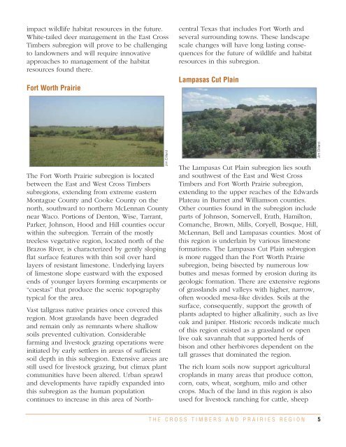
Fort Worth Prairie<br />
central Texas that <strong>in</strong>cludes Fort Worth <strong>and</strong><br />
several surround<strong>in</strong>g towns. These l<strong>and</strong>scape<br />
scale changes will have long last<strong>in</strong>g consequences<br />
for <strong>the</strong> future of wildlife <strong>and</strong> habitat<br />
resources <strong>in</strong> this subregion.<br />
Lampasas Cut Pla<strong>in</strong><br />
The Fort Worth Prairie subregion is located<br />
between <strong>the</strong> East <strong>and</strong> West <strong>Cross</strong> <strong>Timbers</strong><br />
subregions, extend<strong>in</strong>g from extreme eastern<br />
Montague County <strong>and</strong> Cooke County on <strong>the</strong><br />
north, southward to nor<strong>the</strong>rn McLennan County<br />
near Waco. Portions of Denton, Wise, Tarrant,<br />
Parker, Johnson, Hood <strong>and</strong> Hill counties occur<br />
with<strong>in</strong> <strong>the</strong> subregion. Terra<strong>in</strong> of <strong>the</strong> mostly<br />
treeless vegetative region, located north of <strong>the</strong><br />
Brazos River, is characterized by gently slop<strong>in</strong>g<br />
flat surface features with th<strong>in</strong> soil over hard<br />
layers of resistant limestone. Underly<strong>in</strong>g layers<br />
of limestone slope eastward with <strong>the</strong> exposed<br />
ends of younger layers form<strong>in</strong>g escarpments or<br />
“cuestas” that produce <strong>the</strong> scenic topography<br />
typical for <strong>the</strong> area.<br />
Vast tallgrass native prairies once covered this<br />
region. Most grassl<strong>and</strong>s have been degraded<br />
<strong>and</strong> rema<strong>in</strong> only as remnants where shallow<br />
soils prevented cultivation. Considerable<br />
farm<strong>in</strong>g <strong>and</strong> livestock graz<strong>in</strong>g operations were<br />
<strong>in</strong>itiated by early settlers <strong>in</strong> areas of sufficient<br />
soil depth <strong>in</strong> this subregion. Extensive areas are<br />
still used for livestock graz<strong>in</strong>g, but climax plant<br />
communities have been altered. Urban sprawl<br />
<strong>and</strong> developments have rapidly exp<strong>and</strong>ed <strong>in</strong>to<br />
this subregion as <strong>the</strong> human population<br />
cont<strong>in</strong>ues to <strong>in</strong>crease <strong>in</strong> this area of North-<br />
Jim Dillard<br />
The Lampasas Cut Pla<strong>in</strong> subregion lies south<br />
<strong>and</strong> southwest of <strong>the</strong> East <strong>and</strong> West <strong>Cross</strong><br />
<strong>Timbers</strong> <strong>and</strong> Fort Worth Prairie subregion,<br />
extend<strong>in</strong>g to <strong>the</strong> upper reaches of <strong>the</strong> Edwards<br />
Plateau <strong>in</strong> Burnet <strong>and</strong> Williamson counties.<br />
O<strong>the</strong>r counties found <strong>in</strong> <strong>the</strong> subregion <strong>in</strong>clude<br />
parts of Johnson, Somervell, Erath, Hamilton,<br />
Comanche, Brown, Mills, Coryell, Bosque, Hill,<br />
McLennan, Bell <strong>and</strong> Lampasas counties. Most of<br />
this region is underla<strong>in</strong> by various limestone<br />
formations. The Lampasas Cut Pla<strong>in</strong> subregion<br />
is more rugged than <strong>the</strong> Fort Worth Prairie<br />
subregion, be<strong>in</strong>g bisected by numerous low<br />
buttes <strong>and</strong> mesas formed by erosion dur<strong>in</strong>g its<br />
geologic formation. There are extensive regions<br />
of grassl<strong>and</strong>s <strong>and</strong> valleys with higher, narrow,<br />
often wooded mesa-like divides. Soils at <strong>the</strong><br />
surface, consequently, support <strong>the</strong> growth of<br />
plants adapted to higher alkal<strong>in</strong>ity, such as live<br />
oak <strong>and</strong> juniper. Historic records <strong>in</strong>dicate much<br />
of this region existed as a grassl<strong>and</strong> or open<br />
live oak savannah that supported herds of<br />
bison <strong>and</strong> o<strong>the</strong>r herbivores dependent on <strong>the</strong><br />
tall grasses that dom<strong>in</strong>ated <strong>the</strong> region.<br />
The rich loam soils now support agricultural<br />
cropl<strong>and</strong>s <strong>in</strong> many areas that produce cotton,<br />
corn, oats, wheat, sorghum, milo <strong>and</strong> o<strong>the</strong>r<br />
crops. Much of <strong>the</strong> l<strong>and</strong> <strong>in</strong> this region is also<br />
used for livestock ranch<strong>in</strong>g for cattle, sheep<br />
Jim Dillard<br />
THE CROSS TIMBERS AND PRAIRIES REGION<br />
5