

philips catalogue 2008 - British Cartographic Society
philips catalogue 2008 - British Cartographic Society
philips catalogue 2008 - British Cartographic Society

You also want an ePaper? Increase the reach of your titles
YUMPU automatically turns print PDFs into web optimized ePapers that Google loves.
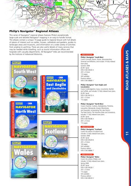
Philip’s Navigator ® Regional Atlases<br />
This series of Navigator ® regional atlases features Philip’s exceptionally<br />
large-scale and detailed Navigator ® mapping in an easy-to-handle format.<br />
The atlases contain a unique 15-page guide to regional leisure with full details<br />
of places of interest such as castles, houses, cathedrals and gardens, guides to<br />
landscape areas and museums, and information on a wide variety of activities<br />
from angling to yachting. There are also useful details of many services that<br />
may be needed while travelling, such as tourist information offices and<br />
hospitals with casualty departments. All Navigator ® titles are recommended<br />
by the Institute of Advanced Motorists.<br />
NEW EDITION<br />
Philip’s Navigator ® South West<br />
Covers Cornwall, Devon, Dorset, Gloucestershire,<br />
Somerset and Wiltshire, and includes 14 fully indexed<br />
town plans.<br />
Summer <strong>2008</strong><br />
£6.99 Spiral<br />
978 0 540 09330 4<br />
297 x 212mm<br />
112 pages<br />
Still available:<br />
Previous edition<br />
978 0 540 08680 1<br />
Philip’s Navigator ® East Anglia and<br />
Lincolnshire<br />
Covers Cambridgeshire, Essex, Lincolnshire, Norfolk<br />
and Suffolk, and includes 13 fully indexed town plans.<br />
£6.99 Spiral<br />
978 0 540 08155 4<br />
297 x 212mm<br />
112 pages<br />
Philip’s Navigator ® North West<br />
Covers Cheshire, Cumbria, Denbighshire, Flintshire,<br />
Lancashire, Merseyside, Greater Manchester,<br />
and Gwynedd, incorporating The Lake District,<br />
The Peak District, The Yorkshire Dales and Snowdonia.<br />
Includes 11 fully indexed town plans.<br />
£6.99 Spiral<br />
978 0 540 08296 4<br />
297 x 212mm<br />
112 pages<br />
NEW EDITION<br />
Philip’s Navigator ® Scotland<br />
Covers the whole of Scotland and<br />
includes 13 fully indexed town plans.<br />
Summer <strong>2008</strong><br />
£6.99 Spiral<br />
978 0 540 09329 8<br />
297 x 212mm<br />
144 pages<br />
Still available:<br />
Previous edition<br />
978 0 540 08886 7<br />
Philip’s Navigator ® NEW EDITION<br />
Wales<br />
Covers the whole of Wales and<br />
includes 14 fully indexed town plans.<br />
Spring <strong>2008</strong><br />
£6.99 Spiral<br />
978 0 540 09328 1<br />
297 x 212mm<br />
112 pages<br />
Still available:<br />
Previous edition<br />
978 0 540 08529 3