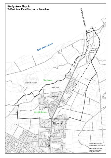
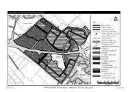
<strong>Study</strong> <strong>Area</strong> Map 1: <strong>Belfast</strong> <strong>Area</strong> <strong>Plan</strong> <strong>Study</strong> <strong>Area</strong> Boundary Northern Motorway Waimakariri River Chaneys Industrial <strong>Area</strong> Clearwater Resort The Groynes S293 <strong>Area</strong> Northwood <strong>Belfast</strong> Supa Centa South Island Trunk Railway Line Styx Mill Reserve Redwood Main North Road
4.0. AREA CONTEXT AND DESCRIPTION 4.1. The <strong>Study</strong> <strong>Area</strong> (See: <strong>Study</strong> <strong>Area</strong> Map 1). <strong>Belfast</strong> lies to the north of <strong>Christchurch</strong> on the periphery of the urban area, separated from <strong>Christchurch</strong> <strong>City</strong> by the Styx River corridor and remnant rural land. The southern boundary of the study area runs along Styx Mill Road and then continues eastwards just north of Farquhars Road until it reaches the proposed alignment of the Northern Arterial. The eastern boundary follows this road corridor from the north of Redwood, up to Guthries Road, then along Marshland Road until it reaches the South Island Main Trunk railway line. The boundary follows the line northwards to the Waimakariri River. The Western boundary starts from the Northern Motorway and follows the river terrace and stop bank running southwest, adjacent to the Otukaikino Stream, then south down Gardiners Road back to Styx Mill Road. Rural land also borders <strong>Belfast</strong> to the north, east and west. The Groynes Reserve and Clearwater Golf Resort lie to the north west between <strong>Belfast</strong> and the Waimakariri River. The study area is covered by <strong>Belfast</strong> and Brooklands/Spencerville Neighbourhood Maps 2 . 4.2. Development History The Styx River catchment is understood to have held many sites of significance to Maori. The area was important for food gathering and various families were given responsibility for the management and harvesting of the different plant and animal species. Many of these family associations continue to this day. Early settlers purchased land in the area as early as 1854. By 1881 the settlement had become known as <strong>Belfast</strong> and the following year the Canterbury Frozen Meat company was established. The railway line was opened in 1872. The township continued to grow as an important industrial area and a main thoroughfare to the north. The surrounding rural land in addition to being an agricultural and dairying district was, by the 1950’s, producing a large amount of 2 <strong>Christchurch</strong> <strong>City</strong> <strong>Council</strong>, Neighbourhood Maps, Policy and <strong>Plan</strong>ning Team, Winter 2006 fruit. A period of rapid residential growth occurred in the 1950’s, more subdivisions were developed between the 1960’s and 70’s and major residential development has taken place in recent years. 4.3. Housing A wide range of housing now exists within the study area, mostly free standing properties. Older lower cost housing is concentrated in north <strong>Belfast</strong> and in the apex between Main North Road and Johns Road. Houses are generally single storey and section sizes are mainly around 1000m², except in the few cases where they have been subdivided. There are a number of clusters of small attached units, some of which are <strong>Council</strong> owned. Newer subdivisions of standard suburban one and two-storey houses on sections averaging around 650m² have been developed adjacent to these original housing areas. The more recent subdivisions south of Englefield Road, including Northwood and Styx Mill contain a wider range of house types, ranging from small villas for the over 50’s to large 5 bedroom two storey properties. There is a corresponding range of section sizes, starting at around 250m², but even the largest properties are on sections of only around 1000m². The general trend, as is the case elsewhere in the city, appears to be for larger houses on smaller sections. In the rural area are a number of houses on large blocks of land, these comprise older, smaller, traditional rural dwellings and newer, substantial lifestyle properties. Entrance to Sheldon Park 4.4. Parks, open spaces and waterways The two largest parks within the built-up area are Sheldon Park in the centre of <strong>Belfast</strong>, which was established in 1912 12