Belfast Area Plan - Urban Design Study - Christchurch City Council
Belfast Area Plan - Urban Design Study - Christchurch City Council
Belfast Area Plan - Urban Design Study - Christchurch City Council

Create successful ePaper yourself
Turn your PDF publications into a flip-book with our unique Google optimized e-Paper software.
7.0 ADDRESSING THE<br />
ISSUES<br />
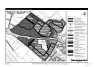
7.1. Community Identity<br />
The <strong>Area</strong> Development <strong>Plan</strong> offers the<br />
opportunity to introduce measures<br />
designed to retain and strengthen the<br />
sense of community identity enjoyed by<br />
the <strong>Belfast</strong> community.<br />
Currently <strong>Belfast</strong> is physically separate<br />
from the rest of <strong>Christchurch</strong>. It is<br />
surrounded by rural land to the north, east<br />
and west. To the south is a ‘green gap’<br />
that separates <strong>Belfast</strong> from the urban<br />
area. The free-standing nature of <strong>Belfast</strong><br />
contributes to its recognition as a place.<br />
With the urbanisation of rural land it is<br />
likely that <strong>Belfast</strong> will become physically<br />
attached to the rest of <strong>Christchurch</strong>, to the<br />
south and west. It will therefore be<br />
important to retain some sense of<br />
separateness through other means.<br />
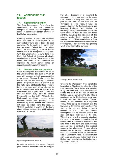
7.1.1. Sense of arrival and departure<br />
When travelling into <strong>Belfast</strong> from the south<br />
the Styx overbridge and then a stretch of<br />
road with greenery on both sides, provides<br />
a real sense of leaving Redwood and the<br />
rest of the city and travelling to another<br />
place. The point of arrival in <strong>Belfast</strong> is at<br />
the traffic lights at Radcliffe Road – where<br />
there is a clear and abrupt change to<br />
urban development with the entrance to<br />
Northwood and supermarket on the left<br />
and the bulky, busy, colourful <strong>Belfast</strong><br />
Supa-centa on the right. Although the<br />
Northwood subdivision begins some<br />
distance before this gateway, it is<br />
screened by a solid shelter belt and does<br />
not read as urban from the road. A<br />
‘<strong>Belfast</strong>’ road sign is located on the berm<br />
about midway between Styx Mill Road and<br />
Northward Boulevard.<br />
Approaching <strong>Belfast</strong> from the south<br />
In order to maintain this sense of arrival<br />
(and sense of departure when travelling in<br />
the other direction) it is important to<br />
safeguard this green corridor in some<br />
form. While it is likely that, the northern<br />
part of the land to the east will be<br />
developed at some stage, it would be<br />
possible to retain the illusion of a rural gap<br />
between Redwood and <strong>Belfast</strong> by<br />
ensuring that any development on the site<br />
were screened from the road by dense<br />
planting, including the retention of the<br />
existing shelter belt. Housing at the<br />
southern end of Northwood close to Styx<br />
Mill Road is currently visible and needs to<br />
be screened. There is some new planting<br />
which should serve this purpose.<br />
Arriving in <strong>Belfast</strong> from the north<br />
Crossing the Waimakariri River signals the<br />
beginning of <strong>Christchurch</strong>, when travelling<br />
from the north. Some distance is travelled<br />
along the green corridor of the motorway<br />
before the start of the built-up area of<br />
<strong>Belfast</strong>, marking arrival in the city. This is<br />
confirmed by the <strong>Christchurch</strong> entry sign,<br />
located opposite the <strong>Belfast</strong> Tavern.<br />
<strong>Belfast</strong>, is not identified as a separate<br />
entity, there being no indication that the<br />
township of <strong>Belfast</strong> has been reached. The<br />
start to the city and <strong>Belfast</strong> is poorly<br />
defined at this point with ribbon<br />
development on the western side of the<br />
road and open rural land to the east.<br />
When travelling in the opposite direction,<br />
the urban area peters out and a view of<br />
mature trees in the central reservation and<br />
rural land to the north and east provides<br />
an open vista, in contrast to the confined<br />
space of the urban area. A more clearly<br />
defined start to the city could be created<br />
when development occurs on the eastern<br />
side of Main North Road. The <strong>Christchurch</strong><br />
sign could be relocated further north and a<br />
<strong>Belfast</strong> sign placed where the <strong>Christchurch</strong><br />
sign currently stands.<br />
17