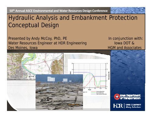
Hydraulic Analysis and Embankment Protection Conceptual Design
Hydraulic Analysis and Embankment Protection Conceptual Design
Hydraulic Analysis and Embankment Protection Conceptual Design

You also want an ePaper? Increase the reach of your titles
YUMPU automatically turns print PDFs into web optimized ePapers that Google loves.
50 th Annual ASCE Environmental <strong>and</strong> Water Resources <strong>Design</strong> Conference<br />
<strong>Hydraulic</strong> <strong>Analysis</strong> <strong>and</strong> <strong>Embankment</strong> <strong>Protection</strong><br />
<strong>Conceptual</strong> <strong>Design</strong><br />
Presented by Andy McCoy, PhD, PE In conjunction with:<br />
Water Resources Engineer at HDR Engineering Iowa DOT &<br />
Des Moines, Iowa HGM <strong>and</strong> Associates
Acknowledgements<br />
• Iowa DOT – Dave Claman, Bill Kaufman<br />
• HDR – Mike Schubert, Justin Anderson<br />
• HGM – Paul Kline, Brian Higginbotham
Introduction <strong>and</strong> Overview – Context<br />
• Record Missouri River flooding in 2011 – but<br />
also 2008 & 2010<br />
• I-680 severely damaged <strong>and</strong> rebuilt fall 2011<br />
• Iowa DOT investigating permanent<br />
embankment protection<br />
• <strong>Hydraulic</strong> implications of overtopping -typical<br />
sections
Presentation Overview<br />
• Damage Inspection at I-680<br />
• Study approach<br />
• <strong>Hydraulic</strong> analysis <strong>and</strong> results<br />
• <strong>Embankment</strong> protection ti concepts<br />
• Next steps – site specific design
Overview<br />
• Damage Inspection at I-680.<br />
• Study approach<br />
• <strong>Hydraulic</strong> analysis <strong>and</strong> results<br />
• <strong>Embankment</strong> protection ti concepts<br />
• Next steps – site specific design
Damage Investigation
Damage Investigation<br />
• Erosion most severe along the outside edges of the pavement<br />
• Severity of the erosion appeared to increase from north to south.<br />
• A majority of the embankment side slopes appeared to have remained<br />
intact<br />
• Isolated areas where the embankments were entirely breached
Overview<br />
• Damage Inspection at I-680.<br />
• Study approach<br />
• <strong>Hydraulic</strong> analysis <strong>and</strong> results<br />
• <strong>Embankment</strong> protection ti concepts<br />
• Next steps – site specific design
Study Approach<br />
• What type of embankment protection could be<br />
constructed on existing IaDOT roadway system<br />
where roadways subject to potential overtopping?<br />
• What range of maximum velocities result from<br />
varying headwater, tailwater, unit flow rate, typical<br />
section (4 lane versus 2 lane), <strong>and</strong> embankment<br />
height?<br />
• Could a design be developed that could be applied at<br />
multiple locations?
Study Approach<br />
• Analyze the hydraulics of typical IaDOT roadway<br />
sections over a range of conditions
Overview<br />
• Damage Inspection at I-680<br />
• Study approach<br />
• <strong>Hydraulic</strong> analysis <strong>and</strong> results<br />
• <strong>Embankment</strong> protection ti concepts<br />
• Next steps – site specific design
<strong>Hydraulic</strong> <strong>Analysis</strong> <strong>and</strong> Results - Overview<br />
• USBR 2D flow solver – SRH-2D<br />
• Created typical models for 2-lane <strong>and</strong> 4-lane<br />
roadway configuration<br />
• Varied parameters:<br />
Table 1. Combinations for modeling<br />
Roadway Tailwater (ft) Unit Flow Rate <strong>Embankment</strong><br />
Combinations (cfs/ft) Height (ft)<br />
2 Lane 2 to 8 5 to 40 2 to 7<br />
4 Lane 2 to 8 5 to 40 2 to 7<br />
• Looked at resultant maximum velocities<br />
• Combine information into useful figure to<br />
inform future decisions
<strong>Hydraulic</strong> <strong>Analysis</strong> <strong>and</strong> Results - Mesh<br />
Modeled Roadway <strong>and</strong> <strong>Embankment</strong> in<br />
plan view - 4 Lane Divided Highway –<br />
Contours. Crest Elevation = 991,<br />
Floodplain Elevation = 983 ft.<br />
Computational Mesh - Modeled<br />
Roadway <strong>and</strong> <strong>Embankment</strong>. The inset<br />
area shows the refined mesh in the<br />
area of the road embankment.
<strong>Hydraulic</strong> <strong>Analysis</strong> <strong>and</strong> Results – Water <strong>and</strong><br />
<strong>Embankment</strong> Profile
<strong>Hydraulic</strong> <strong>Analysis</strong> <strong>and</strong> Results – Maximum<br />
Velocity Versus Head Differential<br />
Maximum Velocity versus Head differential for all<br />
simulations. Note the area within the black oval<br />
represent the estimated conditions for I-680 for the<br />
flood experienced in 2011.
<strong>Hydraulic</strong> <strong>Analysis</strong> <strong>and</strong> Results – Conclusions<br />
• In 4-Lane – downstream embankment provides shielding for<br />
the upstream embankment<br />
• Maximum velocities are 14 - 18 feet per second (fps) as the unit<br />
flow rates <strong>and</strong> the head differential between upstream <strong>and</strong><br />
downstream increase<br />
• Secondary maximum velocity at downstream shoulder of the<br />
upstream embankment (4 – 9 fps)<br />
• Maximum velocity <strong>and</strong> maximum velocity location depends on<br />
degree of submergence but near edge of pavement to further<br />
down slope in low tailwater condition
Overview<br />
• Damage Inspection at I-680<br />
• Study approach<br />
• <strong>Hydraulic</strong> analysis <strong>and</strong> results<br />
• <strong>Embankment</strong> protection ti concepts<br />
• Next steps – site specific design
<strong>Embankment</strong> <strong>Protection</strong> Concepts<br />
• Vegetated Cover – The majority of existing IaDOT embankments are currently protected<br />
with a vegetated ttd grass cover. This option would consist it of maintaining ti i the existing iti<br />
embankment protection, which would provide protection against lower estimated flow<br />
velocities <strong>and</strong> short flood durations.<br />
•<br />
• Reinforced Vegetation – Permanent turf reinforcement mats like those manufactured by<br />
North American Green ® , Scourstop ® , <strong>and</strong> Green Armor System ® can be incorporated for<br />
higher estimated flow velocities.
<strong>Embankment</strong> <strong>Protection</strong> Concepts<br />
d k i l i i l i bl k b<br />
• Hard Armor –Rock riprap, concrete slope paving, or articulating concrete blocks can be<br />
placed along the embankment slopes with a geotextile.
<strong>Embankment</strong> <strong>Protection</strong> Concepts<br />
• Reinforced Vegetation/Hard Armor –Geoweb ® slope protection is a geosynthetic web<br />
filled with crushed aggregate, which h allows for vegetative ti growth, representing a<br />
combination of both hard armor <strong>and</strong> reinforced vegetation.
<strong>Embankment</strong> <strong>Protection</strong> Concepts<br />
Vegetated<br />
Cover Reinforced Vegetation Hard Armor<br />
Reinforced<br />
Vegetation/<br />
Hard Armor<br />
Grass Cover<br />
(Seeding)<br />
North<br />
American<br />
Green<br />
Scourstop<br />
Green<br />
Armor<br />
System<br />
Rip-Rap<br />
Articulating<br />
Concrete Block<br />
Slope<br />
Paving<br />
Geoweb<br />
Max Permissible<br />
Velocity (fps)<br />
3.5 to 8 (1) 25 21 fps 20 5 to 18 (1) >18 fps (1) >18 (1) 10 to 26.5<br />
<strong>Design</strong> Life<br />
Very Long<br />
Short<br />
(3 yr)<br />
Medium to<br />
Medium to<br />
Medium to Long<br />
Long<br />
long<br />
Long<br />
long (50+ yr) (50+ yr)<br />
(25+ yr)<br />
(25+ yr)<br />
Long<br />
(50+ yr)<br />
Maintenance<br />
Considerations<br />
Mowing<br />
Mowing<br />
No mowing,<br />
must spray<br />
Mowing<br />
Crack<br />
sealing<br />
No Mowing<br />
Mowing<br />
Constructability Easy Easy Medium Medium Difficult Medium/ Difficult<br />
Material Availability High High<br />
Depends on<br />
Area<br />
High<br />
High<br />
High (2 Iowa<br />
Distributors)<br />
Construction Cost<br />
Low to<br />
Medium (2)<br />
Medium<br />
Medium ($9-<br />
10/sf)<br />
Medium High (2) High High<br />
Medium (2) to<br />
High<br />
Maintenance Cost Low (2) May require periodic reseeding. Low (2) Low Low Low (2)<br />
Notes:<br />
• Reference (Fischenich, 2001)<br />
• Reference (IDNR, 2006)
<strong>Embankment</strong> <strong>Protection</strong> Concepts –<br />
What could work at I-680?<br />
Vegetated<br />
Cover Reinforced Vegetation Hard Armor<br />
Reinforced<br />
Vegetation/<br />
Hard Armor<br />
Grass Cover<br />
(Seeding)<br />
North<br />
American<br />
Green<br />
Scourstop<br />
Green<br />
Armor<br />
System<br />
Rip-Rap<br />
Articulating<br />
Concrete Block<br />
Slope<br />
Paving<br />
Geoweb<br />
Max Permissible<br />
Velocity (fps)<br />
3.5 to 8 (1) 25 21 fps 20 5 to 18 (1) >18 fps (1) >18 (1) 10 to 26.5<br />
<strong>Design</strong> Life<br />
Very Long<br />
Short<br />
(3 yr)<br />
Medium to<br />
Medium to<br />
Medium to Long<br />
Long<br />
long<br />
Long<br />
long (50+ yr) (50+ yr)<br />
(25+ yr)<br />
(25+ yr)<br />
Long<br />
(50+ yr)<br />
Maintenance<br />
Considerations<br />
Mowing<br />
Mowing<br />
No mowing,<br />
must spray<br />
Mowing<br />
Crack<br />
sealing<br />
No Mowing<br />
Mowing<br />
Constructability Easy Easy Medium Medium Difficult Medium/ Difficult<br />
Material Availability High High<br />
Depends on<br />
Area<br />
High<br />
High<br />
High (2 Iowa<br />
Distributors)<br />
Construction Cost<br />
Low to<br />
Medium (2)<br />
Medium<br />
Medium ($9-<br />
10/sf)<br />
Medium High (2) High High<br />
Medium (2) to<br />
High<br />
Maintenance Cost Low (2) May require periodic reseeding. Low (2) Low Low Low (2)<br />
Notes:<br />
• Reference (Fischenich, 2001)<br />
• Reference (IDNR, 2006)
<strong>Embankment</strong> <strong>Protection</strong> Concepts –<br />
Conclusions<br />
• The most practical embankment slope protection alternative -<br />
maximum protection/lowest life cycle cost for long stretches of<br />
existing roadway pavements <strong>and</strong> embankment<br />
• Required maintenance comparable to that of the existing grass<br />
cover<br />
• Reinforced Vegetation/Hard Armor alternative (Geoweb ® ) is<br />
recommended for areas with estimated velocities in excess of<br />
10 fps (I-680)<br />
• For areas with estimated flow velocities between 5 <strong>and</strong> 10 fps<br />
the Reinforced Vegetation alternative is recommended.<br />
• For areas with estimated velocities below 5 fps, a typical<br />
vegetated (grass) cover is recommended
Overview<br />
• Damage Inspection at I-680<br />
• Study approach<br />
• <strong>Hydraulic</strong> analysis <strong>and</strong> results<br />
• <strong>Embankment</strong> protection ti concepts<br />
• Next steps – site specific design
Next Steps-challenges <strong>and</strong> direction at I-680<br />
• Interstate 680 already reconstructed<br />
• Construction of hard armor/reinforced vegetation<br />
very challenging<br />
g<br />
• How to positively connect geoweb <strong>and</strong> navigate<br />
subdrain?
Next Steps-challenges <strong>and</strong> direction at I-680<br />
• Construction of hard armor/reinforced vegetation very challenging<br />
• Create structural embankment protection within ROW (levee) to<br />
protect shoulder <strong>and</strong> embankment toe<br />
• Eases construction challenges reduces high velocities at shoulder<br />
• Eases construction challenges, reduces high velocities at shoulder,<br />
riprap could be used for downstream protection, downstream slope<br />
could be shallower (~less velocity)
Next Steps-challenges <strong>and</strong> direction at I-680<br />
• No flow measurements taken at I-<br />
680 during flood – hard to estimate<br />
unit flow rate or overtopping flow<br />
quantity<br />
• Roadway was wet, but where was<br />
the flow concentrated<br />
• Where did flow break out of main<br />
channel, what role did levees <strong>and</strong><br />
road embankments play in<br />
directing the flow?<br />
• Need site specific 2D model
Next Steps-challenges <strong>and</strong> direction at I-680<br />
• Previously thought that<br />
situation didn’t occur<br />
with downstream side of<br />
embankment dry<br />
• IaDOT desires site<br />
IaDOT desires site<br />
specific 2D hydraulic<br />
model capable of<br />
answering the questions<br />
raised
Thank You.<br />
Questions?