tropical weather discussion - National Hurricane Center - NOAA
tropical weather discussion - National Hurricane Center - NOAA
tropical weather discussion - National Hurricane Center - NOAA

Create successful ePaper yourself
Turn your PDF publications into a flip-book with our unique Google optimized e-Paper software.
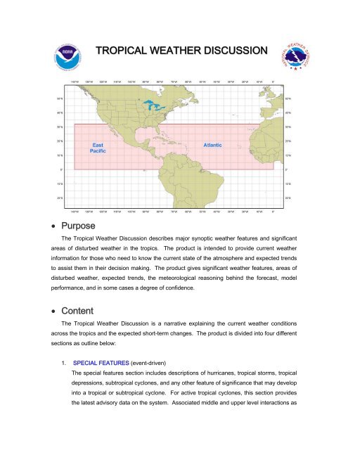
TROPICAL WEATHER DISCUSSION<br />
• Purpose<br />
The Tropical Weather Discussion describes major synoptic <strong>weather</strong> features and significant<br />
areas of disturbed <strong>weather</strong> in the tropics. The product is intended to provide current <strong>weather</strong><br />
information for those who need to know the current state of the atmosphere and expected trends<br />
to assist them in their decision making. The product gives significant <strong>weather</strong> features, areas of<br />
disturbed <strong>weather</strong>, expected trends, the meteorological reasoning behind the forecast, model<br />
performance, and in some cases a degree of confidence.<br />
• Content<br />
The Tropical Weather Discussion is a narrative explaining the current <strong>weather</strong> conditions<br />
across the tropics and the expected short-term changes. The product is divided into four different<br />
sections as outline below:<br />
1. SPECIAL FEATURES (event-driven)<br />
The special features section includes descriptions of hurricanes, <strong>tropical</strong> storms, <strong>tropical</strong><br />
depressions, sub<strong>tropical</strong> cyclones, and any other feature of significance that may develop<br />
into a <strong>tropical</strong> or sub<strong>tropical</strong> cyclone. For active <strong>tropical</strong> cyclones, this section provides<br />
the latest advisory data on the system. Associated middle and upper level interactions as
well as significant clouds and convection are discussed with each system. This section is<br />
omitted if none of these features is present.<br />
2. TROPICAL WAVES (event-driven)<br />
This section provides a description of the strength, position, and movement of all <strong>tropical</strong><br />
waves analyzed on the surface analysis, from east to west. A brief reason for a wave’s<br />
position is usually given, citing surface observations, upper air time sections, satellite<br />
imagery, etc. The associated convection is discussed with each <strong>tropical</strong> wave as well as<br />
any potential impacts to landmasses or marine interests. This section is omitted if there<br />
are no <strong>tropical</strong> waves present.<br />
3. ITCZ<br />
In this section, the Inter<strong>tropical</strong> Convergence Zone (ITCZ) is depicted by coordinates<br />
from east to west with an outline of all associated convection referenced to the axis, if<br />
possible. The ITCZ is depicted based on the following definition: “a zonally elongated<br />
axis of surface wind confluence in the tropics, due to confluence of northeasterly and<br />
southeasterly trade winds, and/or confluence at the poleward extent of cross-equatorial<br />
flow into a near-equatorial ‘heat trough’ or ‘monsoon trough.’”<br />
4. DISCUSSION<br />
The <strong>discussion</strong> section makes reference to middle and upper level features and provides<br />
connection to how these features are interacting with or influencing surface features.<br />
Convection is outlined with the features as warranted. This section will also provide<br />
short-term (up to 48 hours) trends and forecasts of features, especially if they are<br />
forecast to strengthen and/or affect landmasses. A <strong>discussion</strong> of model guidance may<br />
also be included. In general, this section is regionalized according to the current <strong>weather</strong><br />
pattern (i.e. Gulf of Mexico, Caribbean, Western Atlantic, etc.)<br />
Coverage and intensity for convective and non-convective <strong>weather</strong> is defined as follows:<br />
COVERAGE FOR CONVECTIVE and NON-CONVECTIVE WEATHER:<br />
Numerous Widespread >54%<br />
Scattered Areas 25% - 54%<br />
Widely scattered Local/Locally
INTENSITY OF CONVECTION (based on cloud top temperatures):<br />
Strong < -70°C (summer) < -60°C (winter)<br />
Moderate between -45°C and -70°C (summer) between -35°C and -60°C (winter)<br />
Weak > -45°C (summer) > -35°C (winter)<br />
• Coverage<br />
The <strong>National</strong> <strong>Hurricane</strong> <strong>Center</strong> issues two Tropical Weather Discussions, as shown below:<br />
1. Atlantic<br />
From the equator to 32°N west of the prime meridian including the Caribbean Sea, Gulf of<br />
Mexico, and adjacent land areas. These areas include the southeast United States<br />
[especially Florida], Mexico, Central America, northern South America, and western Africa<br />
2. East Pacific<br />
From the equator to 32°N east of 140°W including coastal areas of Mexico, and Central and<br />
South America.<br />
• Issuance / Transmission<br />
The Tropical Weather Discussion is transmitted under World Meteorological Organization (WMO)<br />
and <strong>NOAA</strong> Weather Wire Services (NWWS) headers as shown below:<br />
WMO<br />
NWWS<br />
Atlantic AXNT20 KNHC MIATWDAT<br />
East Pacific AXPZ20 KNHC MIATWDEP<br />
Tropical Weather Discussions are issued on a regular six hourly schedule as shown below:<br />
Issuance Time<br />
MIATWDAT 105 AM EST<br />
(205 AM EDT)<br />
705 AM EST<br />
(805 AM EDT)<br />
105 PM EST<br />
(205 PM EDT)<br />
705 PM EST<br />
(805 PM EDT)<br />
MIATWDEP 0405 UTC 1005 UTC 1605 UTC 2205 UTC