ROWing Through Fall Creek - Butler University
ROWing Through Fall Creek - Butler University
ROWing Through Fall Creek - Butler University

You also want an ePaper? Increase the reach of your titles
YUMPU automatically turns print PDFs into web optimized ePapers that Google loves.
e looked at include trashcans, benches, water fountains, art installations, waste receptacles for dogs, and<br />
community centers (gardens, parks, farms, town hall, etc.). A visual survey of the MFC area will be used for<br />
gathering this data. Each amenity will be counted and assessed for condition. From this data it will then be<br />
determined what areas need the most work and attention.<br />
CONNECTIVITY:<br />
The class defines connectivity as the relationships, beliefs and accessibility one has in relation to the waterways<br />
within Indianapolis. The goal of the Connectivity element is the idea of a “10-minute walk” or a<br />
“20-minute bike ride”.<br />
For the connectivity element, the class will decide how realistic it would be for people to reach the waterways<br />
in terms of safety. The metric used will be a risk assessment. The class will focus on factors that will have an<br />
impact on resident’s connection to the water, such as sidewalk accessibility, safety and pedestrian lighting.<br />
A safety rating will be established through a physical survey from 0 - 5 based on sidewalk conditions, lighting,<br />
and Complete Streets criteria. Complete Streets include sidewalks, bike lanes or paved shoulders, safe<br />
crossing opportunities, median island, accessible pedestrian signals, and curb extensions (Smart Growth<br />
America, 2010). Maps will be provided to show where the safest routes currently are and where trouble areas<br />
are that should be improved.<br />
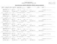
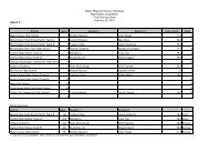
Following the completion of the Complete Streets analysis, numerous problem areas were identified in the<br />
Mapleton <strong>Fall</strong> <strong>Creek</strong> Neighborhood. To conduct the analysis, sidewalk conditions, lighting, curb extensions,<br />
buffer areas, bike lanes, and bus lanes, were all analyzed. The group picked seven target locations and at<br />
these locations rated each of these conditions on a scale of 1 through 5. A rating of 5 was excellent, while<br />
a rating of zero meant none were found. Bike lanes, bus lanes, and curb extensions were a main concern as<br />
the group found none in the area. An average for the other three focus areas was calculated in order to give<br />
an overall idea of how well the neighborhood was doing as a whole in these aspects. Sidewalk conditions<br />
rated the highest at a 3.7. Next were buffer areas at 1.57 and lastly lighting with only a 1. A more detailed<br />
analysis can be found in Figure 1, which gives the ratings by target location and condition.<br />
The data analyzed by the class thus far indicates the streets are middle to low quality in terms of being considered<br />
a complete street. The sidewalks are in the overall best condition, but many were found to be narrow<br />
and very close to the street where cars drive. Many street crossings painted on the ground have faded.<br />
Lighting is also a concern because the neighborhood lacks pedestrian lighting that could be used to make the<br />
sidewalks safer when walking at night and late afternoon. Bus and bike lanes are the biggest problem for the<br />
neighborhood. The lack of these lanes makes this a very difficult form of transportation for neighborhood<br />
residents. Improving these aspects will improve connectivity by making the neighborhood safer and more<br />
accessible.<br />
The class will also examine the number of access points to the river within a given stretch of land. This will<br />
help serve as a representation of whether or not the community members are able to easily and safely access<br />
the river within a reasonable distance from their home.<br />
The metric the class will use to measure this is counting and documenting the number of access points along<br />
<strong>Fall</strong> <strong>Creek</strong> that are available to the public. Along with the quantitative measurement of this element, there<br />
will be a qualitative measurement. The class will document what type of access point each is, its location<br />
and amount of accessibility. In addition, factors that will make it a better access point for the community<br />
and ways of increasing safety for the community members will be documented.<br />
7<br />
Environmental Practicum :: <strong>Fall</strong> 2012