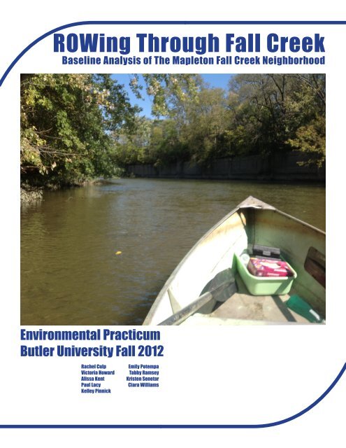
ROWing Through Fall Creek - Butler University
ROWing Through Fall Creek - Butler University
ROWing Through Fall Creek - Butler University

You also want an ePaper? Increase the reach of your titles
YUMPU automatically turns print PDFs into web optimized ePapers that Google loves.
<strong>ROWing</strong> <strong>Through</strong> <strong>Fall</strong> <strong>Creek</strong><br />
Baseline Analysis of The Mapleton <strong>Fall</strong> <strong>Creek</strong> Neighborhood<br />
Environmental Practicum<br />
<strong>Butler</strong> <strong>University</strong> <strong>Fall</strong> 2012<br />
Rachel Culp<br />
Victoria Howard<br />
Alissa Kent<br />
Paul Lacy<br />
Kelley Pinnick<br />
Emily Potempa<br />
Tabby Ramsey<br />
Kristen Senetar<br />
Ciara Williams
Reconnecting To Our Waterways<br />
Table of Contents<br />
I. Introduction<br />
• History of R.O.W.<br />
• Project Overview<br />
• Problem Statement<br />
• Mapleton <strong>Fall</strong> <strong>Creek</strong> Neighborhood<br />
II. Evaluation & Results<br />
• Aesthetics<br />
• Connectivity<br />
• Ecology<br />
III. Summary<br />
• Recommendations<br />
IV. Figures and Graphics<br />
• Figures<br />
• Maps<br />
• Honey Suckle Stem Ratio Infographic<br />
• Aesthetics Survey Infographic<br />
• Transportation Infographic<br />
• Knowledge Assessment<br />
• Housing Aesthetics Infographic<br />
V. Appendices<br />
• IRB Letter<br />
• Aesthetics Survey<br />
VI. References
<strong>ROWing</strong> through <strong>Fall</strong> <strong>Creek</strong><br />
I. Introduction<br />
History of R.O.W.<br />
Over the past decade, Indianapolis has joined a growing number of cities that have become more aware<br />
of the environment and its impact on the way people live. The Livability Challenge in 2010 jump-started<br />
Indianapolis on the path to improve many environmental aspects of the city, including its waterways.<br />
Due to old infrastructure, Indianapolis faces a major problem with its combined sewage outflow (CSO)<br />
system. Its design causes Indianapolis’s CSO system to overflow into its water supply nearly every time it<br />
rains (Sabalow). While pollution on Earth has been increasing each year, public education about wildlife<br />
habitats, ecosystems and waterways has not (Worldometers). This lack of education has contributed to<br />
the general public not understanding where their water comes from. Indianapolis has effectively turned<br />
its back on the waterways. As a result, Indianapolis has created a problem that can wait no longer to be<br />
fixed. With no general understanding of watersheds, connectedness among Indianapolis’s waterways<br />
or the importance of healthy water, how will the city successfully improve its water quality and quality<br />
of life for the citizens of Indianapolis? Indianapolis community members have modified the Livability<br />
Challenge previously in place and created the Reconnecting to Our Waterways initiative (R.O.W). The<br />
focus of R.O.W is not to just unveil the waterways that have been lost over the course of Indianapolis’s<br />
growth as a city, but also to help the community reconnect to these waterways.<br />
The R.O.W. initiative grew out of the Livability Challenge sponsored by CEOs for Cities. The Livability<br />
Challenge asked cities to provide “access to art, good design, and nature every day” (CEOs for Cities).<br />
One of the initiatives that came out of the Livability Challenge was to reconnect to the White River<br />
in Indianapolis. Around the same time as the Livability Challenge, the Indianapolis Museum of Art<br />
commissioned an installation called “Flow: Can You See the River?” by artist Mary Miss (Indianapolis<br />
Museum of Art). This art installation increased consciousness of the White River in Indianapolis and<br />
spurred multiple neighborhood efforts to improve the watersheds. Indianapolis was ready to give back<br />
to its waterways and R.O.W. was born. R.O.W. is a grassroots movement involving multiple partners<br />
throughout the city who are interested in revitalizing the river (R.O.W.). It is not simply focused on improving<br />
the water quality itself, but takes a holistic approach to improving the waterways in Indianapolis<br />
and making the city more livable by highlighting watershed health and natural beauty.<br />
Project Overview<br />
The main purpose of R.O.W. is to promote safety, well-being, beauty, connectivity, pride, and respect<br />
within our communities. Six elements were designed to accomplish this: Aesthetics, Connectivity, Ecology,<br />
Economics, Safety, and Well-Being. These elements were thought to be most beneficial to the community,<br />
both now and in the future. The class worked with three of these elements: Connectivity, Aesthetics,<br />
and Ecology. When it comes to connectivity, the goal is for the neighborhood to have better<br />
access to their waterways. The idea is in a 10 minute walk or 20 minute bike ride from anywhere in the<br />
community that will bring residents to the waterway and to different destination points. Some factors<br />
that could influence the resident’s ability to do this are the existence of sidewalks and pedestrian lighting,<br />
all of which encompass what is called “Complete Streets”. For the second element, aesthetics, the<br />
goal is to provide art, nature, and beauty every day for everyone. Right now, many neighborhoods do not<br />
have access to this. The last element, ecology, will deal with a wide variety of things. It is already known<br />
how polluted the waterways are and what negative effects Combined Sewage Overflows (CSO) have on<br />
them. However, there are other things we can do to improve the ecological conditions in the area. Tree<br />
planting, invasive species removal, water quality, and educating people about the waterways will all go<br />
into improving the ecology.<br />
4
Problem Statement<br />
In every neighborhood, residents are part of a large watershed. Watersheds are complex systems that every<br />
community within Indianapolis is connected to. The water from your house runs into a local river and that<br />
river ultimately runs off into larger bodies of water and ends in oceans. The Indianapolis watershed flows<br />
into the Mississippi River. However, one problem is that many residents do not know how watersheds work,<br />
nor how their individual actions can affect the water. R.O.W.’s goal is to help educate people about this and<br />
how they can help to improve their actions and behaviors to benefit the water.<br />
The environmental practicum will investigate the three elements, providing input to the R.O.W. committee<br />
and ultimately leading to the development of metrics that allow for tracking progress towards the ultimate<br />
goals, which will also be set by the class. In addition, the members of the environmental practicum will give<br />
a unique perspective to the R.O.W. project, as young-adult community members are a large focus area for<br />
the project. The findings of the environmental practicum will be presented to the R.O.W. committee upon<br />
completion of the course.<br />
The Reconnecting to Our Waterways initiative is focusing on six areas of the river: West Indianapolis &<br />
Near Westside, Mid-North & <strong>Fall</strong> <strong>Creek</strong>, Lafayette Square & Eagle <strong>Creek</strong>, Midtown & Central Canal, Near<br />
Eastside & Pogue’s Run, and Southeast & Pleasant Run (R.O.W.). The environmental practicum will focus<br />
on the Mid-North and <strong>Fall</strong> <strong>Creek</strong> neighborhoods.<br />
Mapleton <strong>Fall</strong> <strong>Creek</strong> Neighborhood<br />
The Mapleton <strong>Fall</strong> <strong>Creek</strong> neighborhood (MFCN) is bordered by <strong>Fall</strong> <strong>Creek</strong> Parkway Drive on the east and<br />
south, 38th Street to the north, and Meridian Street to the west. As of 2010, this area was 1.32 square miles<br />
with 7,057 residents. Of those 7,057 residents, 5,556 were over the age of eighteen years. There were 3,168<br />
total households within the area. Minorities accounted for 5,263 residents at that time. In regards to income,<br />
1,202 households claimed their income to fall between $25,000 and $49,999. This was the most common<br />
choice among the income distribution. Although, 223 households had public assistance income and 226<br />
households claimed their income to be $100,000+, being the high and low ends of the spectrum. There were<br />
249 families living in poverty in the neighborhood and of those 249, 179 were families in poverty with related<br />
children under the age of eighteen. Education statistics backed the income statistics of the time. While<br />
there were no high school dropouts, in 2010, 1,623 of the residents possessed a high school diploma. 1, 143<br />
residents possessed a bachelor’s degree. Of the 7,057 residents in 2010, 1,337 residents had obtained their<br />
associates degree. In total, there were 4,571 housing units in the MFCN. Of these 4,571 housing units, 1,403<br />
housing units were vacant. Owned properties accounted for 1,125 housing units, while rented properties accounted<br />
for 2,043. In 2010, property crime accounted for 64.75% of all crime, while the remaining 35.25%<br />
was attributed to violent crimes and simple assaults. (SAVI.org)<br />
5<br />
Environmental Practicum :: <strong>Fall</strong> 2012
<strong>ROWing</strong> through <strong>Fall</strong> <strong>Creek</strong><br />
II. Evaluation & Results<br />
AESTHETICS:<br />
Aesthetics is inclusive of both art and design. It involves the use of natural beauty to create a visually<br />
pleasing environment. This element integrates man-made design with natural design and art.<br />
Aesthetics is the idea of beauty for every person, every day by restoring the natural beauty and using<br />
art installations to enhance the community.<br />
The class will assess the character of the neighborhood and how cohesive it is. Neighborhood character<br />
will be based not only on how cohesive the neighborhood is within the area, but within the<br />
neighborhood as a whole. It is the hope that the rich history of Mapleton-<strong>Fall</strong> <strong>Creek</strong> be preserved<br />
through its architecture and its neighborhood buildings.<br />
The class will look at over 100 houses that fall within the Mapleton-<strong>Fall</strong> <strong>Creek</strong> area. Analysis of the<br />
neighborhood will include gas stations, schools, grocery options, churches and a few other components.<br />
Figure 3 shows the proportional correspondence between these neighborhood attributes.<br />
Churches, bus stops and apartment complexes have the highest prominence within the community.<br />
There are 14 churches, 60 bus stops and 10 apartment complexes. There is a lack of food options in<br />
this specific area. The class discovered in the MFC neighborhood there is one grocery store and 5<br />
fast food and take out restaurants. There is a farmer’s market along 38th Street, but this market has<br />
limited options and is not a consistent source of produce and food.<br />
The class found, when looking at neighborhood character, there are very similar characteristics<br />
among the houses and neighborhoods. The major area of focus was based on a square area extending<br />
west to east streets of College Ave and Central and the north and south between 34th Street and<br />
29th Street. However, MFCN as a whole was studied, with the triangular boundaries of 38th Street,<br />
Meridian Street and <strong>Fall</strong>s <strong>Creek</strong>. The class drove from street to street analyzing the neighborhood<br />
characters, as well as taking pictures of the various houses. It was found that there is consistency<br />
within the MFCN on the use of vibrant colors. No two houses are designed the exact same, however<br />
they collectively created a cohesive aesthetic unique to historical MFC. The data sheet consists of<br />
looking at factors such as how many resources are available as well as the house styles that appear<br />
in the neighborhood.<br />
The metric for aesthetics will be a survey that will be given to members of the MFCN community.<br />
The survey will assess opinions on how visually pleasing areas surrounding the waterway appear to<br />
be, in addition to what factors influence the community members most when it comes to visiting the<br />
area.<br />
The results of the aesthetics survey show several trends in the members of the MCFN community.<br />
Most residents only visit the <strong>Fall</strong> <strong>Creek</strong> waterway area for recreational purposes on occasion. It can<br />
also be seen from the survey results that most MFCN residents feel resting areas and parks are in the<br />
biggest need for improvement.<br />
The third metric that will be used for aesthetics is an inventory of amenities. Natural beauty arising<br />
from the waterway and nature is very important, but there is another factor, amenities can also<br />
be used to increase the visual appeal of an area. Several things will be determined including what<br />
amenities are present, how many are there, and what condition they are in. The amenities that will<br />
6
e looked at include trashcans, benches, water fountains, art installations, waste receptacles for dogs, and<br />
community centers (gardens, parks, farms, town hall, etc.). A visual survey of the MFC area will be used for<br />
gathering this data. Each amenity will be counted and assessed for condition. From this data it will then be<br />
determined what areas need the most work and attention.<br />
CONNECTIVITY:<br />
The class defines connectivity as the relationships, beliefs and accessibility one has in relation to the waterways<br />
within Indianapolis. The goal of the Connectivity element is the idea of a “10-minute walk” or a<br />
“20-minute bike ride”.<br />
For the connectivity element, the class will decide how realistic it would be for people to reach the waterways<br />
in terms of safety. The metric used will be a risk assessment. The class will focus on factors that will have an<br />
impact on resident’s connection to the water, such as sidewalk accessibility, safety and pedestrian lighting.<br />
A safety rating will be established through a physical survey from 0 - 5 based on sidewalk conditions, lighting,<br />
and Complete Streets criteria. Complete Streets include sidewalks, bike lanes or paved shoulders, safe<br />
crossing opportunities, median island, accessible pedestrian signals, and curb extensions (Smart Growth<br />
America, 2010). Maps will be provided to show where the safest routes currently are and where trouble areas<br />
are that should be improved.<br />
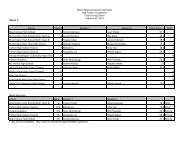
Following the completion of the Complete Streets analysis, numerous problem areas were identified in the<br />
Mapleton <strong>Fall</strong> <strong>Creek</strong> Neighborhood. To conduct the analysis, sidewalk conditions, lighting, curb extensions,<br />
buffer areas, bike lanes, and bus lanes, were all analyzed. The group picked seven target locations and at<br />
these locations rated each of these conditions on a scale of 1 through 5. A rating of 5 was excellent, while<br />
a rating of zero meant none were found. Bike lanes, bus lanes, and curb extensions were a main concern as<br />
the group found none in the area. An average for the other three focus areas was calculated in order to give<br />
an overall idea of how well the neighborhood was doing as a whole in these aspects. Sidewalk conditions<br />
rated the highest at a 3.7. Next were buffer areas at 1.57 and lastly lighting with only a 1. A more detailed<br />
analysis can be found in Figure 1, which gives the ratings by target location and condition.<br />
The data analyzed by the class thus far indicates the streets are middle to low quality in terms of being considered<br />
a complete street. The sidewalks are in the overall best condition, but many were found to be narrow<br />
and very close to the street where cars drive. Many street crossings painted on the ground have faded.<br />
Lighting is also a concern because the neighborhood lacks pedestrian lighting that could be used to make the<br />
sidewalks safer when walking at night and late afternoon. Bus and bike lanes are the biggest problem for the<br />
neighborhood. The lack of these lanes makes this a very difficult form of transportation for neighborhood<br />
residents. Improving these aspects will improve connectivity by making the neighborhood safer and more<br />
accessible.<br />
The class will also examine the number of access points to the river within a given stretch of land. This will<br />
help serve as a representation of whether or not the community members are able to easily and safely access<br />
the river within a reasonable distance from their home.<br />
The metric the class will use to measure this is counting and documenting the number of access points along<br />
<strong>Fall</strong> <strong>Creek</strong> that are available to the public. Along with the quantitative measurement of this element, there<br />
will be a qualitative measurement. The class will document what type of access point each is, its location<br />
and amount of accessibility. In addition, factors that will make it a better access point for the community<br />
and ways of increasing safety for the community members will be documented.<br />
7<br />
Environmental Practicum :: <strong>Fall</strong> 2012
<strong>ROWing</strong> through <strong>Fall</strong> <strong>Creek</strong><br />
This metric found two stoplights, five crosswalks and two parking lots within the area of study. These<br />
numbers reflect a lack of connectivity between the community and waterways of Indianapolis. <strong>Fall</strong> <strong>Creek</strong><br />
Parkway is not pedestrian friendly, making stoplights and crosswalks more important for the safety of the<br />
MFCN residents.<br />
A third metric the class will use for connectivity is the community’s general awareness of and relationship<br />
with the river. Aspects of this metric will analyze and asses the community’s awareness of their physical<br />
proximity to the waterway, the awareness of their impact on water conditions, and their awareness of what<br />
role the river plays in their daily lives.<br />
To measure the community’s connectivity to their waterway, surveys that address these conditions will be<br />
conducted. Having an understanding the current conditions will create a baseline from which ROW can<br />
improve upon.<br />
The data from the behavioral and attitudes survey shows several over-arching trends that could be useful to<br />
ROW. The results, within the sample population, suggest that very few people know the current status of<br />
water quality in <strong>Fall</strong> <strong>Creek</strong>. The results also suggest that the sample population does not know where the<br />
water they use and drink on a daily basis comes from.<br />
ECOLOGY:<br />
Ecology is a broad element that relates to species, water quality and general habitat. R.O.W. will improve the<br />
physical, chemical and biological measures of water quality.<br />
The class will perform a stream assessment along <strong>Fall</strong> <strong>Creek</strong>. The assessment data sheet includes various<br />
questions related to the overall composition and condition of the stream. The Reach Level Assessment is<br />
composed of rating conditions such as water clarity, shading and wildlife. The final reach accessibility consists<br />
of a rating of 1-5 as well as determining if the stream environment is good, fair or difficult.<br />
The class will look at three different stretches of <strong>Fall</strong> <strong>Creek</strong> and perform a Unified Stream Assessment for<br />
each section. During the assessment, different attributes of the river will be analyzed, including habitat,<br />
vegetation, banks, erosion, and floodplain, as seen in Figures 3 - 6. This shows the results from each of the<br />
<strong>Fall</strong> <strong>Creek</strong> sections.<br />
Overall, the conditions of the sections sampled are suboptimal; two of the sections have this rating, while<br />
the third has a rating of marginal. The 38th Street bridge to the Monon has an overall score of 87, the area<br />
from the Monon to the 30th Street bridge has a score of 94, and the 30th Street bridge to Central Avenue<br />
area has a score of 74, all out of a possible 160 points.<br />
As the <strong>Fall</strong> <strong>Creek</strong> waterway flows closer to downtown Indianapolis, the condition of the river decreases.<br />
This could be due to many factors. The most probable factor, and also the most detrimental, is the result<br />
from human activities. As the river flows and the neighborhood becomes more encroached with residents<br />
and urban settings, the implications and effects on the river also increases. The increase in human activities<br />
and settlements has led to an increase in erosion on the river banks and also to a less spacious buffer area<br />
between the river and residential areas. With the more populous areas surrounding the river, it greatly affects<br />
the health of the river and the quality of its water.<br />
The class will develop a metric to measure the amount of honeysuckle cover there is in the <strong>Fall</strong> <strong>Creek</strong> cor-<br />
8
idor. Honeysuckle is an invasive plant in Indiana and throughout the states. It is in many cases creates a<br />
monoculture by choking out all other native plants. Honeysuckle hurts ecosystems in that it diminishes native<br />
plants and hurts plant species diversity. It outcompetes natives by growing quickly and growing tall. It<br />
shades other understory species and is spread easily by birds, which enjoy its red berries.<br />
The honeysuckle metric is aimed at providing a base measure for honeysuckle coverage before any removal<br />
interventions are established. The numbers of honeysuckle stems in sixteen-five by three yards plots were<br />
counted. Eight of these plots were in a section of <strong>Fall</strong> <strong>Creek</strong> that is not maintained in any way. The other<br />
eight were in a section that is a designated as park area and is maintained by invasive species removal and<br />
herbicide application.<br />
The honeysuckle stem count was much greater in the non-maintained section of <strong>Fall</strong> <strong>Creek</strong>, compared to<br />
the maintained section. The honeysuckle in this area is abundant and covers most of the other vegetation.<br />
In the maintained section, there is almost no honeysuckle cover, but there is also not much other understory<br />
vegetation. It appears that the methods used in order to diminish honeysuckle cover may have also diminished<br />
native species in the area.<br />
The final metric that will be used to assess ecology is a water quality assessment. This will take into consideration<br />
a combination of factors that influence water quality. The class contacted the Marion County Health<br />
Department, who compiles water quality tests that have been conducted over the past five months along the<br />
Mapleton/<strong>Fall</strong> <strong>Creek</strong> sector.<br />
The water quality assessment for <strong>Fall</strong> <strong>Creek</strong> includes the total dissolved solids, dissolved oxygen, nitrates,<br />
and E.coli samples. The total dissolved solids of a river is a good indication of the health of that river, but<br />
in this case, it may be difficult to conclude results solely from this factor because there are a number of combined<br />
sewage overflow sites along this sector of the River, which will have a major impact on our test results.<br />
If there is an excess of total dissolved solids, it may be too dense and difficult for sunlight to penetrate the<br />
water and reach plants at the bottom, thus preventing photosynthesis from happening. If there is a lack of<br />
total dissolved solids in the water, it is possible for too much sunlight to penetrate the water and excel photosynthesis<br />
to an unhealthy level, and also increase the temperature of the water, which adversely affects all<br />
organisms in the water. Total dissolved solids are often introduced to the <strong>Creek</strong> through runoff, lawn fertilizer,<br />
animal waste, and soil erosion.<br />
E.coli is typically introduced to the <strong>Creek</strong> by animal waste, and human waste when the combined sewer<br />
overflows are opened during periods of heavy rain. E.coli is a bacterium that can cause illness and death if<br />
not treated. It is important for recreational walkers to pick up animal waste along the <strong>Creek</strong> in order to avoid<br />
or decrease the introduction of E.coli into the <strong>Creek</strong>. It is especially important to understand the E.coli levels<br />
in <strong>Fall</strong> <strong>Creek</strong>, in order to inform the public when and when not to visit the <strong>Creek</strong> or go near the water.<br />
Typically, the E.coli levels will be higher after a rainfall and if the CSO system is active (EPA).<br />
Dissolved oxygen varies seasonally, such that cold water holds more and warm water holds less. Dissolved<br />
oxygen is extremely important for the survival of plants and animals living in the <strong>Creek</strong>. If there is not<br />
enough dissolved oxygen in the water, it may indicate that not enough photosynthesis is occurring, which<br />
means other organisms in the water are not able to maintain sufficient oxygen to survive, and they can literally<br />
suffocate. Most static bodies of water maintain a healthy amount of dissolved oxygen because the<br />
movement of the water draws in oxygen. However, the CSO system in the MFCN emits many undesirable<br />
pollutants into the <strong>Creek</strong>, and those pollutants often use the oxygen in the water, leaving very little for the<br />
9 Environmental Practicum :: <strong>Fall</strong> 2012
<strong>ROWing</strong> through <strong>Fall</strong> <strong>Creek</strong><br />
native species of the <strong>Creek</strong> (EPA).<br />
Nitrates are essential plant nutrients, but in excess, can cause water quality problems. As mentioned above,<br />
many pollutants that enter the <strong>Creek</strong> can suck the oxygen out of the water. Nitrates are an example of<br />
such a pollutant, often introduced to the water from lawn fertilizers. Excess nitrates can cause hypoxia, or<br />
dangerously low levels of dissolved oxygen. When combined with phosphates, excess nitrates can cause<br />
dangerously high acceleration of plant growth, especially phytoplankton, which may change the availability<br />
of nutrients in the water for other organisms. This process is sometimes referred to as eutrophication, or<br />
unnatural aging of a body of water. Combined sewer overflows are a source of excess nitrates that enter the<br />
<strong>Creek</strong>, from runoff, lawn chemicals, and animal waste (EPA).<br />
10
III. Summary<br />
Recommendations<br />
AESTHETICS:<br />
For the future, R.O.W. and other community organizations will focus on providing more easily accessible<br />
resources for the MFCN residents. There will be more consideration of how neighborhoods are designed<br />
and what resources can be found in that area. The class found that there is a lack of yard space and space between<br />
houses. It is important for neighbors to interact with one another. However there should also be some<br />
sense of privacy and personal space. Aesthetics begins to overlap with complete the streets in some areas, but<br />
looking at yard space, the majority of houses are within a few feet from the street. This is not an ideal design,<br />
especially for families with children as safety is important--noise levels increase and risk also increases. One<br />
area R.O.W. will focus on is increasing sidewalk width, sidewalk buffers and the distance between the street<br />
and the houses. In addition, R.O.W. will continue rehabbing homes in the MFCN area, and will continue to<br />
stay true to their historical styles. The houses in MFC are more modern but they continue to resemble the<br />
houses that were first built in MFC. See Figure 2.<br />
The Mapleton <strong>Fall</strong> <strong>Creek</strong> Development Corporation has begun to rehab homes and the homes that have<br />
been rehabbed are greatly increasing the pleasing look of the neighborhood. R.O.W. will consider putting<br />
a program into place that involves volunteers or workers who work to rehab a projected amount of homes<br />
during the year. These aspects will create a more social and interactive community. It will draw other communities<br />
to visit the MFCN area. It is then that R.O.W. will incorporate the connectivity element to encourage<br />
interaction, enjoyment and appreciation of the waterway.<br />
R.O.W. will put effort towards increasing the number of rest areas along the walkways. In addition, lighting<br />
along the pathways will be increased. The areas along the waterway will continue to be maintained, but<br />
education about the benefits of maintaining an area will also be provided to the MFCN residents. As these<br />
improvements are made, residents will become more open and comfortable with the idea of visiting the<br />
waterway area on a more regular basis.<br />
The MFCN will greatly benefit from an increased number of amenities. There are currently many areas in<br />
the MFCN that have little to no public amenities. Many of the current amenities are deteriorated to the point<br />
that they actually do more harm for the area than good. There are trash cans present that make the area look<br />
run down. Installation of new trashcans and benches will both serve to give people places to sit and throw<br />
their trash away as well as make the area look newer and well maintained. It will also be beneficial for water<br />
fountains and waste receptacles for dogs to be installed in parks to help promote kids playing and people<br />
walking their dogs. Another observation made was the vast number of vacant homes. These vacant lots have<br />
a greater likelihood of having trash littered in the yards, as well as having overgrown lots. By increasing the<br />
number of trashcans in these areas it will be possible to help decrease the amount of trash littered on these<br />
abandoned lots. It was apparent that the area has deteriorated over time, the amenities present were a very<br />
good source of that observation. By replacing or re-facing the current amenities and adding more the overall<br />
feel of the neighborhood would be lifted from deteriorating to up-and-coming.<br />
11 Environmental Practicum :: <strong>Fall</strong> 2012
<strong>ROWing</strong> through <strong>Fall</strong> <strong>Creek</strong><br />
CONNECTIVITY:<br />
The results of the Complete Streets analysis show a great need for improvement in the Mapleton <strong>Fall</strong> <strong>Creek</strong><br />
area in order to improve connectivity. The analysis shows the area is heavily lacking in lighting, curb extensions,<br />
bus, and bike lanes. R.O.W. will work to improve connectivity by improving or adding these features<br />
to the community. The lighting found in the community is all street lighting and there are no path lights<br />
for pedestrians. Curb extensions will also make it safer for people to cross streets and will encourage more<br />
walking. Bus and bike lanes, while not as feasible to implement, will also greatly improve connectivity and<br />
encourage use. R.O.W. will not put their resources into improving sidewalks, as they are in pretty good condition.<br />
Instead, R.O.W. will focus on making the community safer by implementing curb extensions and<br />
pedestrian lighting. They will also work to provide bike and bus lanes. Incorporating these aspects into the<br />
neighborhood will improve connectivity.<br />
Due to the lack of crosswalks and stoplights found in the focus area, R.O.W. will make effort to work with<br />
the city of Indianapolis to make <strong>Fall</strong> <strong>Creek</strong> Parkway and surrounding areas more pedestrian friendly. Increasing<br />
the number of crosswalks will improve pedestrian and driver safety. It will also make residents more<br />
likely to visit the waterway area.<br />
The survey of MFCN residents shows many people do not know where their water comes from. Increasing<br />
people’s awareness on the source of their water will have a positive effect on the quality of that source. If<br />
people knew where their water comes from and know the effect they have on it, they will treat that source<br />
more respectfully.<br />
A question the survey asked was, “Would you be interested in learning more about your relationship with<br />
<strong>Fall</strong> <strong>Creek</strong>?” It appears that the sample population is overwhelmingly interested in learning more. Moving<br />
forward, it will be the responsibility of R.O.W. to use this information and to decide whether providing this<br />
knowledge to the <strong>Fall</strong> <strong>Creek</strong> community will be beneficial to the R.O.W. initiative.<br />
ECOLOGY:<br />
The results from the Stream Assessment show that the three sections of <strong>Fall</strong> <strong>Creek</strong> that were sampled are at<br />
least of marginal conditions and quality. There are also some areas of the river that are suboptimal. Overall,<br />
the condition of the river is in good shape and offers potential to be revived into a thriving waterway, for both<br />
human use and for habitats for wildlife and plant life.<br />
A major way to improve the river is to expand the buffer areas surrounding the river. This will limit the<br />
amount of human activities near the water, mostly by residential living areas, and will reduce its harming<br />
effects on the water. By having R.O.W. reassess the condition and quality of the water and make efforts to<br />
vitalize the surroundings, it will create an attraction for human interests and wildlife populations.<br />
Manual honeysuckle removal, followed by seeding of native species in order to encourage native species<br />
growth in the area, will be the most effective plan for R.O.W. This will allow for the discouragement of honeysuckle<br />
growth, while encouraging native species to grow in the same area.<br />
Based on data from the Marion County Health Department, it appears that the combined sewer overflows<br />
have an impact on the water quality, but it varies on a monthly basis, depending on rainfall. The results for<br />
E.coli are inconclusive at this point, because there is not enough data to compare a full year, and the levels<br />
appear to fluctuate randomly, or based on rainfall. The nitrate levels increase later in the year, possibly due<br />
12
to the drought over the summer, which caused levels to go down, and then rise with rainfall. It also appears<br />
that dissolved oxygen levels rise with the later months, possibly due to cooling temperatures, because dissolved<br />
oxygen is more prevalent in colder water. The total dissolved solids fluctuate similar to the E.coli, but<br />
the results are inconclusive.<br />
13 Environmental Practicum :: <strong>Fall</strong> 2012
Figure 1: Field Notes Neighborhood Character<br />
14
15<br />
Figure 2: Neighborhood Character Photos
R.O.W.<br />
Figure 3: Stream Assessemnet Worksheet A<br />
16
Figure 4: Stream Assessemnet Worksheet B
Figure 5: Stream Assessemnet Worksheet C<br />
18
19<br />
Figure 6: Stream Assessemnet Score Card
Figure 7: Study Area<br />
<br />
<br />
FocusArea:<br />
From38thStreettoInterstate65<br />
Neighborhoods:<br />
• Mapleton<strong>Fall</strong><strong>Creek</strong>:38 th StreettoMeridian<br />
• NearNorthside:Meridian,21 st ,Interstate65,<strong>Fall</strong><strong>Creek</strong><br />
• NearNWRiverside:Meridian,<strong>Fall</strong><strong>Creek</strong>,Dr.MLKJr.St.,and38 th St<br />
<br />
<br />
StreamLength:3.14miles(5,046meters)<br />
NumberofSamplingsites:<br />
• UnifiedStreamAssessment:5<br />
• HealthDepartmentWaterQualitysamplingsite:4<br />
<br />
20
Figure 8: Honeysuckle Ratios<br />
21
Figure 9: Survey Results: Increasing Visits<br />
22
23<br />
Figure 10: Survey Results: Accessing <strong>Fall</strong> <strong>Creek</strong>
Figure 11: Survey Results: Knowledge Assessment<br />
24
25<br />
Figure 12: Aesthetics
V. Appendices<br />
26
A. IRB Approval Letter<br />
INSTITUTIONAL REVIEW BOARD<br />
DATE: November 2, 2012<br />
TO: Rachel Culp, Marjorie Hennessy<br />
FROM: Joel Martin<br />
Chair, Institutional Review Board<br />
RE: IRB Protocol<br />
TITLE: Reconnecting to Our Waterways (ROW): <strong>Fall</strong> <strong>Creek</strong> Evaluation<br />
SUBMISSION TYPE: New Study<br />
On behalf of the Institutional Review Board (IRB), I am pleased to announce that your application for<br />
research involving human subjects has been approved as exempt as of the date of this memo. As<br />
such, there will be no further review of your protocol, and you are cleared to begin the procedures<br />
outlined in your protocol.<br />
As an exempt study, there is no requirement for continuing review. Your protocol will remain on file<br />
with the IRB as a matter of record. Although your study is exempt from a continuing review, you and<br />
your research team are not exempt from ethical research practices and should therefore employ all<br />
protections for your participants and their data which are appropriate to your project.<br />
Please note the following conditions apply to all IRB approvals:<br />
1. No subjects may be involved in any study procedure prior to the IRB approval date.<br />
2. All unanticipated or serious adverse events must be reported to the Institute for Research and<br />
Scholarship within 5 days.<br />
3. All protocol modifications must be IRB approved prior to implementation unless they are intended to<br />
reduce risk. This includes any change of investigator, or site address.<br />
4. All protocol deviations must be reported to the IRB within 5 working days.<br />
5. All recruitment materials and methods must be approved by the IRB prior to being used.<br />
I offer my congratulations on your approval and wish you success on your research. Should you desire<br />
additional assistance or clarification, please call me at 9971 or email jmmarti1@butler.edu.<br />
27
B. Aesthetics Survey<br />
The$results$of$this$survey$will$be$used$to$assess$community$member’s$visual$preference$for$<br />
the$area$surrounding$the$<strong>Fall</strong>$<strong>Creek</strong>$waterway$throughout$the$<strong>Fall</strong>$<strong>Creek</strong>$neighborhood.$<br />
1. Below$are$two$photos$of$the$area$along$the$<strong>Fall</strong>$<strong>Creek</strong>$waterway.$Circle$the$picture$<br />
you$like$most.$Why$do$you$like$that$picture$the$most?$<br />
_________________________________________________________________________________________________<br />
_________________________________________________________________________________________________$<br />
$<br />
$<br />
$ $ Picture$#1$ $ $ $ $ $ Picture$#2$<br />
$<br />
2. Circle$the$number$that$best$corresponds$to$your$feeling$about$the$picture$below.$<br />
$<br />
$<br />
$<br />
$<br />
$<br />
$<br />
1$ $ 2$ $ 3$ $ 4$ $ 5$<br />
Least$ $ $ $ $ $ $ $ Most$<br />
Desirable$ $ $ $ $ $ $ Desirable$<br />
$<br />
28
$<br />
$<br />
3. Circle$the$number$that$best$corresponds$to$your$feeling$about$the$picture$below.$<br />
$<br />
$<br />
$<br />
$<br />
$<br />
$<br />
$<br />
$<br />
$<br />
$<br />
$<br />
$<br />
$<br />
1$ $ 2$ $ 3$ $ 4$ $ 5$<br />
Least$ $ $ $ $ $ $ $ Most$<br />
Desirable$ $ $ $ $ $ $ Desirable$<br />
4. How$much$does$appearance$of$the$area$surrounding$the$<strong>Fall</strong>$<strong>Creek</strong>$waterway$<br />
impact$how$much$time$you$spend$doing$activities$new$it?$<br />
1$ $ 2$ $ 3$ $ 4$ $ 5$<br />
No$$ $ $ $$$$$$Neutral$ $ $ $ A$lot$<br />
Impact$ $ $ $ $ $<br />
5. On$average,$how$often$do$you$visit$the$<strong>Fall</strong>$<strong>Creek</strong>$waterway$area$for$recreational$<br />
purposes?$(Check$one)$<br />
Never$_____$<br />
Once$in$a$while$_____$<br />
Once$a$week$_____$<br />
Between$two$and$five$times$a$week$_____$<br />
Everyday$_____$<br />
6. What$would$make$you$more$likely$to$visit$the$area?$(Check$one)$<br />
Visually$appealing$(fewer$overgrown$areas,$etc.)$_____$<br />
Lighting$along$walking$path(s)$_____$<br />
Access$_____$<br />
Resting$areas/parks$along$the$walking$path$_____$<br />
Nothing$would$change$the$likelihood$of$me$visiting$_____$<br />
Other$(please$say$what$it$is)$_____$<br />
$<br />
29
7. Age$(4lease$check$one)$<br />
0$–$14$_____$<br />
15$–$24$_____$<br />
25$–$34$_____$<br />
35$–$44$_____$<br />
45$–$54$_____$<br />
55+$_____$<br />
Prefer$not$to$answer$_____$<br />
$<br />
8. Gender$(please$check$one)$<br />
Male$_____$<br />
Female$_____$<br />
Prefer$not$to$answer$_____$<br />
$<br />
9. Zip$code$__________$<br />
$<br />
10. Income$(Please$check$one)$<br />
$0$–$24,999$_____$<br />
$25,000$–$49,999$_____$<br />
$50,000$–$99,999$_____$<br />
$100,000+$_____$<br />
Prefer$not$to$answer_____$<br />
$<br />
$<br />
$<br />
http://www.esf.edu/es/via/futureofwetlands/6.pdf$<br />
$<br />
$<br />
$ $ $ $ $ $ $<br />
$<br />
$<br />
30
C. Behavior and Attitudes Survey<br />
Behavior & Attitudes Survey:<br />
1. How far do you live from <strong>Fall</strong> <strong>Creek</strong>? Very Far<br />
Far<br />
Close<br />
Very Close<br />
2. How many blocks do you live from the creek? # of blocks: _____<br />
3. How often do you visit the creek? Never<br />
Rarely<br />
Occasionally<br />
Often<br />
Very often<br />
4. If you visit the creek, how do you get there? Walk<br />
Bicycle<br />
Drive<br />
Other______________________________<br />
5. What activities do you perform while at the creek? Hiking<br />
Fishing<br />
Swimming<br />
Bird Watching<br />
Other ______________________________<br />
6. Do you know about the current status of water quality Yes<br />
in the creek?<br />
No<br />
7. Do you know where the water you drink and use on a Yes<br />
daily basis comes from?<br />
If yes, where? _______________________<br />
No<br />
8. Would you be interested in learning more about your Not interested<br />
relationship with the creek?<br />
Interested<br />
Very interested<br />
9. Gender Male<br />
Female<br />
10. Age _________________<br />
11. Zipcode _________________<br />
31
V. References<br />
CEOs for Cities. Livability Challenge. 2006-2012. 5 October 2012 .<br />
Indianapolis Museum of Art. FLOW: Can You See the River. 2012. 7 Oct 2012 .<br />
Marion County Health Department. (2012). <strong>Fall</strong> <strong>Creek</strong> Watershed. Retrieved 10 09, 2012,<br />
from Marion County Health Department Water Quality Sampling: http://www.mchd.com/<br />
wq/<strong>Fall</strong>Crek/Html/fck_h2o.htm<br />
R.O.W. Elements. 2012. 6 October 2012 .<br />
Sabalow, Ryan and Nichols, Mark. Sewage overflow pipes run into Indianapolis poor areas,<br />
near parks, schools. Indianapolis Star. Indianapolis, 27 September 2012.<br />
SAVI.org<br />
Smart Growth America. (2010). National Complete Streets Coalition - Fundamentals. Retrieved<br />
October 4, 2012, from Smart Growth America: http://www.smartgrowthamerica.<br />
org/complete-streets/complete-streets-fundamentals<br />
Worldometers. 6 October 2012 .<br />
32<br />
Environmental Practicum :: <strong>Fall</strong> 322012