SHLAA - 2012 UPDATE_FINAL(Low Res) - Allerdale Borough Council
SHLAA - 2012 UPDATE_FINAL(Low Res) - Allerdale Borough Council
SHLAA - 2012 UPDATE_FINAL(Low Res) - Allerdale Borough Council

You also want an ePaper? Increase the reach of your titles
YUMPU automatically turns print PDFs into web optimized ePapers that Google loves.
<strong>Allerdale</strong><br />
Local Plan<br />
Evidence Base<br />
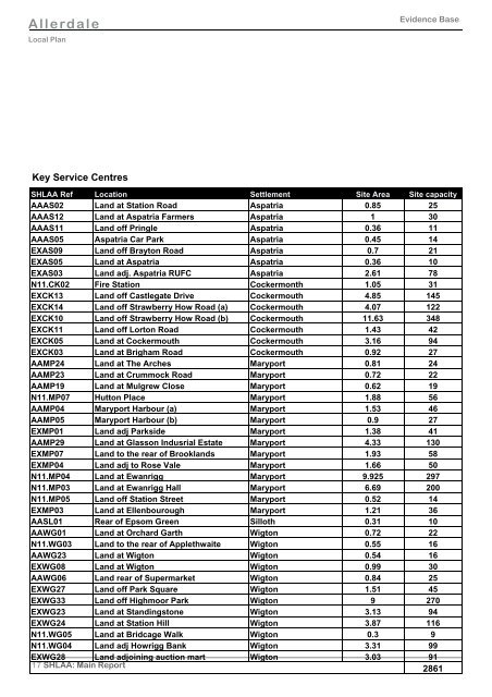
Key Service Centres<br />
<strong>SHLAA</strong> Ref Location Settlement Site Area Site capacity<br />
AAAS02 Land at Station Road Aspatria 0.85 25<br />
AAAS12 Land at Aspatria Farmers Aspatria 1 30<br />
AAAS11 Land off Pringle Aspatria 0.36 11<br />
AAAS05 Aspatria Car Park Aspatria 0.45 14<br />
EXAS09 Land off Brayton Road Aspatria 0.7 21<br />
EXAS05 Land at Aspatria Aspatria 0.36 10<br />
EXAS03 Land adj. Aspatria RUFC Aspatria 2.61 78<br />
N11.CK02 Fire Station Cockermonth 1.05 31<br />
EXCK13 Land off Castlegate Drive Cockermouth 4.85 145<br />
EXCK14 Land off Strawberry How Road (a) Cockermouth 4.07 122<br />
EXCK10 Land off Strawberry How Road (b) Cockermouth 11.63 348<br />
EXCK11 Land off Lorton Road Cockermouth 1.43 42<br />
EXCK05 Land at Cockermouth Cockermouth 3.16 94<br />
EXCK03 Land at Brigham Road Cockermouth 0.92 27<br />
AAMP24 Land at The Arches Maryport 0.81 24<br />
AAMP23 Land at Crummock Road Maryport 0.72 22<br />
AAMP19 Land at Mulgrew Close Maryport 0.62 19<br />
N11.MP07 Hutton Place Maryport 1.88 56<br />
AAMP04 Maryport Harbour (a) Maryport 1.53 46<br />
AAMP05 Maryport Harbour (b) Maryport 0.9 27<br />
EXMP01 Land adj Parkside Maryport 1.38 41<br />
AAMP29 Land at Glasson Indusrial Estate Maryport 4.33 130<br />
EXMP07 Land to the rear of Brooklands Maryport 1.93 58<br />
EXMP04 Land adj to Rose Vale Maryport 1.66 50<br />
N11.MP04 Land at Ewanrigg Maryport 9.925 297<br />
N11.MP03 Land at Ewanrigg Hall Maryport 6.69 200<br />
N11.MP05 Land off Station Street Maryport 0.52 14<br />
EXMP03 Land at Ellenbourough Maryport 1.21 36<br />
AASL01 Rear of Epsom Green Silloth 0.31 10<br />
AAWG01 Land at Orchard Garth Wigton 0.72 22<br />
N11.WG03 Land to the rear of Applethwaite Wigton 0.55 16<br />
AAWG23 Land at Wigton Wigton 0.54 16<br />
EXWG08 Land at Wigton Wigton 0.99 30<br />
AAWG06 Land rear of Supermarket Wigton 0.84 25<br />
EXWG27 Land off Park Square Wigton 1.51 45<br />
EXWG33 Land off Highmoor Park Wigton 9 270<br />
EXWG23 Land at Standingstone Wigton 3.13 94<br />
EXWG24 Land at Station Hill Wigton 3.87 116<br />
N11.WG05 Land at Bridcage Walk Wigton 0.3 9<br />
N11.WG04 Land adj Howrigg Bank Wigton 3.31 99<br />
EXWG28 Land adjoining auction mart Wigton 3.03 91<br />
17 <strong>SHLAA</strong>: Main Report<br />
2861