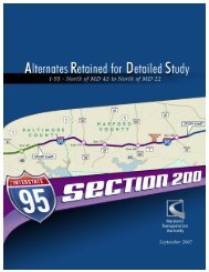
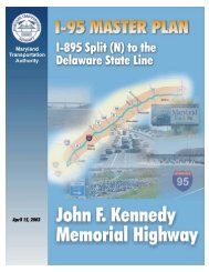
- Page 1: November2007
- Page 4 and 5: Figure S-1: Study Area Map D. Proje
- Page 6 and 7: GPL ETL • MD 152: Option 1 • MD
- Page 8 and 9: Table S-2. Communities/Right-of-Way
- Page 10 and 11: Table of Contents I. PURPOSE AND NE
- Page 12 and 13: Figure II-7. MD 543 Option 1 Figure
- Page 14 and 15: I. PURPOSE AND NEED A. Identificati
- Page 16 and 17: Figure I-1: Study Area Map C. Backg
- Page 18 and 19: areas within or connecting county-d
- Page 21 and 22: . Safety The accident rate for Sect
- Page 23: Table I-2. AM and PM Average Daily
- Page 27 and 28: equired to cross 3 or more general
- Page 29 and 30: This concept would provide good ove
- Page 31 and 32: No Build Interchange Analysis • I
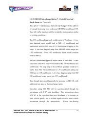
- Page 33 and 34: • Option 3: Single Point Urban Di
- Page 35 and 36: Analysis: • Option 1A provides th
- Page 37 and 38: Analysis: • Option 1 would mainta
- Page 39 and 40: Two through lanes would generally b
- Page 47 and 48: 3. Express Toll Lane Alternative Th
- Page 49 and 50: to the I-95 northbound ETLs. Two I-
- Page 56 and 57: F. Comparison of Alternatives The f
- Page 58 and 59: would be enhanced through a reducti
- Page 60 and 61: Table II-2. Estimated Travel Speeds
- Page 62 and 63: . MD 152 The future needs forecast
- Page 64 and 65: Figure II-16. MD 24 Park and Ride F
- Page 66 and 67: III. EXISTING ENVIRONMENT AND IMPAC
- Page 68 and 69: Executive Order 12898 defines minor
- Page 70 and 71: Table III-2: Population Statistics
- Page 72 and 73: Build Alternatives The Build Altern
- Page 74 and 75:
The study area consists of 7 commun
- Page 76 and 77:
Table III-4: Communities Located wi
- Page 78:
Table III-4: Communities Located wi
- Page 81 and 82:
communities could experience indire
- Page 83 and 84:
MD 24 Option 2 (Appendix A, Plates
- Page 85 and 86:
surrounding communities as the incr
- Page 87 and 88:
There are also some minor impacts t
- Page 89 and 90:
allow access to and from the ETLs v
- Page 91 and 92:
lanes, reduced median width, and th
- Page 93 and 94:
volumes and congestion increase thr
- Page 96 and 97:
c. Cemeteries In addition to the ce
- Page 98 and 99:
points at any of the postal facilit
- Page 100 and 101:
The Maryland Transit Administration
- Page 102 and 103:
1. Employment Characteristics Table
- Page 104 and 105:
geographic base of a particular bus
- Page 106 and 107:
would not be altered, aside from th
- Page 108 and 109:
543), and the areas both north and
- Page 110:
2. Effects on Land Use No-Build Alt
- Page 114 and 115:
The historic architecture APE for t
- Page 116 and 117:
an additional 5 land types (alluvia
- Page 118 and 119:
• Seeding, sodding, and stabilizi
- Page 120 and 121:
2. Aquatic Resources a. Surface Wat
- Page 122 and 123:
located within the southeast quadra
- Page 124 and 125:
• A permanent WUS impact would in
- Page 126 and 127:
The following highlights wetland im
- Page 128 and 129:
For an all-inclusive impact summary
- Page 130 and 131:
since this area was altered during
- Page 132 and 133:
BMPs would include stormwater manag
- Page 134 and 135:
year floodplains, 0.8 acres within
- Page 136 and 137:
Option 2, MD 543 Option 7, and MD 2
- Page 138 and 139:
General Purpose Lanes Alternative T
- Page 140 and 141:
impacts more LSTs due to its larger
- Page 142 and 143:
Table III-17. Alternative Impacts t
- Page 144 and 145:
The No-Build Alternative would have
- Page 146 and 147:
improvements, EPA’s MOBILE 6.2 em
- Page 148 and 149:
using this facility. Diesel trucks
- Page 150 and 151:
The EPA is the lead Federal Agency
- Page 152 and 153:
zoning or the development of guidel
- Page 154 and 155:
3. Exposure Levels and Health Effec
- Page 156 and 157:
cannot evaluate the validity of the
- Page 158 and 159:
NSA 07 consists of single family ho
- Page 160 and 161:
NSA 20 consists of single family re
- Page 162 and 163:
etween the hours of 6:00 AM and 6:0
- Page 164 and 165:
Table III-20. Short-term Noise Meas
- Page 166 and 167:
Table III-20. Short-term Noise Meas
- Page 168 and 169:
Table III-20. Short-term Noise Meas
- Page 170 and 171:
• Traffic flow conditions (volume
- Page 172 and 173:
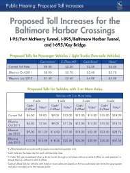
averaging. If the average cost per
- Page 174 and 175:
Table III-22 Predicted Noise Levels
- Page 176 and 177:
Table III-22 Predicted Noise Levels
- Page 178 and 179:
Table III-22 Predicted Noise Levels
- Page 180 and 181:
Table III-22 Predicted Noise Levels
- Page 182 and 183:
Table III-23. Summary of Noise Abat
- Page 184 and 185:
Table III-25. Noise Barrier ‘Cost
- Page 186 and 187:
The noise barrier investigated is l
- Page 188 and 189:
The noise barrier was optimized to
- Page 190 and 191:
Express Toll Lanes Alternative The
- Page 192 and 193:
NSA 23 The noise barrier investigat
- Page 194 and 195:
Express Toll Lanes Alternative The
- Page 196 and 197:
The No Build Alternative will not i
- Page 198 and 199:
area (the widening of I-95 from MD
- Page 201 and 202:
Active Agricultural Land Due to int
- Page 203 and 204:
cumulative impacts to floodplains w
- Page 205 and 206:
The indirect and cumulative effects
- Page 207 and 208:
IV. COORDINATION AND COMMENTS A. Fo
- Page 209 and 210:
The fifth Focus Group Meeting was h
- Page 211 and 212:
Finally, an update on the status of