Watershed Database and Mapping Projects: Hudson River (New York)
Watershed Database and Mapping Projects: Hudson River (New York)
Watershed Database and Mapping Projects: Hudson River (New York)

You also want an ePaper? Increase the reach of your titles
YUMPU automatically turns print PDFs into web optimized ePapers that Google loves.
NOAA’s National Ocean Service • Office of Response <strong>and</strong> Restoration<br />
<strong>Watershed</strong> <strong>Database</strong> <strong>and</strong> <strong>Mapping</strong> <strong>Projects</strong>/<strong>Hudson</strong> <strong>River</strong> (<strong>New</strong> <strong>York</strong>)<br />
Protection <strong>and</strong> restoration of<br />
coastal watersheds requires<br />
the synthesis of complex<br />
environmental issues.<br />
Contaminated site remediation,<br />
dredging <strong>and</strong> disposal of<br />
contaminated sediments, <strong>and</strong> restoring injured<br />
habitats are a few of the challenges facing<br />
coastal managers. The evaluation of multiple<br />
environmental issues can be significantly<br />
improved by combining scientific data <strong>and</strong><br />
watershed characteristics into a Geographic<br />
Information System (GIS). NOAA’s Assessment<br />
<strong>and</strong> Restoration Division (ARD) has developed<br />
decision-support tools for specific watersheds<br />
that combine the use of a st<strong>and</strong>ard database<br />
structure, database-mapping application (Query<br />
Manager/ MARPLOT ® ) <strong>and</strong> an ArcView ® GIS<br />
project (i.e., <strong>Watershed</strong> <strong>Database</strong> <strong>and</strong> <strong>Mapping</strong><br />
<strong>Projects</strong>). Sediment contaminant <strong>and</strong> toxicity<br />
<strong>and</strong> tissue data, natural resources, <strong>and</strong> potential<br />
habitat restoration projects can be overlaid<br />
on a watershed’s features <strong>and</strong> l<strong>and</strong> uses, <strong>and</strong><br />
displayed on maps at flexible spatial scales.<br />
This approach simplifies data analysis <strong>and</strong><br />
presentation, provides valuable tools for complex<br />
decision-making, <strong>and</strong> improves our underst<strong>and</strong>ing<br />
of dynamic aquatic ecosystems.<br />
NOAA has used this approach in several watersheds affected<br />
by contaminant releases from Superfund sites <strong>and</strong> other<br />
sources including <strong>New</strong>ark Bay, San Francisco Bay, Christina<br />
<strong>River</strong>, Sheboygan <strong>River</strong>, Puget Sound, <strong>and</strong> Calcasieu Estuary.<br />
These <strong>Watershed</strong> <strong>Projects</strong> use a st<strong>and</strong>ard structure along with<br />
information tailored to the major objectives of each watershed.<br />
For example, the <strong>New</strong>ark Bay <strong>Watershed</strong> Project supports<br />
decisions about remediation <strong>and</strong> disposal of contaminated<br />
sediment, while the San Francisco Bay <strong>Watershed</strong> Project focuses<br />
on Superfund site remediation <strong>and</strong> habitat restoration. The<br />
common organizational structure for data <strong>and</strong> spatial information<br />
promotes data sharing among Federal, state, <strong>and</strong> local agencies<br />
working within a watershed.<br />
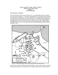
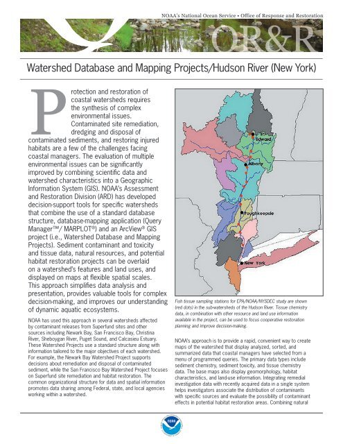
Fish tissue sampling stations for EPA/NOAA/NYSDEC study are shown<br />
(red dots) in the sub-watersheds of the <strong>Hudson</strong> <strong>River</strong>. Tissue chemistry<br />
data, in combination with other resource <strong>and</strong> l<strong>and</strong> use information<br />
available in the project, can be used to focus cooperative restoration<br />
planning <strong>and</strong> improve decision-making.<br />
NOAA’s approach is to provide a rapid, convenient way to create<br />
maps of the watershed that display analyzed, sorted, <strong>and</strong><br />
summarized data that coastal managers have selected from a<br />
menu of programmed queries. The primary data types include<br />
sediment chemistry, sediment toxicity, <strong>and</strong> tissue chemistry<br />
data. The base maps also display geomorphology, habitat<br />
characteristics, <strong>and</strong> l<strong>and</strong>-use information. Integrating remedial<br />
investigation data with recently acquired data in a single system<br />
helps investigators associate the distribution of contaminants<br />
with specific sources <strong>and</strong> evaluate the possibility of contaminant<br />
effects in potential habitat restoration areas. Combining natural
esource information <strong>and</strong> contaminant distributions across the<br />
watershed enhances the potential for successful restoration of wideranging<br />
populations. The <strong>Watershed</strong> <strong>Projects</strong> have benefited a variety<br />
of user groups <strong>and</strong> have enhanced cooperation <strong>and</strong> data sharing.<br />
ARD is developing the <strong>Hudson</strong> <strong>River</strong> <strong>Watershed</strong> Project, which<br />
includes the entire <strong>Hudson</strong> <strong>River</strong> Superfund site, over 200 river<br />
miles from the mouth of the river in <strong>New</strong> <strong>York</strong> Harbor to beyond<br />
<strong>Hudson</strong> Falls. Fish <strong>and</strong> sediments throughout the <strong>Hudson</strong> <strong>River</strong><br />
are contaminated with polychlorinated biphenyls (PCBs), forcing<br />
commercial <strong>and</strong> recreational fishing closures <strong>and</strong> advisories<br />
throughout the river.<br />
The project integrates sediment chemistry <strong>and</strong> tissue chemistry data<br />
from<br />
· EPA’s Superfund Reassessment Remedial Investigation;<br />
· The State of <strong>New</strong> <strong>York</strong>’s long-term monitoring of PCB <strong>and</strong> other<br />
contaminant concentrations in fish throughout the river;<br />
· General Electric’s investigations of sediment <strong>and</strong> fish;<br />
· NOAA’s studies of PCB levels in fish; <strong>and</strong><br />
· The U.S. Department of the Interior’s studies of PCB<br />
concentrations in treeswallow nestlings, eggs <strong>and</strong> prey<br />
organisms.<br />
The <strong>Hudson</strong> <strong>River</strong> <strong>Watershed</strong> Project’s objective is to provide state<br />
<strong>and</strong> federal trustees with the ability to integrate the large amount<br />
of existing point data on sediment chemistry, tissue chemistry, <strong>and</strong><br />
sediment toxicity with maps that identify key habitats, potential<br />
restoration sites, <strong>and</strong> potential point sources (including stormwater).<br />
Maps showing the distribution of Brownfield sites, l<strong>and</strong> uses,<br />
contaminant distributions, wetl<strong>and</strong>s, <strong>and</strong> other information can help<br />
focus cooperative restoration planning <strong>and</strong> improve decision-making<br />
processes.<br />
Analytical tools such as database queries <strong>and</strong> import/export scripts<br />
developed for one project can be applied to all projects because of<br />
the common database <strong>and</strong> GIS project structure. Query Manager<br />
can be used to select <strong>and</strong> export data to any program that supports<br />
st<strong>and</strong>ard spreadsheet, database, or tab-delimited text files. Scripts<br />
have been developed for seamless import of data from Query<br />
Manager to ArcView ® GIS to enhance <strong>and</strong> simplify further data<br />
analysis <strong>and</strong> presentation.<br />
The <strong>Watershed</strong> <strong>Projects</strong> run on st<strong>and</strong>ard desktop Microsoft<br />
Windows ® -based personal computers. The database <strong>and</strong> mapping<br />
application, Query Manager is an easy-to-use, interactive system<br />
that allows you to query the database <strong>and</strong> rapidly display the results<br />
on a map in MARPLOT ® or deliver the data in the appropriate form<br />
to the watershed ArcView GIS project. In addition, both st<strong>and</strong>ard<br />
<strong>and</strong> customized base maps are developed in ArcView to support all<br />
<strong>Watershed</strong> <strong>Projects</strong>. St<strong>and</strong>ard layers include wetl<strong>and</strong>s, Superfund<br />
sites, <strong>and</strong> regulated industrial facilities <strong>and</strong> NOAA digital navigation<br />
charts. Custom imagery <strong>and</strong> other spatial data layers also are<br />
routinely used with data from the Query Manager database.<br />
ARD’s <strong>Watershed</strong> <strong>Projects</strong> are proving useful throughout the<br />
Superfund remedial decision-making process, from identifying<br />
locations for the collection of additional samples to providing the<br />
historical context for interpreting data, to identifying areas for<br />
restoration. This versatile tool improves NOAA’s ability to protect<br />
<strong>and</strong> restore the biodiversity of watersheds that contribute to healthy<br />
coastal habitats, <strong>and</strong> has the potential to help address other<br />
important environmental issues.<br />
For additional information:<br />
Alyce Fritz (206) 526-6305<br />
Jay Field (206) 526-6404<br />
http://response.restoration.noaa.gov<br />
NOAA’s Office of Response & Restoration—Protecting our Coastal Environment<br />
For further information about NOAA’s Office of Response <strong>and</strong> Restoration,<br />
please visit our Web site at<br />
http://response.restoration.noaa.gov or call (301) 713-2989.<br />
U.S. Department of Commerce • National Oceanic <strong>and</strong> Atmospheric Administration<br />
March 2007