NSGA NPL text - NOAA's Ocean Service Office of Response and ...
NSGA NPL text - NOAA's Ocean Service Office of Response and ...
NSGA NPL text - NOAA's Ocean Service Office of Response and ...

Create successful ePaper yourself
Turn your PDF publications into a flip-book with our unique Google optimized e-Paper software.
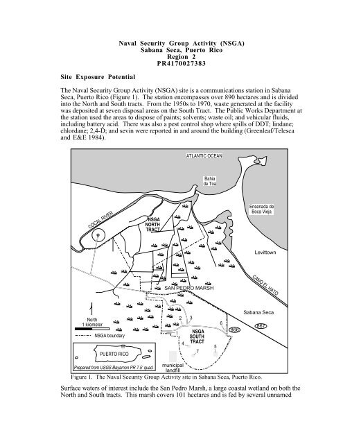
Site Exposure Potential<br />
Naval Security Group Activity (<strong>NSGA</strong>)<br />
Sabana Seca, Puerto Rico<br />
Region 2<br />
PR4170027383<br />
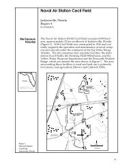
The Naval Security Group Activity (<strong>NSGA</strong>) site is a communications station in Sabana<br />
Seca, Puerto Rico (Figure 1). The station encompasses over 890 hectares <strong>and</strong> is divided<br />
into the North <strong>and</strong> South tracts. From the 1950s to 1970, waste generated at the facility<br />
was deposited at seven disposal areas on the South Tract. The Public Works Department at<br />
the station used the areas to dispose <strong>of</strong> paints; solvents; waste oil; <strong>and</strong> vehicular fluids,<br />
including battery acid. There was also a pest control shop where spills <strong>of</strong> DDT; lindane;<br />
chlordane; 2,4-D; <strong>and</strong> sevin were reported in <strong>and</strong> around the building (Greenleaf/Telesca<br />
<strong>and</strong> E&E 1984).<br />
ATLANTIC OCEAN<br />
Bahia<br />
de Toa<br />
COCAL RIVER<br />
<strong>NSGA</strong><br />
NORTH<br />
TRACT<br />
Ensenada de<br />
Boca Vieja<br />
Levittown<br />
SAN PEDRO MARSH<br />
CANO EL HATO<br />
North<br />
1 kilometer<br />
<strong>NSGA</strong> boundary<br />
❊<br />
PUERTO RICO<br />
1<br />
2 3<br />
4<br />
<strong>NSGA</strong><br />
SOUTH<br />
TRACT<br />
7<br />
5<br />
6<br />
866<br />
Sabana Seca<br />
867<br />
Prepared from USGS Bayamon PR 7.5' quad.<br />
municipal<br />
l<strong>and</strong>fill<br />
Figure 1. The Naval Security Group Activity site in Sabana Seca, Puerto Rico.<br />
Surface waters <strong>of</strong> interest include the San Pedro Marsh, a large coastal wetl<strong>and</strong> on both the<br />
North <strong>and</strong> South tracts. This marsh covers 101 hectares <strong>and</strong> is fed by several unnamed
streams that flow through the facility. There are numerous drainage ditches throughout the<br />
marsh. The wetl<strong>and</strong> flows into the Cocal River, which flows along the western border <strong>of</strong><br />
the facility <strong>and</strong> discharges into the Atlantic <strong>Ocean</strong> to the north. There is a mangrove area<br />
along the northeast part <strong>of</strong> the north tract <strong>and</strong> along the border <strong>of</strong> the Cocal River. A canal,<br />
Cano el Hato, is east <strong>of</strong> the site <strong>and</strong> flows into the Atlantic <strong>Ocean</strong>. The ground on the<br />
<strong>NSGA</strong> facility allows water to rapidly filtrate into the aquifer. Groundwater movement is<br />
considered rapid <strong>and</strong> flows north into the Cocal River <strong>and</strong> Atlantic <strong>Ocean</strong><br />
(Greenleaf/Telesca <strong>and</strong> E&E 1984).<br />
The pathways <strong>of</strong> concern to NOAA include groundwater flow <strong>and</strong> surface water run<strong>of</strong>f to<br />
the Cocal River, San Pedro Marsh, <strong>and</strong> the Atlantic <strong>Ocean</strong>.<br />
Site-Related Contamination<br />
No extensive on-site study has assessed contaminants at the <strong>NSGA</strong> site. Due to the wide<br />
variety <strong>of</strong> materials used <strong>and</strong> disposed <strong>of</strong> on the facility, it is not possible to determine<br />
which contaminants may pose a major threat to natural resources. Materials known to have<br />
been used on-site include pesticides, paint materials, arsenic, trace metals, <strong>and</strong> industrial<br />
<strong>and</strong> residential wastes (Greenleaf/Telesca <strong>and</strong> E&E 1984).<br />
NOAA Trust Habitats <strong>and</strong> Species in Site Vicinity<br />
The habitats <strong>of</strong> concern to NOAA include the Cocal River, San Pedro Marsh, <strong>and</strong> the<br />
Atlantic <strong>Ocean</strong> (Table 1). A forthcoming management study done by the U.S. Fish <strong>and</strong><br />
Wildlife <strong>Service</strong> for the Navy will add further resource information. The Cocal River <strong>and</strong><br />
San Pedro Marsh support a large population <strong>of</strong> l<strong>and</strong> crabs, which are important both<br />
recreationally <strong>and</strong> commercially. These l<strong>and</strong> crabs live along the banks <strong>of</strong> the Cocal River<br />
<strong>and</strong> in the marsh area. Catadromous freshwater shrimp migrate through the Cocal River to<br />
spawn in the Atlantic <strong>Ocean</strong>. These shrimp are collected both in the river <strong>and</strong> on the shores<br />
<strong>of</strong> the Atlantic <strong>Ocean</strong>. Shallow water coastal habitat that might be used as nursery is limited<br />
near the shoreline <strong>of</strong> the Atlantic due to a rapid increase in water depth. Two threatened<br />
species, the green sea turtle <strong>and</strong> the loggerhead sea turtle, are found along the coast<br />
(Lopez 1989).<br />
Table 1. Selected NOAA trust resource use <strong>of</strong> the Cocal River, San Pedro Marsh, <strong>and</strong><br />
the Atlantic <strong>Ocean</strong> near Sabana Seca, Puerto Rico (Lopez 1989).<br />
Species Cocal River San Pedro Marsh Atlantic <strong>Ocean</strong><br />
INVERTEBRATES<br />
blue crab X X X<br />
freshwater shrimp X X<br />
l<strong>and</strong> crab X X<br />
FISH<br />
grunt<br />
X<br />
snook X X<br />
tarpon X X<br />
MISCELLANEOUS<br />
green turtle<br />
loggerhead turtle<br />
X<br />
X
<strong>Response</strong> Category: Undetermined<br />
Current Stage <strong>of</strong> Site Action: RI/FS Workplan<br />
EPA Site Manager<br />
Juan Dazila 212-264-6669<br />
NOAA Coastal Resource Coordinator<br />
John Lindsay 404-347-5231<br />
References<br />
Greenleaf/Telesca & Ecology <strong>and</strong> Environment. 1984. Initial Assessment Study <strong>of</strong> Naval<br />
Security Group Activity, Sabana Seca <strong>and</strong> Naval Communications Station, Puerto Rico.<br />
Miami: Navy Assessment <strong>and</strong> Control <strong>of</strong> Installation Pollutants (NACIP) Department.<br />
Naval Energy <strong>and</strong> Environmental Support Activity (NAVENENSA).<br />
Lopez, F., fisheries biologist, U.S. Fish <strong>and</strong> Wildlife <strong>Service</strong>, Cabo Rojo, Puerto Rico,<br />
personal communication, January 16, 1989.