Detroit River - NOAA's Ocean Service Office of Response and ...
Detroit River - NOAA's Ocean Service Office of Response and ...
Detroit River - NOAA's Ocean Service Office of Response and ...

Create successful ePaper yourself
Turn your PDF publications into a flip-book with our unique Google optimized e-Paper software.
<strong>Detroit</strong> <strong>River</strong><br />
User’s Guide<br />
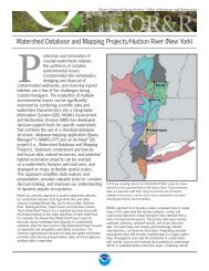
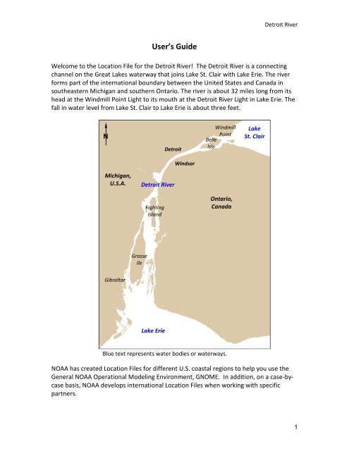
Welcome to the Location File for the <strong>Detroit</strong> <strong>River</strong>! The <strong>Detroit</strong> <strong>River</strong> is a connecting<br />
channel on the Great Lakes waterway that joins Lake St. Clair with Lake Erie. The river<br />
forms part <strong>of</strong> the international boundary between the United States <strong>and</strong> Canada in<br />
southeastern Michigan <strong>and</strong> southern Ontario. The river is about 32 miles long from its<br />
head at the Windmill Point Light to its mouth at the <strong>Detroit</strong> <strong>River</strong> Light in Lake Erie. The<br />
fall in water level from Lake St. Clair to Lake Erie is about three feet.<br />
N<br />
<strong>Detroit</strong><br />
Windmill<br />
Point<br />
Belle<br />
Isle<br />
Lake<br />
St. Clair<br />
Windsor<br />
Michigan,<br />
U.S.A.<br />
<strong>Detroit</strong> <strong>River</strong><br />
Fighting<br />
Isl<strong>and</strong><br />
Ontario,<br />
Canada<br />
Grosse<br />
Ile<br />
Gibraltar<br />
Lake Erie<br />
Blue text represents water bodies or waterways.<br />
NOAA has created Location Files for different U.S. coastal regions to help you use the<br />
General NOAA Operational Modeling Environment, GNOME. In addition, on a case-bycase<br />
basis, NOAA develops international Location Files when working with specific<br />
partners.<br />
1
<strong>Detroit</strong> <strong>River</strong><br />
Each Location File contains information about local oceanographic conditions that<br />
GNOME uses to model oil spills in the area covered by that Location File. Each Location<br />
File also contains references to help you learn more about the location you are<br />
simulating.<br />
As you work with the Location File for the <strong>Detroit</strong> <strong>River</strong>, GNOME will prompt you to:<br />
1. Choose the model settings (start date <strong>and</strong> time, <strong>and</strong> run duration).<br />
2. Set the <strong>Detroit</strong> <strong>River</strong> flow rate.<br />
3. Input the wind conditions.<br />
GNOME guides you through each <strong>of</strong> these choices. Each window has a button that<br />
leads you to helpful information <strong>and</strong> the general Help topic list. If you need help setting<br />
up the model, click the “Help” button. To learn more about setting the river flow rate,<br />
click the “Finding Flow Data” button. When you need to input the wind conditions in<br />
the “Choosing Wind Type” window, you can click the “Finding Wind Data” button to see<br />
a list <strong>of</strong> web sites that publish wind data for this region.<br />
More information about GNOME <strong>and</strong> Location Files is available at<br />
http://response.restoration.noaa.gov/gnome.<br />
Background<br />
Technical Documentation<br />
The <strong>Detroit</strong> <strong>River</strong> flows from Lake St. Clair on the north to Lake Erie on the south. The<br />
river is approximately 32 miles long <strong>and</strong> forms part <strong>of</strong> the international boundary<br />
between the United States <strong>and</strong> Canada. The upper third <strong>of</strong> the river is narrow channel<br />
whereas the lower two-thirds widens <strong>and</strong> has many isl<strong>and</strong>s.<br />
Current Patterns<br />
The <strong>Detroit</strong> <strong>River</strong> Location File contains one current pattern. The current pattern was<br />
created with the NOAA Current Analysis for Trajectory Simulation (CATS) hydrodynamic<br />
application. The tidal current pattern is calibrated using the NOAA Center for<br />
Operational <strong>Ocean</strong>ographic Products <strong>and</strong> <strong>Service</strong>s (CO-OPS) port stations in the <strong>Detroit</strong><br />
<strong>River</strong>. It should be noted that the model should not be used if the river is ice covered.<br />
References<br />
You can get more information about the <strong>Detroit</strong> <strong>River</strong> area from these publications <strong>and</strong><br />
web sites:<br />
2
<strong>Detroit</strong> <strong>River</strong><br />
General Information<br />
<strong>Detroit</strong>/Wayne County Port Authority<br />
http://www.portdetroit.com/statistics/index.htm#GREATLAKESWATERLEVELS<br />
Link to <strong>Detroit</strong>/Wayne County Port Authority <strong>and</strong> water levels in the Great Lakes.<br />
NOAA: Center for Operational <strong>Ocean</strong>ographic Products <strong>and</strong> <strong>Service</strong>s<br />
http://glakesonline.nos.noaa.gov/<br />
Provides immediate graphical <strong>and</strong> tabular water level <strong>and</strong> meteorological data from<br />
National <strong>Ocean</strong> <strong>Service</strong> (NOS) water level stations located along the projected path <strong>of</strong><br />
severe storms.<br />
U.S. Army Corps <strong>of</strong> Engineers: <strong>Detroit</strong> District<br />
http://www.lre.usace.army.mil/<br />
The Corps is an important partner in Congressionally-authorized water resource<br />
projects (related to navigation, flood control, beach erosion, <strong>and</strong> other activities)<br />
designed to help protect the economy <strong>and</strong> the environment <strong>of</strong> U.S. coastal areas<br />
U.S. Army Corps <strong>of</strong> Engineers: <strong>Detroit</strong> District Hydraulics <strong>and</strong> Hydrology<br />
http://www.lre.usace.army.mil/greatlakes/hh/<br />
Links to water levels, outflows, weather information, <strong>and</strong> flood monitoring.<br />
Great Lakes Observing System (GLOS)<br />
http://glos.us/<br />
Provides public access to critical, real-time <strong>and</strong> historical information about the Great<br />
Lakes, St. Lawrence <strong>River</strong>, <strong>and</strong> interconnecting waterways.<br />
GLOS: Huron-Erie Corridor Nowcast/Forecast<br />
http://glos.us/hecwfs/<br />
Online access to real-time forecasts <strong>of</strong> levels <strong>and</strong> flows throughout the Huron-Erie<br />
Corridor (HEC).<br />
U.S. Army Corps <strong>of</strong> Engineers: <strong>Detroit</strong> <strong>River</strong><br />
http://www.lre.usace.army.mil/greatlakes/hh/outflows/discharge_measurements/d<br />
etroit_river/<br />
Background on the <strong>Detroit</strong> <strong>River</strong>.<br />
<strong>Ocean</strong>ography<br />
Visualization <strong>of</strong> Drifting Buoy Deployments on Upper <strong>Detroit</strong> <strong>River</strong> within the Great<br />
Lakes Waterway from August 28-30, 2001<br />
http://mi.water.usgs.gov/pubs/OF/OF02-1/<br />
U.S. Geological Survey Open File Report 02-1. Lansing, Michigan, 2002.<br />
Drifting buoys containing global positioning system (GPS) receivers were deployed on<br />
3
<strong>Detroit</strong> <strong>River</strong><br />
the <strong>Detroit</strong> <strong>River</strong> to help investigate flow characteristics <strong>of</strong> four selected reaches as part<br />
<strong>of</strong> a source water assessment study <strong>of</strong> public water intakes.<br />
USGS: Flow Modeling Study <strong>of</strong> the St. Clair - <strong>Detroit</strong> <strong>River</strong> Waterway<br />
http://mi.water.usgs.gov/progproj/mi08900.html<br />
A study that identifies likely sources <strong>of</strong> water to public supply intakes <strong>and</strong> provides a<br />
basis for planning emergency responses to contaminant spills.<br />
Great Lakes Information Network (GLIN): Lake St. Clair<br />
http://www.great-lakes.net/lakes/stclair.html<br />
A partnership that provides an ecosystem-based approach to management <strong>of</strong> the<br />
natural, cultural, <strong>and</strong> economic resources <strong>of</strong> the Great Lakes.<br />
An Acoustic Doppler Current Pr<strong>of</strong>iler Survey <strong>of</strong> Flow Velocities in <strong>Detroit</strong> <strong>River</strong>, a<br />
Connecting Channel <strong>of</strong> the Great Lakes<br />
http://mi.water.usgs.gov/pubs/OF/OF03-219/index.php<br />
U.S. Geological Survey Open-File Report 03-219. Lansing, Michigan, 2003.<br />
Acoustic Doppler current pr<strong>of</strong>ilers (ADCP) were used to survey flow velocities in <strong>Detroit</strong><br />
<strong>River</strong> from July 8-19, 2002, as part <strong>of</strong> a study to assess the susceptibility <strong>of</strong> public water<br />
intakes to contaminants on the St. Clair-<strong>Detroit</strong> <strong>River</strong> Waterway.<br />
A Two-Dimensional Hydrodynamic Model <strong>of</strong> the St. Clair-<strong>Detroit</strong> <strong>River</strong> Waterway in the<br />
Great Lakes Basin<br />
http://mi.water.usgs.gov/pubs/WRIR/WRIR01-4236/index.php<br />
U.S. Geological Survey Water-Resources Investigation 01-4236. Lansing, Michigan, 2001.<br />
A two-dimensional hydrodynamic model was developed to compute flow velocities <strong>and</strong><br />
water levels as part <strong>of</strong> a source water assessment <strong>of</strong> public water intakes.<br />
Wind <strong>and</strong> Weather<br />
National Weather <strong>Service</strong>, <strong>Detroit</strong>/Pontiac, MI<br />
http://www.crh.noaa.gov/dtx/<br />
Current weather conditions <strong>and</strong> forecasts for locations throughout Michigan.<br />
National Weather <strong>Service</strong>, <strong>Detroit</strong>/Pontiac, MI, Marine Forecasts<br />
http://www.crh.noaa.gov/dtx/marine.php<br />
Graphical marine forecasts for Lake Huron <strong>and</strong> Lake St. Clair.<br />
Michigan State Information from Interactive Weather Information Network (IWIN)<br />
http://www.weather.gov/view/states.phpstate=Mi&map=on<br />
Current, site-specific weather observations for Michigan locations.<br />
4
<strong>Detroit</strong> <strong>River</strong><br />
Interactive Weather Information Network (IWIN), Forecasts from Michigan (text only<br />
version)<br />
http://www.weather.gov/view/states.phpstate=mi<br />
State <strong>and</strong> zone forecasts <strong>and</strong> weather data for Michigan.<br />
Oil Spill <strong>Response</strong><br />
NOAA Emergency <strong>Response</strong> Division (ERD)<br />
http://response.restoration.noaa.gov<br />
Tools <strong>and</strong> information for emergency responders <strong>and</strong> planners, <strong>and</strong> others concerned<br />
about the effects <strong>of</strong> oil <strong>and</strong> hazardous chemicals in our waters <strong>and</strong> along our coasts.<br />
5