Puget Sound Naval Shipyard - NOAA's Ocean Service Office of ...
Puget Sound Naval Shipyard - NOAA's Ocean Service Office of ...
Puget Sound Naval Shipyard - NOAA's Ocean Service Office of ...
- No tags were found...

Create successful ePaper yourself
Turn your PDF publications into a flip-book with our unique Google optimized e-Paper software.
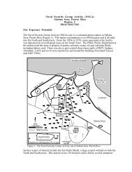
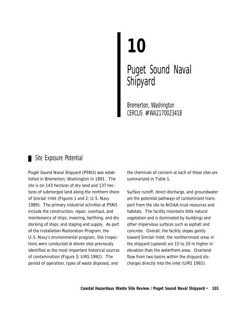
Region 10 • 10110<strong>Puget</strong> <strong>Sound</strong> <strong>Naval</strong><strong>Shipyard</strong>Bremerton, WashingtonCERCLIS #WA2170023418Site Exposure Potential<strong>Puget</strong> <strong>Sound</strong> <strong>Naval</strong> <strong>Shipyard</strong> (PSNS) was establishedin Bremerton, Washington in 1891. Thesite is on 143 hectares <strong>of</strong> dry land and 137 hectares<strong>of</strong> submerged land along the northern shore<strong>of</strong> Sinclair Inlet (Figures 1 and 2; U.S. Navy1989). The primary industrial activities at PSNSinclude the construction, repair, overhaul, andmaintenance <strong>of</strong> ships; mooring, berthing, and drydocking <strong>of</strong> ships; and staging and supply. As part<strong>of</strong> the Installation Restoration Program, theU.S. Navy’s environmental program, Site Inspectionswere conducted at eleven sites previouslyidentified as the most important historical sources<strong>of</strong> contamination (Figure 3; URS 1992). Theperiod <strong>of</strong> operation, types <strong>of</strong> waste disposed, andthe chemicals <strong>of</strong> concern at each <strong>of</strong> these sites aresummarized in Table 1.Surface run<strong>of</strong>f, direct discharge, and groundwaterare the potential pathways <strong>of</strong> contaminant transportfrom the site to NOAA trust resources andhabitats. The facility maintains little naturalvegetation and is dominated by buildings andother impervious surfaces such as asphalt andconcrete. Overall, the facility slopes gentlytoward Sinclair Inlet; the northernmost areas inthe shipyard (upland) are 15 to 20 m higher inelevation than the waterfront areas. Overlandflow from two basins within the shipyard dischargesdirectly into the inlet (URS 1992).Coastal Hazardous Waste Site Review / <strong>Puget</strong> <strong>Sound</strong> <strong>Naval</strong> <strong>Shipyard</strong> • 101
102 • Region 10VancouverIslandCANADAUNITED STATESStrait <strong>of</strong> Juan de FucaEverettSeattle<strong>Puget</strong> <strong>Sound</strong><strong>Naval</strong> <strong>Shipyard</strong>■N0 5 10 15 20kilometersWashingtonTacoma<strong>Puget</strong> <strong>Sound</strong>Prepared from AAA Oregon, Washington map, 1993 edition.Figure 1. Location <strong>of</strong> the <strong>Puget</strong> <strong>Sound</strong> <strong>Naval</strong> <strong>Shipyard</strong>, Bremerton, Washington.102 • Coastal Hazardous Waste Site Review / <strong>Puget</strong> <strong>Sound</strong> <strong>Naval</strong> <strong>Shipyard</strong>
Region 10 • 103PortD y e sIllaheeOI nl e trc h a r dS oundP o r t W as hPassa geRic hi ng t o nNarrow sBremertont<strong>Puget</strong> <strong>Sound</strong><strong>Naval</strong> <strong>Shipyard</strong>I n l eRossPointS i ni rc l aGorstCreekCreekAndersonCreekRossBlackja ckCreekN0 1 2 3kilometersNOAA, September 1993. Prepared from USGS Seattle, WA, 1:100,000 scale topographic map.Figure 2. Location <strong>of</strong> the <strong>Puget</strong> <strong>Sound</strong> <strong>Naval</strong> <strong>Shipyard</strong> on Sinclair Inlet, Bremerton, Washington.Surface run<strong>of</strong>f from these small basins consistsprimarily <strong>of</strong> stormwater discharged via stormdrain outfalls and natural drainage channels.There is at least one combined sewage overflow(CSO) at PSNS, between Piers 6 and 7. TheCSO discharges a mixture <strong>of</strong> stormwater run<strong>of</strong>fand raw sewage when the combined sanitary andstorm sewer system’s hydraulic capacity is exceededduring a heavy rain storm.Coastal Hazardous Waste Site Review / <strong>Puget</strong> <strong>Sound</strong> <strong>Naval</strong> <strong>Shipyard</strong> • 103
104 • Region 10Note: Shading <strong>of</strong> individual site areasis used for distinguishing boundaries.<strong>Puget</strong> <strong>Sound</strong> <strong>Naval</strong> <strong>Shipyard</strong> boundarySite 7Site 8Site 11Site 10EastSite 6Site 10CentralSite 12 3Site 9PIER 8Site 10WestSite 1PIER 7PIER 6Site 6PIER 5PIER 4Site 6PIER 3Site 3Site 6MOORING GMOORING FMOORING EPIER DSUPPLYPIERPIER BDRYDOCK 6MOORING ASinclair InletN0 100 200 300 400metersAdapted from U.S. Navy, 1989Figure 3. Locations <strong>of</strong> eleven sites where site inspections were performed at <strong>Puget</strong> <strong>Sound</strong> <strong>Naval</strong> <strong>Shipyard</strong>.104 • Coastal Hazardous Waste Site Review / <strong>Puget</strong> <strong>Sound</strong> <strong>Naval</strong> <strong>Shipyard</strong>
Region 10 • 105Two different sand and gravel aquifers have beendescribed near PSNS (URS 1992). The upperaquifer overlies a silt and clay aquitard throughoutthe area. The base <strong>of</strong> the aquifer ranges fromnear sea level to 90 m above sea level. Thesaturated thickness <strong>of</strong> the upper aquifer rangesfrom 6 m to more than 60 m. The lower aquiferoccurs at elevations ranging from slightly abovemean sea level to approximately 90 m belowmean sea level, and ranges in thickness from a fewmeters to 90 m. Despite the predominance <strong>of</strong>impervious surfaces, contaminants may haveentered the groundwater via leaking undergroundstorage tanks and cracked floors.Previous investigations at the site indicate that thethree fill areas that constitute Site 10 (Figure 3;Table 1) are hydraulically connected to SinclairInlet, and that groundwater in both aquifersmoves toward Sinclair Inlet (URS 1992). Contaminantsfrom the majority <strong>of</strong> the sites listed inTable 1 may have entered the groundwater andcould subsequently be transported to SinclairInlet.NOAA Trust Habitats and SpeciesHabitats <strong>of</strong> concern to NOAA are surface waterand associated bottom substrates <strong>of</strong> Sinclair Inlet.Compared with other regions <strong>of</strong> <strong>Puget</strong> <strong>Sound</strong>,Sinclair Inlet is relatively shallow, an average <strong>of</strong>13 to 22 m deep (U.S. Department <strong>of</strong> Commerce1979). Substrates are predominantly mud, withareas <strong>of</strong> sand deposits along the southern shore <strong>of</strong>Sinclair Inlet (WDNR 1977). Currents nearPSNS are weak and variable (average currentspeed is 0.08 knots; Tetra Tech 1988); tidalamplitude averages 2.5 m. Surface waters are cool(6.6 to 16.6°C), saline (24 to 31 ppt), and welloxygenated(average 7.9 mg/l; WDNR 1977).Shallow nearshore depths and tidal wetlandscombined with deeper, cooler troughs in thecenter <strong>of</strong> the inlet provide a diverse habitat.A variety <strong>of</strong> anadromous, estuarine, and invertebrateNOAA trust resources use Sinclair Inlet(Table 2: U.S. Fish and Wildlife <strong>Service</strong> 1981;Freymond personal communication 1991; Fyfepersonal communication 1991; WDF 1992;Zichke personal communication 1992). SinclairInlet and its drainages support various salmonids,including wild stocks <strong>of</strong> early and late chumsalmon, sea-run cutthroat trout, and steelheadtrout (Brooks personal communication 1992).Chum salmon is the most abundant and widelydistributed species, followed by coho salmon.Chinook salmon are also present, but not as wildfall stocks. Chinook populations are limited byavailable upstream spawning habitat. Mostupland drainages associated with Sinclair Inletprovide important salmon spawning habitats,especially the Gorst Creek (at the head <strong>of</strong> theinlet) and Blackjack Creek watersheds (Figure 2).The Anderson and Ross creek systems mayoccasionally support salmonids as well. Cutthroattrout are suspected to use all salmon habitat,while steelhead are less widely distributed(Freymond personal communication 1991).Several streams are stocked regularly by either theCoastal Hazardous Waste Site Review / <strong>Puget</strong> <strong>Sound</strong> <strong>Naval</strong> <strong>Shipyard</strong> • 105
106 • Region 10Table 1. Sites, waste types, and chemicals <strong>of</strong> concern for eleven sites evaluated at <strong>Puget</strong> <strong>Sound</strong> <strong>Naval</strong><strong>Shipyard</strong> as part <strong>of</strong> Site Inspection (URS 1992).SitePeriod <strong>of</strong>OperationWaste TypeSize <strong>of</strong>Area/EstimatedQuantityChemicals <strong>of</strong> Concern1 Fill Area, MooringA to Dry Dock 51960 - 1974 Construction debris,rubble, spentabrasive grit1-ha/54,000m 3 <strong>of</strong> fillTrace elements, acids, PCBs3 Helicopter PadArea1963 - 1972 Plating wastes,unopened paintcans, oils, metalparts and shavings114,000 liters Trace elements, acids,organic solvents, oil-basedformulations, epoxies,organotin compounds6 Drain Outfalls Sanitary-until1957;Storm - untilpresentStorm and sanitarysewer dischargeUnknownPCBs, organic compounds,trace elements7 Building 99, OldPlating ShopUnknownChemical leakagethrough crackedfloorUnknownAcids, bases, sodiumcyanide, calcium sulfate,trace elements8 Building 106, OldPower PlantUnknownOil from leakingundergroundstorage tanksUnknownPCBs9 CraneMaintenanceAreaPresentDebris from cranemaintenance andpaintingUnknownTrace elements10 Landfill Areas,WaterfrontAreas a Unknown Fill (oily sludge,automobile scrap,construction andshipyard debris,spent abrasive grit)UnknownPCBs, trace elements,organic and organotincompounds11 Oil Tank 316AreaUntil 1988Fuel from leakingtanks, possiblycontaminated soilsfor fill materialsUnknownPetroleum hydrocarbons,trace elements, volatileorganic and organotincompounds12 Acid Drain SlabAreaUnknown Unknown Unknown Trace elements, cyanide,PCBsa: The Waterfront Area Landfills are divided into three separate locations: Site 10 East, Site 10 Central, andSite 10 West.state or combined tribal/volunteer programs toenhance runs (Brooks personal communication1992).Several estuarine fish species use Sinclair Inlet forspawning, nursery, and adult forage habitat (U.S.Fish and Wildlife <strong>Service</strong> 1981). According to106 • Coastal Hazardous Waste Site Review / <strong>Puget</strong> <strong>Sound</strong> <strong>Naval</strong> <strong>Shipyard</strong>
Region 10 • 107Table 2. NOAA trust fish and invertebrate resources that use Sinclair Inlet near Bremerton, Washington.Common NameSpecies Habitat FisheriesSpawning Nursery Adult Comm. Recr.Scientific NameGround Ground Forage Fishery FisheryANADROMOUS FISHCutthroat trout Oncorhynchus clarki ♦ ♦ ♦ ♦Steelhead trout Oncorhynchus mykiss ♦ ♦ ♦ ♦Chum salmon Oncorhynchus keta ♦ ♦ ♦ ♦ ♦Coho salmon Oncorhynchus kisutch ♦ ♦ ♦ ♦ ♦Chinook salmon Oncorhynchus tshawytscha ♦ ♦ ♦ ♦ ♦MARINE FISHSablefish Anoplopoma fimbria ♦Arrow goby Clevelandia ios ♦ ♦ ♦♦ ♦Pacific herring Clupea harengus pallasi ♦ ♦ ♦ ♦ ♦Shiner perch Cymatogaster aggregata ♦ ♦ ♦ ♦Striped sea perch Embiotoca lateralis ♦ ♦ ♦ ♦Buffalo sculpin Enophrys bison ♦ ♦Pacific cod Gadus macrocephalus ♦3-spine stickleback Gasterosteus aculeatus ♦ ♦ ♦♦ ♦Silver smelt Hypomesus pretiosus ♦ ♦ ♦ ♦ ♦Rock sole Lepidopsetta bilineata ♦ ♦ ♦ ♦Pacific staghorn sculpin Leptocottus armatus ♦ ♦Pacific hake Merluccius productus ♦ ♦ ♦Dover sole Microstomus pacificus ♦ ♦ ♦ ♦Ling cod Ophidon elongatus ♦ ♦ ♦English sole Parophyrs vetulus ♦ ♦ ♦ ♦Starry flounder Platichthys stellatus ♦ ♦ ♦ ♦C-O sole Pleuronichthys coenosus ♦ ♦ ♦ ♦Sand sole Psettichthys melanostictus ♦ ♦CabezonScorpaenichthys♦ ♦♦ ♦marmoratusRockfish Sebastes spp. ♦ ♦ ♦Pile perch Rhacochilus vacca ♦ ♦ ♦ ♦INVERTEBRATE SPECIESDungeness crab Cancer magister ♦ ♦Red rock crab Cancer productus ♦ ♦Horse clam Clinocardium nuttali ♦ ♦ ♦Pacific oyster Crassostrea gigas ♦ ♦ ♦Kumamoto oyster Crassostrea gigas♦ ♦ ♦kumamotoPacific coast squid Loligo opalescens ♦Sea cucumber Parastichopus californicus ♦ ♦ ♦Littleneck clam Protothaca staminea ♦ ♦ ♦Kelp crab <strong>Puget</strong>tia gracilis ♦ ♦ ♦Butter clam Saxidomus giganteus ♦ ♦ ♦Manila clam Venerupis japonica ♦ ♦ ♦Coastal Hazardous Waste Site Review / <strong>Puget</strong> <strong>Sound</strong> <strong>Naval</strong> <strong>Shipyard</strong> • 107
108 • Region 10the Washington State Department <strong>of</strong> Fisheries,surf smelt spawn in the intertidal zone <strong>of</strong> thesouthern section <strong>of</strong> Sinclair Inlet and use bothSinclair Inlet and nearby Dyes Inlet as nurseryhabitat (Zichke personal communication 1991).Herring may spawn near PSNS. Numerousspecies <strong>of</strong> demersal fish, including Pacific hake,Dover sole, ling cod, and starry flounder, plusvarious species <strong>of</strong> perch, rockfish, and sculpin useSinclair Inlet for seasonal nursery and adult foragehabitat. These species may also congregate nearthe piers and pilings <strong>of</strong> PSNS.Broad intertidal flats and bars provide excellentspawning and nursery substrate for molluscs.Littleneck, Manila, butter, and horse clams areabundant over most intertidal areas, particularlynear Gorst Creek. Sea cucumbers are also abundantin Sinclair Inlet (Fyfe personal communication1991). Oyster and adult crab populationsare small. Dungeness crab, rock crab, and kelpcrab tend to congregate near Rich Passage (Figure2). Squid may drift seasonally into SinclairInlet and spawn (Zichke personal communication1991).Fish and shellfish fisheries in Sinclair Inlet arelimited. Commercially harvested salmon make upthe majority <strong>of</strong> landings from Sinclair Inlet.Substantial Suquamish Tribe effort is directedtowards salmonid runs in the vicinity <strong>of</strong> SinclairInlet. Most fishing occurs in Port Orchard<strong>Sound</strong> above Illahee or in Sinclair Inlet (Figure2). Three principal salmon fisheries occur annuallyon stocks <strong>of</strong> Sinclair Inlet origin: an August-September fall chinook tribal gillnet fishery, whichtargets returning enhanced chinook from theGorst Creek rearing facility; the fall treaty andnon-treaty harvest <strong>of</strong> chum salmon; and the falltreaty and non-treaty harvest <strong>of</strong> coho salmon(Zichke personal communication 1992). Smallcatches <strong>of</strong> smelt and perch also occur.Recreational fishing effort in Sinclair Inlet isreported to be light, although catch data were notavailable. Summer steelhead and cutthroat troutfishing occurs in most streams which discharge tothe inlet (Freymond personal communication1991). In areas <strong>of</strong>f the Bremerton shoreline andin Port Washington Narrows (Figure 2), there isusually moderate sport fishing for salmon fromSeptember to late November. The water aroundRoss Point (Figure 2) supports a recreational surfsmelt fishery (Brooks personal communication1992; WDF 1992). The sandy southern shore <strong>of</strong>Sinclair Inlet supports a regular demersal sportfishery targeting Pacific cod, starry flounder, andseveral species <strong>of</strong> sole (WDNR 1977). There isinfrequent sport crabbing for Dungeness crab<strong>of</strong>fshore in Port Orchard <strong>Sound</strong> (Zichke personalcommunication 1992).The commercial harvest <strong>of</strong> bivalves from SinclairInlet has never been certified and is now prohibitedby the Washington State Department <strong>of</strong>Health because <strong>of</strong> high fecal coliform counts(Melvin personal communication 1991; Noshopersonal communication 1991). Although thisprohibition does not <strong>of</strong>ficially extend to all recreationalharvests, the Bremerton-Kitsap County108 • Coastal Hazardous Waste Site Review / <strong>Puget</strong> <strong>Sound</strong> <strong>Naval</strong> <strong>Shipyard</strong>
Region 10 • 109Health Department has recommended againstharvesting bottom-dwelling organisms, includingfish, from Sinclair Inlet (Jones personal communication1993).Site-Related ContaminationDuring site investigations 283 soil samples, 239groundwater samples, 42 surface water samples,and 61 sediment samples were collected (URS1992). Samples were analyzed for some or all <strong>of</strong>the following target analytes: VOCs, SVOCs,pesticides/PCBs, trace elements, cyanide, andTPH. Phenols (GeoEngineers 1986; U.S. EPA1986a) and tributyl tin (Grovhoug et al. 1987)were measured in some studies. Detection limitswere not available.Trace elements and PAHs are the primary contaminants<strong>of</strong> concern to NOAA. Other contaminants<strong>of</strong> concern include PCBs and other organiccompounds such as phthalate esters and chlorinatedbenzenes. These contaminants werelimited in distribution and were not found atconcentrations exceeding screening guidelines inall sampled media. The maximum concentrations<strong>of</strong> contaminants detected in media collected fromthe eleven waste sites at PSNS are presented inTable 3.Ten trace elements were detected at elevatedconcentrations in soil, sediment, and groundwater(Table 3). Concentrations <strong>of</strong> all trace elementsmeasured in soil, except silver, exceededaverage values for U.S. soil (Lindsay 1979).Similar substances were detected in groundwaterat concentrations exceeding their respectivemarine chronic AWQC by factors greater thanten. All ten trace elements were detected insediments collected from Sites 3 and 6 at concentrationsexceeding their ERL screening guidelines(Long and MacDonald 1992). Arsenic, copper,lead, mercury, nickel, and zinc were detected insediment samples from these same areas atconcentrations exceeding their respective ERMscreening guidelines (Long and MacDonald1992).Toxicity tests were performed at the Pier DDredging Project to determine whether thedredged sediment was suitable for open-waterdisposal in <strong>Puget</strong> <strong>Sound</strong> (U.S. Navy 1992). Theresults indicated that sediments were toxic to theamphipod Rhepoxynius abronius. The arealextent <strong>of</strong> the toxic sediments has not beendetermined. Comparison <strong>of</strong> the concentrations<strong>of</strong> zinc in the sediments with toxicity test dataobtained from the scientific literature suggeststhat most <strong>of</strong> the sediment within the boundaries<strong>of</strong> PSNS is potentially toxic to sensitive marineorganisms.In addition, benthic infaunal analyses wereperformed with the site investigations at 12locations within PSNS boundaries and tworeference locations in Sinclair Inlet (URS 1992).Sediment samples were collected synoptically forchemistry analyses. Two <strong>of</strong> the on-site stationsand one <strong>of</strong> the reference stations could not belegitimately used in the analyses due to distinctlyCoastal Hazardous Waste Site Review / <strong>Puget</strong> <strong>Sound</strong> <strong>Naval</strong> <strong>Shipyard</strong> • 109
110 • Region 10Table 3. Maximum concentrations <strong>of</strong> contaminants <strong>of</strong> concern at waste sites located at PSNS(GeoEngineers 1986; U.S. EPA 1986a; URS 1992; and U.S. Navy 1992).ContaminantsGroundwaterWater (µg/l) Soils (mg/kg) Sediment (mg/kg)SurfaceAverageWater AWQC a Soils US Soils b Sediment ERL c ERM dInorganic SubstancesAntimony ND NR 500** 853 1 13.8 2 25Arsenic 1,860 NR 36 1,160 5 111 8.2 70Cadmium 174 NR 9.3 84.3 0.06 6.5 1.2 9.6Chromium 2,140 NR 50 735 100 102 80 370Copper 23,400 NR 2.9 10,400 30 1,709 34 270Lead 18,200 NR 8.5 11,100 10 603 47 220Mercury 203 NR 0.025 145 0.03 5.2 0.15 0.71Nickel 3,210 NR 8.3 1,030 40 56.0 21 52Silver ND NR 0.92** ND 0.05 2.9 1.0 3.7Zinc 23,900 NR 8 6 23,600 50 1,950 150 410Organic CompoundsPAHsAcenaphthene ND NR 710* 8 NA ND 0.160 0.5Fluorene ND NR NA 63 NA 230 0.019 0.54Phenanthrene ND NR 4.6** 170 NA 2,400 0.24 1.5Anthracene ND NR NA 3.9 NA 510 0.085 1.1Fluoranthene ND NR 16* 68 NA 2,800 0.600 5.1Pyrene ND NR NA 60 NA 3,100 0.66 2.6Benzo(a)anthracene ND NR NA 20 NA 1,600 0.26 1.6Chrysene ND NR NA 16 NA 1,700 0.38 2.8Benz<strong>of</strong>luoranthenes ND NR NA 22 NA 2,700 NA NABenzo(a)pyrene ND NR NA 14 NA ND 0.43 1.6Indeno(1,2,3-c,d)pyrene ND NR NA 36 NA 600 NA NABenzo(g,h,i)perylene ND NR NA 6.2 NA 700 NA NANaphthalene ND NR NA 260 NA ND 0.16 2.12-Methylnaphthalene ND NR NA 74 NA ND 0.07 0.67Dibenz(a,h)anthracene ND NR NA 1.3 NA 96 0.063 0.26a: Ambient water quality criteria for the protection <strong>of</strong> aquatic organisms. Marine chronic criteria arepresented (EPA 1986b) because waste sites are located near marine environments.b: Lindsay (1979).c: Effects Range-Low (Long and MacDonald 1992).d: Effects Range-Median (Long and MacDonald 1992).NA: Screening guidelines not available.ND: Not detected; detection limit not reported.NR: Not reported.+: Hardness-dependent criteria; 100 mg/l CaCO3 assumed.* Insufficient Data to Develop Criteria. Value Presented is the LOEL. - Lowest Observed Effect Level** Proposed Criteriondifferent characteristics in grain size and totalorganic carbon. Pollution-tolerant taxa represented56 to 82 percent <strong>of</strong> the taxa at ten <strong>of</strong> thetwelve PSNS stations as compared to only28 percent from the reference station. Althoughthe source <strong>of</strong> the impairment has not yet beendetermined, the results suggest that benthiccommunities near PSNS appear stressed on the110 • Coastal Hazardous Waste Site Review / <strong>Puget</strong> <strong>Sound</strong> <strong>Naval</strong> <strong>Shipyard</strong>
Region 10 • 111basis <strong>of</strong> richness, Shannon-Weaver DiversityIndex, Swartz’s Dominance Index, abundancebiomasscomparisons, and relative abundance <strong>of</strong>pollution-sensitive and pollution-tolerant taxa.Fyfe, D., Shellfish Biologist, Northwest IndianFisheries Council, Suquamish Tribe, Suquamish,Washington, personal communication, June 3,1991.SummaryA diverse group <strong>of</strong> anadromous, estuarine, andmarine NOAA trust species use Sinclair Inlet foradult forage, spawning, and nursery habitat.Salmon are fished both commercially and byIndian tribes; there are also several sport fisheriesin the Inlet. <strong>Puget</strong> <strong>Sound</strong> <strong>Naval</strong> <strong>Shipyard</strong> hasoperated on the north shore <strong>of</strong> Sinclair Inlet since1891, resulting in trace element and PAH contaminationin soils, groundwater, and sediments.These contaminants are extremely persistent inaquatic systems and may threaten sensitive lifestages <strong>of</strong> NOAA trust species and their habitat.ReferencesGeoEngineers. 1986. Supplemental report,geotechnical studies, dredging project, <strong>Puget</strong><strong>Sound</strong> <strong>Naval</strong> <strong>Shipyard</strong>, Bremerton, Washington.Tacoma: Sitts & Hill, Inc. 5 pp. + figures andattachments.Grovhoug, J.G., R.L. Fransham, and P.F.Seligman. 1987. Butyl tin compound concentrationsin selected U.S. harbor systems, a baselineassessment. Final Report. NOSC TechnicalReport 1155. San Diego: <strong>Naval</strong> <strong>Ocean</strong> SystemsCenter. 201 pp. + appendices.Jones, D., Environmental Health Specialist,Kitsap County Department <strong>of</strong> Health, Department<strong>of</strong> Environmental Health, Bremerton,Washington, personal communication, January19, 1993.Lindsay, W.L. 1979. Chemical Equilibria inSoils. New York: John Wiley & Sons. 449 pp.Brooks, R., Environmental Biologist, SuquamishTribe, Suquamish, Washington, personal communication,December 4, 1992.Freymond, W., Region 6 Fisheries ResourceManager, Division <strong>of</strong> Fisheries Management,Washington Department <strong>of</strong> Wildlife, Aberdeen,Washington, personal communication, June 4,1991.Long, E.R. and D.D. MacDonald. 1992. NationalStatus and Trends Program approach. In:Sediment Classification Methods Compendium.EPA 823-R-92-006. Washington, D.C.: <strong>Office</strong><strong>of</strong> Water, U.S. Environmental Protection Agency.Coastal Hazardous Waste Site Review / <strong>Puget</strong> <strong>Sound</strong> <strong>Naval</strong> <strong>Shipyard</strong> • 111
112 • Region 10Melvin, D., Water Quality Specialist, WashingtonState Department <strong>of</strong> Health, Shellfish Program,Olympia, Washington, personal communication,June 3, 1991.Nosho, T., Aquaculture Specialist, University <strong>of</strong>Washington Sea Grant, Seattle, Washington,personal communication, June 3, 1991.Tetra Tech. 1988. Sinclair and Dyes inlet actionProgram: initial data summaries and problemidentification. Seattle: U.S. EnvironmentalProtection Agency, <strong>Office</strong> <strong>of</strong> <strong>Puget</strong> <strong>Sound</strong>. 193pp. + appendices.U.S. Environmental Protection Agency. 1986b.Quality criteria for water. EPA 440/5-86-001.Washington, D.C.: U.S. Environmental ProtectionAgency, <strong>Office</strong> <strong>of</strong> Water Regulation andStandards, Criteria and Standards Division.U.S. Fish and Wildlife <strong>Service</strong>. 1981. Pacificcoast ecological inventory. Seattle, Washington.47122-A1-E1-250. Washington, D.C.: U.S.Department <strong>of</strong> the Interior. 1:250,000 scale map.U.S. Navy. 1989. Master Plan, Bremerton<strong>Naval</strong> Complex. San Bruno, California: WesternDivision, <strong>Naval</strong> Facilities Engineering Command.URS. 1992. Site Inspection Study, <strong>Puget</strong> <strong>Sound</strong><strong>Naval</strong> <strong>Shipyard</strong>, Bremerton, Washington.Silverdale, Washington: Engineering Field ActivityNorthwest, <strong>Naval</strong> Facilities EngineeringCommand.U.S. Department <strong>of</strong> Commerce. 1979. Nauticalchart 18445: <strong>Puget</strong> <strong>Sound</strong>, Possession <strong>Sound</strong> toOlympia including Hood Canal. Edition 15.Seattle: National <strong>Ocean</strong>ic and AtmosphericAdministration, National <strong>Ocean</strong> Survey.U.S. Environmental Protection Agency. 1986a.Reconnaissance survey <strong>of</strong> eight bays in <strong>Puget</strong><strong>Sound</strong>. Final Report. EPA 910/9-87-161.Seattle: U.S. Environmental Protection Agency,Region 10. 231 pp. + appendices.U.S. Navy. 1992. Unpublished data from thememorandum “Decision on the suitability <strong>of</strong>dredged material tested under PSDDA evaluationprocedures for the U.S. Navy Bremerton Pier-Ddredging project (OYB-2-012791) for disposal atthe Elliott Bay open-water disposal site.” Obtainedfrom R. Brooks, Suquamish Tribe,Suquamish, Washington.WDF. 1992. 1991 Catch Data for Area 10E,26C, 42K. Computer print-out. Request number994. Olympia: Washington Department <strong>of</strong>Fisheries.WDNR. 1977. Washington Marine Atlas.Division <strong>of</strong> Marine Land Management. Volume2. South Inland Waters. Olympia: WashingtonDepartment <strong>of</strong> Natural Resources.Zichke, J., Fisheries Harvest Manager,Suquamish Tribe, Suquamish, Washington,personal communications June 3, 1991; October30, 1992.112 • Coastal Hazardous Waste Site Review / <strong>Puget</strong> <strong>Sound</strong> <strong>Naval</strong> <strong>Shipyard</strong>