guide to outdoor activities 2009-2010 - South of France Tourism
guide to outdoor activities 2009-2010 - South of France Tourism
guide to outdoor activities 2009-2010 - South of France Tourism

You also want an ePaper? Increase the reach of your titles
YUMPU automatically turns print PDFs into web optimized ePapers that Google loves.
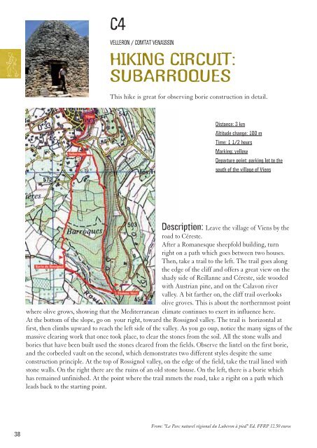
C4<br />
VELLERON / COMTAT VENAISSIN<br />
HIKING CIRCUIT:<br />
SUBARROQUES<br />
This hike is great for observing borie construction in detail.<br />
Distance: 3 km<br />
Altitude change: 100 m<br />
Time: 1 1/2 hours<br />
Marking: yellow<br />
Departure point: parking lot <strong>to</strong> the<br />
south <strong>of</strong> the village <strong>of</strong> Viens<br />
Description: Leave the village <strong>of</strong> Viens by the<br />
road <strong>to</strong> Céreste.<br />
After a Romanesque sheepfold building, turn<br />
right on a path which goes between two houses.<br />
Then, take a trail <strong>to</strong> the left. The trail goes along<br />
the edge <strong>of</strong> the cliff and <strong>of</strong>fers a great view on the<br />
shady side <strong>of</strong> Reillanne and Céreste, side wooded<br />
with Austrian pine, and on the Calavon river<br />
valley. A bit farther on, the cliff trail overlooks<br />
olive groves. This is about the northernmost point<br />
where olive grows, showing that the Mediterranean climate continues <strong>to</strong> exert its influence here.<br />
At the bot<strong>to</strong>m <strong>of</strong> the slope, go on your right, <strong>to</strong>ward the Rossignol valley. The trail is horizontal at<br />
first, then climbs upward <strong>to</strong> reach the left side <strong>of</strong> the valley. As you go oup, notice the many signs <strong>of</strong> the<br />
massive clearing work that once <strong>to</strong>ok place, <strong>to</strong> clear the s<strong>to</strong>nes from the soil. All the s<strong>to</strong>ne walls and<br />
bories that have been built used the s<strong>to</strong>nes cleared from the fields. Observe the lintel on the first borie,<br />
and the corbeeled vault on the second, which demonstrates two different styles despite the same<br />
construction principle. At the <strong>to</strong>p <strong>of</strong> Rossignol valley, on the edge <strong>of</strong> the field, take the trail lined with<br />
s<strong>to</strong>ne walls. On the right there are the ruins <strong>of</strong> an old s<strong>to</strong>ne house. On the left, there is a borie which<br />
has remained unfinished. At the point where the trail mmets the road, take a rigiht on a path which<br />
leads back <strong>to</strong> the starting point.<br />
38<br />
From: "Le Parc naturel régional du Luberon à pied" Ed. FFRP 12.50 euros